Bridge Statistics for Baileyville, Pennsylvania (PA)
Condition, Traffic, Stress, Structural Evaluation, Project Costs
- National Bridge Inventory (NBI) Statistics
- 10Number of bridges
- 36ft / 11.0mTotal length
- $5,782,000Total costs
- 8,434Total average daily traffic
- 458Total average daily truck traffic
- 9,169Total future (year 2032) average daily traffic
- National Bridge Inventory (NBI) Registered Bridges for Baileyville
- No street view available for this location
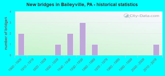
- New bridges - historical statistics
- 21900-1909
- 11930-1939
- 21940-1949
- 31950-1959
- 11960-1969
- 12010-2019
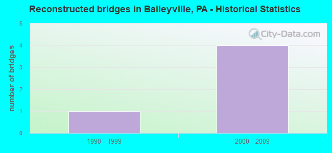
- Reconstructed bridges - Historical Statistics
- 11990-1999
- 42000-2009
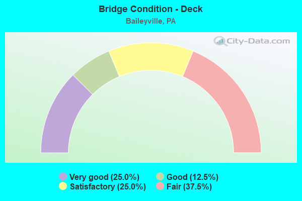
- Bridge Condition - Deck
- 25.0%Very good
- 12.5%Good
- 25.0%Satisfactory
- 37.5%Fair
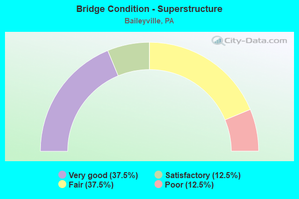
- Bridge Condition - Superstructure
- 37.5%Very good
- 12.5%Satisfactory
- 37.5%Fair
- 12.5%Poor
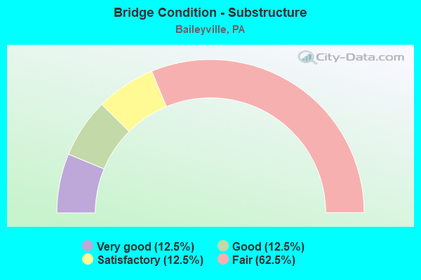
- Bridge Condition - Substructure
- 12.5%Very good
- 12.5%Good
- 12.5%Satisfactory
- 62.5%Fair
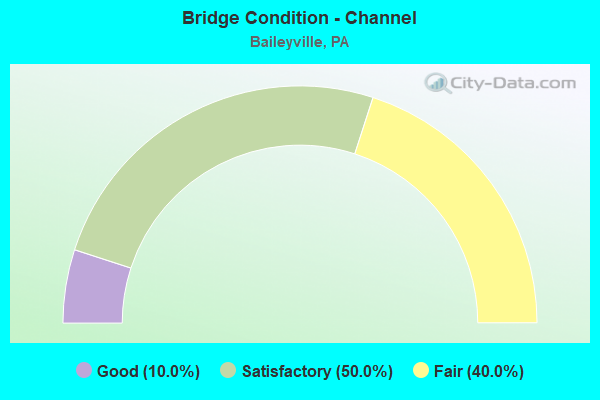
- Bridge Condition - Channel
- 10.0%Good
- 50.0%Satisfactory
- 40.0%Fair
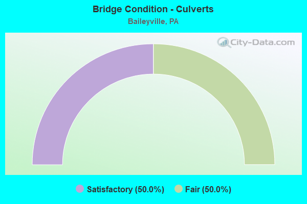
- Bridge Condition - Culverts
- 50.0%Satisfactory
- 50.0%Fair
Find on map >> Show street view
Structure Number: 9234, Location: BAILEYVILLE (Lat: 40.704356, Lng: -77.981161), Route carried "on" structure: State highway 45, Year Built: 1952, Year Reconstructed: 2009, Status: Open, Structure Length: 0.70m (2.30ft), Average Daily Traffic: 1,792 (year 2021), Truck Traffic: 8%, Average Future Daily Traffic: 2,011 (year 2041), Design Load: HS 20, Features Intersected: SPRUCE CREEK
Minimum Vertical Clearance: 30+ m (98+ ft), Kilometerpoint: 0.512, Lanes on structure: 2, Base Highway Network: Yes, Owner: State Highway Agency, Approaching Roadway Width: 8.2m (26.9ft), Skew: 3 degrees, Material/Design: Prestressed concrete, Design/Construction: Box Beam or Girders - Single/Spread, Number Of Spans In Main Unit: 1, Length of Maximum Span: 7.0m (23.0ft), Curb-To-Curb Width: 9.6m (31.5ft), Out-to-Out Width: 10.7m (35.1ft)
Condition: Deck: Good, Superstructure: Very good, Substructure: Satisfactory, Channel: Fair, Inventory Rating: 60.8 metric tons, Method Used To Determine Inventory Rating: Load Factor (LF), Structural Evaluation: Equal to present minimum criteria, Deck Geometry: Somewhat better than minimum adequacy, Waterway Adequacy: Equal to present minimum criteria, Approach Roadway Alignment: Equal to present desirable criteria, Length Of Structure Improvement: 0.80m (2.62ft), Designated Inspection Frequency: Every 24 months, Inspection Date: May 2021, Bridge Improvement Cost: $33,000, Roadway Improvement Cost: $227,000, Total Project Cost: $447,000, Deck Structure Type: Concrete Cast-file-Place, Wearing Surface/Protective System: Wearing Surface: Monolithic Concrete, Deck Protection: Epoxy Coated Reinforcing
Find on map >> Show street view
Structure Number: 9721, Location: MARENGO (Lat: 40.728694, Lng: -78.029844), Route carried "on" structure: State highway , Year Built: 1908, Year Reconstructed: 2014, Status: Open, Structure Length: 0.64m (2.10ft), Average Daily Traffic: 505 (year 2022), Truck Traffic: 5%, Average Future Daily Traffic: 559 (year 2041), Design Load: H 15, Features Intersected: HALF MOON CREEK, Facility Carried by Structure: ON TSR 966
Minimum Vertical Clearance: 30+ m (98+ ft), Kilometerpoint: 0.000, Lanes on structure: 2, Owner: State Highway Agency, Approaching Roadway Width: 7.0m (23.0ft), Skew: 1 degrees, Material/Design: Steel, Design/Construction: Stringer/Multi-beam, Number Of Spans In Main Unit: 1, Length of Maximum Span: 6.1m (20.0ft), Curb-To-Curb Width: 7.6m (24.9ft), Out-to-Out Width: 8.0m (26.2ft)
Condition: Deck: Very good, Superstructure: Very good, Substructure: Fair, Channel: Fair, Operating Rating: 86.2 metric tons, Method Used To Determine Operating Rating: Load Factor (LF), Inventory Rating: 51.7 metric tons, Method Used To Determine Inventory Rating: Load Factor (LF), Structural Evaluation: Somewhat better than minimum adequacy, Deck Geometry: Meets minimum limits, Waterway Adequacy: Better than present minimum criteria, Approach Roadway Alignment: Equal to present minimum criteria, Length Of Structure Improvement: 0.60m (1.97ft), Designated Inspection Frequency: Every 24 months, Inspection Date: May 2021, Bridge Improvement Cost: $21,000, Roadway Improvement Cost: $190,000, Total Project Cost: $279,000, Deck Structure Type: Closed Grating, Wearing Surface/Protective System: Wearing Surface: Monolithic Concrete
Find on map >> Show street view
Structure Number: 9752, Location: 2 MI SE MARENGO (Lat: 40.717817, Lng: -77.998944), Route carried "on" structure: State highway , Year Built: 1942, Status: Open, Structure Length: 0.64m (2.10ft), Average Daily Traffic: 313 (year 2022), Average Future Daily Traffic: 383 (year 2041), Design Load: H 20, Features Intersected: BEAVER BRANCH, Facility Carried by Structure: ON TSR 965
Minimum Vertical Clearance: 30+ m (98+ ft), Kilometerpoint: 0.000, Lanes on structure: 2, Owner: State Highway Agency, Approaching Roadway Width: 7.0m (23.0ft), Skew: 3 degrees, Material/Design: Concrete, Design/Construction: Slab, Number Of Spans In Main Unit: 1, Length of Maximum Span: 5.8m (19.0ft), Curb-To-Curb Width: 7.2m (23.6ft), Out-to-Out Width: 8.5m (27.9ft)
Condition: Deck: Fair, Superstructure: Fair, Substructure: Fair, Channel: Satisfactory, Operating Rating: 46.3 metric tons, Method Used To Determine Operating Rating: Load Factor (LF), Inventory Rating: 28.1 metric tons, Method Used To Determine Inventory Rating: Load Factor (LF), Structural Evaluation: Somewhat better than minimum adequacy, Deck Geometry: Meets minimum limits, Waterway Adequacy: Better than present minimum criteria, Approach Roadway Alignment: Equal to present desirable criteria, Length Of Structure Improvement: 0.60m (1.97ft), Designated Inspection Frequency: Every 24 months, Inspection Date: May 2021, Bridge Improvement Cost: $21,000, Roadway Improvement Cost: $180,000, Total Project Cost: $288,000, Deck Structure Type: Concrete Cast-file-Place, Wearing Surface/Protective System: Wearing Surface: Bituminous
Find on map >> Show street view
Structure Number: 9806, Location: ROCK SPRINGS (Lat: 40.707928, Lng: -77.986800), Route carried "on" structure: State highway , Year Built: 1962, Status: Open, Structure Length: 0.70m (2.30ft), Average Daily Traffic: 595 (year 2021), Truck Traffic: 2%, Average Future Daily Traffic: 809 (year 2041), Design Load: HS 20, Features Intersected: SPRUCE CREEK, Facility Carried by Structure: ON TSR 888
Minimum Vertical Clearance: 30+ m (98+ ft), Kilometerpoint: 0.000, Lanes on structure: 2, Owner: State Highway Agency, Approaching Roadway Width: 7.3m (24.0ft), Skew: 1 degrees, Material/Design: Steel, Design/Construction: Culvert, Number Of Spans In Main Unit: 1, Length of Maximum Span: 7.0m (23.0ft)
Condition: Channel: Fair, Culverts: Fair, Operating Rating: 49.0 metric tons, Method Used To Determine Operating Rating: Field evaluation and documented engineering judgment, Inventory Rating: 32.7 metric tons, Method Used To Determine Inventory Rating: Field evaluation and documented engineering judgment, Structural Evaluation: Somewhat better than minimum adequacy, Waterway Adequacy: Equal to present desirable criteria, Approach Roadway Alignment: Equal to present desirable criteria, Length Of Structure Improvement: 1.30m (4.27ft), Designated Inspection Frequency: Every 24 months, Inspection Date: May 2021
Find on map >> Show street view
Structure Number: 18624, Location: 3.5 MILE EAST OF TR 350 (Lat: 40.690542, Lng: -78.029211), Route carried "on" structure: State highway 45, Year Built: 1951, Status: Open, Structure Length: 2.68m (8.79ft), Average Daily Traffic: 2,230 (year 2022), Truck Traffic: 5%, Average Future Daily Traffic: 2,304 (year 2032), Design Load: H 20, Features Intersected: SPRUCE CREEK
Minimum Vertical Clearance: 30+ m (98+ ft), Kilometerpoint: 17.424, Lanes on structure: 2, Base Highway Network: Yes, Owner: State Highway Agency, Approaching Roadway Width: 8.5m (27.9ft), Skew: 3 degrees, Material/Design: Concrete, Design/Construction: Tee Beam, Number Of Spans In Main Unit: 2, Length of Maximum Span: 12.8m (42.0ft), Curb-To-Curb Width: 9.3m (30.5ft), Out-to-Out Width: 10.2m (33.5ft)
Condition: Deck: Satisfactory, Superstructure: Fair, Substructure: Fair, Channel: Satisfactory, Operating Rating: 59.0 metric tons, Method Used To Determine Operating Rating: Load Factor (LF), Inventory Rating: 35.4 metric tons, Method Used To Determine Inventory Rating: Load Factor (LF), Structural Evaluation: Somewhat better than minimum adequacy, Deck Geometry: Meets minimum limits, Waterway Adequacy: Equal to present minimum criteria, Approach Roadway Alignment: Equal to present desirable criteria, Length Of Structure Improvement: 3.41m (11.19ft), Designated Inspection Frequency: Every 24 months, Inspection Date: April 2020, Bridge Improvement Cost: $84,000, Roadway Improvement Cost: $264,000, Total Project Cost: $1,131,000, Deck Structure Type: Concrete Cast-file-Place, Wearing Surface/Protective System: Wearing Surface: Bituminous
Find on map >> Show street view
Structure Number: 18625, Location: 4 MI E TR 350,GRAYSVILLE (Lat: 40.694467, Lng: -78.021383), Route carried "on" structure: State highway 45, Year Built: 1951, Status: Open, Structure Length: 0.76m (2.49ft), Average Daily Traffic: 2,230 (year 2022), Truck Traffic: 5%, Average Future Daily Traffic: 2,304 (year 2032), Features Intersected: FOWLER RUN
Minimum Vertical Clearance: 30+ m (98+ ft), Kilometerpoint: 18.573, Lanes on structure: 2, Base Highway Network: Yes, Owner: State Highway Agency, Approaching Roadway Width: 8.5m (27.9ft), Skew: 4 degrees, Material/Design: Concrete, Design/Construction: Culvert, Number Of Spans In Main Unit: 1, Length of Maximum Span: 5.5m (18.0ft)
Condition: Channel: Satisfactory, Culverts: Satisfactory, Inventory Rating: 60.8 metric tons, Method Used To Determine Inventory Rating: Load Factor (LF), Structural Evaluation: Equal to present minimum criteria, Waterway Adequacy: Equal to present desirable criteria, Approach Roadway Alignment: Equal to present desirable criteria, Length Of Structure Improvement: 1.40m (4.59ft), Designated Inspection Frequency: Every 48 months, Inspection Date: December 2019
Find on map >> Show street view
Structure Number: 18892, Location: 0.2 MILE NORTH OF PA 45 (Lat: 40.704864, Lng: -78.000881), Route carried "on" structure: State highway , Year Built: 1909, Year Reconstructed: 2005, Status: Open, Structure Length: 0.79m (2.59ft), Average Daily Traffic: 351 (year 2022), Truck Traffic: 8%, Average Future Daily Traffic: 357 (year 2032), Design Load: H 20, Features Intersected: SPRUCE CREEK, Facility Carried by Structure: SR 4031
Minimum Vertical Clearance: 30+ m (98+ ft), Kilometerpoint: 0.000, Lanes on structure: 2, Owner: State Highway Agency, Approaching Roadway Width: 5.5m (18.0ft), Skew: 1 degrees, Material/Design: Concrete, Design/Construction: Tee Beam, Number Of Spans In Main Unit: 1, Length of Maximum Span: 7.3m (24.0ft), Curb-To-Curb Width: 8.0m (26.2ft), Out-to-Out Width: 8.9m (29.2ft)
Condition: Deck: Fair, Superstructure: Fair, Substructure: Fair, Channel: Satisfactory, Operating Rating: 64.4 metric tons, Method Used To Determine Operating Rating: Load Factor (LF), Inventory Rating: 39.0 metric tons, Method Used To Determine Inventory Rating: Load Factor (LF), Structural Evaluation: Somewhat better than minimum adequacy, Deck Geometry: Somewhat better than minimum adequacy, Waterway Adequacy: Superior to present desirable criteria, Approach Roadway Alignment: Equal to present desirable criteria, Length Of Structure Improvement: 7.30m (23.95ft), Designated Inspection Frequency: Every 24 months, Inspection Date: December 2021, Bridge Improvement Cost: $177,000, Roadway Improvement Cost: $520,000, Total Project Cost: $2,384,000, Deck Structure Type: Concrete Cast-file-Place, Wearing Surface/Protective System: Wearing Surface: Bituminous, Membrane: Preformed Fabric
Find on map >> Show street view
Structure Number: 18893, Location: 0.3 MILE NORTH OF PA 45 (Lat: 40.705436, Lng: -78.001922), Route carried "on" structure: State highway , Year Built: 1947, Year Reconstructed: 2005, Status: Open, Structure Length: 1.01m (3.31ft), Average Daily Traffic: 351 (year 2022), Truck Traffic: 8%, Average Future Daily Traffic: 357 (year 2032), Design Load: HS 20, Features Intersected: BEAVER BRANCH, Facility Carried by Structure: SR 4031
Minimum Vertical Clearance: 30+ m (98+ ft), Kilometerpoint: 0.473, Lanes on structure: 2, Owner: State Highway Agency, Approaching Roadway Width: 7.0m (23.0ft), Material/Design: Concrete, Design/Construction: Tee Beam, Number Of Spans In Main Unit: 1, Length of Maximum Span: 9.8m (32.2ft), Curb-To-Curb Width: 8.1m (26.6ft), Out-to-Out Width: 9.2m (30.2ft)
Condition: Deck: Satisfactory, Superstructure: Satisfactory, Substructure: Good, Channel: Satisfactory, Operating Rating: 57.2 metric tons, Method Used To Determine Operating Rating: Load Factor (LF), Inventory Rating: 33.6 metric tons, Method Used To Determine Inventory Rating: Load Factor (LF), Structural Evaluation: Equal to present minimum criteria, Deck Geometry: Somewhat better than minimum adequacy, Waterway Adequacy: Superior to present desirable criteria, Approach Roadway Alignment: Equal to present desirable criteria, Length Of Structure Improvement: 1.20m (3.94ft), Designated Inspection Frequency: Every 24 months, Inspection Date: April 2021, Bridge Improvement Cost: $48,000, Roadway Improvement Cost: $269,000, Total Project Cost: $651,000, Deck Structure Type: Concrete Cast-file-Place, Wearing Surface/Protective System: Wearing Surface: Bituminous, Membrane: Preformed Fabric
Find on map >> Show street view
Structure Number: 18915, Location: GRAYSVILLE (Lat: 40.691753, Lng: -78.028292), Route carried "on" structure: City street , Year Built: 1935, Year Reconstructed: 1996, Status: Posted for load, Structure Length: 0.91m (2.99ft), Average Daily Traffic: 26 (year 2021), Average Future Daily Traffic: 33 (year 2041), Design Load: HS 25 or greater, Features Intersected: SPRUCE CREEK, Facility Carried by Structure: T549,GRAYSVLE CEME
Minimum Vertical Clearance: 30+ m (98+ ft), Kilometerpoint: 0.000, Lanes on structure: 1, Owner: Town or Township Highway Agency, Approaching Roadway Width: 3.4m (11.2ft), Skew: 1 degrees, Material/Design: Steel, Design/Construction: Stringer/Multi-beam, Number Of Spans In Main Unit: 1, Length of Maximum Span: 8.5m (27.9ft), Curb-To-Curb Width: 4.7m (15.4ft), Out-to-Out Width: 4.9m (16.1ft)
Condition: Deck: Fair, Superstructure: Poor, Substructure: Fair, Channel: Fair, Operating Rating: 48.1 metric tons, Method Used To Determine Operating Rating: Load Factor (LF), Inventory Rating: 28.1 metric tons, Method Used To Determine Inventory Rating: Load Factor (LF), Structural Evaluation: Meets minimum limits, Deck Geometry: Better than present minimum criteria, Waterway Adequacy: Better than present minimum criteria, Approach Roadway Alignment: Somewhat better than minimum adequacy, Length Of Structure Improvement: 1.20m (3.94ft), Designated Inspection Frequency: Every 24 months, Other Special Inspection Frequency: Every 12 months, Inspection Date: April 2021, Other Special Inspection Date: April 2021, Bridge Improvement Cost: $45,000, Roadway Improvement Cost: $263,000, Total Project Cost: $602,000, Deck Structure Type: Concrete Cast-file-Place, Wearing Surface/Protective System: Wearing Surface: Bituminous
Find on map >> Show street view
Structure Number: 52698, Location: Graysville (Lat: 40.692547, Lng: -78.025761), Route carried "on" structure: City street , Year Built: 2015, Status: Open, Structure Length: 2.19m (7.19ft), Average Daily Traffic: 41 (year 2021), Truck Traffic: 3%, Average Future Daily Traffic: 52 (year 2041), Design Load: HL 93, Features Intersected: Spruce Creek, Facility Carried by Structure: T548,Graysville Mi
Minimum Vertical Clearance: 30+ m (98+ ft), Kilometerpoint: 0.000, Lanes on structure: 2, Owner: Town or Township Highway Agency, Approaching Roadway Width: 7.6m (24.9ft), Material/Design: Prestressed concrete, Design/Construction: Box Beam or Girders - Multiple, Number Of Spans In Main Unit: 1, Length of Maximum Span: 21.3m (69.9ft), Curb or Sidewalk Widths: Left: 0.2m (0.7ft), Right: 0.2m (0.7ft), Curb-To-Curb Width: 7.6m (24.9ft), Out-to-Out Width: 8.6m (28.2ft)
Condition: Deck: Very good, Superstructure: Very good, Substructure: Very good, Channel: Good, Operating Rating: 52.2 metric tons, Method Used To Determine Operating Rating: Assigned ratings based on Load and Resistance Factor Design (LRFD) reported by rating factor (RF) using HL93 loadings, Inventory Rating: 38.6 metric tons, Method Used To Determine Inventory Rating: Assigned ratings based on Load and Resistance Factor Design (LRFD) reported by rating factor (RF) using HL93 loadings, Structural Evaluation: Equal to present desirable criteria, Deck Geometry: Equal to present minimum criteria, Waterway Adequacy: Equal to present desirable criteria, Approach Roadway Alignment: Equal to present desirable criteria, Designated Inspection Frequency: Every 24 months, Inspection Date: October 2021, Deck Structure Type: Concrete Cast-file-Place, Wearing Surface/Protective System: Wearing Surface: Monolithic Concrete, Deck Protection: Epoxy Coated Reinforcing