Bridge Statistics for Baltimore, Maryland (MD)
Condition, Traffic, Stress, Structural Evaluation, Project Costs
- National Bridge Inventory (NBI) Statistics
- 493Number of bridges
- 20,646ft / 6,293mTotal length
- $782,048,000Total costs
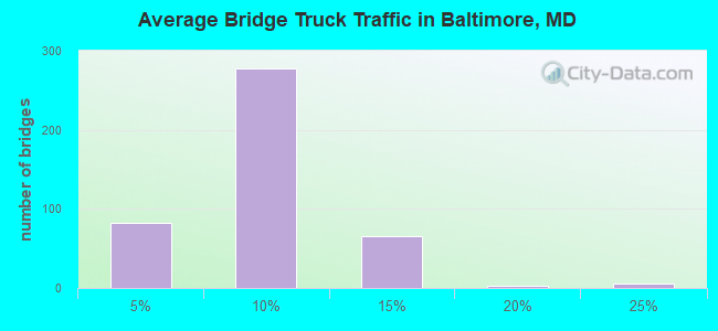
- 14,623,220Total average daily traffic
- 904,848Total average daily truck traffic
- National Bridge Inventory (NBI) Registered Bridges for Baltimore
- No street view available for this location
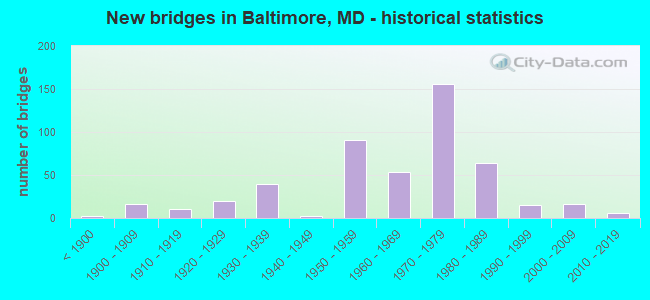
- New bridges - historical statistics
- 2Before 1900
- 161900-1909
- 111910-1919
- 201920-1929
- 391930-1939
- 21940-1949
- 911950-1959
- 541960-1969
- 1561970-1979
- 641980-1989
- 151990-1999
- 162000-2009
- 62010-2019
- 12020-2022
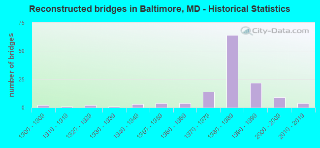
- Reconstructed bridges - Historical Statistics
- 21900-1909
- 11910-1919
- 21920-1929
- 11930-1939
- 31940-1949
- 41950-1959
- 41960-1969
- 141970-1979
- 641980-1989
- 221990-1999
- 92000-2009
- 42010-2019

- Bridge Condition - Deck
- 2.1%Very good
- 48.6%Good
- 34.5%Satisfactory
- 11.1%Fair
- 3.0%Poor
- 0.6%Serious
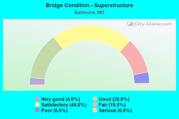
- Bridge Condition - Superstructure
- 4.0%Very good
- 25.6%Good
- 44.0%Satisfactory
- 19.5%Fair
- 6.0%Poor
- 0.9%Serious
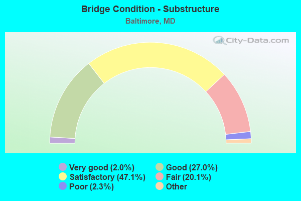
- Bridge Condition - Substructure
- 2.0%Very good
- 27.0%Good
- 47.1%Satisfactory
- 20.1%Fair
- 2.3%Poor
- 1.4%Serious
- 0.9%Critical
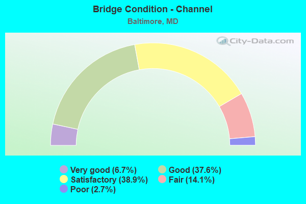
- Bridge Condition - Channel
- 6.7%Very good
- 37.6%Good
- 38.9%Satisfactory
- 14.1%Fair
- 2.7%Poor
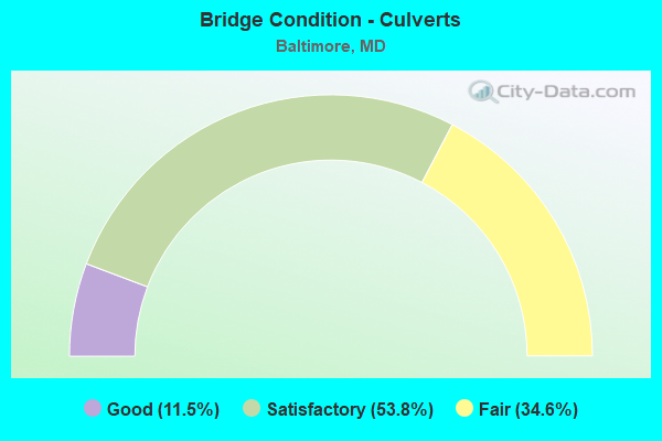
- Bridge Condition - Culverts
- 11.5%Good
- 53.8%Satisfactory
- 34.6%Fair
Find on map >> Show street view
Structure Number: 300000BCY12501, Location: Milepost M12.5 (Lat: 0.654739, Lng: -1.275867), Route carried "under" structure: Interstate 895, Year Built: 1957, Structure Length: 0. m, Average Daily Traffic: 62,200 (year 2010), Truck Traffic: 2%, Features Intersected: IS 895, Facility Carried by Structure: FOSTER AVENUE
Minimum Vertical Clearance: 6.40m (21.00ft), Kilometerpoint: 8.962, Lanes on structure: 4, Lanes under structure: 2, Toll: On toll road, Material/Design: Steel, Design/Construction: Stringer/Multi-beam, Length of Maximum Span: 24.4m (80.1ft)
Find on map >> Show street view
Structure Number: 300000BCY12601, Location: Milepost M12.6 (Lat: 0.654739, Lng: -1.275867), Route carried "under" structure: Interstate 895, Year Built: 1957, Structure Length: 0. m, Average Daily Traffic: 62,200 (year 2010), Truck Traffic: 2%, Features Intersected: IS 895, Facility Carried by Structure: FLEET STREET
Minimum Vertical Clearance: 4.27m (14.01ft), Kilometerpoint: 9.075, Lanes on structure: 4, Lanes under structure: 2, Toll: On toll road, Material/Design: Steel, Design/Construction: Stringer/Multi-beam, Length of Maximum Span: 24.4m (80.1ft)
Find on map >> Show street view
Structure Number: 300000BCY12701, Location: Milepost M12.7 (Lat: 0.654756, Lng: -1.275867), Route carried "under" structure: Interstate 895, Year Built: 1957, Structure Length: 0. m, Average Daily Traffic: 62,200 (year 2010), Truck Traffic: 2%, Features Intersected: IS 895, Facility Carried by Structure: EASTERN AVENUE
Minimum Vertical Clearance: 4.57m (14.99ft), Kilometerpoint: 9.155, Lanes on structure: 4, Lanes under structure: 5, Toll: On toll road, Material/Design: Steel, Design/Construction: Stringer/Multi-beam, Length of Maximum Span: 28.0m (91.9ft)
Find on map >> Show street view
Structure Number: 300000BCY12901, Location: Milepost M12.9 (Lat: 0.654806, Lng: -1.275867), Route carried "under" structure: City street 952, Year Built: 1957, Structure Length: 0. m, Average Daily Traffic: 41,325 (year 2010), Features Intersected: LOMBARD STREET, Facility Carried by Structure: IS 895
Minimum Vertical Clearance: 4.27m (14.01ft), Kilometerpoint: 2.333, Lanes on structure: 4, Lanes under structure: 4, Material/Design: Steel, Design/Construction: Stringer/Multi-beam, Length of Maximum Span: 26.8m (87.9ft)
Find on map >> Show street view
Structure Number: 300000BCY133013, Location: Milepost M13.3 (Lat: 0.654872, Lng: -1.275706), Route carried "under" structure: Interstate 895, Year Built: 1957, Structure Length: 0. m, Average Daily Traffic: 61,050 (year 2010), Truck Traffic: 2%, Features Intersected: IS 895, Facility Carried by Structure: ERDMAN AVE EB
Minimum Vertical Clearance: 5.18m (16.99ft), Kilometerpoint: 10.748, Lanes on structure: 4, Lanes under structure: 4, Toll: On toll road, Material/Design: Steel, Design/Construction: Stringer/Multi-beam, Length of Maximum Span: 17.1m (56.1ft)
Find on map >> Show street view
Structure Number: 300000BCY133014, Location: Milepost M13.3 (Lat: 0.654872, Lng: -1.275706), Route carried "under" structure: Interstate 895, Year Built: 1957, Structure Length: 0. m, Average Daily Traffic: 61,050 (year 2010), Truck Traffic: 2%, Features Intersected: IS 895, Facility Carried by Structure: ERDMAN AVE WB
Minimum Vertical Clearance: 5.18m (16.99ft), Kilometerpoint: 10.780, Lanes on structure: 4, Lanes under structure: 3, Toll: On toll road, Material/Design: Steel, Design/Construction: Stringer/Multi-beam, Length of Maximum Span: 20.7m (67.9ft)
Find on map >> Show street view
Structure Number: 300000BCY13401, Location: Milepost M13.4 (Lat: 0.655000, Lng: -1.275689), Route carried "under" structure: Interstate 895, Year Built: 1957, Structure Length: 0. m, Average Daily Traffic: 61,050 (year 2010), Truck Traffic: 2%, Features Intersected: IS 895, Facility Carried by Structure: MAPLETON PLACE
Minimum Vertical Clearance: 5.18m (16.99ft), Kilometerpoint: 10.893, Lanes on structure: 5, Lanes under structure: 2, Toll: On toll road, Material/Design: Steel, Design/Construction: Girder and Floorbeam System, Length of Maximum Span: 36.6m (120.1ft)
Find on map >> Show street view
Structure Number: 300000BCY13501, Location: Milepost M13.5 (Lat: 0.655033, Lng: -1.275689), Route carried "under" structure: Interstate 895, Year Built: 1957, Structure Length: 0. m, Average Daily Traffic: 61,050 (year 2010), Truck Traffic: 2%, Features Intersected: IS 895, Facility Carried by Structure: US 40(PULASKI HWY)
Minimum Vertical Clearance: 4.27m (14.01ft), Kilometerpoint: 11.070, Lanes on structure: 4, Lanes under structure: 4, Toll: On toll road, Material/Design: Steel, Design/Construction: Stringer/Multi-beam, Length of Maximum Span: 20.7m (67.9ft)
Find on map >> Show street view
Structure Number: 300000BCY14101, Location: 0.62 MI S OF IS 95 (Lat: 0.655100, Lng: -1.275639), Route carried "under" structure: Interstate 895, Year Built: 1958, Structure Length: 0. m, Average Daily Traffic: 47,300 (year 2010), Truck Traffic: 3%, Features Intersected: IS 895, Facility Carried by Structure: MORAVIA ROAD
Minimum Vertical Clearance: 4.88m (16.01ft), Kilometerpoint: 12.068, Lanes on structure: 6, Lanes under structure: 7, Toll: On toll road, Material/Design: Steel, Design/Construction: Stringer/Multi-beam, Length of Maximum Span: 29.0m (95.1ft)
Find on map >> Show street view
Structure Number: 300000BCY14401, Location: Milepost M14.4 (Lat: 0.655133, Lng: -1.275606), Route carried "under" structure: Interstate 895, Year Built: 1957, Structure Length: 0. m, Average Daily Traffic: 60,300 (year 2010), Truck Traffic: 3%, Features Intersected: IS 895, Facility Carried by Structure: MORAVIA PARK DRIVE
Minimum Vertical Clearance: 4.88m (16.01ft), Kilometerpoint: 12.518, Lanes on structure: 6, Lanes under structure: 3, Toll: On toll road, Material/Design: Steel, Design/Construction: Stringer/Multi-beam, Length of Maximum Span: 23.2m (76.1ft)
Find on map >> Show street view
Structure Number: 300000BCZ50101, Location: 0.74 MI N OF CHEMICAL RD (Lat: 0.653383, Lng: -1.275933), Route carried "under" structure: State highway 695, Year Built: 1972, Structure Length: 0. m, Average Daily Traffic: 14,275 (year 2010), Truck Traffic: 5%, Features Intersected: MD 695, Facility Carried by Structure: QUARANTINE ROAD
Minimum Vertical Clearance: 4.88m (16.01ft), Kilometerpoint: 3.057, Lanes on structure: 4, Lanes under structure: 2, Toll: On toll road, Material/Design: Steel continuous, Design/Construction: Stringer/Multi-beam, Length of Maximum Span: 32.6m (107.0ft)