Bridge Statistics for Barling, Arkansas (AR)
Condition, Traffic, Stress, Structural Evaluation, Project Costs
- National Bridge Inventory (NBI) Statistics
- 36Number of bridges
- 436ft / 133mTotal length
- $1,671,000Total costs
- 172,741Total average daily traffic
- 16,714Total average daily truck traffic
- National Bridge Inventory (NBI) Registered Bridges for Barling
- No street view available for this location
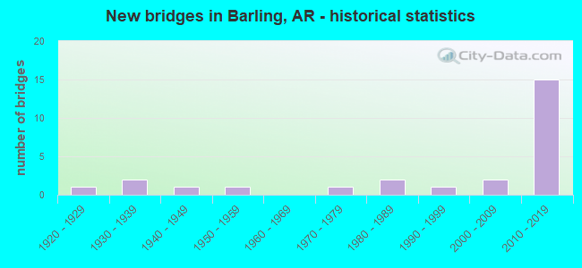
- New bridges - historical statistics
- 11920-1929
- 21930-1939
- 11940-1949
- 11950-1959
- 11970-1979
- 21980-1989
- 11990-1999
- 22000-2009
- 152010-2019
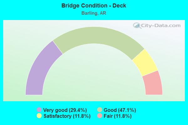
- Bridge Condition - Deck
- 29.4%Very good
- 47.1%Good
- 11.8%Satisfactory
- 11.8%Fair
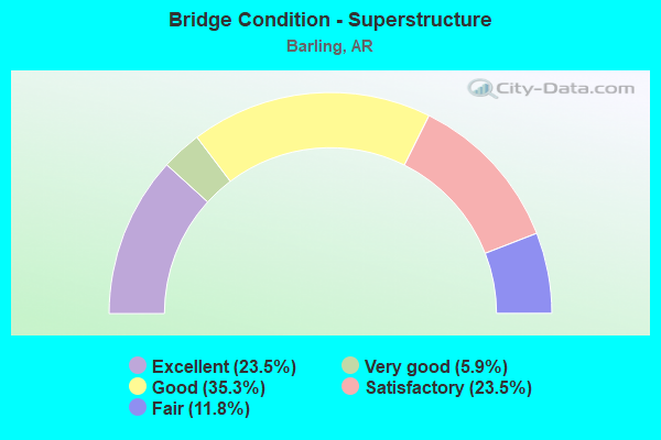
- Bridge Condition - Superstructure
- 23.5%Excellent
- 5.9%Very good
- 35.3%Good
- 23.5%Satisfactory
- 11.8%Fair
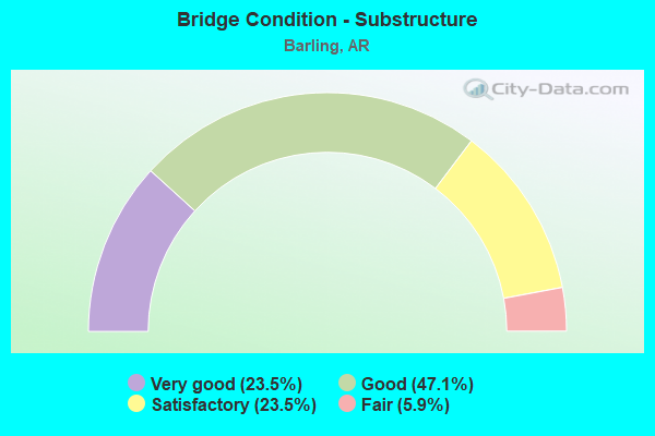
- Bridge Condition - Substructure
- 23.5%Very good
- 47.1%Good
- 23.5%Satisfactory
- 5.9%Fair
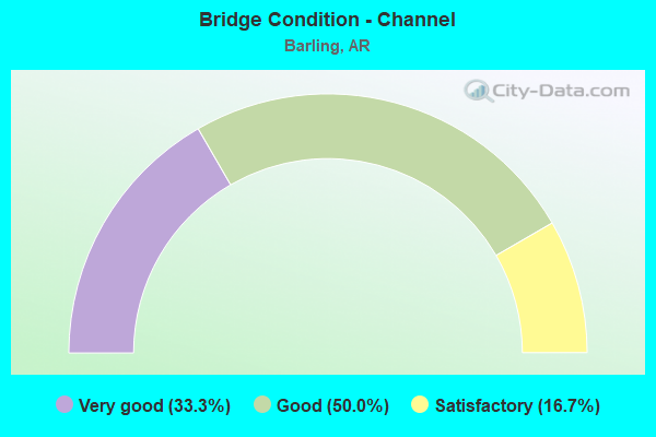
- Bridge Condition - Channel
- 33.3%Very good
- 50.0%Good
- 16.7%Satisfactory
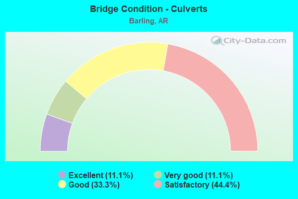
- Bridge Condition - Culverts
- 11.1%Excellent
- 11.1%Very good
- 33.3%Good
- 44.4%Satisfactory
Find on map >> Show street view
Structure Number: 2377, Location: 0.63 Mi E US 167-Sheridan (Lat: 34.307311, Lng: -92.388261), Route carried "on" structure: US 270, Year Built: 1948, Status: Open, Structure Length: 3.35m (10.99ft), Average Daily Traffic: 8,700 (year 2018), Truck Traffic: 11%, Average Future Daily Traffic: 10,549 (year 2028), Design Load: H 20, Features Intersected: Little Creek
Minimum Vertical Clearance: 30+ m (98+ ft), Kilometerpoint: 1.014, Lanes on structure: 2, Base Highway Network: Yes, Owner: State Highway Agency, Approaching Roadway Width: 9.1m (29.9ft), Material/Design: Steel, Design/Construction: Stringer/Multi-beam, Number Of Spans In Main Unit: 3, Length of Maximum Span: 11.0m (36.1ft), Curb or Sidewalk Widths: Left: 0.6m (2.0ft), Right: 0.6m (2.0ft), Curb-To-Curb Width: 7.9m (25.9ft), Out-to-Out Width: 9.8m (32.2ft)
Condition: Deck: Good, Superstructure: Fair, Substructure: Good, Channel: Good, Operating Rating: 41.7 metric tons, Method Used To Determine Operating Rating: Load Factor (LF), Inventory Rating: 24.5 metric tons, Method Used To Determine Inventory Rating: Load Factor (LF), Structural Evaluation: Somewhat better than minimum adequacy, Deck Geometry: High priority of replacement, Waterway Adequacy: Equal to present desirable criteria, Approach Roadway Alignment: Better than present minimum criteria, Length Of Structure Improvement: 4.18m (13.71ft), Designated Inspection Frequency: Every 24 months, Critical Feature Inspection Frequency: Every 24 months, Inspection Date: August 2020, Roadway Improvement Cost: $400,000, Total Project Cost: $974,000, Deck Structure Type: Concrete Cast-file-Place, Wearing Surface/Protective System: Wearing Surface: Bituminous
Find on map >> Show street view
Structure Number: 7048, Location: NW EDGE OF FT. CHAFFEE (Lat: 35.320128, Lng: -94.289758), Route carried "on" structure: State highway 22, Year Built: 2008, Status: Open, Structure Length: 3.38m (11.09ft), Average Daily Traffic: 16,000 (year 2018), Truck Traffic: 4%, Average Future Daily Traffic: 21,086 (year 2028), Design Load: HS 20, Features Intersected: Little Vache Cr Seb. Co.
Minimum Vertical Clearance: 30+ m (98+ ft), Kilometerpoint: 14.307, Lanes on structure: 2, Base Highway Network: Yes, Owner: State Highway Agency, Approaching Roadway Width: 22.9m (75.1ft), Skew: 3 degrees, Material/Design: Steel, Design/Construction: Stringer/Multi-beam, Number Of Spans In Main Unit: 3, Length of Maximum Span: 11.3m (37.1ft), Curb-To-Curb Width: 22.9m (75.1ft), Out-to-Out Width: 23.8m (78.1ft)
Condition: Deck: Good, Superstructure: Good, Substructure: Good, Channel: Very good, Operating Rating: 54.4 metric tons, Method Used To Determine Operating Rating: Load Factor (LF), Inventory Rating: 32.7 metric tons, Method Used To Determine Inventory Rating: Load Factor (LF), Structural Evaluation: Better than present minimum criteria, Deck Geometry: Superior to present desirable criteria, Waterway Adequacy: Equal to present desirable criteria, Approach Roadway Alignment: Equal to present desirable criteria, Designated Inspection Frequency: Every 24 months, Critical Feature Inspection Frequency: Every 24 months, Inspection Date: April 2020, Deck Structure Type: Concrete Cast-file-Place, Wearing Surface/Protective System: Wearing Surface: Monolithic Concrete, Deck Protection: Epoxy Coated Reinforcing
Find on map >> Show street view
Structure Number: 7063, Location: 1.0 S. of Wells Lk Rd. (Lat: 35.309469, Lng: -94.314469), Route carried "on" structure: City street 49340, Year Built: 2012, Status: Open, Structure Length: 11.31m (37.11ft), Average Daily Traffic: 760 (year 2012), Truck Traffic: 1%, Average Future Daily Traffic: 1,100 (year 2038), Design Load: HS 20, Features Intersected: SH 549 - Sebastian Co., Facility Carried by Structure: Roberts Boulevard
Minimum Vertical Clearance: 30+ m (98+ ft), Kilometerpoint: 1.642, Lanes on structure: 3, Lanes under structure: 4, Owner: State Highway Agency, Approaching Roadway Width: 22.9m (75.1ft), Skew: 4 degrees, Material/Design: Prestressed concrete, Design/Construction: Stringer/Multi-beam, Number Of Spans In Main Unit: 4, Length of Maximum Span: 38.4m (126.0ft), Curb-To-Curb Width: 22.8m (74.8ft), Out-to-Out Width: 23.8m (78.1ft)
Condition: Deck: Good, Superstructure: Satisfactory, Substructure: Good, Operating Rating: 54.4 metric tons, Method Used To Determine Operating Rating: Load Factor (LF), Inventory Rating: 32.7 metric tons, Method Used To Determine Inventory Rating: Load Factor (LF), Structural Evaluation: Equal to present minimum criteria, Deck Geometry: Superior to present desirable criteria, Underclear: Equal to present desirable criteria, Approach Roadway Alignment: Equal to present desirable criteria, Designated Inspection Frequency: Every 24 months, Critical Feature Inspection Frequency: Every 24 months, Inspection Date: October 2020, Deck Structure Type: Concrete Cast-file-Place, Wearing Surface/Protective System: Wearing Surface: Monolithic Concrete, Deck Protection: Epoxy Coated Reinforcing
Find on map >> Show street view
Structure Number: 7081, Location: 2.4 Mi So Jct Hwy 255 (Lat: 35.293658, Lng: -94.330117), Route carried "on" structure: City street 36490, Year Built: 2012, Status: Open, Structure Length: 8.54m (28.02ft), Average Daily Traffic: 5,300 (year 2018), Truck Traffic: 2%, Average Future Daily Traffic: 2,754 (year 2007), Design Load: HS 20, Features Intersected: SH 549 Sebastian Co., Facility Carried by Structure: Massard Road
Minimum Vertical Clearance: 30+ m (98+ ft), Kilometerpoint: 6.840, Lanes on structure: 2, Lanes under structure: 4, Owner: State Highway Agency, Approaching Roadway Width: 22.9m (75.1ft), Material/Design: Prestressed concrete continuous, Design/Construction: Stringer/Multi-beam, Number Of Spans In Main Unit: 4, Length of Maximum Span: 29.6m (97.1ft), Curb-To-Curb Width: 22.8m (74.8ft), Out-to-Out Width: 23.8m (78.1ft)
Condition: Deck: Good, Superstructure: Very good, Substructure: Good, Operating Rating: 54.4 metric tons, Method Used To Determine Operating Rating: Load Factor (LF), Inventory Rating: 32.7 metric tons, Method Used To Determine Inventory Rating: Load Factor (LF), Structural Evaluation: Better than present minimum criteria, Deck Geometry: Superior to present desirable criteria, Underclear: Better than present minimum criteria, Approach Roadway Alignment: Equal to present desirable criteria, Designated Inspection Frequency: Every 24 months, Critical Feature Inspection Frequency: Every 24 months, Inspection Date: October 2020, Deck Structure Type: Concrete Cast-file-Place, Wearing Surface/Protective System: Wearing Surface: Monolithic Concrete, Deck Protection: Epoxy Coated Reinforcing
Find on map >> Show street view
Structure Number: 22042, Location: 0.56 MI NE OF SH 22 (Lat: 35.332572, Lng: -94.300508), Route carried "on" structure: City street 24190, Year Built: 1989, Status: Open, Structure Length: 0.76m (2.49ft), Average Daily Traffic: 3,300 (year 2018), Truck Traffic: 1%, Average Future Daily Traffic: 329 (year 2019), Features Intersected: Creek - Seb. Co., Facility Carried by Structure: 'H' Street
Minimum Vertical Clearance: 30+ m (98+ ft), Kilometerpoint: 0.901, Lanes on structure: 2, Owner: City or Municipal Highway Agency, Approaching Roadway Width: 6.1m (20.0ft), Skew: 3 degrees, Material/Design: Concrete, Design/Construction: Culvert, Number Of Spans In Main Unit: 2, Length of Maximum Span: 3.1m (10.2ft), Curb or Sidewalk Widths: Left: 1.8m (5.9ft), Right: 0.3m (1.0ft), Curb-To-Curb Width: 10.8m (35.4ft), Out-to-Out Width: 16.0m (52.5ft)
Condition: Channel: Good, Culverts: Good, Operating Rating: 41.7 metric tons, Method Used To Determine Operating Rating: Load Factor (LF), Inventory Rating: 25.4 metric tons, Method Used To Determine Inventory Rating: Load Factor (LF), Structural Evaluation: Equal to present minimum criteria, Deck Geometry: Somewhat better than minimum adequacy, Waterway Adequacy: Better than present minimum criteria, Approach Roadway Alignment: Equal to present desirable criteria, Designated Inspection Frequency: Every 24 months, Critical Feature Inspection Frequency: Every 24 months, Inspection Date: September 2021, Deck Structure Type: Concrete Cast-file-Place, Wearing Surface/Protective System: Wearing Surface: Monolithic Concrete
Find on map >> Show street view
Structure Number: 22043, Location: 0.05 MI N OF 'H' STREET (Lat: 35.332981, Lng: -94.301164), Route carried "on" structure: City street 64510, Year Built: 1995, Status: Open, Structure Length: 0.77m (2.53ft), Average Daily Traffic: 1,125 (year 2018), Truck Traffic: 1%, Average Future Daily Traffic: 3,307 (year 2019), Features Intersected: Creek, Facility Carried by Structure: 5th Street - Seb.
Minimum Vertical Clearance: 30+ m (98+ ft), Kilometerpoint: 0.080, Lanes on structure: 2, Owner: City or Municipal Highway Agency, Approaching Roadway Width: 5.5m (18.0ft), Skew: 3 degrees, Material/Design: Concrete, Design/Construction: Culvert, Number Of Spans In Main Unit: 2, Length of Maximum Span: 3.9m (12.8ft), Curb or Sidewalk Widths: Left: 0.3m (1.0ft), Right: 1.8m (5.9ft), Curb-To-Curb Width: 7.8m (25.6ft), Out-to-Out Width: 10.1m (33.1ft)
Condition: Channel: Good, Culverts: Good, Operating Rating: 41.7 metric tons, Method Used To Determine Operating Rating: Load Factor (LF), Inventory Rating: 25.4 metric tons, Method Used To Determine Inventory Rating: Load Factor (LF), Structural Evaluation: Equal to present minimum criteria, Deck Geometry: Meets minimum limits, Waterway Adequacy: Better than present minimum criteria, Approach Roadway Alignment: Equal to present desirable criteria, Designated Inspection Frequency: Every 24 months, Critical Feature Inspection Frequency: Every 24 months, Inspection Date: September 2021, Deck Structure Type: Concrete Cast-file-Place, Wearing Surface/Protective System: Wearing Surface: Monolithic Concrete
Find on map >> Show street view
Structure Number: 22475, Location: 0.5 EAST OF SH 59-7 (Lat: 35.319575, Lng: -94.287828), Route carried "on" structure: County highway , Year Built: 1927, Status: Open, Structure Length: 1.98m (6.50ft), Average Daily Traffic: 9 (year 2014), Truck Traffic: 1%, Average Future Daily Traffic: 33 (year 2033), Features Intersected: Little Vache Grasse Cr., Facility Carried by Structure: Co. Rd - Seb Co.
Minimum Vertical Clearance: 30+ m (98+ ft), Kilometerpoint: 0.080, Lanes on structure: 2, Owner: State Highway Agency, Approaching Roadway Width: 6.1m (20.0ft), Material/Design: Steel, Design/Construction: Stringer/Multi-beam, Number Of Spans In Main Unit: 2, Length of Maximum Span: 10.1m (33.1ft), Curb or Sidewalk Widths: Left: 0.5m (1.6ft), Right: 0.4m (1.3ft), Curb-To-Curb Width: 7.2m (23.6ft), Out-to-Out Width: 8.0m (26.2ft)
Condition: Deck: Satisfactory, Superstructure: Satisfactory, Substructure: Fair, Channel: Satisfactory, Operating Rating: 39.0 metric tons, Method Used To Determine Operating Rating: Load Factor (LF), Inventory Rating: 23.6 metric tons, Method Used To Determine Inventory Rating: Load Factor (LF), Structural Evaluation: Somewhat better than minimum adequacy, Deck Geometry: Somewhat better than minimum adequacy, Waterway Adequacy: Equal to present minimum criteria, Approach Roadway Alignment: Meets minimum limits, Length Of Structure Improvement: 2.74m (8.99ft), Designated Inspection Frequency: Every 24 months, Critical Feature Inspection Frequency: Every 24 months, Inspection Date: September 2021, Roadway Improvement Cost: $341,000, Total Project Cost: $697,000, Deck Structure Type: Concrete Cast-file-Place, Wearing Surface/Protective System: Wearing Surface: Monolithic Concrete
Find on map >> Show street view
Structure Number: 23217, Location: 2.78 Mi. E. of Hwy. 59 (Lat: 35.331600, Lng: -94.255300), Route carried "on" structure: State lands road 4, Year Built: 1950, Status: Open, Structure Length: 3.66m (12.01ft), Average Daily Traffic: 100 (year 2004), Truck Traffic: 1%, Average Future Daily Traffic: 120 (year 2024), Features Intersected: Little Vache Grasse Cr.
Minimum Vertical Clearance: 30+ m (98+ ft), Kilometerpoint: 4.474, Lanes on structure: 1, Owner: State Agenciy, Approaching Roadway Width: 3.7m (12.1ft), Material/Design: Steel, Design/Construction: Truss - Thru, Number Of Spans In Main Unit: 3, Length of Maximum Span: 14.7m (48.2ft), Curb-To-Curb Width: 3.8m (12.5ft), Out-to-Out Width: 4.1m (13.5ft)
Condition: Deck: Fair, Superstructure: Satisfactory, Substructure: Satisfactory, Channel: Very good, Operating Rating: 28.1 metric tons, Method Used To Determine Operating Rating: Load Factor (LF), Inventory Rating: 17.2 metric tons, Method Used To Determine Inventory Rating: Load Factor (LF), Structural Evaluation: Somewhat better than minimum adequacy, Deck Geometry: Meets minimum limits, Waterway Adequacy: Better than present minimum criteria, Approach Roadway Alignment: Equal to present desirable criteria, Designated Inspection Frequency: Every 24 months, Critical Feature Inspection Frequency: Every 24 months, Inspection Date: April 2020, Critical Feature Inspection Date: April 2021, Deck Structure Type: Wood or Timber, Wearing Surface/Protective System: Wearing Surface: Wood or Timber
Find on map >> Show street view
Structure Number: 23531, Location: 0.29 Mi S Jct 1st Ave (Lat: 35.282028, Lng: -94.301831), Route carried "on" structure: State lands road 48070, Year Built: 1939, Status: Closed, Structure Length: 0.73m (2.40ft), Average Daily Traffic: 100 (year 1984), Truck Traffic: 1%, Average Future Daily Traffic: 120 (year 2004), Features Intersected: Prair Creek BR 042, Facility Carried by Structure: Red Oak Road
Minimum Vertical Clearance: 30+ m (98+ ft), Kilometerpoint: 0.467, Lanes on structure: 2, Owner: State Agenciy, Approaching Roadway Width: 7.3m (24.0ft), Material/Design: Wood or Timber, Design/Construction: Stringer/Multi-beam, Number Of Spans In Main Unit: 2, Length of Maximum Span: 3.4m (11.2ft), Curb or Sidewalk Widths: Left: 0.2m (0.7ft), Right: 0.2m (0.7ft), Curb-To-Curb Width: 7.4m (24.3ft), Out-to-Out Width: 8.0m (26.2ft)
Condition: Deck: Satisfactory, Superstructure: Satisfactory, Substructure: Satisfactory, Channel: Good, Operating Rating: 19.1 metric tons, Method Used To Determine Operating Rating: Allowable Stress (AS), Inventory Rating: 13.6 metric tons, Method Used To Determine Inventory Rating: Allowable Stress (AS), Structural Evaluation: Meets minimum limits, Deck Geometry: Equal to present minimum criteria, Waterway Adequacy: Equal to present minimum criteria, Approach Roadway Alignment: Equal to present minimum criteria, Bridge Posting: Required (Relationship of Operating Rating to Maximum Legal Load: 20.0 - 29.9% below), Designated Inspection Frequency: Every 24 months, Critical Feature Inspection Frequency: Every 24 months, Other Special Inspection Frequency: Every 12 months, Inspection Date: March 2020, Other Special Inspection Date: March 2021, Deck Structure Type: Wood or Timber, Wearing Surface/Protective System: Wearing Surface: Wood or Timber
Find on map >> Show street view
Structure Number: 23532, Location: 0.29 Mi S Jct 1st Ave (Lat: 35.281528, Lng: -94.298111), Route carried "on" structure: State lands road 27790, Year Built: 1939, Status: Posted for load, Structure Length: 1.10m (3.61ft), Average Daily Traffic: 100 (year 1984), Truck Traffic: 1%, Average Future Daily Traffic: 120 (year 2004), Features Intersected: Prair Creek BR 043, Facility Carried by Structure: Range 20 Road
Minimum Vertical Clearance: 30+ m (98+ ft), Kilometerpoint: 0.467, Lanes on structure: 2, Owner: State Agenciy, Approaching Roadway Width: 7.3m (24.0ft), Material/Design: Concrete, Design/Construction: Slab, Number Of Spans In Main Unit: 3, Length of Maximum Span: 3.7m (12.1ft), Curb-To-Curb Width: 6.1m (20.0ft), Out-to-Out Width: 6.7m (22.0ft)
Condition: Deck: Fair, Superstructure: Fair, Substructure: Satisfactory, Channel: Good, Operating Rating: 24.5 metric tons, Method Used To Determine Operating Rating: Load Factor (LF), Inventory Rating: 14.5 metric tons, Method Used To Determine Inventory Rating: Load Factor (LF), Structural Evaluation: Meets minimum limits, Deck Geometry: Somewhat better than minimum adequacy, Waterway Adequacy: Equal to present minimum criteria, Approach Roadway Alignment: Equal to present desirable criteria, Designated Inspection Frequency: Every 24 months, Critical Feature Inspection Frequency: Every 24 months, Inspection Date: March 2020, Deck Structure Type: Concrete Cast-file-Place, Wearing Surface/Protective System: Wearing Surface: Monolithic Concrete
Find on map >> Show street view
Structure Number: 23773, Location: 0.10 mi west of Denise (Lat: 34.590933, Lng: -92.557744), Route carried "on" structure: City street 43760, Year Built: 2015, Status: Open, Structure Length: 0.62m (2.03ft), Average Daily Traffic: 226 (year 2018), Truck Traffic: 1%, Average Future Daily Traffic: 55 (year 2035), Features Intersected: Branch, Facility Carried by Structure: Pamela Drive
Minimum Vertical Clearance: 30+ m (98+ ft), Kilometerpoint: 0.161, Lanes on structure: 2, Owner: City or Municipal Highway Agency, Approaching Roadway Width: 8.2m (26.9ft), Skew: 1 degrees, Material/Design: Concrete, Design/Construction: Culvert, Number Of Spans In Main Unit: 3, Length of Maximum Span: 1.8m (5.9ft), Curb-To-Curb Width: 9.3m (30.5ft), Out-to-Out Width: 9.8m (32.2ft)
Condition: Channel: Very good, Culverts: Excellent, Operating Rating: 51.7 metric tons, Method Used To Determine Operating Rating: Load and Resistance Factor (LRFR), Inventory Rating: 32.7 metric tons, Method Used To Determine Inventory Rating: Load and Resistance Factor (LRFR), Structural Evaluation: Superior to present desirable criteria, Deck Geometry: Equal to present minimum criteria, Waterway Adequacy: Better than present minimum criteria, Approach Roadway Alignment: Equal to present desirable criteria, Designated Inspection Frequency: Every 24 months, Critical Feature Inspection Frequency: Every 24 months, Inspection Date: April 2021, Wearing Surface/Protective System: Wearing Surface: Bituminous
Find on map >> Show street view
Structure Number: 23775, Location: 0.04 S Shannon Hill Dr (Lat: 34.622761, Lng: -92.401369), Route carried "on" structure: City street 11590, Year Built: 2015, Status: Open, Structure Length: 0.70m (2.30ft), Average Daily Traffic: 198 (year 2018), Truck Traffic: 1%, Average Future Daily Traffic: 275 (year 2035), Features Intersected: Branch, Facility Carried by Structure: Clayton Drive
Minimum Vertical Clearance: 30+ m (98+ ft), Kilometerpoint: 0.064, Lanes on structure: 2, Owner: City or Municipal Highway Agency, Approaching Roadway Width: 6.6m (21.7ft), Skew: 3 degrees, Material/Design: Concrete, Design/Construction: Culvert, Number Of Spans In Main Unit: 2, Length of Maximum Span: 3.0m (9.8ft), Curb-To-Curb Width: 9.0m (29.5ft), Out-to-Out Width: 9.6m (31.5ft)
Condition: Channel: Satisfactory, Culverts: Very good, Operating Rating: 36.3 metric tons, Method Used To Determine Operating Rating: Load and Resistance Factor (LRFR), Inventory Rating: 22.7 metric tons, Method Used To Determine Inventory Rating: Load and Resistance Factor (LRFR), Structural Evaluation: Equal to present minimum criteria, Deck Geometry: Equal to present minimum criteria, Waterway Adequacy: Equal to present desirable criteria, Approach Roadway Alignment: Equal to present desirable criteria, Designated Inspection Frequency: Every 24 months, Critical Feature Inspection Frequency: Every 24 months, Inspection Date: October 2021
Find on map >> Show street view
Structure Number: 23776, Location: 1.2 mi W of SH 9 (Lat: 34.718069, Lng: -92.781381), Route carried "on" structure: County highway 72, Year Built: 2015, Status: Open, Structure Length: 0.94m (3.08ft), Average Daily Traffic: 226 (year 2018), Truck Traffic: 1%, Average Future Daily Traffic: 115 (year 2035), Features Intersected: Creek
Minimum Vertical Clearance: 30+ m (98+ ft), Kilometerpoint: 2.317, Lanes on structure: 2, Owner: County Highway Agency, Approaching Roadway Width: 7.5m (24.6ft), Material/Design: Concrete, Design/Construction: Channel Beam, Number Of Spans In Main Unit: 1, Length of Maximum Span: 8.4m (27.6ft), Curb or Sidewalk Widths: Left: 0.2m (0.7ft), Right: 0.2m (0.7ft), Curb-To-Curb Width: 7.5m (24.6ft), Out-to-Out Width: 7.7m (25.3ft)
Condition: Deck: Very good, Superstructure: Good, Substructure: Good, Channel: Very good, Operating Rating: 54.4 metric tons, Method Used To Determine Operating Rating: Load Factor (LF), Inventory Rating: 32.7 metric tons, Method Used To Determine Inventory Rating: Load Factor (LF), Structural Evaluation: Better than present minimum criteria, Deck Geometry: Somewhat better than minimum adequacy, Waterway Adequacy: Better than present minimum criteria, Approach Roadway Alignment: Equal to present desirable criteria, Designated Inspection Frequency: Every 24 months, Critical Feature Inspection Frequency: Every 24 months, Inspection Date: November 2021, Deck Structure Type: Concrete Precast Panels, Wearing Surface/Protective System: Wearing Surface: Monolithic Concrete
Find on map >> Show street view
Structure Number: 23968, Location: 100 Ft SW Jct Brittany Dr (Lat: 35.316211, Lng: -94.291461), Route carried "on" structure: City street 10150, Year Built: 1988, Status: Open, Structure Length: 2.53m (8.30ft), Average Daily Traffic: 1,600 (year 2018), Truck Traffic: 1%, Average Future Daily Traffic: 250 (year 2037), Features Intersected: Little Vache Grasse Cr, Facility Carried by Structure: Chaffee Blvd
Minimum Vertical Clearance: 30+ m (98+ ft), Kilometerpoint: 1.658, Lanes on structure: 2, Owner: City or Municipal Highway Agency, Approaching Roadway Width: 7.9m (25.9ft), Material/Design: Steel, Design/Construction: Stringer/Multi-beam, Number Of Spans In Main Unit: 3, Length of Maximum Span: 7.9m (25.9ft), Curb or Sidewalk Widths: Left: 1.2m (3.9ft), Right: 1.2m (3.9ft), Curb-To-Curb Width: 8.5m (27.9ft), Out-to-Out Width: 11.7m (38.4ft)
Condition: Deck: Good, Superstructure: Good, Substructure: Good, Channel: Good, Operating Rating: 54.4 metric tons, Method Used To Determine Operating Rating: Load Factor (LF), Inventory Rating: 32.7 metric tons, Method Used To Determine Inventory Rating: Load Factor (LF), Structural Evaluation: Better than present minimum criteria, Deck Geometry: Somewhat better than minimum adequacy, Waterway Adequacy: Equal to present minimum criteria, Approach Roadway Alignment: Equal to present minimum criteria, Designated Inspection Frequency: Every 24 months, Critical Feature Inspection Frequency: Every 24 months, Inspection Date: July 2021, Deck Structure Type: Concrete Cast-file-Place
Find on map >> Show street view
Structure Number: 24113, Location: .2 Mi N. Cedar Crnr. Rd. (Lat: 35.315700, Lng: -91.695100), Route carried "on" structure: County highway CR77, Year Built: 2018, Status: Open, Structure Length: 0.94m (3.08ft), Features Intersected: Adler Creek, Facility Carried by Structure: Donnie Stevens Rd
Minimum Vertical Clearance: 30+ m (98+ ft), Kilometerpoint: 3.798, Lanes on structure: 2, Owner: County Highway Agency, Approaching Roadway Width: 0.9m (3.0ft), Material/Design: Concrete, Design/Construction: Channel Beam, Number Of Spans In Main Unit: 1, Length of Maximum Span: 8.5m (27.9ft), Curb-To-Curb Width: 6.5m (21.3ft), Out-to-Out Width: 7.1m (23.3ft)
Condition: Deck: Good, Superstructure: Good, Substructure: Satisfactory, Channel: Good, Operating Rating: 39.0 metric tons, Method Used To Determine Operating Rating: Load Factor (LF), Inventory Rating: 23.6 metric tons, Method Used To Determine Inventory Rating: Load Factor (LF), Structural Evaluation: Equal to present minimum criteria, Deck Geometry: Somewhat better than minimum adequacy, Waterway Adequacy: Better than present minimum criteria, Approach Roadway Alignment: Equal to present desirable criteria, Designated Inspection Frequency: Every 24 months, Critical Feature Inspection Frequency: Every 24 months, Inspection Date: March 2022, Deck Structure Type: Concrete Precast Panels
Find on map >> Show street view
Structure Number: A7064, Location: 1.7 mi N of Custer Blvd. (Lat: 35.318619, Lng: -94.299381), Route carried "on" structure: State highway 549, Year Built: 2010, Status: Open, Structure Length: 6.01m (19.72ft), Average Daily Traffic: 1,400 (year 2018), Truck Traffic: 21%, Average Future Daily Traffic: 2,750 (year 2036), Design Load: HS 20+Mod, Features Intersected: Taylor Avenue Seb. Co.
Minimum Vertical Clearance: 30+ m (98+ ft), Kilometerpoint: 8.835, Lanes on structure: 2, Lanes under structure: 3, Owner: State Highway Agency, Approaching Roadway Width: 12.2m (40.0ft), Material/Design: Steel, Design/Construction: Stringer/Multi-beam, Number Of Spans In Main Unit: 3, Length of Maximum Span: 24.1m (79.1ft), Curb-To-Curb Width: 12.2m (40.0ft), Out-to-Out Width: 13.2m (43.3ft)
Condition: Deck: Very good, Superstructure: Excellent, Substructure: Very good, Operating Rating: 54.4 metric tons, Method Used To Determine Operating Rating: Load Factor (LF), Inventory Rating: 32.7 metric tons, Method Used To Determine Inventory Rating: Load Factor (LF), Structural Evaluation: Equal to present desirable criteria, Deck Geometry: Better than present minimum criteria, Underclear: Somewhat better than minimum adequacy, Approach Roadway Alignment: Equal to present desirable criteria, Designated Inspection Frequency: Every 24 months, Critical Feature Inspection Frequency: Every 24 months, Inspection Date: April 2020, Deck Structure Type: Concrete Cast-file-Place, Wearing Surface/Protective System: Wearing Surface: Monolithic Concrete, Deck Protection: Epoxy Coated Reinforcing
Find on map >> Show street view
Structure Number: A7065, Location: Jct Hwy 22 Sec 1 (Lat: 35.320800, Lng: -94.295211), Route carried "on" structure: State highway 549, Year Built: 2010, Status: Open, Structure Length: 27.30m (89.57ft), Average Daily Traffic: 1,550 (year 2018), Truck Traffic: 21%, Average Future Daily Traffic: 18,750 (year 2028), Design Load: HS 20, Features Intersected: SH22 & Ft. Smith RR
Minimum Vertical Clearance: 30+ m (98+ ft), Kilometerpoint: 9.302, Lanes on structure: 3, Lanes under structure: 6, Owner: State Highway Agency, Approaching Roadway Width: 12.2m (40.0ft), Skew: 3 degrees, Material/Design: Steel continuous, Design/Construction: Stringer/Multi-beam, Number Of Spans In Main Unit: 8, Length of Maximum Span: 48.5m (159.1ft), Curb-To-Curb Width: 14.6m (47.9ft), Out-to-Out Width: 15.6m (51.2ft)
Condition: Deck: Very good, Superstructure: Excellent, Substructure: Very good, Operating Rating: 54.4 metric tons, Method Used To Determine Operating Rating: Load Factor (LF), Inventory Rating: 32.7 metric tons, Method Used To Determine Inventory Rating: Load Factor (LF), Structural Evaluation: Equal to present desirable criteria, Deck Geometry: Meets minimum limits, Underclear: Equal to present minimum criteria, Approach Roadway Alignment: Equal to present desirable criteria, Designated Inspection Frequency: Every 24 months, Critical Feature Inspection Frequency: Every 24 months, Inspection Date: April 2020, Deck Structure Type: Concrete Cast-file-Place, Wearing Surface/Protective System: Wearing Surface: Monolithic Concrete, Deck Protection: Epoxy Coated Reinforcing
Find on map >> Show street view
Structure Number: A7082, Location: Sta. 2040+34.51 (Lat: 35.298189, Lng: -94.325281), Route carried "on" structure: State highway 549, Year Built: 2013, Status: Open, Structure Length: 9.54m (31.30ft), Average Daily Traffic: 2,300 (year 2018), Truck Traffic: 21%, Average Future Daily Traffic: 2,750 (year 2036), Design Load: HS 20+Mod, Features Intersected: Custer Blvd
Minimum Vertical Clearance: 30+ m (98+ ft), Kilometerpoint: 5.552, Lanes on structure: 3, Lanes under structure: 2, Owner: State Highway Agency, Approaching Roadway Width: 11.0m (36.1ft), Skew: 2 degrees, Material/Design: Prestressed concrete, Design/Construction: Stringer/Multi-beam, Number Of Spans In Main Unit: 4, Length of Maximum Span: 34.7m (113.8ft), Curb-To-Curb Width: 14.6m (47.9ft), Out-to-Out Width: 15.6m (51.2ft)
Condition: Deck: Good, Superstructure: Good, Substructure: Good, Operating Rating: 36.3 metric tons, Method Used To Determine Operating Rating: Load Factor (LF), Inventory Rating: 21.8 metric tons, Method Used To Determine Inventory Rating: Load Factor (LF), Structural Evaluation: Somewhat better than minimum adequacy, Deck Geometry: Meets minimum limits, Underclear: Superior to present desirable criteria, Approach Roadway Alignment: Equal to present desirable criteria, Designated Inspection Frequency: Every 24 months, Critical Feature Inspection Frequency: Every 24 months, Inspection Date: April 2021, Deck Structure Type: Concrete Cast-file-Place, Wearing Surface/Protective System: Wearing Surface: Monolithic Concrete, Deck Protection: Epoxy Coated Reinforcing
Find on map >> Show street view
Structure Number: B7064, Location: 1.7 mi N. of Custer Blvd. (Lat: 35.318389, Lng: -94.299181), Route carried "on" structure: State highway 549, Year Built: 2010, Status: Open, Structure Length: 6.01m (19.72ft), Average Daily Traffic: 1,400 (year 2018), Truck Traffic: 21%, Average Future Daily Traffic: 37,502 (year 2028), Design Load: HS 20+Mod, Features Intersected: Taylor Avenue Seb. Co.
Minimum Vertical Clearance: 30+ m (98+ ft), Kilometerpoint: 8.835, Lanes on structure: 2, Lanes under structure: 3, Owner: State Highway Agency, Approaching Roadway Width: 12.2m (40.0ft), Material/Design: Steel, Design/Construction: Stringer/Multi-beam, Number Of Spans In Main Unit: 3, Length of Maximum Span: 24.1m (79.1ft), Curb-To-Curb Width: 12.2m (40.0ft), Out-to-Out Width: 13.2m (43.3ft)
Condition: Deck: Very good, Superstructure: Excellent, Substructure: Very good, Operating Rating: 54.4 metric tons, Method Used To Determine Operating Rating: Load Factor (LF), Inventory Rating: 32.7 metric tons, Method Used To Determine Inventory Rating: Load Factor (LF), Structural Evaluation: Equal to present desirable criteria, Deck Geometry: Better than present minimum criteria, Underclear: Somewhat better than minimum adequacy, Approach Roadway Alignment: Equal to present desirable criteria, Designated Inspection Frequency: Every 24 months, Critical Feature Inspection Frequency: Every 24 months, Inspection Date: April 2020, Deck Structure Type: Concrete Cast-file-Place, Wearing Surface/Protective System: Wearing Surface: Monolithic Concrete, Deck Protection: Epoxy Coated Reinforcing
Find on map >> Show street view
Structure Number: B7065, Location: Jct Hwy 22 Sec 1 (Lat: 35.320581, Lng: -94.294900), Route carried "on" structure: State highway 549, Year Built: 2010, Status: Open, Structure Length: 28.64m (93.96ft), Average Daily Traffic: 1,550 (year 2017), Truck Traffic: 21%, Average Future Daily Traffic: 37,502 (year 2028), Design Load: HS 20, Features Intersected: SH22 & Ft. Smith RR
Minimum Vertical Clearance: 30+ m (98+ ft), Kilometerpoint: 9.302, Lanes on structure: 1, Lanes under structure: 6, Owner: State Highway Agency, Approaching Roadway Width: 12.2m (40.0ft), Skew: 3 degrees, Material/Design: Steel continuous, Design/Construction: Stringer/Multi-beam, Number Of Spans In Main Unit: 8, Length of Maximum Span: 48.5m (159.1ft), Curb-To-Curb Width: 14.6m (47.9ft), Out-to-Out Width: 15.6m (51.2ft)
Condition: Deck: Very good, Superstructure: Excellent, Substructure: Very good, Operating Rating: 54.4 metric tons, Method Used To Determine Operating Rating: Load Factor (LF), Inventory Rating: 32.7 metric tons, Method Used To Determine Inventory Rating: Load Factor (LF), Structural Evaluation: Equal to present desirable criteria, Deck Geometry: Superior to present desirable criteria, Underclear: Equal to present minimum criteria, Approach Roadway Alignment: Equal to present desirable criteria, Designated Inspection Frequency: Every 24 months, Critical Feature Inspection Frequency: Every 24 months, Inspection Date: April 2020, Deck Structure Type: Concrete Cast-file-Place, Wearing Surface/Protective System: Wearing Surface: Monolithic Concrete, Deck Protection: Epoxy Coated Reinforcing
Find on map >> Show street view
Structure Number: B7082, Location: 2.5 M S Jct SH 22 (Lat: 35.298039, Lng: -94.324919), Route carried "on" structure: State highway 549, Year Built: 2013, Status: Open, Structure Length: 9.54m (31.30ft), Average Daily Traffic: 2,300 (year 2018), Truck Traffic: 21%, Average Future Daily Traffic: 18,751 (year 2028), Design Load: HS 20+Mod, Features Intersected: Custer Blvd.
Minimum Vertical Clearance: 30+ m (98+ ft), Kilometerpoint: 5.552, Lanes on structure: 2, Lanes under structure: 2, Owner: State Highway Agency, Approaching Roadway Width: 11.0m (36.1ft), Skew: 2 degrees, Material/Design: Prestressed concrete, Design/Construction: Stringer/Multi-beam, Number Of Spans In Main Unit: 4, Length of Maximum Span: 34.7m (113.8ft), Curb-To-Curb Width: 14.6m (47.9ft), Out-to-Out Width: 15.6m (51.2ft)
Condition: Deck: Good, Superstructure: Good, Substructure: Good, Operating Rating: 36.3 metric tons, Method Used To Determine Operating Rating: Load Factor (LF), Inventory Rating: 21.8 metric tons, Method Used To Determine Inventory Rating: Load Factor (LF), Structural Evaluation: Somewhat better than minimum adequacy, Deck Geometry: Superior to present desirable criteria, Underclear: Superior to present desirable criteria, Approach Roadway Alignment: Equal to present desirable criteria, Designated Inspection Frequency: Every 24 months, Critical Feature Inspection Frequency: Every 24 months, Inspection Date: April 2021, Deck Structure Type: Concrete Cast-file-Place, Wearing Surface/Protective System: Wearing Surface: Monolithic Concrete, Deck Protection: Epoxy Coated Reinforcing
Find on map >> Show street view
Structure Number: X039, Location: 1.36 M S OF ARK RVR (Lat: 35.330550, Lng: -94.296311), Route carried "on" structure: State highway 59, Year Built: 1979, Status: Open, Structure Length: 0.80m (2.62ft), Average Daily Traffic: 7,749 (year 2018), Truck Traffic: 1%, Average Future Daily Traffic: 5,799 (year 2028), Design Load: H 20, Features Intersected: Creek - Sebastian County
Minimum Vertical Clearance: 30+ m (98+ ft), Kilometerpoint: 1.979, Lanes on structure: 2, Owner: State Highway Agency, Approaching Roadway Width: 12.2m (40.0ft), Material/Design: Concrete, Design/Construction: Culvert, Number Of Spans In Main Unit: 4, Length of Maximum Span: 2.1m (6.9ft)
Condition: Channel: Satisfactory, Culverts: Satisfactory, Operating Rating: 29.9 metric tons, Method Used To Determine Operating Rating: Load Factor (LF), Inventory Rating: 18.1 metric tons, Method Used To Determine Inventory Rating: Load Factor (LF), Structural Evaluation: Meets minimum limits, Waterway Adequacy: Equal to present desirable criteria, Approach Roadway Alignment: Equal to present desirable criteria, Designated Inspection Frequency: Every 24 months, Critical Feature Inspection Frequency: Every 24 months, Inspection Date: November 2021
Find on map >> Show street view
Structure Number: X1241, Location: 1.2 MI E Jct SH 22 & 59 (Lat: 35.316719, Lng: -94.276578), Route carried "on" structure: State highway 22, Year Built: 2010, Status: Open, Structure Length: 1.19m (3.90ft), Average Daily Traffic: 16,000 (year 2018), Truck Traffic: 4%, Average Future Daily Traffic: 20,300 (year 2038), Design Load: HS 20+Mod, Features Intersected: Creek Sebastian Co.
Minimum Vertical Clearance: 30+ m (98+ ft), Kilometerpoint: 15.482, Lanes on structure: 5, Owner: State Highway Agency, Approaching Roadway Width: 23.1m (75.8ft), Skew: 1 degrees, Material/Design: Concrete, Design/Construction: Culvert, Number Of Spans In Main Unit: 3, Length of Maximum Span: 3.4m (11.2ft)
Condition: Channel: Good, Culverts: Satisfactory, Operating Rating: 29.0 metric tons, Method Used To Determine Operating Rating: Load Factor (LF), Inventory Rating: 17.2 metric tons, Method Used To Determine Inventory Rating: Load Factor (LF), Structural Evaluation: Meets minimum limits, Waterway Adequacy: Equal to present desirable criteria, Approach Roadway Alignment: Equal to present minimum criteria, Designated Inspection Frequency: Every 24 months, Critical Feature Inspection Frequency: Every 24 months, Inspection Date: June 2020
Find on map >> Show street view
Structure Number: X1296, Location: 1.5 MI E Jct SH 22 & 59 (Lat: 35.316358, Lng: -94.271628), Route carried "on" structure: State highway 22, Year Built: 2010, Status: Open, Structure Length: 0.96m (3.15ft), Average Daily Traffic: 16,000 (year 2018), Truck Traffic: 4%, Average Future Daily Traffic: 20,300 (year 2038), Design Load: HS 20+Mod, Features Intersected: Creek Sebastian Co.
Minimum Vertical Clearance: 30+ m (98+ ft), Kilometerpoint: 15.933, Lanes on structure: 5, Owner: State Highway Agency, Approaching Roadway Width: 23.1m (75.8ft), Material/Design: Concrete, Design/Construction: Culvert, Number Of Spans In Main Unit: 3, Length of Maximum Span: 3.0m (9.8ft)
Condition: Channel: Very good, Culverts: Satisfactory, Operating Rating: 35.4 metric tons, Method Used To Determine Operating Rating: Load Factor (LF), Inventory Rating: 21.8 metric tons, Method Used To Determine Inventory Rating: Load Factor (LF), Structural Evaluation: Somewhat better than minimum adequacy, Waterway Adequacy: Equal to present desirable criteria, Approach Roadway Alignment: Equal to present minimum criteria, Designated Inspection Frequency: Every 24 months, Critical Feature Inspection Frequency: Every 24 months, Inspection Date: June 2020
Find on map >> Show street view
Structure Number: X1297, Location: 0.15 MI S SH 22 (Lat: 35.320500, Lng: -94.295914), Route carried "on" structure: State highway 549, Year Built: 2007, Status: Open, Structure Length: 0.98m (3.22ft), Average Daily Traffic: 3,096 (year 2017), Truck Traffic: 21%, Average Future Daily Traffic: 25,666 (year 2025), Design Load: H 20, Features Intersected: Branch, Ltl Vache Grasse
Minimum Vertical Clearance: 30+ m (98+ ft), Kilometerpoint: 9.222, Lanes on structure: 4, Owner: State Highway Agency, Approaching Roadway Width: 29.3m (96.1ft), Skew: 4 degrees, Material/Design: Concrete, Design/Construction: Culvert, Number Of Spans In Main Unit: 3, Length of Maximum Span: 3.2m (10.5ft)
Condition: Channel: Good, Culverts: Satisfactory, Operating Rating: 33.6 metric tons, Method Used To Determine Operating Rating: Load Factor (LF), Inventory Rating: 20.0 metric tons, Method Used To Determine Inventory Rating: Load Factor (LF), Structural Evaluation: Somewhat better than minimum adequacy, Waterway Adequacy: Equal to present desirable criteria, Approach Roadway Alignment: Equal to present desirable criteria, Designated Inspection Frequency: Every 24 months, Critical Feature Inspection Frequency: Every 24 months, Inspection Date: January 2021
Find on map >> Show street view
Structure Number: X1403, Location: 0.6 mi. S. of Massard Rd (Lat: 35.286664, Lng: -94.336450), Route carried "on" structure: State highway 549, Year Built: 2011, Status: Open, Structure Length: 0.76m (2.49ft), Average Daily Traffic: 4,578 (year 2018), Truck Traffic: 21%, Average Future Daily Traffic: 37,502 (year 2028), Design Load: HS 20+Mod, Features Intersected: Creek - Sebastian Co.
Minimum Vertical Clearance: 30+ m (98+ ft), Kilometerpoint: 3.927, Lanes on structure: 4, Owner: State Highway Agency, Approaching Roadway Width: 12.2m (40.0ft), Skew: 10 degrees, Material/Design: Concrete, Design/Construction: Culvert, Number Of Spans In Main Unit: 2, Length of Maximum Span: 3.8m (12.5ft)
Condition: Channel: Very good, Culverts: Good, Operating Rating: 41.7 metric tons, Method Used To Determine Operating Rating: Load Factor (LF), Inventory Rating: 25.4 metric tons, Method Used To Determine Inventory Rating: Load Factor (LF), Structural Evaluation: Equal to present minimum criteria, Waterway Adequacy: Equal to present desirable criteria, Approach Roadway Alignment: Equal to present desirable criteria, Designated Inspection Frequency: Every 24 months, Critical Feature Inspection Frequency: Every 24 months, Inspection Date: August 2021
Find on map >> Show street view
Structure Number: 7063, Location: 1.0 S. of Wells Lk Rd. (Lat: 35.309469, Lng: -94.314469), Route carried "under" structure: State highway 549, Structure Length: 0. m, Average Daily Traffic: 10,606 (year 2008), Truck Traffic: 21%, Features Intersected: SH 549, Facility Carried by Structure: Roberts Boulevard
Minimum Vertical Clearance: 5.23m (17.16ft), Kilometerpoint: 7.194, Length of Maximum Span: 0.0m
Find on map >> Show street view
Structure Number: 7063, Location: 1.0 S. of Wells Lk Rd. (Lat: 35.309469, Lng: -94.314469), Route carried "under" structure: State highway 549, Structure Length: 0. m, Average Daily Traffic: 10,606 (year 2008), Truck Traffic: 21%, Features Intersected: SH 549, Facility Carried by Structure: Roberts Boulevard
Minimum Vertical Clearance: 6.06m (19.88ft), Kilometerpoint: 7.194, Length of Maximum Span: 0.0m
Find on map >> Show street view
Structure Number: 7081, Location: 2.4 Mi So Jct Hwy 255 (Lat: 35.293658, Lng: -94.330117), Route carried "under" structure: State highway 549, Structure Length: 0. m, Average Daily Traffic: 10,606 (year 2008), Truck Traffic: 21%, Features Intersected: SH 549, Facility Carried by Structure: Massard Road
Minimum Vertical Clearance: 5.25m (17.22ft), Kilometerpoint: 4.892, Length of Maximum Span: 0.0m
Find on map >> Show street view
Structure Number: 7081, Location: 2.4 Mi So Jct Hwy 255 (Lat: 35.293658, Lng: -94.330117), Route carried "under" structure: State highway 549, Structure Length: 0. m, Average Daily Traffic: 10,606 (year 2008), Truck Traffic: 21%, Features Intersected: US 71 Relocation, Facility Carried by Structure: Massard Road
Minimum Vertical Clearance: 5.48m (17.98ft), Kilometerpoint: 4.892, Toll: On toll road, Length of Maximum Span: 0.0m
Find on map >> Show street view
Structure Number: A7064, Location: 1.7 mi N of Custer Blvd. (Lat: 35.318619, Lng: -94.299381), Route carried "under" structure: City street 57100, Structure Length: 0. m, Average Daily Traffic: 200 (year 2012), Truck Traffic: 1%, Features Intersected: Taylor Avenue, Facility Carried by Structure: SH 549 SB Lns
Minimum Vertical Clearance: 8.38m (27.49ft), Kilometerpoint: 2.816, Length of Maximum Span: 0.0m
Find on map >> Show street view
Structure Number: A7065, Location: Jct Hwy 22 Sec 1 (Lat: 35.320800, Lng: -94.295211), Route carried "under" structure: State highway 22, Structure Length: 0. m, Average Daily Traffic: 17,000 (year 2014), Truck Traffic: 1%, Features Intersected: Hwy 22 Sec 1, Facility Carried by Structure: SH 549, SB Lns
Minimum Vertical Clearance: 5.76m (18.90ft), Kilometerpoint: 13.921, Length of Maximum Span: 0.0m
Find on map >> Show street view
Structure Number: A7082, Location: Sta. 2040+34.51 (Lat: 35.298189, Lng: -94.325281), Route carried "under" structure: County highway 14295, Structure Length: 0. m, Average Daily Traffic: 100 (year 2013), Truck Traffic: 1%, Features Intersected: Custer Blvd., Facility Carried by Structure: SH 549, SB Lns
Minimum Vertical Clearance: 6.88m (22.57ft), Kilometerpoint: 1.062, Length of Maximum Span: 0.0m
Find on map >> Show street view
Structure Number: B7064, Location: 1.7 mi N. of Custer Blvd. (Lat: 35.318389, Lng: -94.299181), Route carried "under" structure: City street 57100, Structure Length: 0. m, Average Daily Traffic: 250 (year 2012), Truck Traffic: 1%, Features Intersected: Taylor Avenue, Facility Carried by Structure: SH 549, NB Lns
Minimum Vertical Clearance: 8.16m (26.77ft), Kilometerpoint: 2.816, Length of Maximum Span: 0.0m
Find on map >> Show street view
Structure Number: B7065, Location: Jct Hwy 22 Sec 1 (Lat: 35.320581, Lng: -94.294900), Route carried "under" structure: State highway 22, Structure Length: 0. m, Average Daily Traffic: 17,000 (year 2014), Truck Traffic: 4%, Features Intersected: Hwy 22 Sec 1, Facility Carried by Structure: SH 549, NB Lns
Minimum Vertical Clearance: 5.97m (19.59ft), Kilometerpoint: 13.969, Length of Maximum Span: 0.0m
Find on map >> Show street view
Structure Number: B7082, Location: 2.5 M S Jct SH 22 (Lat: 35.298039, Lng: -94.324919), Route carried "under" structure: County highway 14295, Structure Length: 0. m, Average Daily Traffic: 100 (year 2013), Truck Traffic: 1%, Features Intersected: Custer Blvd., Facility Carried by Structure: SH 549, NB Lns
Minimum Vertical Clearance: 7.25m (23.79ft), Kilometerpoint: 1.078, Length of Maximum Span: 0.0m