Bridge Statistics for Bedford, New York (NY)
Condition, Traffic, Stress, Structural Evaluation, Project Costs
- National Bridge Inventory (NBI) Statistics
- 14Number of bridges
- 92ft / 28.5mTotal length
- $25,064,000Total costs
- 216,945Total average daily traffic
- 8,237Total average daily truck traffic
- National Bridge Inventory (NBI) Registered Bridges for Bedford
- No street view available for this location
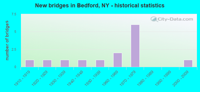
- New bridges - historical statistics
- 11910-1919
- 11920-1929
- 11930-1939
- 11940-1949
- 11950-1959
- 21960-1969
- 61970-1979
- 12000-2009
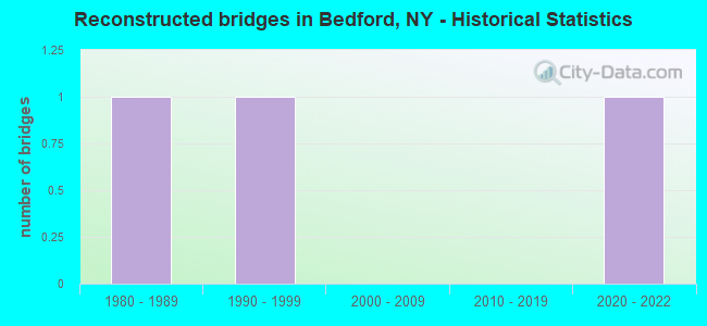
- Reconstructed bridges - Historical Statistics
- 11980-1989
- 11990-1999
- 02000-2009
- 02010-2019
- 12020-2022
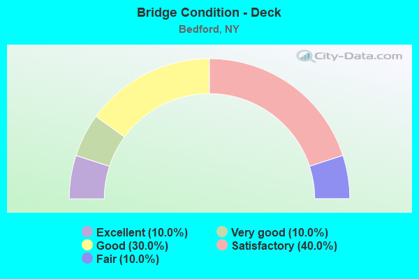
- Bridge Condition - Deck
- 10.0%Excellent
- 10.0%Very good
- 30.0%Good
- 40.0%Satisfactory
- 10.0%Fair
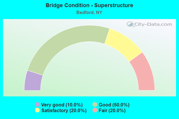
- Bridge Condition - Superstructure
- 10.0%Very good
- 50.0%Good
- 20.0%Satisfactory
- 20.0%Fair
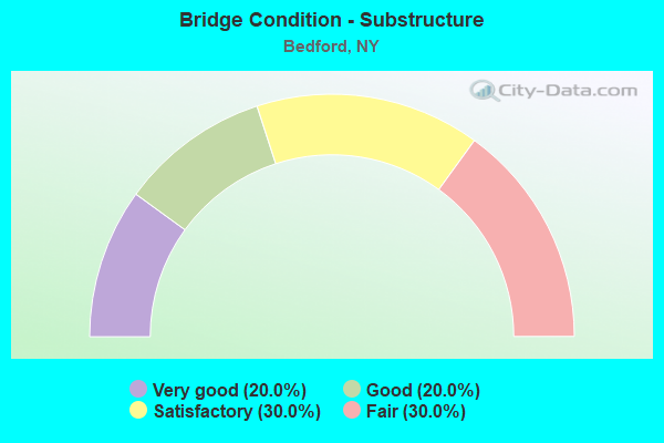
- Bridge Condition - Substructure
- 20.0%Very good
- 20.0%Good
- 30.0%Satisfactory
- 30.0%Fair
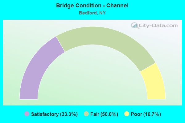
- Bridge Condition - Channel
- 33.3%Satisfactory
- 50.0%Fair
- 16.7%Poor
Find on map >> Show street view
Structure Number: 101659, Location: 3.0 MI S JCT RTS 22+172 (Lat: 41.226550, Lng: -73.656872), Route carried "on" structure: State highway 22, Year Built: 1927, Status: Posted for load-capacity, Structure Length: 1.07m (3.51ft), Average Daily Traffic: 4,143 (year 2017), Truck Traffic: 5%, Average Future Daily Traffic: 4,162 (year 2040), Design Load: H 20, Features Intersected: STONE HILL RIVER
Minimum Vertical Clearance: 30+ m (98+ ft), Kilometerpoint: 45.808, Lanes on structure: 2, Base Highway Network: Yes, Owner: State Highway Agency, Approaching Roadway Width: 7.6m (24.9ft), Skew: 2 degrees, Material/Design: Concrete, Design/Construction: Tee Beam, Number Of Spans In Main Unit: 1, Length of Maximum Span: 9.4m (30.8ft), Curb-To-Curb Width: 9.1m (29.9ft), Out-to-Out Width: 10.7m (35.1ft)
Condition: Deck: Good, Superstructure: Satisfactory, Substructure: Satisfactory, Channel: Poor, Operating Rating: 10.0 metric tons, Method Used To Determine Operating Rating: Load and Resistance Factor Rating (LRFR) rating reported by rating factor(RF) method using HL-93 loadings, Inventory Rating: 7.8 metric tons, Method Used To Determine Inventory Rating: Load and Resistance Factor Rating (LRFR) rating reported by rating factor(RF) method using HL-93 loadings, Structural Evaluation: High priority of corrective action, Deck Geometry: Meets minimum limits, Waterway Adequacy: Equal to present desirable criteria, Approach Roadway Alignment: Meets minimum limits, Length Of Structure Improvement: 1.06m (3.48ft), Designated Inspection Frequency: Every 24 months, Inspection Date: May 2020, Bridge Improvement Cost: $335,000, Roadway Improvement Cost: $196,000, Total Project Cost: $531,000 ( Estimate for 2021), Deck Structure Type: Concrete Cast-file-Place, Wearing Surface/Protective System: Wearing Surface: Bituminous
Find on map >> Show street view
Structure Number: 10374, Location: 1 MI NE JCT SH 22 & SH121 (Lat: 41.215781, Lng: -73.631947), Route carried "on" structure: State highway 121, Year Built: 2002, Status: Open, Structure Length: 1.55m (5.09ft), Average Daily Traffic: 4,107 (year 2017), Truck Traffic: 6%, Average Future Daily Traffic: 4,989 (year 2040), Design Load: HS 25 or greater, Features Intersected: STONE HILL RIVER
Minimum Vertical Clearance: 30+ m (98+ ft), Kilometerpoint: 1.609, Lanes on structure: 2, Base Highway Network: Yes, Owner: State Highway Agency, Approaching Roadway Width: 10.1m (33.1ft), Material/Design: Prestressed concrete, Design/Construction: Box Beam or Girders - Multiple, Number Of Spans In Main Unit: 1, Length of Maximum Span: 15.0m (49.2ft), Curb-To-Curb Width: 10.2m (33.5ft), Out-to-Out Width: 11.2m (36.7ft)
Condition: Deck: Very good, Superstructure: Very good, Substructure: Good, Channel: Satisfactory, Inventory Rating: 68.9 metric tons, Method Used To Determine Inventory Rating: Load Factor (LF), Structural Evaluation: Better than present minimum criteria, Deck Geometry: Meets minimum limits, Waterway Adequacy: Somewhat better than minimum adequacy, Approach Roadway Alignment: Equal to present desirable criteria, Length Of Structure Improvement: 1.55m (5.09ft), Designated Inspection Frequency: Every 24 months, Inspection Date: April 2020, Bridge Improvement Cost: $580,000, Roadway Improvement Cost: $340,000, Total Project Cost: $920,000 ( Estimate for 2021), Deck Structure Type: Concrete Cast-file-Place, Wearing Surface/Protective System: Wearing Surface: Integral Concrete, Deck Protection: Galvanized Reinforcing
Find on map >> Show street view
Structure Number: 105305, Location: 3.3 MI N EXIT 3 OF I684 (Lat: 41.181111, Lng: -73.685408), Route carried "on" structure: Other road , Year Built: 1971, Year Reconstructed: 2001, Status: Open, Structure Length: 7.35m (24.11ft), Average Daily Traffic: 47 (year 1997), Truck Traffic: 3%, Average Future Daily Traffic: 66 (year 2017), Design Load: HS 20, Features Intersected: 684I684I87011118 SB, RTE, Facility Carried by Structure: SANCTUARY CONNECT
Minimum Vertical Clearance: 30+ m (98+ ft), Kilometerpoint: 0.000, Lanes on structure: 2, Lanes under structure: 6, Owner: State Highway Agency, Approaching Roadway Width: 7.3m (24.0ft), Skew: 3 degrees, Material/Design: Steel, Design/Construction: Stringer/Multi-beam, Number Of Spans In Main Unit: 2, Length of Maximum Span: 39.3m (128.9ft), Curb-To-Curb Width: 9.5m (31.2ft), Out-to-Out Width: 10.5m (34.4ft)
Condition: Deck: Good, Superstructure: Good, Substructure: Satisfactory, Operating Rating: 95.2 metric tons, Method Used To Determine Operating Rating: Field evaluation and documented engineering judgment, Inventory Rating: 32.7 metric tons, Method Used To Determine Inventory Rating: Field evaluation and documented engineering judgment, Structural Evaluation: Equal to present minimum criteria, Deck Geometry: Better than present minimum criteria, Underclear: Somewhat better than minimum adequacy, Approach Roadway Alignment: Equal to present desirable criteria, Length Of Structure Improvement: 7.34m (24.08ft), Designated Inspection Frequency: Every 24 months, Inspection Date: June 2021, Bridge Improvement Cost: $3,169,000, Roadway Improvement Cost: $1,856,000, Total Project Cost: $5,024,000 ( Estimate for 2021), Deck Structure Type: Concrete Cast-file-Place, Wearing Surface/Protective System: Wearing Surface: Integral Concrete
Find on map >> Show street view
Structure Number: 1053071, Location: JCT RTS I684+172 (Lat: 41.195128, Lng: -73.686506), Route carried "on" structure: Interstate 684, Year Built: 1971, Status: Open, Structure Length: 3.90m (12.80ft), Average Daily Traffic: 29,979 (year 2000), Truck Traffic: 15%, Design Load: HS 20, Features Intersected: RTE 172
Minimum Vertical Clearance: 30+ m (98+ ft), Kilometerpoint: 20.386, Lanes on structure: 3, Lanes under structure: 5, Base Highway Network: Yes, Owner: State Highway Agency, Approaching Roadway Width: 15.5m (50.9ft), Skew: 2 degrees, Material/Design: Steel, Design/Construction: Stringer/Multi-beam, Number Of Spans In Main Unit: 1, Length of Maximum Span: 38.7m (127.0ft), Curb-To-Curb Width: 15.5m (50.9ft), Out-to-Out Width: 16.6m (54.5ft)
Condition: Deck: Satisfactory, Superstructure: Good, Substructure: Very good, Operating Rating: 95.3 metric tons, Method Used To Determine Operating Rating: Load Factor (LF), Inventory Rating: 57.2 metric tons, Method Used To Determine Inventory Rating: Load Factor (LF), Structural Evaluation: Better than present minimum criteria, Deck Geometry: Somewhat better than minimum adequacy, Underclear: Meets minimum limits, Approach Roadway Alignment: Equal to present desirable criteria, Length Of Structure Improvement: 3.90m (12.80ft), Designated Inspection Frequency: Every 24 months, Inspection Date: June 2021, Bridge Improvement Cost: $3,326,000, Roadway Improvement Cost: $1,948,000, Total Project Cost: $5,273,000 ( Estimate for 2021), Deck Structure Type: Concrete Cast-file-Place, Wearing Surface/Protective System: Wearing Surface: Monolithic Concrete
Find on map >> Show street view
Structure Number: 1053072, Location: JCT RTS I684+172 (Lat: 41.194992, Lng: -73.686197), Route carried "on" structure: Interstate 684, Year Built: 1971, Status: Open, Structure Length: 3.90m (12.80ft), Average Daily Traffic: 27,992 (year 2020), Truck Traffic: 11%, Average Future Daily Traffic: 47,401 (year 2040), Design Load: HS 20, Features Intersected: RTE 172
Minimum Vertical Clearance: 30+ m (98+ ft), Kilometerpoint: 20.450, Lanes on structure: 3, Lanes under structure: 5, Base Highway Network: Yes, Owner: State Highway Agency, Approaching Roadway Width: 16.2m (53.1ft), Skew: 2 degrees, Material/Design: Steel, Design/Construction: Stringer/Multi-beam, Number Of Spans In Main Unit: 1, Length of Maximum Span: 38.7m (127.0ft), Curb-To-Curb Width: 15.5m (50.9ft), Out-to-Out Width: 16.7m (54.8ft)
Condition: Deck: Satisfactory, Superstructure: Good, Substructure: Very good, Operating Rating: 95.3 metric tons, Method Used To Determine Operating Rating: Load Factor (LF), Inventory Rating: 57.2 metric tons, Method Used To Determine Inventory Rating: Load Factor (LF), Structural Evaluation: Better than present minimum criteria, Deck Geometry: Somewhat better than minimum adequacy, Underclear: Equal to present minimum criteria, Approach Roadway Alignment: Equal to present desirable criteria, Length Of Structure Improvement: 3.90m (12.80ft), Designated Inspection Frequency: Every 24 months, Inspection Date: June 2021, Bridge Improvement Cost: $3,446,000, Roadway Improvement Cost: $2,018,000, Total Project Cost: $5,463,000 ( Estimate for 2021), Deck Structure Type: Concrete Cast-file-Place, Wearing Surface/Protective System: Wearing Surface: Monolithic Concrete
Find on map >> Show street view
Structure Number: 105308, Location: 0.9 MI N JCT RTS I684+172 (Lat: 41.208306, Lng: -73.685419), Route carried "on" structure: Other road , Year Built: 1968, Year Reconstructed: 2020, Status: Open, Structure Length: 7.04m (23.10ft), Truck Traffic: 3%, Design Load: HS 20, Features Intersected: 684I684I87011137, RTE I6, Facility Carried by Structure: GUARD HILL ROAD
Minimum Vertical Clearance: 30+ m (98+ ft), Kilometerpoint: 2.397, Lanes on structure: 2, Lanes under structure: 6, Owner: State Highway Agency, Approaching Roadway Width: 9.8m (32.2ft), Skew: 1 degrees, Material/Design: Steel, Design/Construction: Stringer/Multi-beam, Number Of Spans In Main Unit: 2, Length of Maximum Span: 36.5m (119.8ft), Curb-To-Curb Width: 9.8m (32.2ft), Out-to-Out Width: 11.0m (36.1ft)
Condition: Deck: Excellent, Superstructure: Good, Substructure: Good, Operating Rating: 85.3 metric tons, Method Used To Determine Operating Rating: Load Factor (LF), Inventory Rating: 50.8 metric tons, Method Used To Determine Inventory Rating: Load Factor (LF), Structural Evaluation: Better than present minimum criteria, Deck Geometry: Equal to present desirable criteria, Underclear: Somewhat better than minimum adequacy, Approach Roadway Alignment: Equal to present desirable criteria, Length Of Structure Improvement: 7.04m (23.10ft), Designated Inspection Frequency: Every 24 months, Inspection Date: September 2020, Bridge Improvement Cost: $3,405,000, Roadway Improvement Cost: $1,994,000, Total Project Cost: $5,399,000 ( Estimate for 2021), Deck Structure Type: Concrete Cast-file-Place, Wearing Surface/Protective System: Wearing Surface: Integral Concrete, Deck Protection: Epoxy Coated Reinforcing
Find on map >> Show street view
Structure Number: 222491, Location: 4.6 MI NE OF MOUNT KISCO (Lat: 41.220156, Lng: -73.646808), Route carried "on" structure: Other road , Year Built: 1956, Status: Open, Structure Length: 0.79m (2.59ft), Average Daily Traffic: 352 (year 2017), Truck Traffic: 4%, Average Future Daily Traffic: 493 (year 2037), Features Intersected: BEAVER DAM CREEK, Facility Carried by Structure: HOOK ROAD
Minimum Vertical Clearance: 30+ m (98+ ft), Kilometerpoint: 2.076, Lanes on structure: 2, Owner: Town or Township Highway Agency, Approaching Roadway Width: 6.1m (20.0ft), Skew: 1 degrees, Material/Design: Concrete, Design/Construction: Slab, Number Of Spans In Main Unit: 1, Length of Maximum Span: 7.0m (23.0ft), Curb-To-Curb Width: 6.9m (22.6ft), Out-to-Out Width: 8.1m (26.6ft)
Condition: Deck: Satisfactory, Superstructure: Satisfactory, Substructure: Fair, Channel: Satisfactory, Operating Rating: 77.0 metric tons, Method Used To Determine Operating Rating: Field evaluation and documented engineering judgment, Inventory Rating: 29.4 metric tons, Method Used To Determine Inventory Rating: Field evaluation and documented engineering judgment, Structural Evaluation: Somewhat better than minimum adequacy, Deck Geometry: Meets minimum limits, Waterway Adequacy: Meets minimum limits, Approach Roadway Alignment: Better than present minimum criteria, Length Of Structure Improvement: 0.79m (2.59ft), Designated Inspection Frequency: Every 24 months, Inspection Date: March 2021, Bridge Improvement Cost: $361,000, Roadway Improvement Cost: $212,000, Total Project Cost: $573,000 ( Estimate for 2021), Wearing Surface/Protective System: Wearing Surface: Other
Find on map >> Show street view
Structure Number: 222492, Location: 5.1 MI E OF MOUNT KISCO (Lat: 41.201606, Lng: -73.632711), Route carried "on" structure: Other road , Year Built: 1941, Status: Open, Structure Length: 0.76m (2.49ft), Average Daily Traffic: 1,180 (year 2019), Truck Traffic: 4%, Average Future Daily Traffic: 1,652 (year 2039), Features Intersected: MIANUS RIVER, Facility Carried by Structure: MIDDLE PATENT RD
Minimum Vertical Clearance: 30+ m (98+ ft), Kilometerpoint: 0.080, Lanes on structure: 2, Owner: Town or Township Highway Agency, Approaching Roadway Width: 7.0m (23.0ft), Material/Design: Concrete, Design/Construction: Slab, Number Of Spans In Main Unit: 1, Length of Maximum Span: 7.0m (23.0ft), Curb-To-Curb Width: 7.3m (24.0ft), Out-to-Out Width: 8.4m (27.6ft)
Condition: Deck: Fair, Superstructure: Fair, Substructure: Fair, Channel: Fair, Operating Rating: 74.2 metric tons, Method Used To Determine Operating Rating: Field evaluation and documented engineering judgment, Inventory Rating: 29.4 metric tons, Method Used To Determine Inventory Rating: Field evaluation and documented engineering judgment, Structural Evaluation: Somewhat better than minimum adequacy, Deck Geometry: Meets minimum limits, Waterway Adequacy: Somewhat better than minimum adequacy, Approach Roadway Alignment: Equal to present desirable criteria, Length Of Structure Improvement: 0.76m (2.49ft), Designated Inspection Frequency: Every 24 months, Inspection Date: March 2021, Bridge Improvement Cost: $159,000, Roadway Improvement Cost: $93,000, Total Project Cost: $252,000 ( Estimate for 2021), Wearing Surface/Protective System: Wearing Surface: Bituminous
Find on map >> Show street view
Structure Number: 222493, Location: 5.5 MI E OF MOUNT KISCO (Lat: 41.194144, Lng: -73.624072), Route carried "on" structure: Other road , Year Built: 1930, Year Reconstructed: 1992, Status: Open, Structure Length: 1.28m (4.20ft), Average Daily Traffic: 105 (year 2015), Truck Traffic: 4%, Average Future Daily Traffic: 147 (year 2035), Design Load: HS 20, Features Intersected: MIANUS RIVER, Facility Carried by Structure: MILLERS MILL ROAD
Minimum Vertical Clearance: 30+ m (98+ ft), Kilometerpoint: 0.434, Lanes on structure: 2, Owner: Town or Township Highway Agency, Approaching Roadway Width: 7.3m (24.0ft), Material/Design: Steel, Design/Construction: Stringer/Multi-beam, Number Of Spans In Main Unit: 2, Length of Maximum Span: 6.1m (20.0ft), Curb-To-Curb Width: 6.1m (20.0ft), Out-to-Out Width: 6.9m (22.6ft)
Condition: Deck: Good, Superstructure: Good, Substructure: Fair, Channel: Fair, Operating Rating: 75.2 metric tons, Method Used To Determine Operating Rating: Load and Resistance Factor Rating (LRFR) rating reported by rating factor(RF) method using HL-93 loadings, Inventory Rating: 58.0 metric tons, Method Used To Determine Inventory Rating: Load and Resistance Factor Rating (LRFR) rating reported by rating factor(RF) method using HL-93 loadings, Structural Evaluation: Somewhat better than minimum adequacy, Deck Geometry: Meets minimum limits, Waterway Adequacy: Meets minimum limits, Approach Roadway Alignment: Somewhat better than minimum adequacy, Length Of Structure Improvement: 1.28m (4.20ft), Designated Inspection Frequency: Every 24 months, Inspection Date: March 2021, Bridge Improvement Cost: $761,000, Roadway Improvement Cost: $445,000, Total Project Cost: $1,206,000 ( Estimate for 2021), Deck Structure Type: Concrete Cast-file-Place, Wearing Surface/Protective System: Wearing Surface: Integral Concrete
Find on map >> Show street view
Structure Number: 334794, Location: 4.6 MI EAST OF MT KISCO (Lat: 41.195247, Lng: -73.643308), Route carried "on" structure: County highway , Year Built: 1919, Status: Open, Structure Length: 0.82m (2.69ft), Average Daily Traffic: 2,879 (year 2014), Truck Traffic: 5%, Average Future Daily Traffic: 3,562 (year 2040), Features Intersected: MIANUS RIVER, Facility Carried by Structure: GREENWICH ROAD
Minimum Vertical Clearance: 30+ m (98+ ft), Kilometerpoint: 5.004, Lanes on structure: 2, Owner: County Highway Agency, Approaching Roadway Width: 7.6m (24.9ft), Skew: 1 degrees, Material/Design: Concrete, Design/Construction: Slab, Number Of Spans In Main Unit: 1, Length of Maximum Span: 7.6m (24.9ft), Curb-To-Curb Width: 7.3m (24.0ft), Out-to-Out Width: 8.5m (27.9ft)
Condition: Deck: Satisfactory, Superstructure: Fair, Substructure: Satisfactory, Channel: Fair, Operating Rating: 52.6 metric tons, Method Used To Determine Operating Rating: Load Factor (LF), Inventory Rating: 29.9 metric tons, Method Used To Determine Inventory Rating: Load Factor (LF), Structural Evaluation: Somewhat better than minimum adequacy, Deck Geometry: High priority of replacement, Waterway Adequacy: Somewhat better than minimum adequacy, Approach Roadway Alignment: Equal to present desirable criteria, Length Of Structure Improvement: 0.82m (2.69ft), Designated Inspection Frequency: Every 24 months, Inspection Date: April 2021, Bridge Improvement Cost: $267,000, Roadway Improvement Cost: $156,000, Total Project Cost: $423,000 ( Estimate for 2021), Wearing Surface/Protective System: Wearing Surface: Bituminous
Find on map >> Show street view
Structure Number: 105305, Location: 3.3 MI N EXIT 3 OF I684 (Lat: 41.181111, Lng: -73.685408), Route carried "under" structure: Interstate 684, Year Built: 1971, Structure Length: 0. m, Average Daily Traffic: 62,545 (year 2002), Features Intersected: 684I684I87011118 SB, RTE, Facility Carried by Structure: SANCTUARY CONNECT
Minimum Vertical Clearance: 7.01m (23.00ft), Kilometerpoint: 18.874, Lanes on structure: 2, Lanes under structure: 3, Material/Design: Steel, Design/Construction: Stringer/Multi-beam, Length of Maximum Span: 39.3m (128.9ft)
Find on map >> Show street view
Structure Number: 1053071, Location: JCT RTS I684+172 (Lat: 41.195128, Lng: -73.686506), Route carried "under" structure: State highway 172, Year Built: 1971, Structure Length: 0. m, Average Daily Traffic: 12,500 (year 1972), Features Intersected: RTE 172, Facility Carried by Structure: RTE I684
Minimum Vertical Clearance: 5.38m (17.65ft), Kilometerpoint: 16.364, Lanes on structure: 3, Lanes under structure: 5, Material/Design: Steel, Design/Construction: Stringer/Multi-beam, Length of Maximum Span: 38.7m (127.0ft)
Find on map >> Show street view
Structure Number: 1053072, Location: JCT RTS I684+172 (Lat: 41.194992, Lng: -73.686197), Route carried "under" structure: State highway 172, Year Built: 1971, Structure Length: 0. m, Average Daily Traffic: 12,500 (year 1972), Features Intersected: RTE 172, Facility Carried by Structure: RTE I684
Minimum Vertical Clearance: 5.51m (18.08ft), Kilometerpoint: 16.364, Lanes on structure: 3, Lanes under structure: 5, Material/Design: Steel, Design/Construction: Stringer/Multi-beam, Length of Maximum Span: 38.7m (127.0ft)
Find on map >> Show street view
Structure Number: 105308, Location: 0.9 MI N JCT RTS I684+172 (Lat: 41.208306, Lng: -73.685419), Route carried "under" structure: Interstate 684, Year Built: 1968, Structure Length: 0. m, Average Daily Traffic: 58,616 (year 2002), Features Intersected: 684I684I87011137, RTE I6, Facility Carried by Structure: GUARD HILL ROAD
Minimum Vertical Clearance: 5.89m (19.32ft), Kilometerpoint: 21.947, Lanes on structure: 2, Lanes under structure: 3, Material/Design: Steel, Design/Construction: Stringer/Multi-beam, Length of Maximum Span: 36.5m (119.8ft)