Bridge Statistics for Beecher, Michigan (MI)
Condition, Traffic, Stress, Structural Evaluation, Project Costs
- National Bridge Inventory (NBI) Statistics
- 24Number of bridges
- 184ft / 56.0mTotal length
- $808,000Total costs
- 551,681Total average daily traffic
- 49,886Total average daily truck traffic
- National Bridge Inventory (NBI) Registered Bridges for Beecher
- No street view available for this location
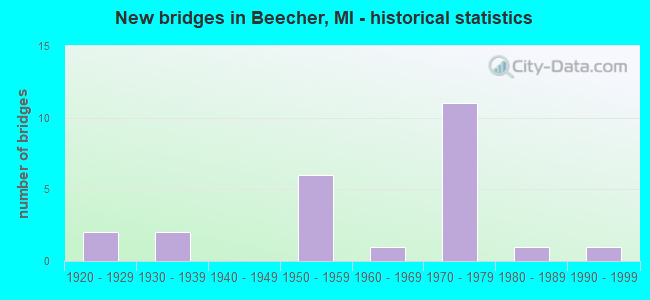
- New bridges - historical statistics
- 21920-1929
- 21930-1939
- 61950-1959
- 11960-1969
- 111970-1979
- 11980-1989
- 11990-1999
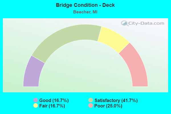
- Bridge Condition - Deck
- 16.7%Good
- 41.7%Satisfactory
- 16.7%Fair
- 25.0%Poor
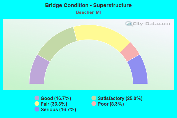
- Bridge Condition - Superstructure
- 16.7%Good
- 25.0%Satisfactory
- 33.3%Fair
- 8.3%Poor
- 16.7%Serious
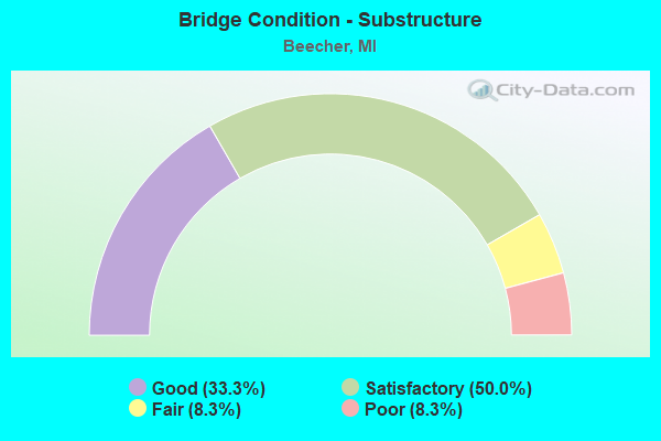
- Bridge Condition - Substructure
- 33.3%Good
- 50.0%Satisfactory
- 8.3%Fair
- 8.3%Poor
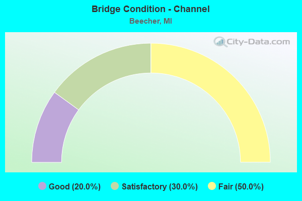
- Bridge Condition - Channel
- 20.0%Good
- 30.0%Satisfactory
- 50.0%Fair
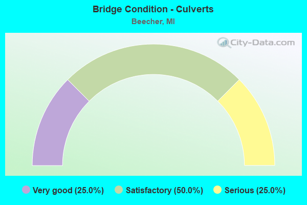
- Bridge Condition - Culverts
- 25.0%Very good
- 50.0%Satisfactory
- 25.0%Serious
Find on map >> Show street view
Structure Number: 4, Location: W LTS OF TRENARY (Lat: 46.195006, Lng: -86.972272), Route carried "on" structure: State highway 67, Year Built: 1953, Status: Open, Structure Length: 1.37m (4.49ft), Average Daily Traffic: 1,352 (year 2007), Truck Traffic: 9%, Average Future Daily Traffic: 1,509 (year 2018), Design Load: H 20, Features Intersected: SCOTTS CREEK
Minimum Vertical Clearance: 30.48m (100.00ft), Kilometerpoint: 1.471, Lanes on structure: 2, Base Highway Network: Yes (Inventory Route: 113, Subroute: 8), Owner: State Highway Agency, Approaching Roadway Width: 12.2m (40.0ft), Material/Design: Concrete, Design/Construction: Arch - Deck, Number Of Spans In Main Unit: 1, Length of Maximum Span: 13.7m (44.9ft), Curb or Sidewalk Widths: Left: 0.4m (1.3ft), Right: 0.4m (1.3ft), Curb-To-Curb Width: 11.6m (38.1ft), Out-to-Out Width: 13.2m (43.3ft)
Condition: Deck: Fair, Superstructure: Fair, Substructure: Satisfactory, Channel: Good, Operating Rating: 66.9 metric tons, Method Used To Determine Operating Rating: Load Factor (LF), Inventory Rating: 40.5 metric tons, Method Used To Determine Inventory Rating: Load Factor (LF), Structural Evaluation: Somewhat better than minimum adequacy, Deck Geometry: Equal to present minimum criteria, Waterway Adequacy: Equal to present desirable criteria, Approach Roadway Alignment: Better than present minimum criteria, Designated Inspection Frequency: Every 24 months, Inspection Date: May 2021, Deck Structure Type: Concrete Cast-file-Place, Wearing Surface/Protective System: Wearing Surface: Bituminous
Find on map >> Show street view
Structure Number: 399, Location: 2.4 MI S OF IOSCO CO LINE (Lat: 44.129028, Lng: -83.570194), Route carried "on" structure: US 23, Year Built: 1999, Status: Open, Structure Length: 0.61m (2.00ft), Average Daily Traffic: 5,497 (year 2007), Truck Traffic: 5%, Average Future Daily Traffic: 7,354 (year 2018), Design Load: HS 25 or greater, Features Intersected: DIME DRAIN
Minimum Vertical Clearance: 30.48m (100.00ft), Kilometerpoint: 40.571, Lanes on structure: 2, Base Highway Network: Yes (Inventory Route: 106, Subroute: 3), Owner: State Highway Agency, Approaching Roadway Width: 10.9m (35.8ft), Material/Design: Concrete, Design/Construction: Culvert, Number Of Spans In Main Unit: 1, Length of Maximum Span: 6.1m (20.0ft), Curb-To-Curb Width: 15.8m (51.8ft), Out-to-Out Width: 17.2m (56.4ft)
Condition: Channel: Fair, Culverts: Very good, Operating Rating: 76.1 metric tons, Method Used To Determine Operating Rating: Load Factor (LF) rating reported by rating factor (RF) method using MS18 loading, Inventory Rating: 45.7 metric tons, Method Used To Determine Inventory Rating: Load Factor (LF) rating reported by rating factor (RF) method using MS18 loading, Structural Evaluation: Equal to present desirable criteria, Deck Geometry: Superior to present desirable criteria, Waterway Adequacy: Equal to present desirable criteria, Approach Roadway Alignment: Somewhat better than minimum adequacy, Designated Inspection Frequency: Every 24 months, Inspection Date: June 2020, Deck Structure Type: Concrete Cast-file-Place, Wearing Surface/Protective System: Wearing Surface: Monolithic Concrete
Find on map >> Show street view
Structure Number: 1632, Location: 5 MI SW OF SAULT ST MARI (Lat: 46.418867, Lng: -84.467503), Route carried "on" structure: County highway 1758, Year Built: 1961, Status: Posted for load, Structure Length: 0.94m (3.08ft), Average Daily Traffic: 1,000 (year 1986), Average Future Daily Traffic: 1,745 (year 2019), Features Intersected: WALSKA RIVER, Facility Carried by Structure: 6 MI ROAD
Minimum Vertical Clearance: 30.48m (100.00ft), Kilometerpoint: 43.274, Lanes on structure: 2, Owner: County Highway Agency, Approaching Roadway Width: 10.1m (33.1ft), Material/Design: Steel, Design/Construction: Culvert, Number Of Spans In Main Unit: 2, Length of Maximum Span: 4.2m (13.8ft), Curb-To-Curb Width: 10.1m (33.1ft), Out-to-Out Width: 18.3m (60.0ft)
Condition: Channel: Satisfactory, Culverts: Serious, Operating Rating: 4.9 metric tons, Method Used To Determine Operating Rating: Load Factor (LF) rating reported by rating factor (RF) method using MS18 loading, Inventory Rating: 2.9 metric tons, Method Used To Determine Inventory Rating: Load Factor (LF) rating reported by rating factor (RF) method using MS18 loading, Structural Evaluation: High priority of corrective action, Deck Geometry: Equal to present minimum criteria, Waterway Adequacy: Equal to present desirable criteria, Approach Roadway Alignment: Equal to present desirable criteria, Bridge Posting: Required (Relationship of Operating Rating to Maximum Legal Load: > 39.9% below), Designated Inspection Frequency: Every 12 months, Inspection Date: June 2021
Find on map >> Show street view
Structure Number: 1634, Location: 3 MI S OF RUDYARD (Lat: 46.190586, Lng: -84.611750), Route carried "on" structure: County highway 1726, Year Built: 1986, Status: Open, Structure Length: 3.65m (11.98ft), Average Daily Traffic: 14 (year 1986), Average Future Daily Traffic: 25 (year 2019), Design Load: HS 20, Features Intersected: PINE RIVER, Facility Carried by Structure: PRARIE ROAD
Minimum Vertical Clearance: 30.48m (100.00ft), Kilometerpoint: 3.591, Lanes on structure: 2, Owner: County Highway Agency, Approaching Roadway Width: 9.1m (29.9ft), Material/Design: Steel continuous, Design/Construction: Stringer/Multi-beam, Number Of Spans In Main Unit: 3, Length of Maximum Span: 15.2m (49.9ft), Curb-To-Curb Width: 9.1m (29.9ft), Out-to-Out Width: 10.0m (32.8ft)
Condition: Deck: Good, Superstructure: Good, Substructure: Good, Channel: Satisfactory, Operating Rating: 64.2 metric tons, Method Used To Determine Operating Rating: Load Factor (LF) rating reported by rating factor (RF) method using MS18 loading, Inventory Rating: 38.6 metric tons, Method Used To Determine Inventory Rating: Load Factor (LF) rating reported by rating factor (RF) method using MS18 loading, Structural Evaluation: Better than present minimum criteria, Deck Geometry: Better than present minimum criteria, Waterway Adequacy: Equal to present desirable criteria, Approach Roadway Alignment: Equal to present minimum criteria, Designated Inspection Frequency: Every 24 months, Inspection Date: June 2021, Deck Structure Type: Concrete Cast-file-Place, Wearing Surface/Protective System: Wearing Surface: Monolithic Concrete, Deck Protection: Epoxy Coated Reinforcing
Find on map >> Show street view
Structure Number: 2507, Location: 6.1 MI S OF M-57 (Lat: 43.089744, Lng: -83.762856), Route carried "on" structure: County highway 2002, Year Built: 1957, Status: Open, Structure Length: 6.18m (20.28ft), Average Daily Traffic: 3,308 (year 1996), Truck Traffic: 3%, Average Future Daily Traffic: 6,000 (year 2016), Design Load: H 20, Features Intersected: I-75, Facility Carried by Structure: COLDWATER RD
Minimum Vertical Clearance: 30.48m (100.00ft), Kilometerpoint: 7.345, Lanes on structure: 4, Lanes under structure: 6, Owner: State Highway Agency, Approaching Roadway Width: 14.6m (47.9ft), Material/Design: Steel, Design/Construction: Stringer/Multi-beam, Number Of Spans In Main Unit: 4, Length of Maximum Span: 21.3m (69.9ft), Curb-To-Curb Width: 14.6m (47.9ft), Out-to-Out Width: 16.9m (55.4ft)
Condition: Deck: Poor, Superstructure: Serious, Substructure: Satisfactory, Operating Rating: 76.8 metric tons, Method Used To Determine Operating Rating: Load Factor (LF) rating reported by rating factor (RF) method using MS18 loading, Inventory Rating: 46.0 metric tons, Method Used To Determine Inventory Rating: Load Factor (LF) rating reported by rating factor (RF) method using MS18 loading, Structural Evaluation: High priority of corrective action, Deck Geometry: High priority of replacement, Underclear: High priority of corrective action, Approach Roadway Alignment: Equal to present desirable criteria, Designated Inspection Frequency: Every 12 months, Inspection Date: September 2021, Deck Structure Type: Concrete Cast-file-Place, Wearing Surface/Protective System: Wearing Surface: Epoxy Overlay
Find on map >> Show street view
Structure Number: 2508, Location: 5.1 MI S OF M-57 (Lat: 43.104375, Lng: -83.763125), Route carried "on" structure: County highway , Year Built: 1972, Status: Open, Structure Length: 8.69m (28.51ft), Average Daily Traffic: 2,000 (year 1996), Truck Traffic: 3%, Average Future Daily Traffic: 3,600 (year 2016), Design Load: H 20, Features Intersected: I-75, Facility Carried by Structure: STANLEY RD
Minimum Vertical Clearance: 30.48m (100.00ft), Kilometerpoint: 7.326, Lanes on structure: 2, Lanes under structure: 7, Owner: State Highway Agency, Approaching Roadway Width: 13.4m (44.0ft), Material/Design: Steel, Design/Construction: Stringer/Multi-beam, Number Of Spans In Main Unit: 3, Length of Maximum Span: 41.1m (134.8ft), Curb-To-Curb Width: 13.6m (44.6ft), Out-to-Out Width: 14.8m (48.6ft)
Condition: Deck: Satisfactory, Superstructure: Fair, Substructure: Good, Operating Rating: 65.1 metric tons, Method Used To Determine Operating Rating: Load Factor (LF) rating reported by rating factor (RF) method using MS18 loading, Inventory Rating: 38.9 metric tons, Method Used To Determine Inventory Rating: Load Factor (LF) rating reported by rating factor (RF) method using MS18 loading, Structural Evaluation: Somewhat better than minimum adequacy, Deck Geometry: Superior to present desirable criteria, Underclear: Somewhat better than minimum adequacy, Approach Roadway Alignment: Equal to present desirable criteria, Designated Inspection Frequency: Every 24 months, Inspection Date: June 2020, Deck Structure Type: Concrete Cast-file-Place, Wearing Surface/Protective System: Wearing Surface: Epoxy Overlay
Find on map >> Show street view
Structure Number: 2509, Location: 4.1 MI S OF M-57 (Lat: 43.118967, Lng: -83.763267), Route carried "on" structure: County highway 2574, Year Built: 1957, Year Reconstructed: 1987, Status: Open, Structure Length: 6.16m (20.21ft), Average Daily Traffic: 9,877 (year 1996), Truck Traffic: 5%, Average Future Daily Traffic: 17,800 (year 2016), Design Load: H 20, Features Intersected: I-75, Facility Carried by Structure: MT MORRIS RD
Minimum Vertical Clearance: 30.48m (100.00ft), Kilometerpoint: 13.479, Lanes on structure: 2, Lanes under structure: 6, Owner: State Highway Agency, Approaching Roadway Width: 9.8m (32.2ft), Material/Design: Steel, Design/Construction: Stringer/Multi-beam, Number Of Spans In Main Unit: 4, Length of Maximum Span: 21.3m (69.9ft), Curb-To-Curb Width: 9.7m (31.8ft), Out-to-Out Width: 10.7m (35.1ft)
Condition: Deck: Satisfactory, Superstructure: Satisfactory, Substructure: Satisfactory, Operating Rating: 57.3 metric tons, Method Used To Determine Operating Rating: Load Factor (LF) rating reported by rating factor (RF) method using MS18 loading, Inventory Rating: 34.3 metric tons, Method Used To Determine Inventory Rating: Load Factor (LF) rating reported by rating factor (RF) method using MS18 loading, Structural Evaluation: Equal to present minimum criteria, Deck Geometry: Meets minimum limits, Underclear: Meets minimum limits, Approach Roadway Alignment: Equal to present desirable criteria, Designated Inspection Frequency: Every 24 months, Inspection Date: June 2020, Deck Structure Type: Concrete Cast-file-Place, Wearing Surface/Protective System: Wearing Surface: Epoxy Overlay, Deck Protection: Epoxy Coated Reinforcing
Find on map >> Show street view
Structure Number: 2639, Location: 0.2 MI E OF CLIO RD (Lat: 43.098011, Lng: -83.726747), Route carried "on" structure: Interstate 475, Year Built: 1973, Status: Open, Structure Length: 0.68m (2.23ft), Average Daily Traffic: 26,600 (year 2007), Truck Traffic: 8%, Average Future Daily Traffic: 28,209 (year 2018), Design Load: HS 20+Mod, Features Intersected: LAKE DRAIN
Minimum Vertical Clearance: 30.48m (100.00ft), Kilometerpoint: 23.789, Lanes on structure: 4, Base Highway Network: Yes (Inventory Route: 149, Subroute: 3), Owner: State Highway Agency, Approaching Roadway Width: 23.2m (76.1ft), Material/Design: Concrete, Design/Construction: Culvert, Number Of Spans In Main Unit: 2, Length of Maximum Span: 3.0m (9.8ft), Curb-To-Curb Width: 65.4m (214.6ft), Out-to-Out Width: 65.8m (215.9ft)
Condition: Channel: Fair, Culverts: Satisfactory, Operating Rating: 59.0 metric tons, Method Used To Determine Operating Rating: Load Factor (LF) rating reported by rating factor (RF) method using MS18 loading, Inventory Rating: 35.3 metric tons, Method Used To Determine Inventory Rating: Load Factor (LF) rating reported by rating factor (RF) method using MS18 loading, Structural Evaluation: Equal to present minimum criteria, Deck Geometry: Superior to present desirable criteria, Waterway Adequacy: Equal to present minimum criteria, Approach Roadway Alignment: Equal to present minimum criteria, Designated Inspection Frequency: Every 24 months, Inspection Date: July 2020
Find on map >> Show street view
Structure Number: 2679, Location: NORTH OF CITY OF FLINT (Lat: 43.081539, Lng: -83.684956), Route carried "on" structure: County highway , Year Built: 1977, Status: Open, Structure Length: 7.76m (25.46ft), Average Daily Traffic: 2,723 (year 1996), Truck Traffic: 4%, Average Future Daily Traffic: 4,900 (year 2016), Design Load: HS 20, Features Intersected: I-475, Facility Carried by Structure: SELBY STREET
Minimum Vertical Clearance: 30.48m (100.00ft), Kilometerpoint: 3.079, Lanes on structure: 2, Lanes under structure: 6, Owner: State Highway Agency, Approaching Roadway Width: 12.2m (40.0ft), Skew: 5 degrees, Material/Design: Steel, Design/Construction: Stringer/Multi-beam, Number Of Spans In Main Unit: 2, Length of Maximum Span: 40.5m (132.9ft), Curb or Sidewalk Widths: Left: 1.8m (5.9ft), Right: 1.8m (5.9ft), Curb-To-Curb Width: 8.5m (27.9ft), Out-to-Out Width: 12.9m (42.3ft)
Condition: Deck: Satisfactory, Superstructure: Good, Substructure: Good, Operating Rating: 61.9 metric tons, Method Used To Determine Operating Rating: Load Factor (LF) rating reported by rating factor (RF) method using MS18 loading, Inventory Rating: 37.3 metric tons, Method Used To Determine Inventory Rating: Load Factor (LF) rating reported by rating factor (RF) method using MS18 loading, Structural Evaluation: Better than present minimum criteria, Deck Geometry: Meets minimum limits, Underclear: High priority of corrective action, Approach Roadway Alignment: Equal to present desirable criteria, Length Of Structure Improvement: 7.65m (25.10ft), Designated Inspection Frequency: Every 24 months, Inspection Date: July 2020, Bridge Improvement Cost: $168,000, Roadway Improvement Cost: $10,000, Total Project Cost: $113,000, Deck Structure Type: Concrete Cast-file-Place, Wearing Surface/Protective System: Wearing Surface: Latex Concrete
Find on map >> Show street view
Structure Number: 2697, Location: NORTH OF FLINT (Lat: 43.083514, Lng: -83.685800), Route carried "on" structure: County highway 2002, Year Built: 1977, Status: Open, Structure Length: 4.54m (14.90ft), Average Daily Traffic: 500 (year 1996), Truck Traffic: 3%, Average Future Daily Traffic: 900 (year 2016), Design Load: HS 25 or greater, Features Intersected: I-475, Facility Carried by Structure: CORNELL AVE
Minimum Vertical Clearance: 30.48m (100.00ft), Kilometerpoint: 2.218, Lanes on structure: 2, Lanes under structure: 6, Owner: State Highway Agency, Approaching Roadway Width: 12.8m (42.0ft), Skew: 1 degrees, Material/Design: Steel, Design/Construction: Stringer/Multi-beam, Number Of Spans In Main Unit: 2, Length of Maximum Span: 22.8m (74.8ft), Curb or Sidewalk Widths: Left: 1.8m (5.9ft), Right: 1.8m (5.9ft), Curb-To-Curb Width: 9.1m (29.9ft), Out-to-Out Width: 13.5m (44.3ft)
Condition: Deck: Good, Superstructure: Fair, Substructure: Satisfactory, Operating Rating: 65.1 metric tons, Method Used To Determine Operating Rating: Load Factor (LF), Inventory Rating: 39.0 metric tons, Method Used To Determine Inventory Rating: Load Factor (LF), Structural Evaluation: Somewhat better than minimum adequacy, Deck Geometry: Equal to present minimum criteria, Underclear: Meets minimum limits, Approach Roadway Alignment: Equal to present desirable criteria, Designated Inspection Frequency: Every 24 months, Inspection Date: April 2021, Bridge Improvement Cost: $512,000, Roadway Improvement Cost: $46,000, Total Project Cost: $538,000, Deck Structure Type: Concrete Cast-file-Place, Wearing Surface/Protective System: Wearing Surface: Latex Concrete
Find on map >> Show street view
Structure Number: 2726, Location: BETWEEN SAGINAW & DORT HW (Lat: 43.090450, Lng: -83.676828), Route carried "on" structure: County highway 2002, Year Built: 1972, Status: Open, Structure Length: 7.74m (25.39ft), Average Daily Traffic: 3,338 (year 2018), Truck Traffic: 5%, Average Future Daily Traffic: 6,029 (year 2038), Design Load: HS 20+Mod, Features Intersected: C & O RAILROAD, Facility Carried by Structure: COLDWATER ROAD
Minimum Vertical Clearance: 30.48m (100.00ft), Kilometerpoint: 14.366, Lanes on structure: 4, Owner: County Highway Agency, Approaching Roadway Width: 15.9m (52.2ft), Skew: 1 degrees, Material/Design: Steel, Design/Construction: Stringer/Multi-beam, Number Of Spans In Main Unit: 4, Length of Maximum Span: 25.9m (85.0ft), Curb or Sidewalk Widths: Left: 1.5m (4.9ft), Right: 1.5m (4.9ft), Curb-To-Curb Width: 15.9m (52.2ft), Out-to-Out Width: 19.6m (64.3ft)
Condition: Deck: Satisfactory, Superstructure: Satisfactory, Substructure: Good, Operating Rating: 73.2 metric tons, Method Used To Determine Operating Rating: Load Factor (LF) rating reported by rating factor (RF) method using MS18 loading, Inventory Rating: 43.7 metric tons, Method Used To Determine Inventory Rating: Load Factor (LF) rating reported by rating factor (RF) method using MS18 loading, Structural Evaluation: Equal to present minimum criteria, Deck Geometry: Meets minimum limits, Underclear: High priority of corrective action, Approach Roadway Alignment: Equal to present desirable criteria, Designated Inspection Frequency: Every 24 months, Inspection Date: November 2020, Deck Structure Type: Concrete Cast-file-Place, Wearing Surface/Protective System: Wearing Surface: Monolithic Concrete
Find on map >> Show street view
Structure Number: 273, Location: BET JENNINGS & CLIO RD (Lat: 43.119225, Lng: -83.751533), Route carried "on" structure: County highway 2574, Year Built: 1929, Status: Open, Structure Length: 0.82m (2.69ft), Average Daily Traffic: 6,864 (year 2017), Truck Traffic: 5%, Average Future Daily Traffic: 12,397 (year 2037), Design Load: HS 20+Mod, Features Intersected: BRENT RUN, Facility Carried by Structure: MT MORRIS ROAD
Minimum Vertical Clearance: 30.48m (100.00ft), Kilometerpoint: 14.435, Lanes on structure: 2, Owner: County Highway Agency, Approaching Roadway Width: 11.9m (39.0ft), Material/Design: Concrete, Design/Construction: Tee Beam, Number Of Spans In Main Unit: 1, Length of Maximum Span: 7.3m (24.0ft), Curb-To-Curb Width: 11.0m (36.1ft), Out-to-Out Width: 11.6m (38.1ft)
Condition: Deck: Poor, Superstructure: Poor, Substructure: Fair, Channel: Fair, Operating Rating: 42.4 metric tons, Method Used To Determine Operating Rating: Load Factor (LF) rating reported by rating factor (RF) method using MS18 loading, Inventory Rating: 25.3 metric tons, Method Used To Determine Inventory Rating: Load Factor (LF) rating reported by rating factor (RF) method using MS18 loading, Structural Evaluation: Meets minimum limits, Deck Geometry: Meets minimum limits, Waterway Adequacy: Equal to present desirable criteria, Approach Roadway Alignment: Equal to present desirable criteria, Length Of Structure Improvement: 0.91m (2.99ft), Designated Inspection Frequency: Every 12 months, Inspection Date: November 2021, Bridge Improvement Cost: $128,000, Roadway Improvement Cost: $13,000, Total Project Cost: $157,000, Deck Structure Type: Concrete Cast-file-Place, Wearing Surface/Protective System: Wearing Surface: Bituminous
Find on map >> Show street view
Structure Number: 2801, Location: BET JENNINGS & CLIO ROAD (Lat: 43.134042, Lng: -83.744869), Route carried "on" structure: County highway , Year Built: 1925, Status: Posted for load, Structure Length: 0.82m (2.69ft), Average Daily Traffic: 364 (year 2009), Truck Traffic: 2%, Average Future Daily Traffic: 657 (year 2029), Design Load: HS 20+Mod, Features Intersected: BRENT RUN, Facility Carried by Structure: FRANCES ROAD
Minimum Vertical Clearance: 30.48m (100.00ft), Kilometerpoint: 1.473, Lanes on structure: 2, Owner: County Highway Agency, Approaching Roadway Width: 9.1m (29.9ft), Material/Design: Concrete, Design/Construction: Tee Beam, Number Of Spans In Main Unit: 1, Length of Maximum Span: 7.9m (25.9ft), Curb-To-Curb Width: 7.0m (23.0ft), Out-to-Out Width: 7.9m (25.9ft)
Condition: Deck: Satisfactory, Superstructure: Satisfactory, Substructure: Satisfactory, Channel: Fair, Operating Rating: 47.0 metric tons, Method Used To Determine Operating Rating: Load Factor (LF) rating reported by rating factor (RF) method using MS18 loading, Inventory Rating: 28.2 metric tons, Method Used To Determine Inventory Rating: Load Factor (LF) rating reported by rating factor (RF) method using MS18 loading, Structural Evaluation: Equal to present minimum criteria, Deck Geometry: Meets minimum limits, Waterway Adequacy: Meets minimum limits, Approach Roadway Alignment: Equal to present minimum criteria, Bridge Posting: Required (Relationship of Operating Rating to Maximum Legal Load: 0.1 - 9.9% below), Designated Inspection Frequency: Every 24 months, Inspection Date: November 2020, Deck Structure Type: Concrete Cast-file-Place, Wearing Surface/Protective System: Wearing Surface: Monolithic Concrete
Find on map >> Show street view
Structure Number: 401, Location: 0.3 MI W OF MUIR (Lat: 43.001511, Lng: -84.950447), Route carried "on" structure: State highway 21, Year Built: 1932, Status: Open, Structure Length: 0.73m (2.40ft), Average Daily Traffic: 5,580 (year 2007), Truck Traffic: 7%, Average Future Daily Traffic: 6,741 (year 2018), Design Load: H 15, Features Intersected: SPIRES CREEK
Minimum Vertical Clearance: 30.48m (100.00ft), Kilometerpoint: 20.064, Lanes on structure: 2, Base Highway Network: Yes (Inventory Route: 50, Subroute: 6), Owner: State Highway Agency, Approaching Roadway Width: 12.2m (40.0ft), Material/Design: Concrete continuous, Design/Construction: Culvert, Number Of Spans In Main Unit: 2, Length of Maximum Span: 3.6m (11.8ft), Curb-To-Curb Width: 11.0m (36.1ft), Out-to-Out Width: 23.4m (76.8ft)
Condition: Channel: Good, Culverts: Satisfactory, Operating Rating: 97.2 metric tons, Method Used To Determine Operating Rating: Load Factor (LF) rating reported by rating factor (RF) method using MS18 loading, Inventory Rating: 79.7 metric tons, Method Used To Determine Inventory Rating: Load Factor (LF) rating reported by rating factor (RF) method using MS18 loading, Structural Evaluation: Equal to present minimum criteria, Deck Geometry: Meets minimum limits, Waterway Adequacy: Equal to present desirable criteria, Approach Roadway Alignment: Equal to present minimum criteria, Designated Inspection Frequency: Every 24 months, Inspection Date: December 2020, Deck Structure Type: Concrete Cast-file-Place
Find on map >> Show street view
Structure Number: 402, Location: 5 MI S OF IONIA & 1 MI E (Lat: 42.885989, Lng: -85.055217), Route carried "on" structure: ServiceCounty highway , Year Built: 1936, Status: Open, Structure Length: 0.70m (2.30ft), Average Daily Traffic: 1,093 (year 2010), Truck Traffic: 8%, Average Future Daily Traffic: 1,521 (year 2027), Design Load: HS 20+Mod, Features Intersected: LIBHART CREEK, Facility Carried by Structure: GRAND RIVER AVENUE
Minimum Vertical Clearance: 30.48m (100.00ft), Kilometerpoint: 20.983, Lanes on structure: 2, Owner: County Highway Agency, Approaching Roadway Width: 10.1m (33.1ft), Material/Design: Concrete, Design/Construction: Tee Beam, Number Of Spans In Main Unit: 1, Length of Maximum Span: 6.1m (20.0ft), Curb-To-Curb Width: 11.0m (36.1ft), Out-to-Out Width: 11.6m (38.1ft)
Condition: Deck: Poor, Superstructure: Serious, Substructure: Poor, Channel: Fair, Operating Rating: 40.2 metric tons, Method Used To Determine Operating Rating: Load Factor (LF) rating reported by rating factor (RF) method using MS18 loading, Inventory Rating: 24.0 metric tons, Method Used To Determine Inventory Rating: Load Factor (LF) rating reported by rating factor (RF) method using MS18 loading, Structural Evaluation: High priority of corrective action, Deck Geometry: Equal to present minimum criteria, Waterway Adequacy: Equal to present minimum criteria, Approach Roadway Alignment: Equal to present desirable criteria, Designated Inspection Frequency: Every 12 months, Inspection Date: October 2021, Deck Structure Type: Concrete Cast-file-Place, Wearing Surface/Protective System: Wearing Surface: Bituminous
Find on map >> Show street view
Structure Number: 5517, Location: 0.5 MI S OF ADRIAN (Lat: 41.879350, Lng: -84.052597), Route carried "on" structure: US 223, Year Built: 1953, Status: Open, Structure Length: 4.57m (14.99ft), Average Daily Traffic: 13,253 (year 2007), Truck Traffic: 10%, Average Future Daily Traffic: 19,561 (year 2018), Design Load: HS 20, Features Intersected: S BR RAISIN RIVER
Minimum Vertical Clearance: 30.48m (100.00ft), Kilometerpoint: 32.434, Lanes on structure: 2, Base Highway Network: Yes (Inventory Route: 94, Subroute: 2), Owner: State Highway Agency, Approaching Roadway Width: 12.8m (42.0ft), Skew: 1 degrees, Material/Design: Concrete continuous, Design/Construction: Tee Beam, Number Of Spans In Main Unit: 3, Length of Maximum Span: 18.2m (59.7ft), Curb-To-Curb Width: 13.1m (43.0ft), Out-to-Out Width: 14.3m (46.9ft)
Condition: Deck: Fair, Superstructure: Fair, Substructure: Satisfactory, Channel: Satisfactory, Operating Rating: 57.0 metric tons, Method Used To Determine Operating Rating: Load Factor (LF) rating reported by rating factor (RF) method using MS18 loading, Inventory Rating: 34.0 metric tons, Method Used To Determine Inventory Rating: Load Factor (LF) rating reported by rating factor (RF) method using MS18 loading, Structural Evaluation: Somewhat better than minimum adequacy, Deck Geometry: Somewhat better than minimum adequacy, Waterway Adequacy: Equal to present desirable criteria, Approach Roadway Alignment: Equal to present desirable criteria, Designated Inspection Frequency: Every 24 months, Inspection Date: July 2020, Deck Structure Type: Concrete Cast-file-Place, Wearing Surface/Protective System: Wearing Surface: Epoxy Overlay
Find on map >> Show street view
Structure Number: 2507, Location: 6.1 MI S OF M-57 (Lat: 43.089744, Lng: -83.762856), Route carried "under" structure: Interstate 75, Year Built: 1957, Structure Length: 0. m, Average Daily Traffic: 64,650 (year 2007), Truck Traffic: 8%, Features Intersected: I-75, Facility Carried by Structure: COLDWATER RD
Minimum Vertical Clearance: 4.44m (14.57ft), Kilometerpoint: 30.186, Lanes on structure: 4, Lanes under structure: 6, Material/Design: Steel, Design/Construction: Stringer/Multi-beam, Length of Maximum Span: 21.3m (69.9ft)
Find on map >> Show street view
Structure Number: 2508, Location: 5.1 MI S OF M-57 (Lat: 43.104375, Lng: -83.763125), Route carried "under" structure: Interstate 75, Year Built: 1972, Structure Length: 0. m, Average Daily Traffic: 77,442 (year 2007), Truck Traffic: 10%, Features Intersected: I-75, Facility Carried by Structure: STANLEY RD
Minimum Vertical Clearance: 5.00m (16.40ft), Kilometerpoint: 31.811, Lanes on structure: 2, Lanes under structure: 7, Material/Design: Steel, Design/Construction: Stringer/Multi-beam, Length of Maximum Span: 41.1m (134.8ft)
Find on map >> Show street view
Structure Number: 2509, Location: 4.1 MI S OF M-57 (Lat: 43.118967, Lng: -83.763267), Route carried "under" structure: Interstate 75, Year Built: 1957, Structure Length: 0. m, Average Daily Traffic: 77,442 (year 2007), Truck Traffic: 12%, Features Intersected: I-75, Facility Carried by Structure: MT MORRIS RD
Minimum Vertical Clearance: 5.03m (16.50ft), Kilometerpoint: 33.432, Lanes on structure: 2, Lanes under structure: 6, Material/Design: Steel, Design/Construction: Stringer/Multi-beam, Length of Maximum Span: 21.3m (69.9ft)
Find on map >> Show street view
Structure Number: 2679, Location: NORTH OF CITY OF FLINT (Lat: 43.081539, Lng: -83.684956), Route carried "under" structure: Interstate 475, Year Built: 1977, Structure Length: 0. m, Average Daily Traffic: 31,300 (year 2007), Truck Traffic: 7%, Features Intersected: I-475, Facility Carried by Structure: SELBY STREET
Minimum Vertical Clearance: 4.70m (15.42ft), Kilometerpoint: 18.856, Lanes on structure: 2, Lanes under structure: 6, Material/Design: Steel, Design/Construction: Stringer/Multi-beam, Length of Maximum Span: 40.5m (132.9ft)
Find on map >> Show street view
Structure Number: 2683, Location: N JCT I-75 (Lat: 43.097756, Lng: -83.763011), Route carried "under" structure: Interstate 75, Year Built: 1971, Structure Length: 0. m, Average Daily Traffic: 77,442 (year 2007), Truck Traffic: 10%, Features Intersected: I-475RAMP B & I-75
Minimum Vertical Clearance: 4.62m (15.16ft), Kilometerpoint: 31.076, Lanes on structure: 2, Lanes under structure: 4, Material/Design: Steel, Design/Construction: Stringer/Multi-beam, Length of Maximum Span: 32.6m (107.0ft)
Find on map >> Show street view
Structure Number: 2684, Location: 1.2 M N OF FLINT CITY LTS (Lat: 43.093892, Lng: -83.686908), Route carried "under" structure: Interstate 475, Year Built: 1977, Structure Length: 0. m, Average Daily Traffic: 31,300 (year 2007), Truck Traffic: 7%, Features Intersected: I-475, Facility Carried by Structure: TERRY STREET
Minimum Vertical Clearance: 4.67m (15.32ft), Kilometerpoint: 20.246, Lanes on structure: 2, Lanes under structure: 6, Material/Design: Steel, Design/Construction: Stringer/Multi-beam, Length of Maximum Span: 23.1m (75.8ft)
Find on map >> Show street view
Structure Number: 2692, Location: N JCT I-75 (Lat: 43.097392, Lng: -83.762994), Route carried "under" structure: Interstate 75, Year Built: 1971, Structure Length: 0. m, Average Daily Traffic: 77,442 (year 2007), Truck Traffic: 10%, Features Intersected: I-75
Minimum Vertical Clearance: 5.59m (18.34ft), Kilometerpoint: 31.036, Lanes on structure: 2, Lanes under structure: 6, Material/Design: Steel, Design/Construction: Stringer/Multi-beam, Length of Maximum Span: 45.4m (149.0ft)
Find on map >> Show street view
Structure Number: 2697, Location: NORTH OF FLINT (Lat: 43.083514, Lng: -83.685800), Route carried "under" structure: Interstate 475, Year Built: 1977, Structure Length: 0. m, Average Daily Traffic: 31,300 (year 2007), Truck Traffic: 7%, Features Intersected: I-475, Facility Carried by Structure: CORNELL AVE
Minimum Vertical Clearance: 4.80m (15.75ft), Kilometerpoint: 19.086, Lanes on structure: 2, Lanes under structure: 6, Material/Design: Steel, Design/Construction: Stringer/Multi-beam, Length of Maximum Span: 22.8m (74.8ft)