Bridge Statistics for Bellview, Florida (FL)
Condition, Traffic, Stress, Structural Evaluation, Project Costs
- National Bridge Inventory (NBI) Statistics
- 11Number of bridges
- 144ft / 44.4mTotal length
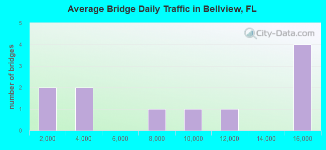
- 93,450Total average daily traffic
- 5,582Total average daily truck traffic
- 162,138Total future (year 2041) average daily traffic
- National Bridge Inventory (NBI) Registered Bridges for Bellview
- No street view available for this location
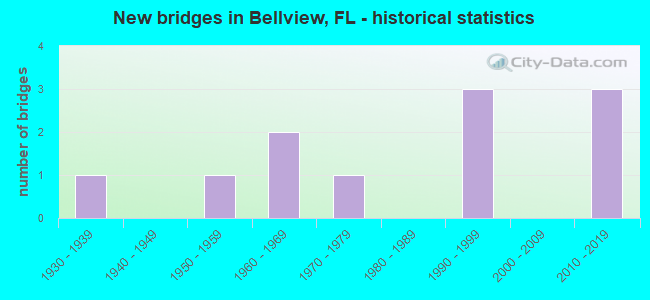
- New bridges - historical statistics
- 11930-1939
- 11950-1959
- 21960-1969
- 11970-1979
- 31990-1999
- 32010-2019
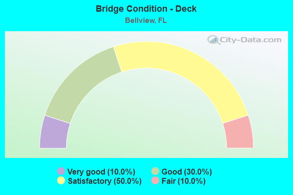
- Bridge Condition - Deck
- 10.0%Very good
- 30.0%Good
- 50.0%Satisfactory
- 10.0%Fair
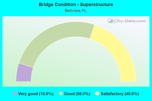
- Bridge Condition - Superstructure
- 10.0%Very good
- 50.0%Good
- 40.0%Satisfactory
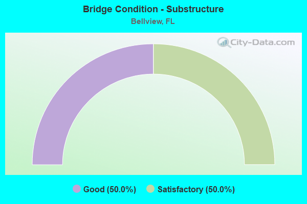
- Bridge Condition - Substructure
- 50.0%Good
- 50.0%Satisfactory
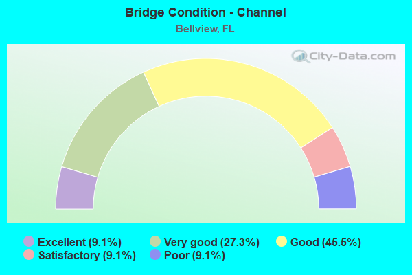
- Bridge Condition - Channel
- 9.1%Excellent
- 27.3%Very good
- 45.5%Good
- 9.1%Satisfactory
- 9.1%Poor
Find on map >> Show street view
Structure Number: 480003, Location: 1.5 mi West of SR297 (Lat: 30.493533, Lng: -87.325011), Route carried "on" structure: US 90, Year Built: 1939, Year Reconstructed: 1965, Status: Open, Structure Length: 1.95m (6.40ft), Average Daily Traffic: 14,100 (year 2020), Truck Traffic: 6%, Average Future Daily Traffic: 24,464 (year 2042), Design Load: HS 15, Features Intersected: Eight Mile Creek
Minimum Vertical Clearance: 30+ m (98+ ft), Kilometerpoint: 9.650, Lanes on structure: 2, Base Highway Network: Yes, Owner: State Highway Agency, Approaching Roadway Width: 10.4m (34.1ft), Material/Design: Concrete, Design/Construction: Slab, Number Of Spans In Main Unit: 4, Length of Maximum Span: 4.9m (16.1ft), Curb-To-Curb Width: 12.8m (42.0ft), Out-to-Out Width: 14.1m (46.3ft)
Condition: Deck: Satisfactory, Superstructure: Satisfactory, Substructure: Satisfactory, Channel: Good, Operating Rating: 36.8 metric tons, Method Used To Determine Operating Rating: Load and Resistance Factor (LRFR), Inventory Rating: 28.4 metric tons, Method Used To Determine Inventory Rating: Load and Resistance Factor (LRFR), Structural Evaluation: Equal to present minimum criteria, Deck Geometry: Somewhat better than minimum adequacy, Waterway Adequacy: High priority of corrective action, Approach Roadway Alignment: Equal to present desirable criteria, Designated Inspection Frequency: Every 24 months, Underwater Inspection Frequency: Every 24 months, Inspection Date: Febuary 2022, Underwater Inspection Date: Febuary 2022, Deck Structure Type: Concrete Cast-file-Place, Wearing Surface/Protective System: Wearing Surface: Bituminous
Find on map >> Show street view
Structure Number: 480022, Location: 2.0Mi West of SR727 (Lat: 30.420958, Lng: -87.350214), Route carried "on" structure: State highway 298, Year Built: 1972, Status: Open, Structure Length: 7.32m (24.02ft), Average Daily Traffic: 11,500 (year 2020), Truck Traffic: 6%, Average Future Daily Traffic: 19,952 (year 2042), Design Load: HS 20, Features Intersected: Mill View Bayou
Minimum Vertical Clearance: 30+ m (98+ ft), Kilometerpoint: 9.558, Lanes on structure: 2, Base Highway Network: Yes, Owner: State Highway Agency, Approaching Roadway Width: 8.5m (27.9ft), Material/Design: Concrete continuous, Design/Construction: Slab, Number Of Spans In Main Unit: 8, Length of Maximum Span: 9.1m (29.9ft), Curb-To-Curb Width: 13.1m (43.0ft), Out-to-Out Width: 14.1m (46.3ft)
Condition: Deck: Satisfactory, Superstructure: Satisfactory, Substructure: Satisfactory, Channel: Very good, Operating Rating: 52.6 metric tons, Method Used To Determine Operating Rating: Load Factor (LF), Inventory Rating: 30.8 metric tons, Method Used To Determine Inventory Rating: Load Factor (LF), Structural Evaluation: Equal to present minimum criteria, Deck Geometry: Somewhat better than minimum adequacy, Waterway Adequacy: Equal to present desirable criteria, Approach Roadway Alignment: Equal to present desirable criteria, Designated Inspection Frequency: Every 24 months, Underwater Inspection Frequency: Every 24 months, Inspection Date: April 2020, Underwater Inspection Date: April 2020, Deck Structure Type: Concrete Cast-file-Place
Find on map >> Show street view
Structure Number: 480133, Location: 1.0 Mi. East of SR296 (Lat: 30.448358, Lng: -87.290761), Route carried "on" structure: US 90, Year Built: 1961, Status: Open, Structure Length: 2.74m (8.99ft), Average Daily Traffic: 15,250 (year 2020), Truck Traffic: 5%, Average Future Daily Traffic: 26,459 (year 2042), Design Load: HS 20, Features Intersected: Marcus Creek
Minimum Vertical Clearance: 30+ m (98+ ft), Kilometerpoint: 15.746, Lanes on structure: 2, Base Highway Network: Yes, Owner: State Highway Agency, Approaching Roadway Width: 8.5m (27.9ft), Material/Design: Concrete, Design/Construction: Slab, Number Of Spans In Main Unit: 4, Length of Maximum Span: 6.9m (22.6ft), Curb-To-Curb Width: 11.6m (38.1ft), Out-to-Out Width: 13.2m (43.3ft)
Condition: Deck: Good, Superstructure: Good, Substructure: Satisfactory, Channel: Good, Operating Rating: 63.7 metric tons, Method Used To Determine Operating Rating: Load Factor (LF), Inventory Rating: 38.2 metric tons, Method Used To Determine Inventory Rating: Load Factor (LF), Structural Evaluation: Equal to present minimum criteria, Deck Geometry: Better than present minimum criteria, Waterway Adequacy: Equal to present desirable criteria, Approach Roadway Alignment: Equal to present desirable criteria, Designated Inspection Frequency: Every 24 months, Underwater Inspection Frequency: Every 24 months, Inspection Date: Febuary 2022, Underwater Inspection Date: Febuary 2022, Deck Structure Type: Concrete Cast-file-Place, Wearing Surface/Protective System: Wearing Surface: Bituminous
Find on map >> Show street view
Structure Number: 480182, Location: 1.0 Mi. East of SR296 (Lat: 30.448528, Lng: -87.290644), Route carried "on" structure: US 90, Year Built: 1995, Status: Open, Structure Length: 3.64m (11.94ft), Average Daily Traffic: 15,250 (year 2020), Truck Traffic: 5%, Average Future Daily Traffic: 26,459 (year 2042), Design Load: HS 20, Features Intersected: Marcus Creek
Minimum Vertical Clearance: 30+ m (98+ ft), Kilometerpoint: 15.743, Lanes on structure: 2, Base Highway Network: Yes, Owner: State Highway Agency, Approaching Roadway Width: 9.4m (30.8ft), Material/Design: Concrete continuous, Design/Construction: Slab, Number Of Spans In Main Unit: 4, Length of Maximum Span: 9.8m (32.2ft), Curb-To-Curb Width: 12.2m (40.0ft), Out-to-Out Width: 13.1m (43.0ft)
Condition: Deck: Satisfactory, Superstructure: Satisfactory, Substructure: Satisfactory, Channel: Very good, Operating Rating: 49.9 metric tons, Method Used To Determine Operating Rating: Load Factor (LF), Inventory Rating: 29.9 metric tons, Method Used To Determine Inventory Rating: Load Factor (LF), Structural Evaluation: Equal to present minimum criteria, Deck Geometry: Better than present minimum criteria, Waterway Adequacy: Superior to present desirable criteria, Approach Roadway Alignment: Equal to present desirable criteria, Designated Inspection Frequency: Every 24 months, Underwater Inspection Frequency: Every 24 months, Inspection Date: Febuary 2022, Underwater Inspection Date: Febuary 2022, Deck Structure Type: Concrete Cast-file-Place
Find on map >> Show street view
Structure Number: 48019, Location: 1.5Mi N of Saufley Field (Lat: 30.498247, Lng: -87.335983), Route carried "on" structure: US 90, Year Built: 1999, Status: Open, Structure Length: 9.45m (31.00ft), Average Daily Traffic: 14,100 (year 2020), Truck Traffic: 6%, Average Future Daily Traffic: 24,464 (year 2042), Design Load: HS 20, Features Intersected: Eleven Mile Creek
Minimum Vertical Clearance: 30+ m (98+ ft), Kilometerpoint: 8.428, Lanes on structure: 2, Base Highway Network: Yes, Owner: State Highway Agency, Approaching Roadway Width: 10.4m (34.1ft), Material/Design: Prestressed concrete, Design/Construction: Stringer/Multi-beam, Number Of Spans In Main Unit: 5, Length of Maximum Span: 18.9m (62.0ft), Curb-To-Curb Width: 13.2m (43.3ft), Out-to-Out Width: 14.1m (46.3ft)
Condition: Deck: Good, Superstructure: Good, Substructure: Good, Channel: Very good, Operating Rating: 67.2 metric tons, Method Used To Determine Operating Rating: Load Factor (LF), Inventory Rating: 40.4 metric tons, Method Used To Determine Inventory Rating: Load Factor (LF), Structural Evaluation: Better than present minimum criteria, Deck Geometry: Somewhat better than minimum adequacy, Waterway Adequacy: Equal to present desirable criteria, Approach Roadway Alignment: Equal to present desirable criteria, Designated Inspection Frequency: Every 24 months, Inspection Date: April 2020, Deck Structure Type: Concrete Cast-file-Place
Find on map >> Show street view
Structure Number: 484072, Location: 1.1 Mi East of Hwy 297 (Lat: 30.486272, Lng: -87.288319), Route carried "on" structure: County highway , Year Built: 1960, Status: Posted for load, Structure Length: 0.96m (3.15ft), Average Daily Traffic: 7,600 (year 2020), Truck Traffic: 9%, Average Future Daily Traffic: 13,186 (year 2042), Features Intersected: Bayou Marcus Creek, Facility Carried by Structure: Longleaf Drive
Minimum Vertical Clearance: 30+ m (98+ ft), Kilometerpoint: 0.135, Lanes on structure: 2, Owner: County Highway Agency, Approaching Roadway Width: 7.0m (23.0ft), Material/Design: Wood or Timber, Design/Construction: Stringer/Multi-beam, Number Of Spans In Main Unit: 2, Length of Maximum Span: 5.0m (16.4ft), Curb or Sidewalk Widths: Left: 0.2m (0.7ft), Right: 0.2m (0.7ft), Curb-To-Curb Width: 7.2m (23.6ft), Out-to-Out Width: 7.8m (25.6ft)
Condition: Deck: Fair, Superstructure: Satisfactory, Substructure: Satisfactory, Channel: Poor, Operating Rating: 17.9 metric tons, Method Used To Determine Operating Rating: Load and Resistance Factor (LRFR), Inventory Rating: 13.8 metric tons, Method Used To Determine Inventory Rating: Load and Resistance Factor (LRFR), Structural Evaluation: High priority of corrective action, Deck Geometry: High priority of replacement, Waterway Adequacy: Equal to present desirable criteria, Approach Roadway Alignment: Equal to present desirable criteria, Bridge Posting: Required (Relationship of Operating Rating to Maximum Legal Load: 30.0 - 39.9% below), Designated Inspection Frequency: Every 24 months, Underwater Inspection Frequency: Every 12 months, Other Special Inspection Frequency: Every 12 months, Inspection Date: September 2020, Underwater Inspection Date: September 2021, Other Special Inspection Date: September 2021, Deck Structure Type: Concrete Cast-file-Place
Find on map >> Show street view
Structure Number: 484075, Location: 0.6 Mi W of CR 173 (Lat: 30.485133, Lng: -87.333136), Route carried "on" structure: County highway , Year Built: 1958, Status: Posted for load, Structure Length: 2.80m (9.19ft), Average Daily Traffic: 700 (year 2021), Average Future Daily Traffic: 1,215 (year 2042), Features Intersected: Eight Mile Creek, Facility Carried by Structure: Klondike Road
Minimum Vertical Clearance: 30+ m (98+ ft), Kilometerpoint: 0.964, Lanes on structure: 2, Owner: County Highway Agency, Approaching Roadway Width: 6.7m (22.0ft), Material/Design: Wood or Timber, Design/Construction: Stringer/Multi-beam, Number Of Spans In Main Unit: 6, Length of Maximum Span: 4.9m (16.1ft), Curb or Sidewalk Widths: Left: 0.2m (0.7ft), Right: 0.2m (0.7ft), Curb-To-Curb Width: 7.1m (23.3ft), Out-to-Out Width: 7.7m (25.3ft)
Condition: Deck: Satisfactory, Superstructure: Good, Substructure: Good, Channel: Good, Operating Rating: 6.9 metric tons, Method Used To Determine Operating Rating: Load and Resistance Factor (LRFR), Inventory Rating: 5.5 metric tons, Method Used To Determine Inventory Rating: Load and Resistance Factor (LRFR), Structural Evaluation: High priority of corrective action, Deck Geometry: Meets minimum limits, Waterway Adequacy: Better than present minimum criteria, Approach Roadway Alignment: Equal to present desirable criteria, Bridge Posting: Required (Relationship of Operating Rating to Maximum Legal Load: > 39.9% below), Designated Inspection Frequency: Every 24 months, Other Special Inspection Frequency: Every 12 months, Inspection Date: July 2021, Other Special Inspection Date: July 2021, Deck Structure Type: Concrete Cast-file-Place
Find on map >> Show street view
Structure Number: 484221, Location: 1.9Mi West of US 29 (Lat: 30.479656, Lng: -87.284294), Route carried "on" structure: County highway , Year Built: 1991, Status: Open, Structure Length: 7.59m (24.90ft), Average Daily Traffic: 2,500 (year 2020), Truck Traffic: 2%, Average Future Daily Traffic: 4,338 (year 2042), Features Intersected: Bayou Marcus Creek, Facility Carried by Structure: Marcus Pointe Blvd
Minimum Vertical Clearance: 30+ m (98+ ft), Kilometerpoint: 1.748, Lanes on structure: 2, Owner: County Highway Agency, Approaching Roadway Width: 8.2m (26.9ft), Material/Design: Wood or Timber, Design/Construction: Stringer/Multi-beam, Number Of Spans In Main Unit: 28, Length of Maximum Span: 3.0m (9.8ft), Curb-To-Curb Width: 8.7m (28.5ft), Out-to-Out Width: 9.1m (29.9ft)
Condition: Deck: Satisfactory, Superstructure: Good, Substructure: Good, Channel: Good, Operating Rating: 33.6 metric tons, Method Used To Determine Operating Rating: Allowable Stress (AS), Inventory Rating: 24.5 metric tons, Method Used To Determine Inventory Rating: Allowable Stress (AS), Structural Evaluation: Equal to present minimum criteria, Deck Geometry: Meets minimum limits, Waterway Adequacy: Better than present minimum criteria, Approach Roadway Alignment: Equal to present desirable criteria, Designated Inspection Frequency: Every 24 months, Inspection Date: January 2021, Deck Structure Type: Concrete Cast-file-Place
Find on map >> Show street view
Structure Number: 484223, Location: 0.26 Mi E of Mobile Hwy (Lat: 30.468389, Lng: -87.300389), Route carried "on" structure: City street , Year Built: 2013, Status: Open, Structure Length: 1.83m (6.00ft), Average Daily Traffic: 3,700 (year 2020), Truck Traffic: 9%, Average Future Daily Traffic: 6,419 (year 2042), Design Load: HL 93, Features Intersected: Turner's Creek, Facility Carried by Structure: Bellview Avenue
Minimum Vertical Clearance: 30+ m (98+ ft), Kilometerpoint: 3.075, Lanes on structure: 2, Owner: County Highway Agency, Approaching Roadway Width: 6.7m (22.0ft), Material/Design: Concrete continuous, Design/Construction: Slab, Number Of Spans In Main Unit: 2, Length of Maximum Span: 9.1m (29.9ft), Curb or Sidewalk Widths: Left: 0.0m, Right: 1.5m (4.9ft), Curb-To-Curb Width: 10.4m (34.1ft), Out-to-Out Width: 13.1m (43.0ft)
Condition: Deck: Good, Superstructure: Good, Substructure: Good, Channel: Excellent, Operating Rating: 47.2 metric tons, Method Used To Determine Operating Rating: Load and Resistance Factor (LRFR), Inventory Rating: 36.3 metric tons, Method Used To Determine Inventory Rating: Load and Resistance Factor (LRFR), Structural Evaluation: Better than present minimum criteria, Deck Geometry: Somewhat better than minimum adequacy, Waterway Adequacy: Better than present minimum criteria, Approach Roadway Alignment: Equal to present desirable criteria, Designated Inspection Frequency: Every 24 months, Inspection Date: September 2021, Deck Structure Type: Concrete Cast-file-Place
Find on map >> Show street view
Structure Number: 484256, Location: 0.07 mi N of Fairfield Dr (Lat: 30.434083, Lng: -87.308361), Route carried "on" structure: County highway , Year Built: 2018, Status: Open, Structure Length: 4.63m (15.19ft), Average Daily Traffic: 8,700 (year 2019), Truck Traffic: 7%, Average Future Daily Traffic: 15,095 (year 2041), Design Load: HL 93, Features Intersected: Bayou Marcus Creek, Facility Carried by Structure: Patricia Drive
Minimum Vertical Clearance: 30+ m (98+ ft), Kilometerpoint: 0.114, Lanes on structure: 2, Owner: County Highway Agency, Approaching Roadway Width: 10.3m (33.8ft), Material/Design: Concrete continuous, Design/Construction: Slab, Number Of Spans In Main Unit: 4, Length of Maximum Span: 11.7m (38.4ft), Curb-To-Curb Width: 14.2m (46.6ft), Out-to-Out Width: 14.6m (47.9ft)
Condition: Deck: Very good, Superstructure: Very good, Substructure: Good, Channel: Good, Operating Rating: 50.5 metric tons, Method Used To Determine Operating Rating: Load and Resistance Factor (LRFR), Inventory Rating: 38.9 metric tons, Method Used To Determine Inventory Rating: Load and Resistance Factor (LRFR), Structural Evaluation: Better than present minimum criteria, Deck Geometry: Superior to present desirable criteria, Waterway Adequacy: Better than present minimum criteria, Approach Roadway Alignment: Equal to present desirable criteria, Designated Inspection Frequency: Every 24 months, Underwater Inspection Frequency: Every 24 months, Inspection Date: March 2020, Underwater Inspection Date: March 2020, Deck Structure Type: Concrete Cast-file-Place
Find on map >> Show street view
Structure Number: 484292, Location: 1 Mi N of US 90 (Lat: 30.516167, Lng: -87.346611), Route carried "on" structure: County highway , Year Built: 2017, Status: Open, Structure Length: 1.48m (4.86ft), Average Daily Traffic: 50 (year 2021), Average Future Daily Traffic: 87 (year 2042), Design Load: HL 93, Features Intersected: Coffee Creek, Facility Carried by Structure: Jamesville Road
Minimum Vertical Clearance: 30.18m (99.02ft), Kilometerpoint: 1.548, Lanes on structure: 2, Owner: County Highway Agency, Approaching Roadway Width: 8.5m (27.9ft), Material/Design: Steel, Design/Construction: Culvert, Number Of Spans In Main Unit: 1, Length of Maximum Span: 14.8m (48.6ft)
Condition: Channel: Satisfactory, Culverts: Good, Operating Rating: 36.3 metric tons, Method Used To Determine Operating Rating: Load and Resistance Factor (LRFR), Inventory Rating: 29.0 metric tons, Method Used To Determine Inventory Rating: Load and Resistance Factor (LRFR), Structural Evaluation: Better than present minimum criteria, Waterway Adequacy: Equal to present desirable criteria, Approach Roadway Alignment: Equal to present minimum criteria, Designated Inspection Frequency: Every 24 months, Inspection Date: November 2021