Bridge Statistics for Benton City, Washington (WA)
Condition, Traffic, Stress, Structural Evaluation, Project Costs
- National Bridge Inventory (NBI) Statistics
- 14Number of bridges
- 217ft / 65.6mTotal length
- $32,730,000Total costs
- 121,649Total average daily traffic
- 21,491Total average daily truck traffic
- National Bridge Inventory (NBI) Registered Bridges for Benton City
- No street view available for this location
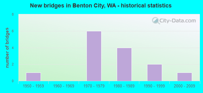
- New bridges - historical statistics
- 11950-1959
- 61970-1979
- 41980-1989
- 21990-1999
- 12000-2009
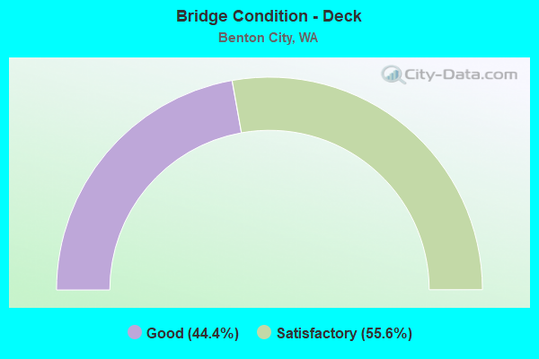
- Bridge Condition - Deck
- 44.4%Good
- 55.6%Satisfactory
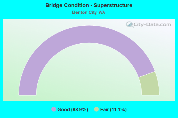
- Bridge Condition - Superstructure
- 88.9%Good
- 11.1%Fair
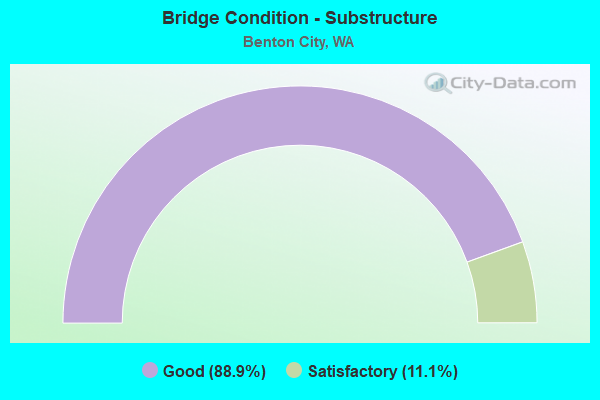
- Bridge Condition - Substructure
- 88.9%Good
- 11.1%Satisfactory
Find on map >> Show street view
Structure Number: 9444A, Location: 13.7 E JCT SR 22 (Lat: 46.253389, Lng: -119.487056), Route carried "on" structure: Interstate 82, Year Built: 1973, Status: Open, Structure Length: 14.63m (48.00ft), Average Daily Traffic: 11,068 (year 2019), Truck Traffic: 21%, Average Future Daily Traffic: 14,078 (year 2039), Design Load: HS 20+Mod, Features Intersected: BN RY
Minimum Vertical Clearance: 30+ m (98+ ft), Kilometerpoint: 154.513, Lanes on structure: 2, Base Highway Network: Yes, Owner: State Highway Agency, Approaching Roadway Width: 12.8m (42.0ft), Skew: 4 degrees, Material/Design: Prestressed concrete continuous, Design/Construction: Stringer/Multi-beam, Number Of Spans In Main Unit: 4, Length of Maximum Span: 44.5m (146.0ft), Curb-To-Curb Width: 11.6m (38.1ft), Out-to-Out Width: 12.5m (41.0ft)
Condition: Deck: Satisfactory, Superstructure: Good, Substructure: Good, Operating Rating: 70.7 metric tons, Method Used To Determine Operating Rating: Load Factor (LF), Inventory Rating: 42.6 metric tons, Method Used To Determine Inventory Rating: Load Factor (LF), Structural Evaluation: Better than present minimum criteria, Deck Geometry: Equal to present minimum criteria, Underclear: Better than present minimum criteria, Approach Roadway Alignment: Equal to present desirable criteria, Length Of Structure Improvement: 14.63m (48.00ft), Designated Inspection Frequency: Every 48 months, Inspection Date: April 2018, Bridge Improvement Cost: $4,224,000, Roadway Improvement Cost: $845,000, Total Project Cost: $8,448,000 ( Estimate for 2014), Deck Structure Type: Concrete Cast-file-Place, Wearing Surface/Protective System: Wearing Surface: Latex Concrete
Find on map >> Show street view
Structure Number: 9444B, Location: 13.6 E JCT SR 22 (Lat: 46.253778, Lng: -119.487750), Route carried "on" structure: Interstate 82, Year Built: 1973, Status: Open, Structure Length: 14.63m (48.00ft), Average Daily Traffic: 11,068 (year 2019), Truck Traffic: 21%, Average Future Daily Traffic: 14,078 (year 2039), Design Load: HS 20+Mod, Features Intersected: BN RY
Minimum Vertical Clearance: 30+ m (98+ ft), Kilometerpoint: 154.433, Lanes on structure: 2, Base Highway Network: Yes, Owner: State Highway Agency, Approaching Roadway Width: 12.8m (42.0ft), Skew: 4 degrees, Material/Design: Prestressed concrete continuous, Design/Construction: Stringer/Multi-beam, Number Of Spans In Main Unit: 4, Length of Maximum Span: 44.5m (146.0ft), Curb-To-Curb Width: 11.6m (38.1ft), Out-to-Out Width: 12.5m (41.0ft)
Condition: Deck: Satisfactory, Superstructure: Good, Substructure: Good, Operating Rating: 70.7 metric tons, Method Used To Determine Operating Rating: Load Factor (LF), Inventory Rating: 42.6 metric tons, Method Used To Determine Inventory Rating: Load Factor (LF), Structural Evaluation: Better than present minimum criteria, Deck Geometry: Equal to present minimum criteria, Underclear: Equal to present minimum criteria, Approach Roadway Alignment: Equal to present desirable criteria, Length Of Structure Improvement: 14.63m (48.00ft), Designated Inspection Frequency: Every 48 months, Inspection Date: April 2018, Bridge Improvement Cost: $4,224,000, Roadway Improvement Cost: $845,000, Total Project Cost: $8,448,000 ( Estimate for 2014), Deck Structure Type: Concrete Cast-file-Place, Wearing Surface/Protective System: Wearing Surface: Latex Concrete
Find on map >> Show street view
Structure Number: 9444C, Location: JCT SR 224 (Lat: 46.251172, Lng: -119.475808), Route carried "on" structure: Interstate 82, Year Built: 1973, Status: Open, Structure Length: 5.09m (16.70ft), Average Daily Traffic: 9,404 (year 2019), Truck Traffic: 21%, Average Future Daily Traffic: 11,961 (year 2039), Design Load: HS 20+Mod, Features Intersected: SR 224
Minimum Vertical Clearance: 30+ m (98+ ft), Kilometerpoint: 155.430, Lanes on structure: 2, Lanes under structure: 2, Base Highway Network: Yes, Owner: State Highway Agency, Approaching Roadway Width: 11.6m (38.1ft), Material/Design: Prestressed concrete continuous, Design/Construction: Stringer/Multi-beam, Number Of Spans In Main Unit: 3, Length of Maximum Span: 19.8m (65.0ft), Curb-To-Curb Width: 11.6m (38.1ft), Out-to-Out Width: 12.5m (41.0ft)
Condition: Deck: Satisfactory, Superstructure: Good, Substructure: Good, Operating Rating: 59.0 metric tons, Method Used To Determine Operating Rating: Load Factor (LF), Inventory Rating: 34.5 metric tons, Method Used To Determine Inventory Rating: Load Factor (LF), Structural Evaluation: Better than present minimum criteria, Deck Geometry: Equal to present minimum criteria, Underclear: Superior to present desirable criteria, Approach Roadway Alignment: Equal to present desirable criteria, Length Of Structure Improvement: 5.09m (16.70ft), Designated Inspection Frequency: Every 48 months, Inspection Date: April 2018, Bridge Improvement Cost: $1,336,000, Roadway Improvement Cost: $267,000, Total Project Cost: $2,672,000 ( Estimate for 2014), Deck Structure Type: Concrete Cast-file-Place, Wearing Surface/Protective System: Wearing Surface: Latex Concrete
Find on map >> Show street view
Structure Number: 9444D, Location: JCT SR 224 (Lat: 46.251167, Lng: -119.475806), Route carried "on" structure: Interstate 82, Year Built: 1973, Status: Open, Structure Length: 5.09m (16.70ft), Average Daily Traffic: 9,404 (year 2019), Truck Traffic: 21%, Average Future Daily Traffic: 11,961 (year 2039), Design Load: HS 20+Mod, Features Intersected: SR 224
Minimum Vertical Clearance: 30+ m (98+ ft), Kilometerpoint: 155.430, Lanes on structure: 2, Lanes under structure: 2, Base Highway Network: Yes, Owner: State Highway Agency, Approaching Roadway Width: 11.6m (38.1ft), Material/Design: Prestressed concrete continuous, Design/Construction: Stringer/Multi-beam, Number Of Spans In Main Unit: 3, Length of Maximum Span: 19.8m (65.0ft), Curb-To-Curb Width: 11.6m (38.1ft), Out-to-Out Width: 12.5m (41.0ft)
Condition: Deck: Satisfactory, Superstructure: Good, Substructure: Good, Operating Rating: 59.0 metric tons, Method Used To Determine Operating Rating: Load Factor (LF), Inventory Rating: 34.5 metric tons, Method Used To Determine Inventory Rating: Load Factor (LF), Structural Evaluation: Better than present minimum criteria, Deck Geometry: Equal to present minimum criteria, Underclear: Superior to present desirable criteria, Approach Roadway Alignment: Equal to present desirable criteria, Length Of Structure Improvement: 5.09m (16.70ft), Designated Inspection Frequency: Every 48 months, Inspection Date: April 2018, Bridge Improvement Cost: $1,336,000, Roadway Improvement Cost: $267,000, Total Project Cost: $2,672,000 ( Estimate for 2014), Deck Structure Type: Concrete Cast-file-Place, Wearing Surface/Protective System: Wearing Surface: Latex Concrete
Find on map >> Show street view
Structure Number: 13204A, Location: 11.3 E JCT SR 22 (Lat: 46.264200, Lng: -119.534714), Route carried "on" structure: County highway , Year Built: 1987, Status: Open, Structure Length: 7.44m (24.41ft), Average Daily Traffic: 282 (year 2012), Truck Traffic: 5%, Average Future Daily Traffic: 316 (year 2036), Design Load: HS 20+Mod, Features Intersected: I-82, Facility Carried by Structure: W YAKITAT RD NW
Minimum Vertical Clearance: 30+ m (98+ ft), Kilometerpoint: 0.080, Lanes on structure: 2, Lanes under structure: 4, Owner: State Highway Agency, Approaching Roadway Width: 8.5m (27.9ft), Material/Design: Prestressed concrete continuous, Design/Construction: Stringer/Multi-beam, Number Of Spans In Main Unit: 2, Length of Maximum Span: 39.6m (129.9ft), Curb-To-Curb Width: 8.5m (27.9ft), Out-to-Out Width: 9.4m (30.8ft)
Condition: Deck: Good, Superstructure: Good, Substructure: Good, Operating Rating: 74.4 metric tons, Method Used To Determine Operating Rating: Load Factor (LF), Inventory Rating: 43.5 metric tons, Method Used To Determine Inventory Rating: Load Factor (LF), Structural Evaluation: Better than present minimum criteria, Deck Geometry: Equal to present minimum criteria, Underclear: Better than present minimum criteria, Approach Roadway Alignment: Equal to present desirable criteria, Length Of Structure Improvement: 7.44m (24.41ft), Designated Inspection Frequency: Every 48 months, Inspection Date: April 2018, Bridge Improvement Cost: $1,464,000, Roadway Improvement Cost: $293,000, Total Project Cost: $2,928,000 ( Estimate for 2014), Deck Structure Type: Concrete Cast-file-Place, Wearing Surface/Protective System: Wearing Surface: Monolithic Concrete, Deck Protection: Epoxy Coated Reinforcing
Find on map >> Show street view
Structure Number: 13204B, Location: 12.1 E JCT SR 22 (Lat: 46.260222, Lng: -119.517278), Route carried "on" structure: Interstate 82, Year Built: 1987, Status: Open, Structure Length: 0.82m (2.69ft), Average Daily Traffic: 22,135 (year 2019), Truck Traffic: 21%, Average Future Daily Traffic: 28,155 (year 2039), Design Load: HS 20, Features Intersected: KENNEWICK MAIN CANAL
Minimum Vertical Clearance: 30+ m (98+ ft), Kilometerpoint: 152.035, Lanes on structure: 6, Base Highway Network: Yes, Owner: Bureau of Reclamation, Maintenance Responsibility: State Highway Agency, Approaching Roadway Width: 23.2m (76.1ft), Skew: 19 degrees, Material/Design: Concrete continuous, Design/Construction: Culvert, Number Of Spans In Main Unit: 2, Length of Maximum Span: 4.0m (13.1ft)
Condition: Channel: Very good, Culverts: Good, Operating Rating: 54.4 metric tons, Method Used To Determine Operating Rating: No rating analysis performed, Inventory Rating: 32.7 metric tons, Method Used To Determine Inventory Rating: No rating analysis performed, Structural Evaluation: Better than present minimum criteria, Waterway Adequacy: Equal to present desirable criteria, Approach Roadway Alignment: Equal to present desirable criteria, Length Of Structure Improvement: 0.82m (2.69ft), Designated Inspection Frequency: Every 48 months, Inspection Date: Febuary 2018, Bridge Improvement Cost: $421,000, Roadway Improvement Cost: $84,000, Total Project Cost: $842,000 ( Estimate for 2014)
Find on map >> Show street view
Structure Number: 81671, Location: 00.10 N SR 12 (Lat: 46.263828, Lng: -119.527433), Route carried "on" structure: County highway 18910, Year Built: 1981, Status: Open, Structure Length: 1.58m (5.18ft), Average Daily Traffic: 285 (year 2017), Truck Traffic: 25%, Average Future Daily Traffic: 300 (year 2038), Design Load: HS 20, Features Intersected: KID CANAL, Facility Carried by Structure: GRAHAM ROAD
Minimum Vertical Clearance: 30+ m (98+ ft), Kilometerpoint: 0.001, Lanes on structure: 2, Owner: County Highway Agency, Approaching Roadway Width: 8.5m (27.9ft), Material/Design: Prestressed concrete, Design/Construction: Stringer/Multi-beam, Number Of Spans In Main Unit: 1, Length of Maximum Span: 15.8m (51.8ft), Curb-To-Curb Width: 8.5m (27.9ft), Out-to-Out Width: 9.1m (29.9ft)
Condition: Deck: Good, Superstructure: Good, Substructure: Satisfactory, Channel: Very good, Operating Rating: 48.0 metric tons, Method Used To Determine Operating Rating: Load Factor (LF) rating reported by rating factor (RF) method using MS18 loading, Inventory Rating: 28.8 metric tons, Method Used To Determine Inventory Rating: Load Factor (LF) rating reported by rating factor (RF) method using MS18 loading, Structural Evaluation: Equal to present minimum criteria, Deck Geometry: Equal to present minimum criteria, Waterway Adequacy: Equal to present desirable criteria, Approach Roadway Alignment: Equal to present minimum criteria, Designated Inspection Frequency: Every 24 months, Inspection Date: Febuary 2020, Deck Structure Type: Other, Wearing Surface/Protective System: Wearing Surface: Bituminous
Find on map >> Show street view
Structure Number: 82446, Location: 0.03 N JCT SR 224 (Lat: 46.252361, Lng: -119.475444), Route carried "on" structure: State highway 225, Year Built: 1957, Status: Open, Structure Length: 12.19m (39.99ft), Average Daily Traffic: 10,554 (year 2019), Truck Traffic: 7%, Average Future Daily Traffic: 13,424 (year 2039), Design Load: HS 20, Features Intersected: YAKIMA RIVER
Minimum Vertical Clearance: 6.45m (21.16ft), Kilometerpoint: 0.048, Lanes on structure: 2, Owner: State Highway Agency, Approaching Roadway Width: 10.4m (34.1ft), Material/Design: Steel, Design/Construction: Stringer/Multi-beam, Number Of Spans In Main Unit: 1, Number Of Approach Spans: 6, Length of Maximum Span: 50.6m (166.0ft), Curb or Sidewalk Widths: Left: 1.1m (3.6ft), Right: 1.1m (3.6ft), Curb-To-Curb Width: 7.9m (25.9ft), Out-to-Out Width: 10.5m (34.4ft)
Condition: Deck: Satisfactory, Superstructure: Fair, Substructure: Good, Channel: Very good, Operating Rating: 21.7 metric tons, Method Used To Determine Operating Rating: Load and Resistance Factor Rating (LRFR) rating reported by rating factor(RF) method using HL-93 loadings, Inventory Rating: 16.8 metric tons, Method Used To Determine Inventory Rating: Load and Resistance Factor Rating (LRFR) rating reported by rating factor(RF) method using HL-93 loadings, Structural Evaluation: Meets minimum limits, Deck Geometry: High priority of corrective action, Waterway Adequacy: Equal to present desirable criteria, Approach Roadway Alignment: Equal to present desirable criteria, Length Of Structure Improvement: 12.19m (39.99ft), Designated Inspection Frequency: Every 24 months, Critical Feature Inspection Frequency: Every 24 months, Inspection Date: April 2021, Critical Feature Inspection Date: April 2021, Bridge Improvement Cost: $2,880,000, Roadway Improvement Cost: $576,000, Total Project Cost: $5,760,000 ( Estimate for 2014), Deck Structure Type: Concrete Cast-file-Place, Wearing Surface/Protective System: Wearing Surface: Bituminous
Find on map >> Show street view
Structure Number: 8403, Location: 00.25 SW WEBER CAN. (Lat: 46.241858, Lng: -119.481344), Route carried "on" structure: County highway 18650, Year Built: 1991, Status: Open, Structure Length: 1.58m (5.18ft), Average Daily Traffic: 85 (year 2017), Truck Traffic: 31%, Average Future Daily Traffic: 150 (year 2038), Design Load: HS 20, Features Intersected: KID CANAL, Facility Carried by Structure: MCBEE ROAD
Minimum Vertical Clearance: 30+ m (98+ ft), Kilometerpoint: 0.001, Lanes on structure: 2, Owner: County Highway Agency, Approaching Roadway Width: 7.3m (24.0ft), Material/Design: Prestressed concrete, Design/Construction: Stringer/Multi-beam, Number Of Spans In Main Unit: 1, Length of Maximum Span: 15.8m (51.8ft), Curb-To-Curb Width: 8.6m (28.2ft), Out-to-Out Width: 9.1m (29.9ft)
Condition: Deck: Good, Superstructure: Good, Substructure: Good, Channel: Very good, Operating Rating: 49.2 metric tons, Method Used To Determine Operating Rating: Load Factor (LF) rating reported by rating factor (RF) method using MS18 loading, Inventory Rating: 29.5 metric tons, Method Used To Determine Inventory Rating: Load Factor (LF) rating reported by rating factor (RF) method using MS18 loading, Structural Evaluation: Better than present minimum criteria, Deck Geometry: Better than present minimum criteria, Waterway Adequacy: Equal to present desirable criteria, Approach Roadway Alignment: Equal to present desirable criteria, Designated Inspection Frequency: Every 24 months, Inspection Date: Febuary 2020, Deck Structure Type: Other, Wearing Surface/Protective System: Wearing Surface: Bituminous
Find on map >> Show street view
Structure Number: 86726, Location: 215' E of RAYHILL RD (Lat: 46.277167, Lng: -119.563908), Route carried "on" structure: County highway 22150, Year Built: 1991, Status: Open, Structure Length: 0.73m (2.40ft), Average Daily Traffic: 2,177 (year 2016), Truck Traffic: 33%, Average Future Daily Traffic: 2,300 (year 2038), Features Intersected: KNOX CREEK, Facility Carried by Structure: OIEH
Minimum Vertical Clearance: 30+ m (98+ ft), Kilometerpoint: 0.001, Lanes on structure: 2, Owner: County Highway Agency, Approaching Roadway Width: 8.8m (28.9ft), Skew: 2 degrees, Material/Design: Steel, Design/Construction: Culvert, Number Of Spans In Main Unit: 2, Length of Maximum Span: 3.0m (9.8ft), Curb-To-Curb Width: 9.8m (32.2ft), Out-to-Out Width: 9.8m (32.2ft)
Condition: Channel: Very good, Culverts: Good, Operating Rating: 57.1 metric tons, Method Used To Determine Operating Rating: Load Factor (LF), Inventory Rating: 33.6 metric tons, Method Used To Determine Inventory Rating: Load Factor (LF), Structural Evaluation: Better than present minimum criteria, Deck Geometry: Meets minimum limits, Waterway Adequacy: Equal to present minimum criteria, Approach Roadway Alignment: Equal to present desirable criteria, Designated Inspection Frequency: Every 24 months, Inspection Date: Febuary 2020
Find on map >> Show street view
Structure Number: 87057, Location: 0.27 N JCT SR 224 (Lat: 46.255667, Lng: -119.475361), Route carried "on" structure: State highway 225, Year Built: 2003, Status: Open, Structure Length: 1.83m (6.00ft), Average Daily Traffic: 10,554 (year 2019), Truck Traffic: 7%, Average Future Daily Traffic: 13,424 (year 2039), Design Load: HS 20, Features Intersected: DRAINAGE CANAL
Minimum Vertical Clearance: 30+ m (98+ ft), Kilometerpoint: 0.418, Lanes on structure: 2, Owner: State Highway Agency, Approaching Roadway Width: 11.6m (38.1ft), Material/Design: Prestressed concrete, Design/Construction: Stringer/Multi-beam, Number Of Spans In Main Unit: 1, Length of Maximum Span: 17.7m (58.1ft), Curb-To-Curb Width: 12.3m (40.4ft), Out-to-Out Width: 13.2m (43.3ft)
Condition: Deck: Good, Superstructure: Good, Substructure: Good, Channel: Very good, Operating Rating: 87.1 metric tons, Method Used To Determine Operating Rating: Load Factor (LF), Inventory Rating: 48.1 metric tons, Method Used To Determine Inventory Rating: Load Factor (LF), Structural Evaluation: Better than present minimum criteria, Deck Geometry: Somewhat better than minimum adequacy, Waterway Adequacy: Equal to present desirable criteria, Approach Roadway Alignment: Equal to present desirable criteria, Length Of Structure Improvement: 1.83m (6.00ft), Designated Inspection Frequency: Every 48 months, Inspection Date: October 2020, Bridge Improvement Cost: $480,000, Roadway Improvement Cost: $96,000, Total Project Cost: $960,000 ( Estimate for 2014), Deck Structure Type: Concrete Cast-file-Place, Wearing Surface/Protective System: Wearing Surface: Bituminous, Membrane: Preformed Fabric, Deck Protection: Epoxy Coated Reinforcing
Find on map >> Show street view
Structure Number: 9444C, Location: JCT I-82 (Lat: 46.251172, Lng: -119.475808), Route carried "under" structure: State highway 224, Year Built: 1973, Structure Length: 0. m, Average Daily Traffic: 6,649 (year 2019), Truck Traffic: 11%, Features Intersected: SR 224, Facility Carried by Structure: I-82
Minimum Vertical Clearance: 5.61m (18.41ft), Kilometerpoint: 0.001, Lanes on structure: 2, Lanes under structure: 2, Material/Design: Prestressed concrete continuous, Design/Construction: Stringer/Multi-beam, Length of Maximum Span: 19.8m (65.0ft)
Find on map >> Show street view
Structure Number: 9444D, Location: JCT I-82 (Lat: 46.251167, Lng: -119.475806), Route carried "under" structure: State highway 224, Year Built: 1973, Structure Length: 0. m, Average Daily Traffic: 6,649 (year 2019), Truck Traffic: 11%, Features Intersected: SR 224, Facility Carried by Structure: I-82
Minimum Vertical Clearance: 5.08m (16.67ft), Kilometerpoint: 0.032, Lanes on structure: 2, Lanes under structure: 2, Material/Design: Prestressed concrete continuous, Design/Construction: Stringer/Multi-beam, Length of Maximum Span: 19.8m (65.0ft)
Find on map >> Show street view
Structure Number: 13204A, Location: 11.3 E JCT SR 22 (Lat: 46.264200, Lng: -119.534714), Route carried "under" structure: Interstate 82, Year Built: 1987, Structure Length: 0. m, Average Daily Traffic: 21,335 (year 2019), Truck Traffic: 21%, Features Intersected: I-82, Facility Carried by Structure: W YAKITAT RD NW
Minimum Vertical Clearance: 5.26m (17.26ft), Kilometerpoint: 150.651, Lanes on structure: 2, Lanes under structure: 4, Material/Design: Prestressed concrete continuous, Design/Construction: Stringer/Multi-beam, Length of Maximum Span: 39.6m (129.9ft)