Bridge Statistics for Beresford, South Dakota (SD)
Condition, Traffic, Stress, Structural Evaluation, Project Costs
- National Bridge Inventory (NBI) Statistics
- 28Number of bridges
- 177ft / 53.6mTotal length
- $2,854,000Total costs
- 96,109Total average daily traffic
- 20,440Total average daily truck traffic
- National Bridge Inventory (NBI) Registered Bridges for Beresford
- No street view available for this location
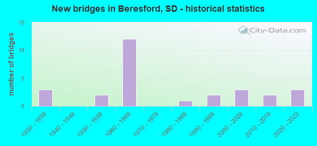
- New bridges - historical statistics
- 31930-1939
- 21950-1959
- 121960-1969
- 11980-1989
- 21990-1999
- 32000-2009
- 22010-2019
- 32020-2022
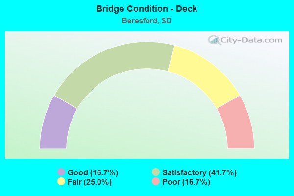
- Bridge Condition - Deck
- 16.7%Good
- 41.7%Satisfactory
- 25.0%Fair
- 16.7%Poor
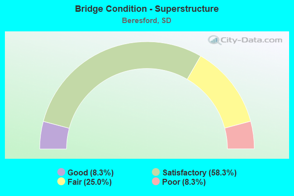
- Bridge Condition - Superstructure
- 8.3%Good
- 58.3%Satisfactory
- 25.0%Fair
- 8.3%Poor
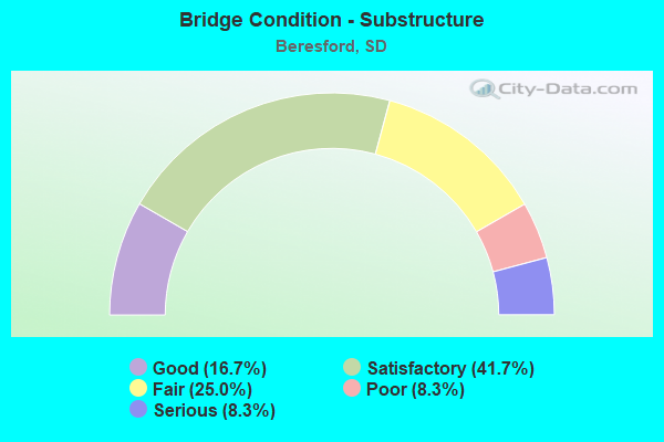
- Bridge Condition - Substructure
- 16.7%Good
- 41.7%Satisfactory
- 25.0%Fair
- 8.3%Poor
- 8.3%Serious
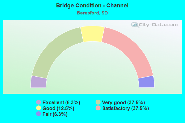
- Bridge Condition - Channel
- 6.3%Excellent
- 37.5%Very good
- 12.5%Good
- 37.5%Satisfactory
- 6.3%Fair
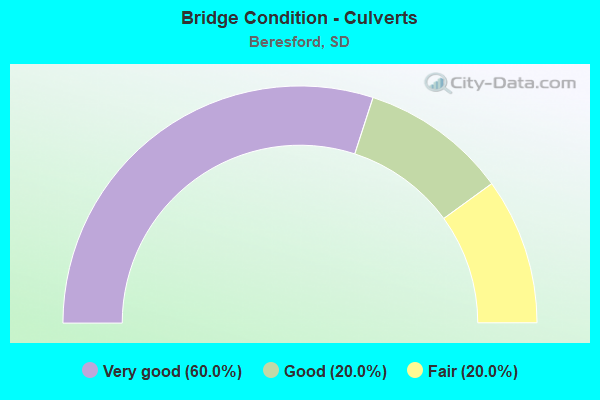
- Bridge Condition - Culverts
- 60.0%Very good
- 20.0%Good
- 20.0%Fair
Find on map >> Show street view
Structure Number: 14107, Location: 0.7E JCT SD 19 S (Lat: 43.083689, Lng: -96.847161), Route carried "on" structure: State highway 46, Year Built: 2020, Status: Open, Structure Length: 1.14m (3.74ft), Average Daily Traffic: 3,303 (year 2020), Truck Traffic: 9%, Average Future Daily Traffic: 4,284 (year 2040), Design Load: HL 93, Features Intersected: BLIND CK
Minimum Vertical Clearance: 30+ m (98+ ft), Kilometerpoint: 575.067, Lanes on structure: 2, Base Highway Network: Yes, Owner: State Highway Agency, Approaching Roadway Width: 12.2m (40.0ft), Material/Design: Concrete continuous, Design/Construction: Culvert, Number Of Spans In Main Unit: 3, Length of Maximum Span: 3.7m (12.1ft), Out-to-Out Width: 12.2m (40.0ft)
Condition: Channel: Very good, Culverts: Very good, Inventory Rating: 99.6 metric tons, Method Used To Determine Inventory Rating: Load and Resistance Factor (LRFR), Structural Evaluation: Equal to present desirable criteria, Waterway Adequacy: Superior to present desirable criteria, Approach Roadway Alignment: Superior to present desirable criteria, Designated Inspection Frequency: Every 48 months, Inspection Date: October 2020
Find on map >> Show street view
Structure Number: 4203929, Location: 2.6 W I 29 INTERCH (Lat: 43.083689, Lng: -96.847200), Route carried "on" structure: State highway 46, Year Built: 2020, Status: Open, Structure Length: 1.00m (3.28ft), Average Daily Traffic: 2,660 (year 2021), Truck Traffic: 13%, Average Future Daily Traffic: 4,365 (year 2041), Design Load: HL 93, Features Intersected: ASH CK
Minimum Vertical Clearance: 30+ m (98+ ft), Kilometerpoint: 583.371, Lanes on structure: 2, Base Highway Network: Yes, Owner: State Highway Agency, Approaching Roadway Width: 12.2m (40.0ft), Material/Design: Concrete, Design/Construction: Culvert, Number Of Spans In Main Unit: 3, Length of Maximum Span: 3.0m (9.8ft)
Condition: Channel: Very good, Culverts: Very good, Operating Rating: 58.1 metric tons, Method Used To Determine Operating Rating: Load and Resistance Factor (LRFR), Inventory Rating: 44.8 metric tons, Method Used To Determine Inventory Rating: Load and Resistance Factor (LRFR), Structural Evaluation: Equal to present desirable criteria, Waterway Adequacy: Superior to present desirable criteria, Approach Roadway Alignment: Superior to present desirable criteria, Designated Inspection Frequency: Every 48 months, Inspection Date: October 2020
Find on map >> Show street view
Structure Number: 42040262, Location: 3W & 2.8N of Beresford (Lat: 43.123756, Lng: -96.845294), Route carried "on" structure: Other road , Year Built: 2016, Status: Open, Structure Length: 0.80m (2.62ft), Average Daily Traffic: 48 (year 2019), Truck Traffic: 2%, Average Future Daily Traffic: 48 (year 2032), Design Load: HL 93, Features Intersected: Tributary to Blind Creek, Facility Carried by Structure: 468th Avenue
Minimum Vertical Clearance: 30+ m (98+ ft), Kilometerpoint: 0.000, Lanes on structure: 2, Owner: County Highway Agency, Approaching Roadway Width: 6.1m (20.0ft), Skew: 2 degrees, Material/Design: Concrete, Design/Construction: Culvert, Number Of Spans In Main Unit: 2, Length of Maximum Span: 3.9m (12.8ft)
Condition: Channel: Very good, Culverts: Good, Operating Rating: 31.0 metric tons, Method Used To Determine Operating Rating: Load and Resistance Factor (LRFR), Inventory Rating: 23.9 metric tons, Method Used To Determine Inventory Rating: Load and Resistance Factor (LRFR), Structural Evaluation: Equal to present minimum criteria, Waterway Adequacy: Equal to present desirable criteria, Approach Roadway Alignment: Equal to present desirable criteria, Designated Inspection Frequency: Every 24 months, Inspection Date: May 2020
Find on map >> Show street view
Structure Number: 42040273, Location: 3W & 1.7N of Beresford (Lat: 43.108547, Lng: -96.845264), Route carried "on" structure: Other road , Year Built: 1930, Status: Posted for load, Structure Length: 0.93m (3.05ft), Average Daily Traffic: 48 (year 2019), Truck Traffic: 2%, Average Future Daily Traffic: 48 (year 2032), Features Intersected: Tributary to Blind Creek, Facility Carried by Structure: 468th Avenue
Minimum Vertical Clearance: 30+ m (98+ ft), Kilometerpoint: 0.000, Lanes on structure: 2, Owner: County Highway Agency, Approaching Roadway Width: 5.2m (17.1ft), Material/Design: Concrete continuous, Design/Construction: Slab, Number Of Spans In Main Unit: 2, Length of Maximum Span: 4.5m (14.8ft), Curb-To-Curb Width: 5.5m (18.0ft), Out-to-Out Width: 5.9m (19.4ft)
Condition: Deck: Satisfactory, Superstructure: Satisfactory, Substructure: Fair, Channel: Satisfactory, Operating Rating: 24.5 metric tons, Method Used To Determine Operating Rating: Field evaluation and documented engineering judgment, Inventory Rating: 14.6 metric tons, Method Used To Determine Inventory Rating: Field evaluation and documented engineering judgment, Structural Evaluation: Meets minimum limits, Deck Geometry: Meets minimum limits, Waterway Adequacy: Better than present minimum criteria, Approach Roadway Alignment: Equal to present desirable criteria, Bridge Posting: Required (Relationship of Operating Rating to Maximum Legal Load: 20.0 - 29.9% below), Length Of Structure Improvement: 1.22m (4.00ft), Designated Inspection Frequency: Every 24 months, Inspection Date: May 2020, Bridge Improvement Cost: $626,000, Roadway Improvement Cost: $30,000, Total Project Cost: $656,000 ( Estimate for 2020), Deck Structure Type: Concrete Cast-file-Place, Wearing Surface/Protective System: Wearing Surface: Gravel
Find on map >> Show street view
Structure Number: 4204529, Location: 2.0 W I 29 INTERCH (Lat: 43.083639, Lng: -96.835781), Route carried "on" structure: State highway 46, Year Built: 2020, Status: Open, Structure Length: 0.87m (2.85ft), Average Daily Traffic: 3,303 (year 2020), Truck Traffic: 9%, Average Future Daily Traffic: 4,284 (year 2040), Design Load: HL 93, Features Intersected: ASH CK
Minimum Vertical Clearance: 30+ m (98+ ft), Kilometerpoint: 584.256, Lanes on structure: 2, Base Highway Network: Yes, Owner: State Highway Agency, Approaching Roadway Width: 12.2m (40.0ft), Material/Design: Concrete, Design/Construction: Culvert, Number Of Spans In Main Unit: 2, Length of Maximum Span: 4.3m (14.1ft)
Condition: Channel: Very good, Culverts: Very good, Operating Rating: 51.5 metric tons, Method Used To Determine Operating Rating: Load and Resistance Factor (LRFR), Inventory Rating: 39.7 metric tons, Method Used To Determine Inventory Rating: Load and Resistance Factor (LRFR), Structural Evaluation: Equal to present desirable criteria, Waterway Adequacy: Superior to present desirable criteria, Approach Roadway Alignment: Superior to present desirable criteria, Designated Inspection Frequency: Every 48 months, Inspection Date: October 2020
Find on map >> Show street view
Structure Number: 42050274, Location: 2W & 1.6N of Beresford (Lat: 43.106364, Lng: -96.825503), Route carried "on" structure: County highway , Year Built: 1950, Status: Open, Structure Length: 1.11m (3.64ft), Average Daily Traffic: 99 (year 2019), Truck Traffic: 2%, Average Future Daily Traffic: 99 (year 2032), Features Intersected: Tributary to Blind Creek, Facility Carried by Structure: 469th Avenue
Minimum Vertical Clearance: 30+ m (98+ ft), Kilometerpoint: 0.000, Lanes on structure: 2, Owner: County Highway Agency, Approaching Roadway Width: 7.3m (24.0ft), Material/Design: Concrete continuous, Design/Construction: Slab, Number Of Spans In Main Unit: 2, Length of Maximum Span: 5.1m (16.7ft), Curb-To-Curb Width: 7.4m (24.3ft), Out-to-Out Width: 8.2m (26.9ft)
Condition: Deck: Fair, Superstructure: Satisfactory, Substructure: Fair, Channel: Satisfactory, Operating Rating: 32.7 metric tons, Method Used To Determine Operating Rating: Field evaluation and documented engineering judgment, Inventory Rating: 24.5 metric tons, Method Used To Determine Inventory Rating: Field evaluation and documented engineering judgment, Structural Evaluation: Somewhat better than minimum adequacy, Deck Geometry: Equal to present minimum criteria, Waterway Adequacy: Equal to present desirable criteria, Approach Roadway Alignment: Meets minimum limits, Designated Inspection Frequency: Every 24 months, Inspection Date: May 2020, Deck Structure Type: Concrete Cast-file-Place, Wearing Surface/Protective System: Wearing Surface: Bituminous
Find on map >> Show street view
Structure Number: 42050287, Location: 2W & 0.3N of Beresford (Lat: 43.089783, Lng: -96.825472), Route carried "on" structure: County highway , Year Built: 1935, Year Reconstructed: 1957, Status: Posted for load, Structure Length: 0.70m (2.30ft), Average Daily Traffic: 261 (year 2019), Truck Traffic: 2%, Average Future Daily Traffic: 261 (year 2032), Features Intersected: Tributary to Ash Creek, Facility Carried by Structure: 469th Avenue
Minimum Vertical Clearance: 30+ m (98+ ft), Kilometerpoint: 0.000, Lanes on structure: 2, Owner: County Highway Agency, Approaching Roadway Width: 7.9m (25.9ft), Material/Design: Concrete continuous, Design/Construction: Slab, Number Of Spans In Main Unit: 2, Length of Maximum Span: 3.3m (10.8ft), Curb-To-Curb Width: 8.5m (27.9ft), Out-to-Out Width: 9.0m (29.5ft)
Condition: Deck: Fair, Superstructure: Satisfactory, Substructure: Poor, Channel: Good, Operating Rating: 24.5 metric tons, Method Used To Determine Operating Rating: Field evaluation and documented engineering judgment, Inventory Rating: 14.6 metric tons, Method Used To Determine Inventory Rating: Field evaluation and documented engineering judgment, Structural Evaluation: Meets minimum limits, Deck Geometry: Equal to present minimum criteria, Waterway Adequacy: Superior to present desirable criteria, Approach Roadway Alignment: Equal to present desirable criteria, Bridge Posting: Required (Relationship of Operating Rating to Maximum Legal Load: 20.0 - 29.9% below), Length Of Structure Improvement: 0.91m (2.99ft), Designated Inspection Frequency: Every 24 months, Inspection Date: May 2020, Bridge Improvement Cost: $498,000, Roadway Improvement Cost: $30,000, Total Project Cost: $528,000 ( Estimate for 2020), Deck Structure Type: Concrete Cast-file-Place, Wearing Surface/Protective System: Wearing Surface: Bituminous
Find on map >> Show street view
Structure Number: 4206526, Location: 3 N SD 46 INTERCHANGE (Lat: 43.127192, Lng: -96.796269), Route carried "on" structure: County highway , Year Built: 1961, Status: Open, Structure Length: 7.74m (25.39ft), Average Daily Traffic: 621 (year 2020), Truck Traffic: 3%, Average Future Daily Traffic: 621 (year 2040), Design Load: HS 20, Features Intersected: I029, Facility Carried by Structure: 294 ST (FAS 6116)
Minimum Vertical Clearance: 30+ m (98+ ft), Kilometerpoint: 0.000, Lanes on structure: 2, Lanes under structure: 4, Owner: State Highway Agency, Approaching Roadway Width: 9.1m (29.9ft), Material/Design: Steel continuous, Design/Construction: Stringer/Multi-beam, Number Of Spans In Main Unit: 4, Length of Maximum Span: 21.3m (69.9ft), Curb-To-Curb Width: 9.1m (29.9ft), Out-to-Out Width: 9.9m (32.5ft)
Condition: Deck: Satisfactory, Superstructure: Fair, Substructure: Satisfactory, Operating Rating: 42.1 metric tons, Method Used To Determine Operating Rating: Load Factor (LF), Inventory Rating: 25.2 metric tons, Method Used To Determine Inventory Rating: Load Factor (LF), Structural Evaluation: Somewhat better than minimum adequacy, Deck Geometry: Equal to present minimum criteria, Underclear: Somewhat better than minimum adequacy, Approach Roadway Alignment: Equal to present minimum criteria, Designated Inspection Frequency: Every 24 months, Inspection Date: March 2021, Deck Structure Type: Concrete Cast-file-Place, Wearing Surface/Protective System: Wearing Surface: Epoxy Overlay, Membrane: Epoxy
Find on map >> Show street view
Structure Number: 42065278, Location: 1.2 N SD 46 INTERCH (Lat: 43.101100, Lng: -96.796022), Route carried "on" structure: Interstate 29, Year Built: 1960, Status: Open, Structure Length: 0.72m (2.36ft), Average Daily Traffic: 13,790 (year 2020), Truck Traffic: 23%, Average Future Daily Traffic: 25,374 (year 2040), Design Load: HS 20+Mod, Features Intersected: CK
Minimum Vertical Clearance: 30+ m (98+ ft), Kilometerpoint: 78.085, Lanes on structure: 4, Base Highway Network: Yes, Owner: State Highway Agency, Approaching Roadway Width: 24.4m (80.1ft), Skew: 24 degrees, Material/Design: Concrete continuous, Design/Construction: Culvert, Number Of Spans In Main Unit: 2, Length of Maximum Span: 3.4m (11.2ft)
Condition: Channel: Good, Culverts: Good, Structural Evaluation: Better than present minimum criteria, Waterway Adequacy: Equal to present desirable criteria, Approach Roadway Alignment: Equal to present desirable criteria, Designated Inspection Frequency: Every 48 months, Inspection Date: August 2021
Find on map >> Show street view
Structure Number: 4210327, Location: 2N & 2.3E of Beresford (Lat: 43.112719, Lng: -96.719925), Route carried "on" structure: Other road , Year Built: 1996, Status: Open, Structure Length: 0.75m (2.46ft), Average Daily Traffic: 47 (year 2019), Truck Traffic: 2%, Average Future Daily Traffic: 47 (year 2032), Design Load: HS 20+Mod, Features Intersected: West Brule Creek, Facility Carried by Structure: 295th Street
Minimum Vertical Clearance: 30+ m (98+ ft), Kilometerpoint: 0.000, Lanes on structure: 2, Owner: County Highway Agency, Approaching Roadway Width: 8.5m (27.9ft), Material/Design: Concrete continuous, Design/Construction: Culvert, Number Of Spans In Main Unit: 2, Length of Maximum Span: 3.7m (12.1ft)
Condition: Channel: Fair, Culverts: Very good, Operating Rating: 81.3 metric tons, Method Used To Determine Operating Rating: Load and Resistance Factor (LRFR), Inventory Rating: 62.7 metric tons, Method Used To Determine Inventory Rating: Load and Resistance Factor (LRFR), Structural Evaluation: Equal to present desirable criteria, Waterway Adequacy: Equal to present desirable criteria, Approach Roadway Alignment: Equal to present desirable criteria, Designated Inspection Frequency: Every 48 months, Inspection Date: May 2020
Find on map >> Show street view
Structure Number: 42110276, Location: 3E & 1.4N of Beresford (Lat: 43.103986, Lng: -96.707133), Route carried "on" structure: Other road , Year Built: 1936, Status: Posted for load, Structure Length: 1.46m (4.79ft), Average Daily Traffic: 35 (year 2019), Truck Traffic: 2%, Average Future Daily Traffic: 35 (year 2032), Features Intersected: West Brule Creek, Facility Carried by Structure: 475th Avenue
Minimum Vertical Clearance: 30+ m (98+ ft), Kilometerpoint: 0.000, Lanes on structure: 2, Owner: County Highway Agency, Approaching Roadway Width: 5.5m (18.0ft), Material/Design: Steel, Design/Construction: Stringer/Multi-beam, Number Of Spans In Main Unit: 2, Length of Maximum Span: 7.0m (23.0ft), Curb-To-Curb Width: 5.5m (18.0ft), Out-to-Out Width: 5.9m (19.4ft)
Condition: Deck: Fair, Superstructure: Satisfactory, Substructure: Satisfactory, Channel: Satisfactory, Operating Rating: 12.6 metric tons, Method Used To Determine Operating Rating: Load and Resistance Factor (LRFR), Inventory Rating: 9.7 metric tons, Method Used To Determine Inventory Rating: Load and Resistance Factor (LRFR), Structural Evaluation: High priority of replacement, Deck Geometry: Meets minimum limits, Waterway Adequacy: Equal to present minimum criteria, Approach Roadway Alignment: Somewhat better than minimum adequacy, Bridge Posting: Required (Relationship of Operating Rating to Maximum Legal Load: > 39.9% below), Length Of Structure Improvement: 1.52m (4.99ft), Designated Inspection Frequency: Every 24 months, Inspection Date: May 2020, Bridge Improvement Cost: $540,000, Roadway Improvement Cost: $30,000, Total Project Cost: $570,000 ( Estimate for 2020), Deck Structure Type: Concrete Cast-file-Place, Wearing Surface/Protective System: Wearing Surface: Gravel
Find on map >> Show street view
Structure Number: 6400505, Location: 5 S SD 46 INTERCHANGE (Lat: 43.011322, Lng: -96.795853), Route carried "on" structure: Interstate 29, Year Built: 1960, Status: Posted for load, Structure Length: 3.63m (11.91ft), Average Daily Traffic: 7,530 (year 2021), Truck Traffic: 27%, Average Future Daily Traffic: 12,394 (year 2041), Design Load: HS 20+Mod, Features Intersected: 302 ST (FAS 6372)
Minimum Vertical Clearance: 30+ m (98+ ft), Kilometerpoint: 68.091, Lanes on structure: 2, Lanes under structure: 2, Base Highway Network: Yes, Owner: State Highway Agency, Approaching Roadway Width: 12.2m (40.0ft), Material/Design: Concrete continuous, Design/Construction: Slab, Number Of Spans In Main Unit: 3, Length of Maximum Span: 13.0m (42.7ft), Curb-To-Curb Width: 12.2m (40.0ft), Out-to-Out Width: 13.5m (44.3ft)
Condition: Deck: Good, Superstructure: Satisfactory, Substructure: Good, Operating Rating: 35.4 metric tons, Method Used To Determine Operating Rating: Load Factor (LF), Inventory Rating: 21.2 metric tons, Method Used To Determine Inventory Rating: Load Factor (LF), Structural Evaluation: Somewhat better than minimum adequacy, Deck Geometry: Better than present minimum criteria, Underclear: Somewhat better than minimum adequacy, Approach Roadway Alignment: Equal to present desirable criteria, Designated Inspection Frequency: Every 24 months, Inspection Date: December 2021, Deck Structure Type: Concrete Cast-file-Place, Wearing Surface/Protective System: Wearing Surface: Low Slump Concrete
Find on map >> Show street view
Structure Number: 64006, Location: SD 46 INTERCHANGE (Lat: 43.083706, Lng: -96.795714), Route carried "on" structure: State highway 46, Year Built: 2000, Status: Open, Structure Length: 7.22m (23.69ft), Average Daily Traffic: 4,651 (year 2021), Truck Traffic: 8%, Average Future Daily Traffic: 7,163 (year 2041), Design Load: HS 25 or greater, Features Intersected: I029
Minimum Vertical Clearance: 30+ m (98+ ft), Kilometerpoint: 587.571, Lanes on structure: 2, Lanes under structure: 4, Base Highway Network: Yes, Owner: State Highway Agency, Approaching Roadway Width: 17.0m (55.8ft), Material/Design: Prestressed concrete continuous, Design/Construction: Stringer/Multi-beam, Number Of Spans In Main Unit: 2, Length of Maximum Span: 35.8m (117.5ft), Curb or Sidewalk Widths: Left: 2.0m (6.6ft), Right: 0.0m, Curb-To-Curb Width: 17.0m (55.8ft), Out-to-Out Width: 19.8m (65.0ft)
Condition: Deck: Good, Superstructure: Good, Substructure: Good, Operating Rating: 76.8 metric tons, Method Used To Determine Operating Rating: Load Factor (LF), Inventory Rating: 46.0 metric tons, Method Used To Determine Inventory Rating: Load Factor (LF), Structural Evaluation: Better than present minimum criteria, Deck Geometry: Superior to present desirable criteria, Underclear: Better than present minimum criteria, Approach Roadway Alignment: Superior to present desirable criteria, Designated Inspection Frequency: Every 24 months, Inspection Date: August 2021, Deck Structure Type: Concrete Cast-file-Place, Wearing Surface/Protective System: Wearing Surface: Monolithic Concrete, Deck Protection: Epoxy Coated Reinforcing
Find on map >> Show street view
Structure Number: 6400601, Location: 1 S SD 46 INTERCH (Lat: 43.069172, Lng: -96.795400), Route carried "on" structure: County highway , Year Built: 1960, Status: Open, Structure Length: 7.74m (25.39ft), Average Daily Traffic: 95 (year 2020), Truck Traffic: 2%, Average Future Daily Traffic: 95 (year 2040), Design Load: HS 20, Features Intersected: I029, Facility Carried by Structure: 298 ST
Minimum Vertical Clearance: 30+ m (98+ ft), Kilometerpoint: 0.000, Lanes on structure: 2, Lanes under structure: 4, Owner: State Highway Agency, Approaching Roadway Width: 9.1m (29.9ft), Material/Design: Steel continuous, Design/Construction: Stringer/Multi-beam, Number Of Spans In Main Unit: 4, Length of Maximum Span: 21.3m (69.9ft), Curb-To-Curb Width: 9.1m (29.9ft), Out-to-Out Width: 9.9m (32.5ft)
Condition: Deck: Satisfactory, Superstructure: Satisfactory, Substructure: Satisfactory, Operating Rating: 53.2 metric tons, Method Used To Determine Operating Rating: Load Factor (LF), Inventory Rating: 31.8 metric tons, Method Used To Determine Inventory Rating: Load Factor (LF), Structural Evaluation: Equal to present minimum criteria, Deck Geometry: Better than present minimum criteria, Underclear: Equal to present minimum criteria, Approach Roadway Alignment: Somewhat better than minimum adequacy, Designated Inspection Frequency: Every 24 months, Inspection Date: March 2020, Deck Structure Type: Concrete Cast-file-Place, Wearing Surface/Protective System: Wearing Surface: Bituminous
Find on map >> Show street view
Structure Number: 6400603, Location: 3 S SD 46 INTERCH (Lat: 43.040111, Lng: -96.795125), Route carried "on" structure: County highway , Year Built: 1960, Status: Open, Structure Length: 7.74m (25.39ft), Average Daily Traffic: 115 (year 2020), Truck Traffic: 2%, Average Future Daily Traffic: 115 (year 2040), Design Load: HS 20, Features Intersected: I029, Facility Carried by Structure: 300 ST
Minimum Vertical Clearance: 30+ m (98+ ft), Kilometerpoint: 0.000, Lanes on structure: 2, Lanes under structure: 4, Owner: State Highway Agency, Approaching Roadway Width: 9.1m (29.9ft), Material/Design: Steel continuous, Design/Construction: Stringer/Multi-beam, Number Of Spans In Main Unit: 4, Length of Maximum Span: 21.3m (69.9ft), Curb-To-Curb Width: 9.1m (29.9ft), Out-to-Out Width: 9.9m (32.5ft)
Condition: Deck: Poor, Superstructure: Fair, Substructure: Satisfactory, Operating Rating: 49.9 metric tons, Method Used To Determine Operating Rating: Load Factor (LF), Inventory Rating: 29.9 metric tons, Method Used To Determine Inventory Rating: Load Factor (LF), Structural Evaluation: Somewhat better than minimum adequacy, Deck Geometry: Equal to present minimum criteria, Underclear: Equal to present minimum criteria, Approach Roadway Alignment: Equal to present minimum criteria, Length Of Structure Improvement: 7.62m (25.00ft), Designated Inspection Frequency: Every 24 months, Inspection Date: March 2020, Bridge Improvement Cost: $900,000, Roadway Improvement Cost: $50,000, Total Project Cost: $1,000,000, Deck Structure Type: Concrete Cast-file-Place, Wearing Surface/Protective System: Wearing Surface: Bituminous, Membrane: Preformed Fabric
Find on map >> Show street view
Structure Number: 6400605, Location: 5 S SD 46 INTERCHANGE (Lat: 43.011319, Lng: -96.795531), Route carried "on" structure: Interstate 29, Year Built: 1960, Status: Posted for load, Structure Length: 3.63m (11.91ft), Average Daily Traffic: 7,530 (year 2021), Truck Traffic: 27%, Average Future Daily Traffic: 12,394 (year 2041), Design Load: HS 20+Mod, Features Intersected: 302 ST (FAS 6372)
Minimum Vertical Clearance: 30+ m (98+ ft), Kilometerpoint: 68.091, Lanes on structure: 2, Lanes under structure: 2, Base Highway Network: Yes, Owner: State Highway Agency, Approaching Roadway Width: 12.2m (40.0ft), Material/Design: Concrete continuous, Design/Construction: Slab, Number Of Spans In Main Unit: 3, Length of Maximum Span: 13.0m (42.7ft), Curb-To-Curb Width: 12.2m (40.0ft), Out-to-Out Width: 13.5m (44.3ft)
Condition: Deck: Satisfactory, Superstructure: Satisfactory, Substructure: Satisfactory, Operating Rating: 35.4 metric tons, Method Used To Determine Operating Rating: Load Factor (LF), Inventory Rating: 21.2 metric tons, Method Used To Determine Inventory Rating: Load Factor (LF), Structural Evaluation: Somewhat better than minimum adequacy, Deck Geometry: Better than present minimum criteria, Underclear: Somewhat better than minimum adequacy, Approach Roadway Alignment: Equal to present desirable criteria, Designated Inspection Frequency: Every 24 months, Inspection Date: December 2021, Deck Structure Type: Concrete Cast-file-Place, Wearing Surface/Protective System: Wearing Surface: Low Slump Concrete
Find on map >> Show street view
Structure Number: 6401605, Location: 5S BERESFORD (Lat: 43.011192, Lng: -96.773783), Route carried "on" structure: County highway , Year Built: 1960, Status: Open, Structure Length: 0.63m (2.07ft), Average Daily Traffic: 450 (year 2019), Truck Traffic: 3%, Average Future Daily Traffic: 450 (year 2032), Design Load: H 15, Features Intersected: CK, Facility Carried by Structure: 47160 302 ST
Minimum Vertical Clearance: 30+ m (98+ ft), Kilometerpoint: 0.000, Lanes on structure: 2, Owner: County Highway Agency, Approaching Roadway Width: 7.9m (25.9ft), Material/Design: Concrete continuous, Design/Construction: Culvert, Number Of Spans In Main Unit: 2, Length of Maximum Span: 3.0m (9.8ft)
Condition: Channel: Satisfactory, Culverts: Fair, Operating Rating: 32.7 metric tons, Method Used To Determine Operating Rating: Field evaluation and documented engineering judgment, Inventory Rating: 24.5 metric tons, Method Used To Determine Inventory Rating: Field evaluation and documented engineering judgment, Structural Evaluation: Somewhat better than minimum adequacy, Waterway Adequacy: Equal to present desirable criteria, Approach Roadway Alignment: Equal to present desirable criteria, Length Of Structure Improvement: 3.96m (12.99ft), Designated Inspection Frequency: Every 24 months, Inspection Date: June 2020, Bridge Improvement Cost: $17,000, Roadway Improvement Cost: $5,000, Total Project Cost: $25,000 ( Estimate for 2014)
Find on map >> Show street view
Structure Number: 6402503, Location: 2S & 0.5E BERESFORD (Lat: 43.040261, Lng: -96.755136), Route carried "on" structure: County highway , Year Built: 1950, Status: Open, Structure Length: 0.89m (2.92ft), Average Daily Traffic: 35 (year 2019), Truck Traffic: 2%, Average Future Daily Traffic: 35 (year 2032), Features Intersected: CK, Facility Carried by Structure: 47250 300 STR.
Minimum Vertical Clearance: 30+ m (98+ ft), Kilometerpoint: 0.000, Lanes on structure: 2, Owner: County Highway Agency, Approaching Roadway Width: 7.3m (24.0ft), Skew: 4 degrees, Material/Design: Concrete continuous, Design/Construction: Culvert, Number Of Spans In Main Unit: 2, Length of Maximum Span: 4.3m (14.1ft)
Condition: Channel: Satisfactory, Culverts: Fair, Operating Rating: 32.7 metric tons, Method Used To Determine Operating Rating: Field evaluation and documented engineering judgment, Inventory Rating: 24.5 metric tons, Method Used To Determine Inventory Rating: Field evaluation and documented engineering judgment, Structural Evaluation: Somewhat better than minimum adequacy, Waterway Adequacy: Equal to present desirable criteria, Approach Roadway Alignment: Equal to present desirable criteria, Length Of Structure Improvement: 3.96m (12.99ft), Designated Inspection Frequency: Every 24 months, Inspection Date: June 2020, Bridge Improvement Cost: $17,000, Roadway Improvement Cost: $5,000, Total Project Cost: $25,000 ( Estimate for 2014), Wearing Surface/Protective System: Wearing Surface: Other
Find on map >> Show street view
Structure Number: 64030034, Location: 1E & 2.4S BERESFORD (Lat: 43.034600, Lng: -96.746481), Route carried "on" structure: County highway , Year Built: 1991, Status: Posted for load, Structure Length: 0.97m (3.18ft), Average Daily Traffic: 50 (year 2019), Truck Traffic: 2%, Average Future Daily Traffic: 50 (year 2032), Features Intersected: CK, Facility Carried by Structure: 30040 473 AVE.
Minimum Vertical Clearance: 30+ m (98+ ft), Kilometerpoint: 0.000, Lanes on structure: 2, Owner: County Highway Agency, Approaching Roadway Width: 8.5m (27.9ft), Material/Design: Steel continuous, Design/Construction: Stringer/Multi-beam, Number Of Spans In Main Unit: 2, Length of Maximum Span: 4.8m (15.7ft), Curb-To-Curb Width: 8.4m (27.6ft), Out-to-Out Width: 8.5m (27.9ft)
Condition: Deck: Poor, Superstructure: Poor, Substructure: Serious, Channel: Very good, Inventory Rating: 68.9 metric tons, Method Used To Determine Inventory Rating: Load Factor (LF), Structural Evaluation: High priority of corrective action, Deck Geometry: Equal to present minimum criteria, Waterway Adequacy: Equal to present minimum criteria, Approach Roadway Alignment: Equal to present desirable criteria, Bridge Posting: Required (Relationship of Operating Rating to Maximum Legal Load: 30.0 - 39.9% below), Length Of Structure Improvement: 3.96m (12.99ft), Designated Inspection Frequency: Every 12 months, Inspection Date: July 2021, Bridge Improvement Cost: $17,000, Roadway Improvement Cost: $5,000, Total Project Cost: $25,000 ( Estimate for 2014), Deck Structure Type: Wood or Timber, Wearing Surface/Protective System: Wearing Surface: Gravel
Find on map >> Show street view
Structure Number: 6403804, Location: 3S & 1.8E BERESFORD (Lat: 43.025992, Lng: -96.730389), Route carried "on" structure: County highway , Year Built: 2010, Status: Open, Structure Length: 1.36m (4.46ft), Average Daily Traffic: 50 (year 2019), Truck Traffic: 2%, Average Future Daily Traffic: 50 (year 2032), Design Load: HL 93, Features Intersected: WEST BRULE CK, Facility Carried by Structure: 47380 301ST ST
Minimum Vertical Clearance: 30+ m (98+ ft), Kilometerpoint: 0.000, Lanes on structure: 2, Owner: County Highway Agency, Approaching Roadway Width: 7.9m (25.9ft), Material/Design: Concrete continuous, Design/Construction: Culvert, Number Of Spans In Main Unit: 3, Length of Maximum Span: 4.3m (14.1ft)
Condition: Channel: Very good, Culverts: Very good, Operating Rating: 45.3 metric tons, Method Used To Determine Operating Rating: Load and Resistance Factor (LRFR), Inventory Rating: 34.9 metric tons, Method Used To Determine Inventory Rating: Load and Resistance Factor (LRFR), Structural Evaluation: Equal to present desirable criteria, Waterway Adequacy: Equal to present desirable criteria, Approach Roadway Alignment: Superior to present desirable criteria, Designated Inspection Frequency: Every 24 months, Inspection Date: July 2020
Find on map >> Show street view
Structure Number: 64040037, Location: 2E & 2.7S BERESFORD (Lat: 43.030347, Lng: -96.726692), Route carried "on" structure: County highway , Year Built: 1982, Status: Posted for load, Structure Length: 1.48m (4.86ft), Average Daily Traffic: 40 (year 2019), Truck Traffic: 2%, Average Future Daily Traffic: 40 (year 2032), Design Load: HS 20, Features Intersected: WEST BRULE CK, Facility Carried by Structure: 30070 474TH AVE
Minimum Vertical Clearance: 30+ m (98+ ft), Kilometerpoint: 0.000, Lanes on structure: 2, Owner: County Highway Agency, Approaching Roadway Width: 4.9m (16.1ft), Material/Design: Steel, Design/Construction: Stringer/Multi-beam, Number Of Spans In Main Unit: 2, Length of Maximum Span: 7.6m (24.9ft), Curb-To-Curb Width: 8.2m (26.9ft), Out-to-Out Width: 8.5m (27.9ft)
Condition: Deck: Satisfactory, Superstructure: Fair, Substructure: Fair, Channel: Satisfactory, Operating Rating: 50.3 metric tons, Method Used To Determine Operating Rating: Load Factor (LF), Inventory Rating: 30.1 metric tons, Method Used To Determine Inventory Rating: Load Factor (LF), Structural Evaluation: Somewhat better than minimum adequacy, Deck Geometry: Equal to present minimum criteria, Waterway Adequacy: Equal to present minimum criteria, Approach Roadway Alignment: Equal to present minimum criteria, Length Of Structure Improvement: 3.96m (12.99ft), Designated Inspection Frequency: Every 24 months, Inspection Date: July 2020, Bridge Improvement Cost: $17,000, Roadway Improvement Cost: $5,000, Total Project Cost: $25,000 ( Estimate for 2014), Deck Structure Type: Wood or Timber, Wearing Surface/Protective System: Wearing Surface: Gravel
Find on map >> Show street view
Structure Number: 6404601, Location: 2.6E BERESFORD (Lat: 43.069317, Lng: -96.713606), Route carried "on" structure: County highway , Year Built: 2008, Status: Open, Structure Length: 1.13m (3.71ft), Average Daily Traffic: 110 (year 2019), Truck Traffic: 2%, Average Future Daily Traffic: 110 (year 2032), Design Load: HS 20+Mod, Features Intersected: WEST BRULE CK, Facility Carried by Structure: 47440 298TH ST
Minimum Vertical Clearance: 30+ m (98+ ft), Kilometerpoint: 0.000, Lanes on structure: 2, Owner: County Highway Agency, Approaching Roadway Width: 8.5m (27.9ft), Skew: 2 degrees, Material/Design: Concrete continuous, Design/Construction: Culvert, Number Of Spans In Main Unit: 2, Length of Maximum Span: 3.6m (11.8ft)
Condition: Channel: Excellent, Culverts: Very good, Operating Rating: 42.3 metric tons, Method Used To Determine Operating Rating: Load and Resistance Factor (LRFR), Inventory Rating: 32.6 metric tons, Method Used To Determine Inventory Rating: Field evaluation and documented engineering judgment, Structural Evaluation: Equal to present desirable criteria, Waterway Adequacy: Superior to present desirable criteria, Approach Roadway Alignment: Superior to present desirable criteria, Designated Inspection Frequency: Every 48 months, Inspection Date: July 2018
Find on map >> Show street view
Structure Number: 4206526, Location: 3 N SD 46 INTERCHANGE (Lat: 43.127192, Lng: -96.796269), Route carried "under" structure: Interstate 29, Year Built: 1961, Structure Length: 0. m, Average Daily Traffic: 13,790 (year 2020), Truck Traffic: 23%, Features Intersected: I029
Minimum Vertical Clearance: 4.93m (16.17ft), Kilometerpoint: 80.966, Lanes on structure: 2, Lanes under structure: 4, Material/Design: Steel continuous, Design/Construction: Stringer/Multi-beam, Length of Maximum Span: 21.3m (69.9ft)
Find on map >> Show street view
Structure Number: 6400505, Location: 5 S SD 46 INTERCHANGE (Lat: 43.011322, Lng: -96.795853), Route carried "under" structure: County highway , Year Built: 1960, Structure Length: 0. m, Average Daily Traffic: 369 (year 2020), Truck Traffic: 1%, Features Intersected: 302 ST (FAS 6372), Facility Carried by Structure: I029 S
Minimum Vertical Clearance: 4.80m (15.75ft), Kilometerpoint: 0.000, Lanes on structure: 2, Lanes under structure: 2, Material/Design: Concrete continuous, Design/Construction: Slab, Length of Maximum Span: 13.0m (42.7ft)
Find on map >> Show street view
Structure Number: 64006, Location: SD 46 INTERCHANGE (Lat: 43.083706, Lng: -96.795714), Route carried "under" structure: Interstate 29, Year Built: 2000, Structure Length: 0. m, Average Daily Traffic: 13,790 (year 2020), Truck Traffic: 23%, Features Intersected: I029, Facility Carried by Structure: SD046
Minimum Vertical Clearance: 5.31m (17.42ft), Kilometerpoint: 76.138, Lanes on structure: 2, Lanes under structure: 4, Material/Design: Prestressed concrete continuous, Design/Construction: Stringer/Multi-beam, Length of Maximum Span: 35.8m (117.5ft)
Find on map >> Show street view
Structure Number: 6400601, Location: 1 S SD 46 INTERCH (Lat: 43.069172, Lng: -96.795400), Route carried "under" structure: Interstate 29, Year Built: 1960, Structure Length: 0. m, Average Daily Traffic: 11,460 (year 2020), Truck Traffic: 24%, Features Intersected: I029
Minimum Vertical Clearance: 5.26m (17.26ft), Kilometerpoint: 74.529, Lanes on structure: 2, Lanes under structure: 4, Material/Design: Steel continuous, Design/Construction: Stringer/Multi-beam, Length of Maximum Span: 21.3m (69.9ft)
Find on map >> Show street view
Structure Number: 6400603, Location: 3 S SD 46 INTERCH (Lat: 43.040111, Lng: -96.795125), Route carried "under" structure: Interstate 29, Year Built: 1960, Structure Length: 0. m, Average Daily Traffic: 11,460 (year 2020), Truck Traffic: 24%, Features Intersected: I029, Facility Carried by Structure: 300 ST
Minimum Vertical Clearance: 5.23m (17.16ft), Kilometerpoint: 71.294, Lanes on structure: 2, Lanes under structure: 4, Material/Design: Steel continuous, Design/Construction: Stringer/Multi-beam, Length of Maximum Span: 21.3m (69.9ft)
Find on map >> Show street view
Structure Number: 6400605, Location: 5 S SD 46 INTERCHANGE (Lat: 43.011319, Lng: -96.795531), Route carried "under" structure: County highway , Year Built: 1960, Structure Length: 0. m, Average Daily Traffic: 369 (year 2020), Truck Traffic: 1%, Features Intersected: 302 ST (FAS 6372), Facility Carried by Structure: I029 N
Minimum Vertical Clearance: 4.77m (15.65ft), Kilometerpoint: 0.000, Lanes on structure: 2, Lanes under structure: 2, Material/Design: Concrete continuous, Design/Construction: Slab, Length of Maximum Span: 13.0m (42.7ft)