Bridge Statistics for Berryville, Virginia (VA)
Condition, Traffic, Stress, Structural Evaluation, Project Costs
- National Bridge Inventory (NBI) Statistics
- 14Number of bridges
- 102ft / 30.8mTotal length
- $314,000Total costs
- 123,335Total average daily traffic
- 9,341Total average daily truck traffic
- National Bridge Inventory (NBI) Registered Bridges for Berryville
- No street view available for this location
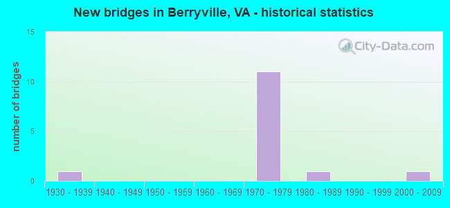
- New bridges - historical statistics
- 11930-1939
- 111970-1979
- 11980-1989
- 12000-2009
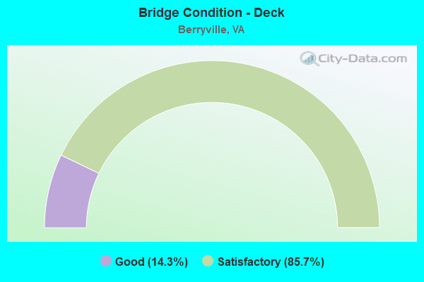
- Bridge Condition - Deck
- 14.3%Good
- 85.7%Satisfactory
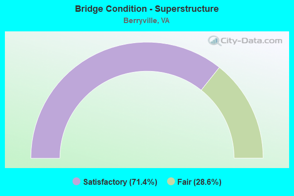
- Bridge Condition - Superstructure
- 71.4%Satisfactory
- 28.6%Fair
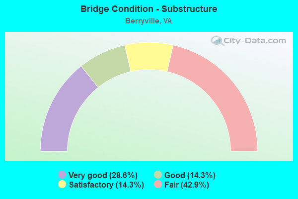
- Bridge Condition - Substructure
- 28.6%Very good
- 14.3%Good
- 14.3%Satisfactory
- 42.9%Fair
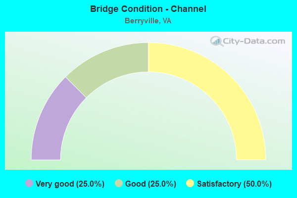
- Bridge Condition - Channel
- 25.0%Very good
- 25.0%Good
- 50.0%Satisfactory
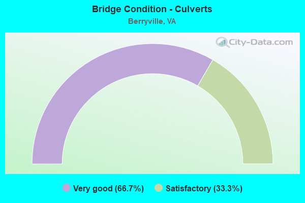
- Bridge Condition - Culverts
- 66.7%Very good
- 33.3%Satisfactory
Find on map >> Show street view
Structure Number: 5362, Location: 0.35 TO 608S- 0.20 TO608N (Lat: 39.142161, Lng: -77.946625), Route carried "on" structure: State highway 7, Year Built: 1973, Status: Open, Structure Length: 0.79m (2.59ft), Average Daily Traffic: 25,538 (year 2020), Truck Traffic: 3%, Average Future Daily Traffic: 33,247 (year 2040), Design Load: HS 20, Features Intersected: BUCK MARSH RUN, Facility Carried by Structure: HARRY BYRD HWY
Minimum Vertical Clearance: 30+ m (98+ ft), Kilometerpoint: 21.120, Lanes on structure: 4, Base Highway Network: Yes, Owner: State Highway Agency, Approaching Roadway Width: 7.9m (25.9ft), Skew: 1 degrees, Material/Design: Concrete, Design/Construction: Culvert, Number Of Spans In Main Unit: 3, Length of Maximum Span: 2.4m (7.9ft)
Condition: Channel: Satisfactory, Culverts: Very good, Operating Rating: 89.8 metric tons, Method Used To Determine Operating Rating: Load Factor (LF), Inventory Rating: 88.9 metric tons, Method Used To Determine Inventory Rating: Load Factor (LF), Structural Evaluation: Equal to present desirable criteria, Waterway Adequacy: Equal to present minimum criteria, Approach Roadway Alignment: Equal to present desirable criteria, Designated Inspection Frequency: Every 24 months, Inspection Date: June 2020
Find on map >> Show street view
Structure Number: 5368, Location: 1.60 TO F729 - 1.55 7BUS (Lat: 39.161286, Lng: -77.977372), Route carried "on" structure: Bypass State highway 7, Year Built: 1975, Status: Open, Structure Length: 5.49m (18.01ft), Average Daily Traffic: 9,773 (year 2020), Truck Traffic: 6%, Average Future Daily Traffic: 13,684 (year 2040), Design Load: HS 20+Mod, Features Intersected: ROUTE 340, Facility Carried by Structure: HARRY BYRD HWY-EBL
Minimum Vertical Clearance: 30+ m (98+ ft), Kilometerpoint: 17.467, Lanes on structure: 2, Lanes under structure: 4, Base Highway Network: Yes, Owner: State Highway Agency, Approaching Roadway Width: 7.3m (24.0ft), Material/Design: Steel, Design/Construction: Stringer/Multi-beam, Number Of Spans In Main Unit: 2, Length of Maximum Span: 27.4m (89.9ft), Curb-To-Curb Width: 11.0m (36.1ft), Out-to-Out Width: 12.2m (40.0ft)
Condition: Deck: Satisfactory, Superstructure: Satisfactory, Substructure: Satisfactory, Operating Rating: 65.3 metric tons, Method Used To Determine Operating Rating: Load and Resistance Factor (LRFR), Inventory Rating: 49.9 metric tons, Method Used To Determine Inventory Rating: Load and Resistance Factor (LRFR), Structural Evaluation: Equal to present minimum criteria, Deck Geometry: Equal to present minimum criteria, Underclear: Equal to present minimum criteria, Approach Roadway Alignment: Equal to present desirable criteria, Designated Inspection Frequency: Every 24 months, Inspection Date: September 2020, Deck Structure Type: Concrete Cast-file-Place, Wearing Surface/Protective System: Wearing Surface: Epoxy Overlay
Find on map >> Show street view
Structure Number: 5372, Location: 0.65 TO 340 -0.90 TO 7BUS (Lat: 39.157150, Lng: -77.966414), Route carried "on" structure: Bypass State highway 7, Year Built: 1975, Status: Open, Structure Length: 3.47m (11.38ft), Average Daily Traffic: 9,773 (year 2020), Truck Traffic: 6%, Average Future Daily Traffic: 13,684 (year 2040), Design Load: HS 20+Mod, Features Intersected: ROUTE 615, Facility Carried by Structure: HARRY BYRD HWY-EBL
Minimum Vertical Clearance: 30+ m (98+ ft), Kilometerpoint: 18.518, Lanes on structure: 2, Lanes under structure: 2, Base Highway Network: Yes, Owner: State Highway Agency, Approaching Roadway Width: 7.3m (24.0ft), Material/Design: Steel, Design/Construction: Stringer/Multi-beam, Number Of Spans In Main Unit: 3, Length of Maximum Span: 15.2m (49.9ft), Curb-To-Curb Width: 11.0m (36.1ft), Out-to-Out Width: 12.2m (40.0ft)
Condition: Deck: Satisfactory, Superstructure: Satisfactory, Substructure: Very good, Operating Rating: 68.0 metric tons, Method Used To Determine Operating Rating: Load and Resistance Factor (LRFR), Inventory Rating: 51.7 metric tons, Method Used To Determine Inventory Rating: Load and Resistance Factor (LRFR), Structural Evaluation: Equal to present minimum criteria, Deck Geometry: Equal to present minimum criteria, Underclear: Meets minimum limits, Approach Roadway Alignment: Better than present minimum criteria, Designated Inspection Frequency: Every 24 months, Inspection Date: September 2020, Deck Structure Type: Concrete Cast-file-Place, Wearing Surface/Protective System: Wearing Surface: Epoxy Overlay
Find on map >> Show street view
Structure Number: 5374, Location: 0.65 TO 340 -0.90 TO 7BUS (Lat: 39.157300, Lng: -77.966297), Route carried "on" structure: Bypass State highway 7, Year Built: 1975, Status: Open, Structure Length: 3.47m (11.38ft), Average Daily Traffic: 9,773 (year 2020), Truck Traffic: 6%, Average Future Daily Traffic: 13,684 (year 2040), Design Load: HS 20+Mod, Features Intersected: ROUTE 615, Facility Carried by Structure: HARRY BYRD HWY-WBL
Minimum Vertical Clearance: 30+ m (98+ ft), Kilometerpoint: 18.518, Lanes on structure: 2, Lanes under structure: 2, Base Highway Network: Yes, Owner: State Highway Agency, Approaching Roadway Width: 7.3m (24.0ft), Material/Design: Steel, Design/Construction: Stringer/Multi-beam, Number Of Spans In Main Unit: 3, Length of Maximum Span: 15.2m (49.9ft), Curb-To-Curb Width: 11.0m (36.1ft), Out-to-Out Width: 12.2m (40.0ft)
Condition: Deck: Good, Superstructure: Satisfactory, Substructure: Very good, Operating Rating: 68.0 metric tons, Method Used To Determine Operating Rating: Load and Resistance Factor (LRFR), Inventory Rating: 51.7 metric tons, Method Used To Determine Inventory Rating: Load and Resistance Factor (LRFR), Structural Evaluation: Equal to present minimum criteria, Deck Geometry: Equal to present minimum criteria, Underclear: Meets minimum limits, Approach Roadway Alignment: Better than present minimum criteria, Designated Inspection Frequency: Every 24 months, Inspection Date: September 2020, Deck Structure Type: Concrete Cast-file-Place, Wearing Surface/Protective System: Wearing Surface: Epoxy Overlay
Find on map >> Show street view
Structure Number: 5376, Location: 0.80 TO 340 -0.75 TO 7BUS (Lat: 39.155744, Lng: -77.964453), Route carried "on" structure: Bypass State highway 7, Year Built: 1975, Status: Open, Structure Length: 4.63m (15.19ft), Average Daily Traffic: 9,773 (year 2020), Truck Traffic: 6%, Average Future Daily Traffic: 13,684 (year 2040), Design Load: HS 20+Mod, Features Intersected: NS RAILWAY, Facility Carried by Structure: HARRY BYRD HWY-EBL
Minimum Vertical Clearance: 30+ m (98+ ft), Kilometerpoint: 18.764, Lanes on structure: 2, Base Highway Network: Yes, Owner: State Highway Agency, Approaching Roadway Width: 7.3m (24.0ft), Material/Design: Steel, Design/Construction: Stringer/Multi-beam, Number Of Spans In Main Unit: 3, Length of Maximum Span: 15.8m (51.8ft), Curb-To-Curb Width: 11.0m (36.1ft), Out-to-Out Width: 12.2m (40.0ft)
Condition: Deck: Satisfactory, Superstructure: Satisfactory, Substructure: Fair, Operating Rating: 68.0 metric tons, Method Used To Determine Operating Rating: Load and Resistance Factor (LRFR), Inventory Rating: 52.6 metric tons, Method Used To Determine Inventory Rating: Load and Resistance Factor (LRFR), Structural Evaluation: Somewhat better than minimum adequacy, Deck Geometry: Equal to present minimum criteria, Underclear: Meets minimum limits, Approach Roadway Alignment: Better than present minimum criteria, Designated Inspection Frequency: Every 24 months, Inspection Date: September 2020, Deck Structure Type: Concrete Cast-file-Place, Wearing Surface/Protective System: Deck Protection: Other
Find on map >> Show street view
Structure Number: 5377, Location: 0.80 TO 340 -0.75 TO 7BUS (Lat: 39.155856, Lng: -77.964283), Route carried "on" structure: Bypass State highway 7, Year Built: 1975, Status: Open, Structure Length: 4.63m (15.19ft), Average Daily Traffic: 9,773 (year 2020), Truck Traffic: 6%, Average Future Daily Traffic: 13,684 (year 2040), Design Load: HS 20+Mod, Features Intersected: NS RAILWAY, Facility Carried by Structure: HARRY BYRD HWY-WBL
Minimum Vertical Clearance: 30+ m (98+ ft), Kilometerpoint: 18.764, Lanes on structure: 2, Base Highway Network: Yes, Owner: State Highway Agency, Approaching Roadway Width: 7.3m (24.0ft), Material/Design: Steel, Design/Construction: Stringer/Multi-beam, Number Of Spans In Main Unit: 3, Length of Maximum Span: 15.8m (51.8ft), Curb-To-Curb Width: 11.0m (36.1ft), Out-to-Out Width: 12.2m (40.0ft)
Condition: Deck: Satisfactory, Superstructure: Satisfactory, Substructure: Fair, Operating Rating: 68.0 metric tons, Method Used To Determine Operating Rating: Load and Resistance Factor (LRFR), Inventory Rating: 52.6 metric tons, Method Used To Determine Inventory Rating: Load and Resistance Factor (LRFR), Structural Evaluation: Somewhat better than minimum adequacy, Deck Geometry: Equal to present minimum criteria, Underclear: Meets minimum limits, Approach Roadway Alignment: Better than present minimum criteria, Designated Inspection Frequency: Every 24 months, Inspection Date: September 2020, Deck Structure Type: Concrete Cast-file-Place, Wearing Surface/Protective System: Deck Protection: Other
Find on map >> Show street view
Structure Number: 5397, Location: 0.08 TO 623S-0.08 TO 623N (Lat: 39.187547, Lng: -77.931317), Route carried "on" structure: US 340, Year Built: 1936, Year Reconstructed: 1987, Status: Open, Structure Length: 4.57m (14.99ft), Average Daily Traffic: 6,167 (year 2020), Truck Traffic: 11%, Average Future Daily Traffic: 8,634 (year 2040), Design Load: HS 20+Mod, Features Intersected: NS RAILWAY, Facility Carried by Structure: LORD FAIRFAX HWY-S
Minimum Vertical Clearance: 30+ m (98+ ft), Kilometerpoint: 195.175, Lanes on structure: 2, Base Highway Network: Yes, Owner: State Highway Agency, Approaching Roadway Width: 6.7m (22.0ft), Skew: 2 degrees, Material/Design: Concrete, Design/Construction: Tee Beam, Number Of Spans In Main Unit: 3, Length of Maximum Span: 16.8m (55.1ft), Curb or Sidewalk Widths: Left: 0.2m (0.7ft), Right: 0.2m (0.7ft), Curb-To-Curb Width: 7.3m (24.0ft), Out-to-Out Width: 8.1m (26.6ft)
Condition: Deck: Satisfactory, Superstructure: Fair, Substructure: Fair, Operating Rating: 42.6 metric tons, Method Used To Determine Operating Rating: Load and Resistance Factor (LRFR), Inventory Rating: 32.7 metric tons, Method Used To Determine Inventory Rating: Load and Resistance Factor (LRFR), Structural Evaluation: Somewhat better than minimum adequacy, Deck Geometry: High priority of replacement, Underclear: Equal to present minimum criteria, Approach Roadway Alignment: Equal to present minimum criteria, Length Of Structure Improvement: 4.57m (14.99ft), Designated Inspection Frequency: Every 24 months, Inspection Date: November 2021, Bridge Improvement Cost: $189,000, Roadway Improvement Cost: $19,000, Total Project Cost: $209,000, Deck Structure Type: Concrete Cast-file-Place, Wearing Surface/Protective System: Wearing Surface: Latex Concrete
Find on map >> Show street view
Structure Number: 5399, Location: 0.80 TO 641 - 0.00 TO 610 (Lat: 39.185636, Lng: -77.939847), Route carried "on" structure: US 340, Year Built: 1980, Status: Open, Structure Length: 1.43m (4.69ft), Average Daily Traffic: 12,334 (year 2020), Truck Traffic: 11%, Average Future Daily Traffic: 17,268 (year 2040), Design Load: HS 20+Mod, Features Intersected: LONG MARSH RUN, Facility Carried by Structure: LORD FAIRFAX HWY
Minimum Vertical Clearance: 30+ m (98+ ft), Kilometerpoint: 194.354, Lanes on structure: 4, Base Highway Network: Yes, Owner: State Highway Agency, Approaching Roadway Width: 14.6m (47.9ft), Skew: 3 degrees, Material/Design: Concrete, Design/Construction: Culvert, Number Of Spans In Main Unit: 4, Length of Maximum Span: 2.7m (8.9ft)
Condition: Channel: Satisfactory, Culverts: Satisfactory, Operating Rating: 89.8 metric tons, Method Used To Determine Operating Rating: Load Factor (LF), Inventory Rating: 88.0 metric tons, Method Used To Determine Inventory Rating: Load Factor (LF), Structural Evaluation: Equal to present minimum criteria, Waterway Adequacy: Equal to present minimum criteria, Approach Roadway Alignment: Better than present minimum criteria, Designated Inspection Frequency: Every 24 months, Inspection Date: Febuary 2021
Find on map >> Show street view
Structure Number: 5429, Location: 0.40 TO 613 - 0.50 TO 608 (Lat: 39.102014, Lng: -77.965233), Route carried "on" structure: County highway 621, Year Built: 1976, Status: Open, Structure Length: 1.55m (5.09ft), Average Daily Traffic: 200 (year 2018), Average Future Daily Traffic: 229 (year 2040), Design Load: HS 20+Mod, Features Intersected: CRAIG RUN, Facility Carried by Structure: LOCKES MILL RD
Minimum Vertical Clearance: 30+ m (98+ ft), Kilometerpoint: 9.493, Lanes on structure: 2, Owner: State Highway Agency, Approaching Roadway Width: 3.7m (12.1ft), Material/Design: Steel, Design/Construction: Stringer/Multi-beam, Number Of Spans In Main Unit: 1, Length of Maximum Span: 14.6m (47.9ft), Curb or Sidewalk Widths: Left: 0.2m (0.7ft), Right: 0.2m (0.7ft), Curb-To-Curb Width: 7.3m (24.0ft), Out-to-Out Width: 7.7m (25.3ft)
Condition: Deck: Satisfactory, Superstructure: Fair, Substructure: Good, Channel: Very good, Operating Rating: 44.5 metric tons, Method Used To Determine Operating Rating: Load and Resistance Factor (LRFR), Inventory Rating: 34.5 metric tons, Method Used To Determine Inventory Rating: Load and Resistance Factor (LRFR), Structural Evaluation: Somewhat better than minimum adequacy, Deck Geometry: Somewhat better than minimum adequacy, Waterway Adequacy: Meets minimum limits, Approach Roadway Alignment: Better than present minimum criteria, Length Of Structure Improvement: 1.55m (5.09ft), Designated Inspection Frequency: Every 24 months, Inspection Date: June 2020, Bridge Improvement Cost: $45,000, Roadway Improvement Cost: $8,000, Total Project Cost: $54,000, Deck Structure Type: Wood or Timber, Wearing Surface/Protective System: Wearing Surface: Bituminous
Find on map >> Show street view
Structure Number: 27644, Location: 0.65 TO 639 - 1.05 TO 654 (Lat: 39.196019, Lng: -77.963228), Route carried "on" structure: County highway 611, Year Built: 2000, Status: Open, Structure Length: 0.79m (2.59ft), Average Daily Traffic: 1,949 (year 2020), Truck Traffic: 1%, Average Future Daily Traffic: 2,729 (year 2040), Design Load: HS 20, Features Intersected: LONG MARSH RUN, Facility Carried by Structure: SUMMIT POINT RD
Minimum Vertical Clearance: 30+ m (98+ ft), Kilometerpoint: 2.285, Lanes on structure: 2, Owner: State Highway Agency, Approaching Roadway Width: 6.1m (20.0ft), Material/Design: Concrete, Design/Construction: Culvert, Number Of Spans In Main Unit: 2, Length of Maximum Span: 3.7m (12.1ft), Curb-To-Curb Width: 6.7m (22.0ft), Out-to-Out Width: 10.4m (34.1ft)
Condition: Channel: Good, Culverts: Very good, Operating Rating: 44.5 metric tons, Method Used To Determine Operating Rating: Field evaluation and documented engineering judgment, Inventory Rating: 32.7 metric tons, Method Used To Determine Inventory Rating: Field evaluation and documented engineering judgment, Structural Evaluation: Equal to present desirable criteria, Deck Geometry: High priority of corrective action, Waterway Adequacy: Somewhat better than minimum adequacy, Approach Roadway Alignment: Better than present minimum criteria, Length Of Structure Improvement: 0.79m (2.59ft), Designated Inspection Frequency: Every 24 months, Inspection Date: June 2021, Bridge Improvement Cost: $35,000, Roadway Improvement Cost: $15,000, Total Project Cost: $51,000
Find on map >> Show street view
Structure Number: 5368, Location: 1.60 TO F729 - 1.55 7BUS (Lat: 39.161286, Lng: -77.977372), Route carried "under" structure: US 340, Year Built: 1975, Structure Length: 0. m, Average Daily Traffic: 13,818 (year 2008), Truck Traffic: 13%, Features Intersected: ROUTE 340, Facility Carried by Structure: HARRY BYRD HWY-EBL
Minimum Vertical Clearance: 5.59m (18.34ft), Kilometerpoint: 189.733, Lanes on structure: 2, Lanes under structure: 4, Material/Design: Steel, Design/Construction: Stringer/Multi-beam, Length of Maximum Span: 27.4m (89.9ft)
Find on map >> Show street view
Structure Number: 537, Location: 1.60 TO F729 - 1.55 7BUS (Lat: 39.161450, Lng: -77.977272), Route carried "under" structure: US 340, Year Built: 1975, Structure Length: 0. m, Average Daily Traffic: 13,818 (year 2008), Truck Traffic: 13%, Features Intersected: ROUTE 340, Facility Carried by Structure: HARRY BYRD HWY-WBL
Minimum Vertical Clearance: 5.61m (18.41ft), Kilometerpoint: 189.749, Lanes on structure: 2, Lanes under structure: 4, Material/Design: Steel, Design/Construction: Stringer/Multi-beam, Length of Maximum Span: 27.4m (89.9ft)
Find on map >> Show street view
Structure Number: 5372, Location: 0.65 TO 340 -0.90 TO 7BUS (Lat: 39.157150, Lng: -77.966414), Route carried "under" structure: County highway 615, Year Built: 1975, Structure Length: 0. m, Average Daily Traffic: 323 (year 2003), Features Intersected: ROUTE 615, Facility Carried by Structure: HARRY BYRD HWY-EBL
Minimum Vertical Clearance: 5.36m (17.59ft), Kilometerpoint: 2.076, Lanes on structure: 2, Lanes under structure: 2, Material/Design: Steel, Design/Construction: Stringer/Multi-beam, Length of Maximum Span: 15.2m (49.9ft)
Find on map >> Show street view
Structure Number: 5374, Location: 0.65 TO 340 -0.90 TO 7BUS (Lat: 39.157300, Lng: -77.966297), Route carried "under" structure: County highway 615, Year Built: 1975, Structure Length: 0. m, Average Daily Traffic: 323 (year 2003), Features Intersected: ROUTE 615, Facility Carried by Structure: HARRY BYRD HWY-WBL
Minimum Vertical Clearance: 5.46m (17.91ft), Kilometerpoint: 2.108, Lanes on structure: 2, Lanes under structure: 2, Material/Design: Steel, Design/Construction: Stringer/Multi-beam, Length of Maximum Span: 15.2m (49.9ft)