Bridge Statistics for Biddeford, Maine (ME)
Condition, Traffic, Stress, Structural Evaluation, Project Costs
- National Bridge Inventory (NBI) Statistics
- 19Number of bridges
- 203ft / 61.9mTotal length
- 258,745Total average daily traffic
- 17,215Total average daily truck traffic
- National Bridge Inventory (NBI) Registered Bridges for Biddeford
- No street view available for this location
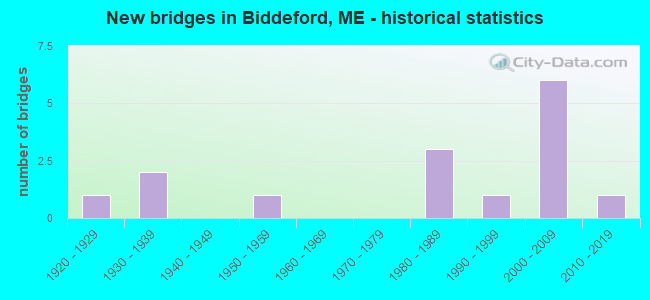
- New bridges - historical statistics
- 11920-1929
- 21930-1939
- 11950-1959
- 31980-1989
- 11990-1999
- 62000-2009
- 12010-2019
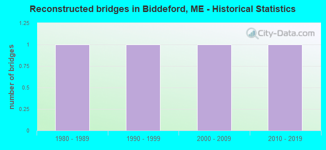
- Reconstructed bridges - Historical Statistics
- 11980-1989
- 11990-1999
- 12000-2009
- 12010-2019
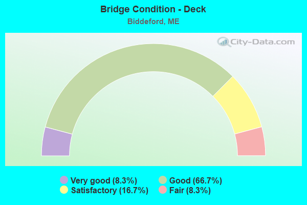
- Bridge Condition - Deck
- 8.3%Very good
- 66.7%Good
- 16.7%Satisfactory
- 8.3%Fair
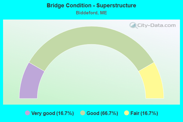
- Bridge Condition - Superstructure
- 16.7%Very good
- 66.7%Good
- 16.7%Fair
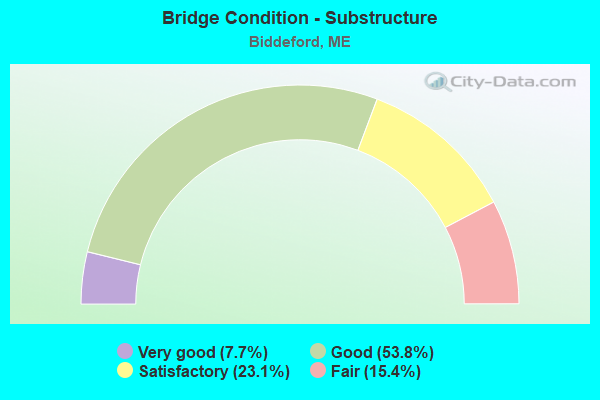
- Bridge Condition - Substructure
- 7.7%Very good
- 53.8%Good
- 23.1%Satisfactory
- 15.4%Fair

- Bridge Condition - Channel
- 50.0%Very good
- 37.5%Good
- 12.5%Fair
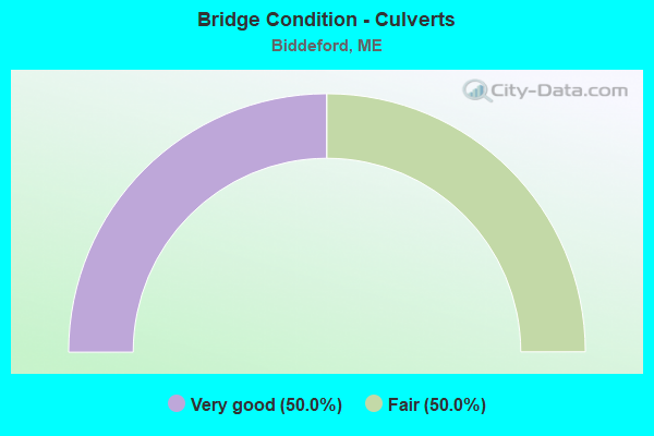
- Bridge Condition - Culverts
- 50.0%Very good
- 50.0%Fair
Find on map >> Show street view
Structure Number: 1301, Location: 0.2 MI N KINGS HWAY GRB (Lat: 43.403311, Lng: -70.404089), Route carried "on" structure: City street , Year Built: 2000, Status: Open, Structure Length: 0.91m (2.99ft), Average Daily Traffic: 761 (year 2016), Truck Traffic: 5%, Average Future Daily Traffic: 1,218 (year 2036), Design Load: HS 25 or greater, Features Intersected: PERKINS BROOK, Facility Carried by Structure: KINGS HIGHWAY G R
Minimum Vertical Clearance: 30+ m (98+ ft), Kilometerpoint: 0.016, Lanes on structure: 2, Owner: Town or Township Highway Agency, Approaching Roadway Width: 7.3m (24.0ft), Material/Design: Prestressed concrete, Design/Construction: Slab, Number Of Spans In Main Unit: 1, Length of Maximum Span: 7.9m (25.9ft), Curb or Sidewalk Widths: Left: 1.5m (4.9ft), Right: 0.3m (1.0ft), Curb-To-Curb Width: 6.1m (20.0ft), Out-to-Out Width: 7.9m (25.9ft)
Condition: Deck: Very good, Superstructure: Very good, Substructure: Good, Channel: Very good, Operating Rating: 52.8 metric tons, Method Used To Determine Operating Rating: Load and Resistance Factor Rating (LRFR) rating reported by rating factor(RF) method using HL-93 loadings, Inventory Rating: 40.8 metric tons, Method Used To Determine Inventory Rating: Load and Resistance Factor Rating (LRFR) rating reported by rating factor(RF) method using HL-93 loadings, Structural Evaluation: Better than present minimum criteria, Deck Geometry: High priority of corrective action, Waterway Adequacy: Better than present minimum criteria, Approach Roadway Alignment: Equal to present minimum criteria, Designated Inspection Frequency: Every 24 months, Inspection Date: July 2020, Deck Structure Type: Concrete Precast Panels, Wearing Surface/Protective System: Wearing Surface: Bituminous, Membrane: Preformed Fabric
Find on map >> Show street view
Structure Number: 1336, Location: 0.358 mi W of Biddo Conn (Lat: 43.477081, Lng: -70.502750), Route carried "on" structure: State highway 111, Year Built: 1994, Status: Open, Structure Length: 8.22m (26.97ft), Average Daily Traffic: 27,445 (year 2016), Truck Traffic: 5%, Average Future Daily Traffic: 38,423 (year 2036), Design Load: HL 93, Features Intersected: I-95
Minimum Vertical Clearance: 30+ m (98+ ft), Kilometerpoint: 4.587, Lanes on structure: 4, Lanes under structure: 6, Base Highway Network: Yes, Owner: State Toll Authority, Approaching Roadway Width: 15.9m (52.2ft), Skew: 4 degrees, Material/Design: Steel continuous, Design/Construction: Stringer/Multi-beam, Number Of Spans In Main Unit: 2, Length of Maximum Span: 41.6m (136.5ft), Curb-To-Curb Width: 15.9m (52.2ft), Out-to-Out Width: 16.9m (55.4ft)
Condition: Deck: Good, Superstructure: Good, Substructure: Satisfactory, Operating Rating: 42.1 metric tons, Method Used To Determine Operating Rating: Load and Resistance Factor Rating (LRFR) rating reported by rating factor(RF) method using HL-93 loadings, Inventory Rating: 32.4 metric tons, Method Used To Determine Inventory Rating: Load and Resistance Factor Rating (LRFR) rating reported by rating factor(RF) method using HL-93 loadings, Structural Evaluation: Equal to present minimum criteria, Deck Geometry: Meets minimum limits, Underclear: Equal to present minimum criteria, Approach Roadway Alignment: Equal to present desirable criteria, Designated Inspection Frequency: Every 24 months, Inspection Date: April 2021, Deck Structure Type: Concrete Cast-file-Place, Wearing Surface/Protective System: Wearing Surface: Bituminous, Membrane: Preformed Fabric, Deck Protection: Epoxy Coated Reinforcing
Find on map >> Show street view
Structure Number: 1338, Location: 0.238 mi NW of SR 111 (Lat: 43.480161, Lng: -70.499889), Route carried "on" structure: Ramp Other road , Year Built: 2003, Year Reconstructed: 2019, Status: Open, Structure Length: 7.86m (25.79ft), Average Daily Traffic: 13,170 (year 2016), Truck Traffic: 5%, Average Future Daily Traffic: 18,438 (year 2036), Design Load: HL 93, Features Intersected: I-95, Facility Carried by Structure: BIDDEFORD INTER.
Minimum Vertical Clearance: 30+ m (98+ ft), Kilometerpoint: 0.209, Lanes on structure: 2, Lanes under structure: 7, Toll: On Interstate toll segment, Owner: State Toll Authority, Approaching Roadway Width: 14.6m (47.9ft), Skew: 30 degrees, Material/Design: Steel continuous, Design/Construction: Stringer/Multi-beam, Number Of Spans In Main Unit: 2, Length of Maximum Span: 39.3m (128.9ft), Curb or Sidewalk Widths: Left: 0.5m (1.6ft), Right: 0.5m (1.6ft), Curb-To-Curb Width: 14.6m (47.9ft), Out-to-Out Width: 16.2m (53.1ft)
Condition: Deck: Good, Superstructure: Good, Substructure: Good, Operating Rating: 50.5 metric tons, Method Used To Determine Operating Rating: Load and Resistance Factor Rating (LRFR) rating reported by rating factor(RF) method using HL-93 loadings, Inventory Rating: 38.9 metric tons, Method Used To Determine Inventory Rating: Load and Resistance Factor Rating (LRFR) rating reported by rating factor(RF) method using HL-93 loadings, Structural Evaluation: Better than present minimum criteria, Deck Geometry: Superior to present desirable criteria, Underclear: Equal to present minimum criteria, Approach Roadway Alignment: Equal to present desirable criteria, Designated Inspection Frequency: Every 24 months, Inspection Date: April 2021, Deck Structure Type: Concrete Cast-file-Place, Wearing Surface/Protective System: Wearing Surface: Bituminous, Membrane: Preformed Fabric, Deck Protection: Epoxy Coated Reinforcing
Find on map >> Show street view
Structure Number: 134, Location: 0.138 mi W of Cathedral (Lat: 43.495961, Lng: -70.490150), Route carried "on" structure: County highway , Year Built: 2001, Status: Open, Structure Length: 5.83m (19.13ft), Average Daily Traffic: 4,469 (year 2016), Truck Traffic: 5%, Average Future Daily Traffic: 6,257 (year 2036), Design Load: HL 93, Features Intersected: I-95, Facility Carried by Structure: SOUTH ST
Minimum Vertical Clearance: 30+ m (98+ ft), Kilometerpoint: 2.832, Lanes on structure: 2, Lanes under structure: 6, Owner: State Toll Authority, Approaching Roadway Width: 11.0m (36.1ft), Skew: 1 degrees, Material/Design: Steel continuous, Design/Construction: Stringer/Multi-beam, Number Of Spans In Main Unit: 2, Length of Maximum Span: 29.1m (95.5ft), Curb-To-Curb Width: 11.0m (36.1ft), Out-to-Out Width: 11.9m (39.0ft)
Condition: Deck: Good, Superstructure: Good, Substructure: Good, Operating Rating: 40.8 metric tons, Method Used To Determine Operating Rating: Load and Resistance Factor Rating (LRFR) rating reported by rating factor(RF) method using HL-93 loadings, Inventory Rating: 31.4 metric tons, Method Used To Determine Inventory Rating: Load and Resistance Factor Rating (LRFR) rating reported by rating factor(RF) method using HL-93 loadings, Structural Evaluation: Better than present minimum criteria, Deck Geometry: Somewhat better than minimum adequacy, Underclear: Equal to present minimum criteria, Approach Roadway Alignment: Equal to present minimum criteria, Designated Inspection Frequency: Every 24 months, Inspection Date: April 2021, Deck Structure Type: Concrete Cast-file-Place, Wearing Surface/Protective System: Wearing Surface: Bituminous, Membrane: Preformed Fabric, Deck Protection: Epoxy Coated Reinforcing
Find on map >> Show street view
Structure Number: 1351, Location: .1 M IS TL @ HOOPER ST (Lat: 43.496661, Lng: -70.456400), Year Built: 1929, Status: Open, Structure Length: 4.24m (13.91ft), Average Daily Traffic: 18,964 (year 2018), Truck Traffic: 5%, Average Future Daily Traffic: 30,184 (year 2034), Design Load: Railroad, Features Intersected: US ROUTE 1 ELM STREET
Lanes under structure: 2, Owner: Railroad, Skew: 3 degrees, Material/Design: Steel, Design/Construction: Truss - Thru, Number Of Spans In Main Unit: 1, Length of Maximum Span: 41.1m (134.8ft), Out-to-Out Width: 8.5m (27.9ft)
Condition: Substructure: Fair, Underclear: High priority of corrective action, Designated Inspection Frequency: Every 24 months, Inspection Date: June 2021
Find on map >> Show street view
Structure Number: 2265, Location: BIDDEFORD-SACO T L (Lat: 43.498750, Lng: -70.451400), Route carried "on" structure: State highway 1, Year Built: 1933, Year Reconstructed: 1993, Status: Open, Structure Length: 9.70m (31.82ft), Average Daily Traffic: 14,908 (year 2016), Truck Traffic: 5%, Average Future Daily Traffic: 20,871 (year 2036), Design Load: HS 20, Features Intersected: SACO RIVER (N OF E CHAN), Facility Carried by Structure: ELM ST
Minimum Vertical Clearance: 30+ m (98+ ft), Kilometerpoint: 55.490, Lanes on structure: 2, Base Highway Network: Yes, Owner: State Highway Agency, Approaching Roadway Width: 11.0m (36.1ft), Material/Design: Steel, Design/Construction: Stringer/Multi-beam, Number Of Spans In Main Unit: 5, Length of Maximum Span: 19.2m (63.0ft), Curb or Sidewalk Widths: Left: 1.5m (4.9ft), Right: 0.2m (0.7ft), Curb-To-Curb Width: 10.9m (35.8ft), Out-to-Out Width: 13.2m (43.3ft)
Condition: Deck: Satisfactory, Superstructure: Fair, Substructure: Fair, Channel: Good, Operating Rating: 46.7 metric tons, Method Used To Determine Operating Rating: Load and Resistance Factor Rating (LRFR) rating reported by rating factor(RF) method using HL-93 loadings, Inventory Rating: 36.0 metric tons, Method Used To Determine Inventory Rating: Load and Resistance Factor Rating (LRFR) rating reported by rating factor(RF) method using HL-93 loadings, Structural Evaluation: Somewhat better than minimum adequacy, Deck Geometry: Meets minimum limits, Waterway Adequacy: Superior to present desirable criteria, Approach Roadway Alignment: Better than present minimum criteria, Designated Inspection Frequency: Every 24 months, Underwater Inspection Frequency: Every 60 months, Inspection Date: April 2021, Underwater Inspection Date: November 2021, Deck Structure Type: Concrete Cast-file-Place, Wearing Surface/Protective System: Wearing Surface: Bituminous
Find on map >> Show street view
Structure Number: 308, Location: 0.2 MI W'LY OF SACO T.L. (Lat: 43.497681, Lng: -70.455111), Route carried "on" structure: State highway 1, Year Built: 1985, Year Reconstructed: 2014, Status: Open, Structure Length: 5.15m (16.90ft), Average Daily Traffic: 19,478 (year 2016), Truck Traffic: 5%, Average Future Daily Traffic: 27,269 (year 2036), Design Load: HS 25 or greater, Features Intersected: SACO RIVER (W OR S CHAN), Facility Carried by Structure: ELM ST
Minimum Vertical Clearance: 30+ m (98+ ft), Kilometerpoint: 55.184, Lanes on structure: 2, Base Highway Network: Yes, Owner: State Highway Agency, Approaching Roadway Width: 11.9m (39.0ft), Skew: 2 degrees, Material/Design: Steel continuous, Design/Construction: Stringer/Multi-beam, Number Of Spans In Main Unit: 2, Length of Maximum Span: 24.7m (81.0ft), Curb or Sidewalk Widths: Left: 0.2m (0.7ft), Right: 2.2m (7.2ft), Curb-To-Curb Width: 11.9m (39.0ft), Out-to-Out Width: 15.0m (49.2ft)
Condition: Deck: Good, Superstructure: Good, Substructure: Good, Channel: Good, Operating Rating: 42.4 metric tons, Method Used To Determine Operating Rating: Load and Resistance Factor Rating (LRFR) rating reported by rating factor(RF) method using HL-93 loadings, Inventory Rating: 32.7 metric tons, Method Used To Determine Inventory Rating: Load and Resistance Factor Rating (LRFR) rating reported by rating factor(RF) method using HL-93 loadings, Structural Evaluation: Better than present minimum criteria, Deck Geometry: Somewhat better than minimum adequacy, Waterway Adequacy: Superior to present desirable criteria, Approach Roadway Alignment: Better than present minimum criteria, Designated Inspection Frequency: Every 24 months, Underwater Inspection Frequency: Every 60 months, Inspection Date: October 2020, Underwater Inspection Date: March 2019, Deck Structure Type: Concrete Cast-file-Place, Wearing Surface/Protective System: Wearing Surface: Bituminous, Membrane: Preformed Fabric
Find on map >> Show street view
Structure Number: 3163, Location: 1.0 MO W OF TPKE OVERPASS (Lat: 43.498231, Lng: -70.508919), Route carried "on" structure: County highway , Year Built: 2000, Status: Open, Structure Length: 4.58m (15.03ft), Average Daily Traffic: 3,840 (year 2016), Truck Traffic: 5%, Average Future Daily Traffic: 5,376 (year 2036), Design Load: HS 25 or greater, Features Intersected: SWAN POND BROOK, Facility Carried by Structure: SOUTH ST
Minimum Vertical Clearance: 30+ m (98+ ft), Kilometerpoint: 1.127, Lanes on structure: 2, Owner: State Highway Agency, Approaching Roadway Width: 9.1m (29.9ft), Skew: 3 degrees, Material/Design: Steel, Design/Construction: Stringer/Multi-beam, Number Of Spans In Main Unit: 1, Length of Maximum Span: 45.0m (147.6ft), Curb-To-Curb Width: 9.4m (30.8ft), Out-to-Out Width: 10.6m (34.8ft)
Condition: Deck: Good, Superstructure: Very good, Substructure: Very good, Channel: Very good, Operating Rating: 53.5 metric tons, Method Used To Determine Operating Rating: Load and Resistance Factor Rating (LRFR) rating reported by rating factor(RF) method using HL-93 loadings, Inventory Rating: 41.5 metric tons, Method Used To Determine Inventory Rating: Load and Resistance Factor Rating (LRFR) rating reported by rating factor(RF) method using HL-93 loadings, Structural Evaluation: Equal to present desirable criteria, Deck Geometry: Meets minimum limits, Waterway Adequacy: Equal to present desirable criteria, Approach Roadway Alignment: Equal to present desirable criteria, Designated Inspection Frequency: Every 24 months, Inspection Date: November 2021, Deck Structure Type: Concrete Cast-file-Place, Wearing Surface/Protective System: Wearing Surface: Bituminous, Membrane: Preformed Fabric
Find on map >> Show street view
Structure Number: 3418, Location: 1 MI NW RTE 1 (Lat: 43.496900, Lng: -70.475281), Route carried "on" structure: County highway , Year Built: 1930, Year Reconstructed: 1997, Status: Open, Structure Length: 0.98m (3.22ft), Average Daily Traffic: 2,440 (year 2016), Truck Traffic: 5%, Average Future Daily Traffic: 3,416 (year 2036), Design Load: HS 25 or greater, Features Intersected: THATCHER BROOK, Facility Carried by Structure: MAIN ST
Minimum Vertical Clearance: 30+ m (98+ ft), Kilometerpoint: 1.931, Lanes on structure: 2, Owner: State Highway Agency, Approaching Roadway Width: 9.1m (29.9ft), Material/Design: Wood or Timber, Design/Construction: Stringer/Multi-beam, Number Of Spans In Main Unit: 1, Length of Maximum Span: 8.5m (27.9ft), Curb or Sidewalk Widths: Left: 0.0m, Right: 1.5m (4.9ft), Curb-To-Curb Width: 8.5m (27.9ft), Out-to-Out Width: 10.7m (35.1ft)
Condition: Deck: Good, Superstructure: Good, Substructure: Satisfactory, Channel: Good, Operating Rating: 56.7 metric tons, Method Used To Determine Operating Rating: Load and Resistance Factor Rating (LRFR) rating reported by rating factor(RF) method using HL-93 loadings, Inventory Rating: 43.7 metric tons, Method Used To Determine Inventory Rating: Load and Resistance Factor Rating (LRFR) rating reported by rating factor(RF) method using HL-93 loadings, Structural Evaluation: Equal to present minimum criteria, Deck Geometry: Meets minimum limits, Waterway Adequacy: Equal to present desirable criteria, Approach Roadway Alignment: Equal to present desirable criteria, Designated Inspection Frequency: Every 24 months, Inspection Date: December 2020, Deck Structure Type: Wood or Timber, Wearing Surface/Protective System: Wearing Surface: Bituminous, Membrane: Preformed Fabric, Deck Protection: Other
Find on map >> Show street view
Structure Number: 3423, Location: SACO/BIDDEFORD T L (Lat: 43.493089, Lng: -70.448950), Route carried "on" structure: County highway 9, Year Built: 2004, Status: Open, Structure Length: 6.79m (22.28ft), Average Daily Traffic: 21,430 (year 2016), Truck Traffic: 5%, Average Future Daily Traffic: 30,002 (year 2036), Design Load: HS 25 or greater, Features Intersected: SACO RIVER WEST CHANNEL, Facility Carried by Structure: MAIN ST
Minimum Vertical Clearance: 30+ m (98+ ft), Kilometerpoint: 60.704, Lanes on structure: 3, Owner: State Highway Agency, Approaching Roadway Width: 13.1m (43.0ft), Material/Design: Steel continuous, Design/Construction: Stringer/Multi-beam, Number Of Spans In Main Unit: 2, Length of Maximum Span: 33.1m (108.6ft), Curb or Sidewalk Widths: Left: 2.0m (6.6ft), Right: 0.0m, Curb-To-Curb Width: 11.7m (38.4ft), Out-to-Out Width: 16.0m (52.5ft)
Condition: Deck: Good, Superstructure: Good, Substructure: Good, Channel: Very good, Operating Rating: 61.2 metric tons, Method Used To Determine Operating Rating: Load and Resistance Factor Rating (LRFR) rating reported by rating factor(RF) method using HL-93 loadings, Inventory Rating: 47.3 metric tons, Method Used To Determine Inventory Rating: Load and Resistance Factor Rating (LRFR) rating reported by rating factor(RF) method using HL-93 loadings, Structural Evaluation: Better than present minimum criteria, Deck Geometry: High priority of corrective action, Waterway Adequacy: Superior to present desirable criteria, Approach Roadway Alignment: Equal to present desirable criteria, Designated Inspection Frequency: Every 24 months, Underwater Inspection Frequency: Every 60 months, Inspection Date: April 2021, Underwater Inspection Date: October 2021, Deck Structure Type: Concrete Cast-file-Place, Wearing Surface/Protective System: Wearing Surface: Bituminous, Membrane: Preformed Fabric
Find on map >> Show street view
Structure Number: 3908, Location: .6 MI W US 1 (Lat: 43.480681, Lng: -70.482319), Route carried "on" structure: State highway 111, Year Built: 2004, Status: Open, Structure Length: 2.47m (8.10ft), Average Daily Traffic: 21,790 (year 2016), Truck Traffic: 5%, Average Future Daily Traffic: 30,506 (year 2036), Design Load: HS 25 or greater, Features Intersected: B&M RR, Facility Carried by Structure: ALFRED ST
Minimum Vertical Clearance: 30+ m (98+ ft), Kilometerpoint: 2.816, Lanes on structure: 4, Base Highway Network: Yes, Owner: State Highway Agency, Approaching Roadway Width: 16.5m (54.1ft), Skew: 3 degrees, Material/Design: Prestressed concrete, Design/Construction: Box Beam or Girders - Multiple, Number Of Spans In Main Unit: 1, Length of Maximum Span: 22.9m (75.1ft), Curb or Sidewalk Widths: Left: 1.7m (5.6ft), Right: 0.1m (0.3ft), Curb-To-Curb Width: 16.4m (53.8ft), Out-to-Out Width: 18.9m (62.0ft)
Condition: Deck: Good, Superstructure: Good, Substructure: Good, Operating Rating: 56.4 metric tons, Method Used To Determine Operating Rating: Load and Resistance Factor Rating (LRFR) rating reported by rating factor(RF) method using HL-93 loadings, Inventory Rating: 43.7 metric tons, Method Used To Determine Inventory Rating: Load and Resistance Factor Rating (LRFR) rating reported by rating factor(RF) method using HL-93 loadings, Structural Evaluation: Better than present minimum criteria, Deck Geometry: Meets minimum limits, Approach Roadway Alignment: Equal to present desirable criteria, Designated Inspection Frequency: Every 24 months, Inspection Date: April 2021, Deck Structure Type: Concrete Precast Panels, Wearing Surface/Protective System: Wearing Surface: Bituminous, Membrane: Preformed Fabric
Find on map >> Show street view
Structure Number: 391, Location: 0.6 MI SE OF S JCT RTE 9 (Lat: 43.436761, Lng: -70.369861), Route carried "on" structure: County highway 208, Year Built: 2014, Status: Open, Structure Length: 0.73m (2.40ft), Average Daily Traffic: 1,930 (year 2016), Truck Traffic: 5%, Average Future Daily Traffic: 2,895 (year 2036), Design Load: Greater than HL93, Features Intersected: SNAKE RIVER, Facility Carried by Structure: BRIDGE RD
Minimum Vertical Clearance: 30+ m (98+ ft), Kilometerpoint: 9.704, Lanes on structure: 2, Owner: State Highway Agency, Approaching Roadway Width: 9.8m (32.2ft), Material/Design: Concrete, Design/Construction: Culvert, Number Of Spans In Main Unit: 1, Length of Maximum Span: 6.7m (22.0ft), Curb or Sidewalk Widths: Left: 0.0m, Right: 0.5m (1.6ft), Curb-To-Curb Width: 8.5m (27.9ft), Out-to-Out Width: 8.5m (27.9ft)
Condition: Channel: Very good, Culverts: Very good, Operating Rating: 50.5 metric tons, Method Used To Determine Operating Rating: Load and Resistance Factor Rating (LRFR) rating reported by rating factor(RF) method using HL-93 loadings, Inventory Rating: 45.7 metric tons, Method Used To Determine Inventory Rating: Load and Resistance Factor Rating (LRFR) rating reported by rating factor(RF) method using HL-93 loadings, Structural Evaluation: Equal to present desirable criteria, Deck Geometry: Somewhat better than minimum adequacy, Waterway Adequacy: Better than present minimum criteria, Approach Roadway Alignment: Better than present minimum criteria, Designated Inspection Frequency: Every 24 months, Inspection Date: November 2021
Find on map >> Show street view
Structure Number: 5736, Location: 250 FT NE OF KENNE-PORT (Lat: 43.421069, Lng: -70.407300), Route carried "on" structure: County highway 9, Year Built: 1959, Status: Open, Structure Length: 0.70m (2.30ft), Average Daily Traffic: 2,370 (year 2016), Truck Traffic: 5%, Average Future Daily Traffic: 3,318 (year 2036), Design Load: H 20, Features Intersected: LITTLE RIVER, Facility Carried by Structure: POOL ST
Minimum Vertical Clearance: 30+ m (98+ ft), Kilometerpoint: 47.620, Lanes on structure: 2, Owner: State Highway Agency, Approaching Roadway Width: 11.0m (36.1ft), Skew: 1 degrees, Material/Design: Steel, Design/Construction: Culvert, Number Of Spans In Main Unit: 1, Length of Maximum Span: 7.0m (23.0ft)
Condition: Channel: Fair, Culverts: Fair, Inventory Rating: 97.2 metric tons, Method Used To Determine Inventory Rating: Load and Resistance Factor Rating (LRFR) rating reported by rating factor(RF) method using HL-93 loadings, Structural Evaluation: Somewhat better than minimum adequacy, Waterway Adequacy: Equal to present desirable criteria, Approach Roadway Alignment: Equal to present desirable criteria, Designated Inspection Frequency: Every 24 months, Inspection Date: November 2021
Find on map >> Show street view
Structure Number: 6194, Location: .5 MI W JCT US 1 (Lat: 43.492589, Lng: -70.471100), Route carried "on" structure: County highway , Year Built: 1980, Status: Open, Structure Length: 0.99m (3.25ft), Average Daily Traffic: 6,088 (year 2016), Truck Traffic: 5%, Average Future Daily Traffic: 8,523 (year 2036), Design Load: H 20, Features Intersected: B&MRR SPUR, Facility Carried by Structure: SOUTH ST
Minimum Vertical Clearance: 30+ m (98+ ft), Kilometerpoint: 1.191, Lanes on structure: 2, Owner: Railroad, Maintenance Responsibility: State Highway Agency, Approaching Roadway Width: 11.0m (36.1ft), Skew: 2 degrees, Material/Design: Concrete, Design/Construction: Slab, Number Of Spans In Main Unit: 1, Length of Maximum Span: 8.4m (27.6ft), Curb or Sidewalk Widths: Left: 0.2m (0.7ft), Right: 1.8m (5.9ft), Curb-To-Curb Width: 11.0m (36.1ft), Out-to-Out Width: 13.7m (44.9ft)
Condition: Deck: Fair, Superstructure: Fair, Substructure: Good, Operating Rating: 51.5 metric tons, Method Used To Determine Operating Rating: Load and Resistance Factor Rating (LRFR) rating reported by rating factor(RF) method using HL-93 loadings, Inventory Rating: 39.9 metric tons, Method Used To Determine Inventory Rating: Load and Resistance Factor Rating (LRFR) rating reported by rating factor(RF) method using HL-93 loadings, Structural Evaluation: Somewhat better than minimum adequacy, Deck Geometry: Meets minimum limits, Underclear: High priority of corrective action, Approach Roadway Alignment: Equal to present desirable criteria, Designated Inspection Frequency: Every 24 months, Inspection Date: December 2020, Deck Structure Type: Concrete Cast-file-Place, Wearing Surface/Protective System: Wearing Surface: Monolithic Concrete
Find on map >> Show street view
Structure Number: 6195, Location: .4 MI W JCT US 1 (Lat: 43.492589, Lng: -70.469650), Route carried "on" structure: County highway , Year Built: 1980, Status: Open, Structure Length: 2.74m (8.99ft), Average Daily Traffic: 6,682 (year 2016), Truck Traffic: 5%, Average Future Daily Traffic: 9,355 (year 2036), Design Load: H 20, Features Intersected: B&MRR, Facility Carried by Structure: SOUTH ST
Minimum Vertical Clearance: 30+ m (98+ ft), Kilometerpoint: 1.094, Lanes on structure: 2, Owner: Railroad, Maintenance Responsibility: State Highway Agency, Approaching Roadway Width: 11.0m (36.1ft), Skew: 5 degrees, Material/Design: Steel, Design/Construction: Stringer/Multi-beam, Number Of Spans In Main Unit: 1, Length of Maximum Span: 24.4m (80.1ft), Curb or Sidewalk Widths: Left: 0.5m (1.6ft), Right: 2.2m (7.2ft), Curb-To-Curb Width: 11.0m (36.1ft), Out-to-Out Width: 13.7m (44.9ft)
Condition: Deck: Satisfactory, Superstructure: Good, Substructure: Satisfactory, Operating Rating: 75.2 metric tons, Method Used To Determine Operating Rating: Load and Resistance Factor Rating (LRFR) rating reported by rating factor(RF) method using HL-93 loadings, Inventory Rating: 59.0 metric tons, Method Used To Determine Inventory Rating: Load and Resistance Factor Rating (LRFR) rating reported by rating factor(RF) method using HL-93 loadings, Structural Evaluation: Equal to present minimum criteria, Deck Geometry: Meets minimum limits, Underclear: Meets minimum limits, Approach Roadway Alignment: Equal to present minimum criteria, Designated Inspection Frequency: Every 24 months, Inspection Date: December 2020, Deck Structure Type: Concrete Cast-file-Place, Wearing Surface/Protective System: Wearing Surface: Monolithic Concrete
Find on map >> Show street view
Location: 0.060 mi W of Skillings R (Lat: 43.467667, Lng: -70.515789), Route carried "on" structure: Bypass State highway 52110, Structure Length: 0. m, Average Daily Traffic: 24,670 (year 2014), Truck Traffic: 11%, Features Intersected: OLD ALFRED RD, Facility Carried by Structure: I-95
Minimum Vertical Clearance: 4.47m (14.67ft), Kilometerpoint: 48.007, Lanes on structure: 4, Toll: On Interstate toll segment, Length of Maximum Span: 0.0m
Find on map >> Show street view
Location: 0.358 mi W of Biddo Conn (Lat: 43.470000, Lng: -70.500000), Route carried "on" structure: Bypass State highway 62110, Structure Length: 0. m, Average Daily Traffic: 24,670 (year 2014), Truck Traffic: 11%, Features Intersected: ALFRED RD-RTE 111, Facility Carried by Structure: INT 95 NB
Minimum Vertical Clearance: 4.34m (14.24ft), Kilometerpoint: 49.149, Lanes on structure: 4, Toll: On Interstate toll segment, Length of Maximum Span: 0.0m
Find on map >> Show street view
Location: 0.238 mi NW of SR 111 (Lat: 43.480000, Lng: -70.490000), Route carried "on" structure: Bypass State highway 82110, Structure Length: 0. m, Average Daily Traffic: 22,080 (year 2014), Truck Traffic: 11%, Features Intersected: BIDDEFORD INTER., Facility Carried by Structure: INT 95 NB
Minimum Vertical Clearance: 4.34m (14.24ft), Kilometerpoint: 50.131, Lanes on structure: 5, Toll: On Interstate toll segment, Length of Maximum Span: 0.0m
Find on map >> Show street view
Location: .1 M IS TL @ HOOPER ST (Lat: 43.496656, Lng: -70.456403), Route carried "on" structure: State highway 12310, Structure Length: 0. m, Average Daily Traffic: 21,560 (year 2014), Truck Traffic: 5%, Features Intersected: BOSTON AND MAINE R, Facility Carried by Structure: US ROUTE 1 ELM STR
Minimum Vertical Clearance: 4.44m (14.57ft), Kilometerpoint: 55.007, Lanes on structure: 3, Length of Maximum Span: 0.0m