Bridge Statistics for Bismarck, North Dakota (ND)
Condition, Traffic, Stress, Structural Evaluation, Project Costs
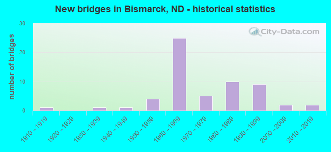
- New bridges - historical statistics
- 11910-1919
- 11930-1939
- 11940-1949
- 41950-1959
- 251960-1969
- 51970-1979
- 101980-1989
- 91990-1999
- 22000-2009
- 22010-2019
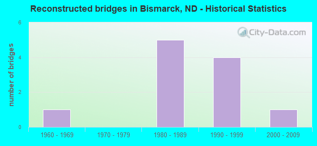
- Reconstructed bridges - Historical Statistics
- 11960-1969
- 01970-1979
- 51980-1989
- 41990-1999
- 12000-2009
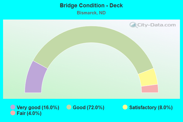
- Bridge Condition - Deck
- 16.0%Very good
- 72.0%Good
- 8.0%Satisfactory
- 4.0%Fair
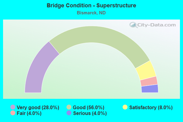
- Bridge Condition - Superstructure
- 28.0%Very good
- 56.0%Good
- 8.0%Satisfactory
- 4.0%Fair
- 4.0%Serious
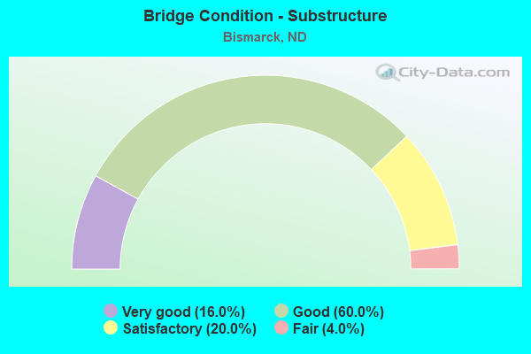
- Bridge Condition - Substructure
- 16.0%Very good
- 60.0%Good
- 20.0%Satisfactory
- 4.0%Fair

- Bridge Condition - Channel
- 15.4%Excellent
- 23.1%Very good
- 34.6%Good
- 15.4%Satisfactory
- 11.5%Fair
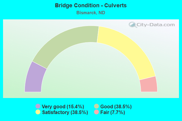
- Bridge Condition - Culverts
- 15.4%Very good
- 38.5%Good
- 38.5%Satisfactory
- 7.7%Fair
Find on map >> Show street view
Structure Number: 810729, Location: 6 NORTH 2 WEST BISMARCK (Lat: 46.915114, Lng: -100.814236), Route carried "on" structure: County highway , Year Built: 1983, Status: Open, Structure Length: 2.16m (7.09ft), Average Daily Traffic: 50 (year 2019), Average Future Daily Traffic: 60 (year 2039), Design Load: H 20, Features Intersected: BURNT CREEK, Facility Carried by Structure: 15TH ST. NW
Minimum Vertical Clearance: 30+ m (98+ ft), Kilometerpoint: 0.000, Lanes on structure: 2, Owner: County Highway Agency, Approaching Roadway Width: 7.3m (24.0ft), Material/Design: Prestressed concrete, Design/Construction: Box Beam or Girders - Multiple, Number Of Spans In Main Unit: 1, Length of Maximum Span: 20.7m (67.9ft), Curb-To-Curb Width: 8.6m (28.2ft), Out-to-Out Width: 9.3m (30.5ft)
Condition: Deck: Very good, Superstructure: Good, Substructure: Good, Channel: Good, Operating Rating: 59.1 metric tons, Method Used To Determine Operating Rating: Load Factor (LF), Inventory Rating: 35.3 metric tons, Method Used To Determine Inventory Rating: Load Factor (LF), Structural Evaluation: Better than present minimum criteria, Deck Geometry: Better than present minimum criteria, Waterway Adequacy: Better than present minimum criteria, Approach Roadway Alignment: Equal to present minimum criteria, Designated Inspection Frequency: Every 24 months, Inspection Date: July 2021, Deck Structure Type: Other, Wearing Surface/Protective System: Wearing Surface: Gravel
Find on map >> Show street view
Structure Number: 8108281, Location: 2 WEST 6 NORTH BISMARCK (Lat: 46.925342, Lng: -100.803072), Route carried "on" structure: County highway , Year Built: 1979, Status: Open, Structure Length: 2.16m (7.09ft), Average Daily Traffic: 40 (year 2019), Average Future Daily Traffic: 60 (year 2039), Design Load: H 20, Features Intersected: BURNT CREEK, Facility Carried by Structure: 110TH AVE. NW
Minimum Vertical Clearance: 30+ m (98+ ft), Kilometerpoint: 0.000, Lanes on structure: 2, Owner: County Highway Agency, Approaching Roadway Width: 8.5m (27.9ft), Material/Design: Prestressed concrete, Design/Construction: Box Beam or Girders - Multiple, Number Of Spans In Main Unit: 1, Length of Maximum Span: 20.7m (67.9ft), Curb-To-Curb Width: 9.1m (29.9ft), Out-to-Out Width: 9.3m (30.5ft)
Condition: Deck: Very good, Superstructure: Very good, Substructure: Good, Channel: Good, Operating Rating: 89.8 metric tons, Method Used To Determine Operating Rating: Allowable Stress (AS), Inventory Rating: 43.5 metric tons, Method Used To Determine Inventory Rating: Allowable Stress (AS), Structural Evaluation: Better than present minimum criteria, Deck Geometry: Better than present minimum criteria, Waterway Adequacy: Better than present minimum criteria, Approach Roadway Alignment: Equal to present minimum criteria, Designated Inspection Frequency: Every 24 months, Inspection Date: July 2021, Deck Structure Type: Other, Wearing Surface/Protective System: Wearing Surface: Gravel
Find on map >> Show street view
Structure Number: 811239, Location: 3 SOUTH 3 EAST BISMARCK (Lat: 46.765664, Lng: -100.722733), Route carried "on" structure: City street 8197, Year Built: 1914, Year Reconstructed: 1974, Status: Open, Structure Length: 2.44m (8.01ft), Average Daily Traffic: 2,900 (year 2019), Truck Traffic: 1%, Average Future Daily Traffic: 3,770 (year 2039), Design Load: H 15, Features Intersected: APPLE CREEK, Facility Carried by Structure: LINCOLN ROAD
Minimum Vertical Clearance: 30+ m (98+ ft), Kilometerpoint: 0.644, Lanes on structure: 2, Owner: County Highway Agency, Approaching Roadway Width: 7.0m (23.0ft), Material/Design: Prestressed concrete, Design/Construction: Box Beam or Girders - Multiple, Number Of Spans In Main Unit: 1, Length of Maximum Span: 22.6m (74.1ft), Curb-To-Curb Width: 8.7m (28.5ft), Out-to-Out Width: 9.3m (30.5ft)
Condition: Deck: Very good, Superstructure: Satisfactory, Substructure: Satisfactory, Channel: Satisfactory, Operating Rating: 68.2 metric tons, Method Used To Determine Operating Rating: Load Factor (LF), Inventory Rating: 40.8 metric tons, Method Used To Determine Inventory Rating: Load Factor (LF), Structural Evaluation: Equal to present minimum criteria, Deck Geometry: Meets minimum limits, Waterway Adequacy: Superior to present desirable criteria, Approach Roadway Alignment: Equal to present desirable criteria, Length Of Structure Improvement: 2.44m (8.01ft), Designated Inspection Frequency: Every 24 months, Inspection Date: November 2020, Bridge Improvement Cost: $61,000, Roadway Improvement Cost: $6,000, Total Project Cost: $92,000
Find on map >> Show street view
Structure Number: 811337, Location: 1 EAST OF YEGEN ROAD (Lat: 46.794561, Lng: -100.716006), Route carried "on" structure: County highway , Year Built: 1990, Status: Open, Structure Length: 0.82m (2.69ft), Average Daily Traffic: 925 (year 2019), Truck Traffic: 8%, Average Future Daily Traffic: 925 (year 2039), Design Load: HS 20, Features Intersected: CREEK, Facility Carried by Structure: COUNTY ROAD
Minimum Vertical Clearance: 30+ m (98+ ft), Kilometerpoint: 0.000, Lanes on structure: 2, Owner: County Highway Agency, Approaching Roadway Width: 13.1m (43.0ft), Material/Design: Concrete, Design/Construction: Culvert, Number Of Spans In Main Unit: 2, Length of Maximum Span: 3.7m (12.1ft)
Condition: Channel: Fair, Culverts: Satisfactory, Operating Rating: 54.0 metric tons, Method Used To Determine Operating Rating: Load Factor (LF), Inventory Rating: 32.4 metric tons, Method Used To Determine Inventory Rating: Load Factor (LF), Structural Evaluation: Equal to present minimum criteria, Waterway Adequacy: Equal to present desirable criteria, Approach Roadway Alignment: Equal to present desirable criteria, Designated Inspection Frequency: Every 24 months, Inspection Date: November 2020
Find on map >> Show street view
Structure Number: 811338, Location: 3 EAST OF BISMARCK (Lat: 46.792525, Lng: -100.689200), Route carried "on" structure: County highway 813, Year Built: 1987, Status: Open, Structure Length: 2.29m (7.51ft), Average Daily Traffic: 850 (year 2019), Truck Traffic: 10%, Average Future Daily Traffic: 1,000 (year 2039), Design Load: HS 20, Features Intersected: APPLE CREEK, Facility Carried by Structure: COUNTY ROAD
Minimum Vertical Clearance: 30+ m (98+ ft), Kilometerpoint: 3.057, Lanes on structure: 2, Owner: County Highway Agency, Approaching Roadway Width: 8.5m (27.9ft), Material/Design: Prestressed concrete, Design/Construction: Box Beam or Girders - Multiple, Number Of Spans In Main Unit: 1, Length of Maximum Span: 21.6m (70.9ft), Curb-To-Curb Width: 9.6m (31.5ft), Out-to-Out Width: 10.2m (33.5ft)
Condition: Deck: Very good, Superstructure: Very good, Substructure: Very good, Channel: Good, Operating Rating: 55.8 metric tons, Method Used To Determine Operating Rating: Load Factor (LF), Inventory Rating: 28.0 metric tons, Method Used To Determine Inventory Rating: Load Factor (LF), Structural Evaluation: Better than present minimum criteria, Deck Geometry: Equal to present minimum criteria, Waterway Adequacy: Superior to present desirable criteria, Approach Roadway Alignment: Equal to present desirable criteria, Designated Inspection Frequency: Every 24 months, Inspection Date: November 2020
Find on map >> Show street view
Structure Number: 301612, Location: 5 NORTH 4 EAST ST ANTHONY (Lat: 46.692625, Lng: -100.825889), Route carried "on" structure: County highway , Year Built: 1983, Status: Open, Structure Length: 3.54m (11.61ft), Average Daily Traffic: 50 (year 2018), Average Future Daily Traffic: 50 (year 2038), Design Load: H 20, Features Intersected: LITTLE HEART RIVER, Facility Carried by Structure: COUNTY HIGHWAY
Minimum Vertical Clearance: 30+ m (98+ ft), Kilometerpoint: 0.000, Lanes on structure: 2, Owner: County Highway Agency, Approaching Roadway Width: 8.5m (27.9ft), Skew: 2 degrees, Material/Design: Steel continuous, Design/Construction: Stringer/Multi-beam, Number Of Spans In Main Unit: 3, Length of Maximum Span: 14.6m (47.9ft), Curb-To-Curb Width: 8.5m (27.9ft), Out-to-Out Width: 9.4m (30.8ft)
Condition: Deck: Good, Superstructure: Good, Substructure: Very good, Channel: Good, Operating Rating: 38.8 metric tons, Method Used To Determine Operating Rating: Load Factor (LF), Inventory Rating: 23.2 metric tons, Method Used To Determine Inventory Rating: Load Factor (LF), Structural Evaluation: Equal to present minimum criteria, Deck Geometry: Better than present minimum criteria, Waterway Adequacy: Equal to present desirable criteria, Approach Roadway Alignment: Better than present minimum criteria, Designated Inspection Frequency: Every 24 months, Inspection Date: April 2021, Deck Structure Type: Concrete Cast-file-Place, Wearing Surface/Protective System: Wearing Surface: Monolithic Concrete, Deck Protection: Epoxy Coated Reinforcing
Find on map >> Show street view
Structure Number: BISM02, Location: 1 EAST 1 NORTH BISMARCK (Lat: 46.852472, Lng: -100.758244), Route carried "on" structure: City street , Year Built: 1981, Status: Open, Structure Length: 0.76m (2.49ft), Average Daily Traffic: 2,225 (year 2019), Truck Traffic: 3%, Average Future Daily Traffic: 2,900 (year 2039), Design Load: H 20, Features Intersected: HAY CREEK, Facility Carried by Structure: 43RD AVENUE NORTH
Minimum Vertical Clearance: 30+ m (98+ ft), Kilometerpoint: 0.000, Lanes on structure: 2, Base Highway Network: Yes, Owner: County Highway Agency, Approaching Roadway Width: 7.9m (25.9ft), Material/Design: Concrete, Design/Construction: Culvert, Number Of Spans In Main Unit: 3, Length of Maximum Span: 2.4m (7.9ft)
Condition: Channel: Fair, Culverts: Good, Operating Rating: 54.0 metric tons, Method Used To Determine Operating Rating: Load Factor (LF), Inventory Rating: 32.4 metric tons, Method Used To Determine Inventory Rating: Load Factor (LF), Structural Evaluation: Better than present minimum criteria, Waterway Adequacy: Equal to present minimum criteria, Approach Roadway Alignment: Equal to present desirable criteria, Designated Inspection Frequency: Every 24 months, Inspection Date: April 2021
Find on map >> Show street view
Structure Number: BISM03, Location: ON EAST CENTURY AVENUE (Lat: 46.838167, Lng: -100.752006), Route carried "on" structure: City street 8123, Year Built: 2007, Status: Open, Structure Length: 6.46m (21.19ft), Average Daily Traffic: 6,600 (year 2019), Truck Traffic: 1%, Average Future Daily Traffic: 19,200 (year 2039), Design Load: HS 25 or greater, Features Intersected: HAY CREEK, Facility Carried by Structure: CITY STREET
Minimum Vertical Clearance: 30+ m (98+ ft), Kilometerpoint: 4.587, Lanes on structure: 4, Base Highway Network: Yes, Owner: City or Municipal Highway Agency, Approaching Roadway Width: 18.3m (60.0ft), Skew: 2 degrees, Material/Design: Prestressed concrete continuous, Design/Construction: Stringer/Multi-beam, Number Of Spans In Main Unit: 2, Length of Maximum Span: 32.3m (106.0ft), Curb or Sidewalk Widths: Left: 4.6m (15.1ft), Right: 0.3m (1.0ft), Curb-To-Curb Width: 17.1m (56.1ft), Out-to-Out Width: 22.0m (72.2ft)
Condition: Deck: Good, Superstructure: Very good, Substructure: Very good, Channel: Excellent, Operating Rating: 89.8 metric tons, Method Used To Determine Operating Rating: Load Factor (LF), Inventory Rating: 40.5 metric tons, Method Used To Determine Inventory Rating: Load Factor (LF), Structural Evaluation: Equal to present desirable criteria, Deck Geometry: Somewhat better than minimum adequacy, Underclear: Superior to present desirable criteria, Waterway Adequacy: Superior to present desirable criteria, Approach Roadway Alignment: Equal to present desirable criteria, Designated Inspection Frequency: Every 24 months, Inspection Date: April 2021, Deck Structure Type: Concrete Cast-file-Place, Wearing Surface/Protective System: Wearing Surface: Monolithic Concrete, Deck Protection: Epoxy Coated Reinforcing
Find on map >> Show street view
Structure Number: BISM05, Location: DENVER AVE. & S. 9TH ST. (Lat: 46.793333, Lng: -100.778333), Route carried "on" structure: City street , Year Built: 1969, Status: Open, Structure Length: 0.76m (2.49ft), Average Daily Traffic: 3,400 (year 2019), Truck Traffic: 2%, Average Future Daily Traffic: 4,080 (year 2039), Design Load: HS 20, Features Intersected: STORM DRAIN, Facility Carried by Structure: DENVER AVENUE
Minimum Vertical Clearance: 30+ m (98+ ft), Kilometerpoint: 0.000, Lanes on structure: 2, Owner: City or Municipal Highway Agency, Approaching Roadway Width: 12.2m (40.0ft), Material/Design: Concrete, Design/Construction: Culvert, Number Of Spans In Main Unit: 3, Length of Maximum Span: 2.4m (7.9ft)
Condition: Channel: Very good, Culverts: Good, Operating Rating: 54.0 metric tons, Method Used To Determine Operating Rating: Load Factor (LF), Inventory Rating: 32.4 metric tons, Method Used To Determine Inventory Rating: Load Factor (LF), Structural Evaluation: Better than present minimum criteria, Waterway Adequacy: Equal to present desirable criteria, Approach Roadway Alignment: Equal to present desirable criteria, Designated Inspection Frequency: Every 48 months, Inspection Date: April 2021
Find on map >> Show street view
Structure Number: BISM06, Location: WACHTER AVE & AIRPORT EXP (Lat: 46.790000, Lng: -100.778333), Route carried "on" structure: City street 8191, Year Built: 1969, Status: Open, Structure Length: 0.76m (2.49ft), Average Daily Traffic: 4,450 (year 2019), Truck Traffic: 1%, Average Future Daily Traffic: 5,500 (year 2039), Design Load: HS 20, Features Intersected: STORM DRAIN, Facility Carried by Structure: WACHTER AVENUE
Minimum Vertical Clearance: 30+ m (98+ ft), Kilometerpoint: 0.002, Lanes on structure: 2, Owner: City or Municipal Highway Agency, Approaching Roadway Width: 14.6m (47.9ft), Material/Design: Concrete, Design/Construction: Culvert, Number Of Spans In Main Unit: 3, Length of Maximum Span: 2.4m (7.9ft)
Condition: Channel: Very good, Culverts: Satisfactory, Operating Rating: 54.0 metric tons, Method Used To Determine Operating Rating: Load Factor (LF), Inventory Rating: 32.4 metric tons, Method Used To Determine Inventory Rating: Load Factor (LF), Structural Evaluation: Equal to present minimum criteria, Waterway Adequacy: Superior to present desirable criteria, Approach Roadway Alignment: Equal to present desirable criteria, Designated Inspection Frequency: Every 48 months, Inspection Date: April 2021
Find on map >> Show street view
Structure Number: BISM07, Location: SOUTH 3RD STREET (Lat: 46.781667, Lng: -100.783333), Route carried "on" structure: City street 8152, Year Built: 1969, Status: Open, Structure Length: 0.76m (2.49ft), Average Daily Traffic: 1,400 (year 2019), Truck Traffic: 1%, Average Future Daily Traffic: 1,750 (year 2039), Design Load: HS 20, Features Intersected: STORM DRAIN, Facility Carried by Structure: SOUTH 3RD STREET
Minimum Vertical Clearance: 30+ m (98+ ft), Kilometerpoint: 4.344, Lanes on structure: 2, Owner: City or Municipal Highway Agency, Approaching Roadway Width: 14.6m (47.9ft), Material/Design: Concrete, Design/Construction: Culvert, Number Of Spans In Main Unit: 3, Length of Maximum Span: 2.4m (7.9ft)
Condition: Channel: Very good, Culverts: Good, Operating Rating: 54.0 metric tons, Method Used To Determine Operating Rating: Load Factor (LF), Inventory Rating: 32.4 metric tons, Method Used To Determine Inventory Rating: Load Factor (LF), Structural Evaluation: Better than present minimum criteria, Waterway Adequacy: Superior to present desirable criteria, Approach Roadway Alignment: Equal to present desirable criteria, Designated Inspection Frequency: Every 48 months, Inspection Date: April 2021
Find on map >> Show street view
Structure Number: BISM08, Location: SOUTH WASHINGTON STREET (Lat: 46.780325, Lng: -100.794631), Route carried "on" structure: City street 8142, Year Built: 1969, Status: Open, Structure Length: 0.76m (2.49ft), Average Daily Traffic: 5,900 (year 2019), Truck Traffic: 2%, Average Future Daily Traffic: 6,490 (year 2039), Design Load: HS 20, Features Intersected: STORM DRAIN, Facility Carried by Structure: WASHINGTON STREET
Minimum Vertical Clearance: 30+ m (98+ ft), Kilometerpoint: 8.174, Lanes on structure: 4, Base Highway Network: Yes, Owner: City or Municipal Highway Agency, Approaching Roadway Width: 15.8m (51.8ft), Material/Design: Concrete, Design/Construction: Culvert, Number Of Spans In Main Unit: 3, Length of Maximum Span: 2.4m (7.9ft)
Condition: Channel: Good, Culverts: Satisfactory, Operating Rating: 54.0 metric tons, Method Used To Determine Operating Rating: Load Factor (LF), Inventory Rating: 32.4 metric tons, Method Used To Determine Inventory Rating: Load Factor (LF), Structural Evaluation: Equal to present minimum criteria, Waterway Adequacy: Superior to present desirable criteria, Approach Roadway Alignment: Equal to present desirable criteria, Designated Inspection Frequency: Every 48 months, Inspection Date: April 2021
Find on map >> Show street view
Structure Number: BISM09, Location: EAST ROSSER AVE-BISMARCK (Lat: 46.791667, Lng: -100.731667), Route carried "on" structure: City street 8155, Year Built: 1981, Status: Open, Structure Length: 1.34m (4.40ft), Average Daily Traffic: 3,450 (year 2019), Truck Traffic: 3%, Average Future Daily Traffic: 4,830 (year 2039), Design Load: HS 20, Features Intersected: HAY CREEK, Facility Carried by Structure: ROSSER AVENUE
Minimum Vertical Clearance: 30+ m (98+ ft), Kilometerpoint: 5.390, Lanes on structure: 4, Owner: City or Municipal Highway Agency, Approaching Roadway Width: 15.5m (50.9ft), Material/Design: Concrete, Design/Construction: Culvert, Number Of Spans In Main Unit: 5, Length of Maximum Span: 2.4m (7.9ft), Curb or Sidewalk Widths: Left: 3.0m (9.8ft), Right: 3.8m (12.5ft)
Condition: Channel: Satisfactory, Culverts: Satisfactory, Operating Rating: 32.7 metric tons, Method Used To Determine Operating Rating: Load Factor (LF), Inventory Rating: 17.9 metric tons, Method Used To Determine Inventory Rating: Load Factor (LF), Structural Evaluation: Meets minimum limits, Waterway Adequacy: Better than present minimum criteria, Approach Roadway Alignment: Equal to present desirable criteria, Designated Inspection Frequency: Every 24 months, Inspection Date: April 2021
Find on map >> Show street view
Structure Number: BISM1, Location: Shoreline Drive (Lat: 46.770000, Lng: -100.826667), Route carried "on" structure: City street , Year Built: 2010, Status: Open, Structure Length: 3.06m (10.04ft), Average Daily Traffic: 2,010 (year 2019), Truck Traffic: 5%, Average Future Daily Traffic: 2,030 (year 2039), Design Load: HS 25 or greater, Features Intersected: Outlet Channel, Facility Carried by Structure: Langer Lane
Minimum Vertical Clearance: 30+ m (98+ ft), Kilometerpoint: 0.000, Lanes on structure: 2, Owner: City or Municipal Highway Agency, Approaching Roadway Width: 11.0m (36.1ft), Material/Design: Prestressed concrete, Design/Construction: Stringer/Multi-beam, Number Of Spans In Main Unit: 1, Length of Maximum Span: 29.3m (96.1ft), Curb or Sidewalk Widths: Left: 0.0m, Right: 3.0m (9.8ft), Curb-To-Curb Width: 11.0m (36.1ft), Out-to-Out Width: 14.0m (45.9ft)
Condition: Deck: Good, Superstructure: Very good, Substructure: Very good, Channel: Excellent, Operating Rating: 89.8 metric tons, Method Used To Determine Operating Rating: Load Factor (LF), Inventory Rating: 40.6 metric tons, Method Used To Determine Inventory Rating: Load Factor (LF), Structural Evaluation: Equal to present desirable criteria, Deck Geometry: Somewhat better than minimum adequacy, Waterway Adequacy: Superior to present desirable criteria, Approach Roadway Alignment: Equal to present desirable criteria, Designated Inspection Frequency: Every 24 months, Inspection Date: April 2021, Deck Structure Type: Concrete Cast-file-Place, Wearing Surface/Protective System: Wearing Surface: Monolithic Concrete, Deck Protection: Epoxy Coated Reinforcing
Find on map >> Show street view
Structure Number: BISM11, Location: NE BISMARCK (Lat: 46.851700, Lng: -100.756700), Route carried "on" structure: City street , Year Built: 2014, Status: Open, Structure Length: 1.40m (4.59ft), Average Daily Traffic: 2,225 (year 2019), Truck Traffic: 3%, Average Future Daily Traffic: 2,900 (year 2039), Design Load: HS 25 or greater, Features Intersected: HAY CREEK, Facility Carried by Structure: DIVIDE AVENUE
Minimum Vertical Clearance: 30+ m (98+ ft), Kilometerpoint: 0.000, Lanes on structure: 2, Owner: County Highway Agency, Approaching Roadway Width: 9.1m (29.9ft), Material/Design: Concrete, Design/Construction: Culvert, Number Of Spans In Main Unit: 3, Length of Maximum Span: 4.2m (13.8ft)
Condition: Channel: Good, Culverts: Very good, Operating Rating: 68.0 metric tons, Method Used To Determine Operating Rating: Load Factor (LF), Inventory Rating: 40.8 metric tons, Method Used To Determine Inventory Rating: Load Factor (LF), Structural Evaluation: Equal to present desirable criteria, Waterway Adequacy: Superior to present desirable criteria, Approach Roadway Alignment: Equal to present desirable criteria, Designated Inspection Frequency: Every 48 months, Inspection Date: May 2021
Find on map >> Show street view
Structure Number: 94156609, Location: 3 WEST OF US 83 NORTH (Lat: 46.823333, Lng: -100.828333), Route carried "on" structure: Interstate 94, Year Built: 1965, Year Reconstructed: 2002, Status: Open, Structure Length: 34.29m (112.50ft), Average Daily Traffic: 24,125 (year 2019), Truck Traffic: 9%, Average Future Daily Traffic: 34,605 (year 2039), Design Load: HS 20, Features Intersected: MISSOURI RIVER
Minimum Vertical Clearance: 30+ m (98+ ft), Kilometerpoint: 251.984, Lanes on structure: 4, Lanes under structure: 2, Base Highway Network: Yes, Owner: State Highway Agency, Approaching Roadway Width: 22.6m (74.1ft), Skew: 30 degrees, Navigation Control: Yes ( Vertical Clearance: 8.5m (27.9ft), Horizontal Clearance: 64.0m (210.0ft)), Material/Design: Steel continuous, Design/Construction: Stringer/Multi-beam, Number Of Spans In Main Unit: 7, Length of Maximum Span: 71.0m (232.9ft), Curb-To-Curb Width: 18.3m (60.0ft), Out-to-Out Width: 22.0m (72.2ft)
Condition: Deck: Satisfactory, Superstructure: Satisfactory, Substructure: Fair, Channel: Good, Operating Rating: 65.7 metric tons, Method Used To Determine Operating Rating: Allowable Stress (AS), Inventory Rating: 35.1 metric tons, Method Used To Determine Inventory Rating: Allowable Stress (AS), Structural Evaluation: Somewhat better than minimum adequacy, Deck Geometry: Meets minimum limits, Underclear: Equal to present minimum criteria, Waterway Adequacy: Superior to present desirable criteria, Approach Roadway Alignment: Equal to present desirable criteria, Designated Inspection Frequency: Every 24 months, Critical Feature Inspection Frequency: Every 24 months, Underwater Inspection Frequency: Every 60 months, Inspection Date: August 2020, Critical Feature Inspection Date: August 2020, Underwater Inspection Date: July 2018, Deck Structure Type: Concrete Cast-file-Place, Wearing Surface/Protective System: Wearing Surface: Low Slump Concrete
Find on map >> Show street view
Structure Number: 94157328, Location: 2 WEST OF US 83 NORTH (Lat: 46.827625, Lng: -100.816000), Route carried "on" structure: City street , Year Built: 1995, Status: Open, Structure Length: 6.58m (21.59ft), Average Daily Traffic: 10,500 (year 2019), Truck Traffic: 1%, Average Future Daily Traffic: 12,000 (year 2039), Design Load: HS 25 or greater, Features Intersected: INTERSTATE 94, Facility Carried by Structure: DIVIDE/TYLER PKWY
Minimum Vertical Clearance: 30+ m (98+ ft), Kilometerpoint: 0.000, Lanes on structure: 5, Lanes under structure: 6, Owner: State Highway Agency, Approaching Roadway Width: 23.5m (77.1ft), Skew: 30 degrees, Material/Design: Prestressed concrete continuous, Design/Construction: Stringer/Multi-beam, Number Of Spans In Main Unit: 2, Length of Maximum Span: 32.9m (107.9ft), Curb or Sidewalk Widths: Left: 0.0m, Right: 3.0m (9.8ft), Curb-To-Curb Width: 24.2m (79.4ft), Out-to-Out Width: 29.0m (95.1ft)
Condition: Deck: Good, Superstructure: Good, Substructure: Good, Operating Rating: 89.8 metric tons, Method Used To Determine Operating Rating: Load Factor (LF), Inventory Rating: 56.6 metric tons, Method Used To Determine Inventory Rating: Load Factor (LF), Structural Evaluation: Better than present minimum criteria, Deck Geometry: Superior to present desirable criteria, Underclear: Equal to present minimum criteria, Approach Roadway Alignment: Equal to present desirable criteria, Designated Inspection Frequency: Every 24 months, Inspection Date: May 2020, Deck Structure Type: Concrete Cast-file-Place, Wearing Surface/Protective System: Wearing Surface: Monolithic Concrete, Deck Protection: Epoxy Coated Reinforcing
Find on map >> Show street view
Structure Number: 94158425 L, Location: 1 WEST OF US 83 NORTH (Lat: 46.831667, Lng: -100.793333), Route carried "on" structure: Interstate 94, Year Built: 1965, Year Reconstructed: 1985, Status: Open, Structure Length: 4.42m (14.50ft), Average Daily Traffic: 8,850 (year 2019), Truck Traffic: 11%, Average Future Daily Traffic: 8,850 (year 2039), Design Load: HS 20, Features Intersected: WASHINGTON ST SEPARATION
Minimum Vertical Clearance: 30+ m (98+ ft), Kilometerpoint: 254.906, Lanes on structure: 2, Lanes under structure: 3, Base Highway Network: Yes, Owner: State Highway Agency, Approaching Roadway Width: 11.6m (38.1ft), Material/Design: Concrete continuous, Design/Construction: Tee Beam, Number Of Spans In Main Unit: 3, Length of Maximum Span: 18.6m (61.0ft), Curb-To-Curb Width: 11.4m (37.4ft), Out-to-Out Width: 13.1m (43.0ft)
Condition: Deck: Good, Superstructure: Good, Substructure: Good, Operating Rating: 51.6 metric tons, Method Used To Determine Operating Rating: Load Factor (LF), Inventory Rating: 30.8 metric tons, Method Used To Determine Inventory Rating: Load Factor (LF), Structural Evaluation: Better than present minimum criteria, Deck Geometry: Somewhat better than minimum adequacy, Underclear: Better than present minimum criteria, Approach Roadway Alignment: Equal to present desirable criteria, Designated Inspection Frequency: Every 24 months, Inspection Date: May 2020, Deck Structure Type: Concrete Cast-file-Place, Wearing Surface/Protective System: Wearing Surface: Low Slump Concrete
Find on map >> Show street view
Structure Number: 94158425 R, Location: 1 WEST OF US 83 NORTH (Lat: 46.831667, Lng: -100.793333), Route carried "on" structure: Interstate 94, Year Built: 1965, Year Reconstructed: 1985, Status: Open, Structure Length: 4.42m (14.50ft), Average Daily Traffic: 8,850 (year 2020), Truck Traffic: 11%, Average Future Daily Traffic: 8,850 (year 2040), Design Load: HS 20, Features Intersected: WASHINGTON ST SEPARATION
Minimum Vertical Clearance: 30+ m (98+ ft), Kilometerpoint: 254.906, Lanes on structure: 2, Lanes under structure: 3, Base Highway Network: Yes, Owner: State Highway Agency, Approaching Roadway Width: 11.6m (38.1ft), Material/Design: Concrete continuous, Design/Construction: Tee Beam, Number Of Spans In Main Unit: 3, Length of Maximum Span: 18.6m (61.0ft), Curb-To-Curb Width: 11.4m (37.4ft), Out-to-Out Width: 13.1m (43.0ft)
Condition: Deck: Good, Superstructure: Good, Substructure: Satisfactory, Operating Rating: 51.6 metric tons, Method Used To Determine Operating Rating: Load Factor (LF), Inventory Rating: 30.8 metric tons, Method Used To Determine Inventory Rating: Load Factor (LF), Structural Evaluation: Equal to present minimum criteria, Deck Geometry: Somewhat better than minimum adequacy, Underclear: Superior to present desirable criteria, Approach Roadway Alignment: Equal to present desirable criteria, Designated Inspection Frequency: Every 24 months, Inspection Date: May 2020, Deck Structure Type: Concrete Cast-file-Place, Wearing Surface/Protective System: Wearing Surface: Low Slump Concrete
Find on map >> Show street view
Structure Number: 94158792 L, Location: 1 WEST OF US 83 NORTH (Lat: 46.831667, Lng: -100.785000), Route carried "on" structure: Interstate 94, Year Built: 1965, Year Reconstructed: 1985, Status: Open, Structure Length: 4.42m (14.50ft), Average Daily Traffic: 8,850 (year 2019), Truck Traffic: 11%, Average Future Daily Traffic: 8,850 (year 2039), Design Load: HS 20, Features Intersected: 4TH STREET SEPARATION
Minimum Vertical Clearance: 30+ m (98+ ft), Kilometerpoint: 255.496, Lanes on structure: 2, Lanes under structure: 2, Base Highway Network: Yes, Owner: State Highway Agency, Approaching Roadway Width: 11.6m (38.1ft), Material/Design: Concrete continuous, Design/Construction: Tee Beam, Number Of Spans In Main Unit: 3, Length of Maximum Span: 18.6m (61.0ft), Curb-To-Curb Width: 11.4m (37.4ft), Out-to-Out Width: 13.1m (43.0ft)
Condition: Deck: Good, Superstructure: Good, Substructure: Good, Operating Rating: 51.6 metric tons, Method Used To Determine Operating Rating: Load Factor (LF), Inventory Rating: 30.6 metric tons, Method Used To Determine Inventory Rating: Load Factor (LF), Structural Evaluation: Better than present minimum criteria, Deck Geometry: Somewhat better than minimum adequacy, Underclear: Better than present minimum criteria, Approach Roadway Alignment: Equal to present desirable criteria, Designated Inspection Frequency: Every 24 months, Inspection Date: April 2020, Deck Structure Type: Concrete Cast-file-Place, Wearing Surface/Protective System: Wearing Surface: Low Slump Concrete, Deck Protection: Epoxy Coated Reinforcing
Find on map >> Show street view
Structure Number: 94158792 R, Location: 1 WEST OF US 83 NORTH (Lat: 46.831667, Lng: -100.785000), Route carried "on" structure: Interstate 94, Year Built: 1965, Year Reconstructed: 1985, Status: Open, Structure Length: 4.42m (14.50ft), Average Daily Traffic: 8,850 (year 2019), Truck Traffic: 11%, Average Future Daily Traffic: 8,850 (year 2039), Design Load: HS 20, Features Intersected: 4TH STREET SEPARATION
Minimum Vertical Clearance: 30+ m (98+ ft), Kilometerpoint: 255.496, Lanes on structure: 2, Lanes under structure: 2, Base Highway Network: Yes, Owner: State Highway Agency, Approaching Roadway Width: 11.6m (38.1ft), Material/Design: Concrete continuous, Design/Construction: Tee Beam, Number Of Spans In Main Unit: 3, Length of Maximum Span: 18.6m (61.0ft), Curb-To-Curb Width: 11.4m (37.4ft), Out-to-Out Width: 13.1m (43.0ft)
Condition: Deck: Good, Superstructure: Good, Substructure: Good, Operating Rating: 51.6 metric tons, Method Used To Determine Operating Rating: Load Factor (LF), Inventory Rating: 30.8 metric tons, Method Used To Determine Inventory Rating: Load Factor (LF), Structural Evaluation: Better than present minimum criteria, Deck Geometry: Somewhat better than minimum adequacy, Underclear: Better than present minimum criteria, Approach Roadway Alignment: Equal to present desirable criteria, Designated Inspection Frequency: Every 24 months, Inspection Date: April 2020, Deck Structure Type: Concrete Cast-file-Place, Wearing Surface/Protective System: Wearing Surface: Low Slump Concrete, Deck Protection: Epoxy Coated Reinforcing
Find on map >> Show street view
Structure Number: 94159419, Location: JUNCTION OF US 83N & I-94 (Lat: 46.831403, Lng: -100.772967), Route carried "on" structure: US 83, Year Built: 1965, Year Reconstructed: 1980, Status: Open, Structure Length: 7.77m (25.49ft), Average Daily Traffic: 27,600 (year 2019), Truck Traffic: 3%, Average Future Daily Traffic: 38,688 (year 2039), Design Load: HS 20, Features Intersected: I-94/STATE STREET INT, Facility Carried by Structure: US HIGHWAY
Minimum Vertical Clearance: 30+ m (98+ ft), Kilometerpoint: 143.198, Lanes on structure: 4, Lanes under structure: 4, Base Highway Network: Yes, Owner: State Highway Agency, Approaching Roadway Width: 15.8m (51.8ft), Material/Design: Prestressed concrete continuous, Design/Construction: Stringer/Multi-beam, Number Of Spans In Main Unit: 4, Length of Maximum Span: 21.0m (68.9ft), Curb or Sidewalk Widths: Left: 0.0m, Right: 2.5m (8.2ft), Curb-To-Curb Width: 33.8m (110.9ft), Out-to-Out Width: 33.8m (110.9ft)
Condition: Deck: Good, Superstructure: Good, Substructure: Satisfactory, Operating Rating: 74.0 metric tons, Method Used To Determine Operating Rating: Load Factor (LF), Inventory Rating: 44.3 metric tons, Method Used To Determine Inventory Rating: Load Factor (LF), Structural Evaluation: Equal to present minimum criteria, Deck Geometry: Superior to present desirable criteria, Underclear: Equal to present minimum criteria, Approach Roadway Alignment: Equal to present desirable criteria, Designated Inspection Frequency: Every 24 months, Inspection Date: May 2020, Deck Structure Type: Concrete Cast-file-Place, Wearing Surface/Protective System: Wearing Surface: Low Slump Concrete
Find on map >> Show street view
Structure Number: 94159926, Location: 1 EAST OF US 83 NORTH (Lat: 46.831481, Lng: -100.762358), Route carried "on" structure: City street , Year Built: 1976, Status: Open, Structure Length: 6.86m (22.51ft), Average Daily Traffic: 7,300 (year 2019), Truck Traffic: 3%, Average Future Daily Traffic: 8,000 (year 2039), Design Load: H 20, Features Intersected: I-94/19TH STREET SEP, Facility Carried by Structure: CITY STREET
Minimum Vertical Clearance: 30+ m (98+ ft), Kilometerpoint: 0.000, Lanes on structure: 2, Lanes under structure: 4, Owner: State Highway Agency, Approaching Roadway Width: 14.6m (47.9ft), Material/Design: Steel continuous, Design/Construction: Stringer/Multi-beam, Number Of Spans In Main Unit: 2, Length of Maximum Span: 33.2m (108.9ft), Curb or Sidewalk Widths: Left: 0.0m, Right: 2.5m (8.2ft), Curb-To-Curb Width: 14.7m (48.2ft), Out-to-Out Width: 18.7m (61.4ft)
Condition: Deck: Good, Superstructure: Good, Substructure: Good, Operating Rating: 53.0 metric tons, Method Used To Determine Operating Rating: Load Factor (LF), Inventory Rating: 31.8 metric tons, Method Used To Determine Inventory Rating: Load Factor (LF), Structural Evaluation: Better than present minimum criteria, Deck Geometry: Superior to present desirable criteria, Underclear: Somewhat better than minimum adequacy, Approach Roadway Alignment: Equal to present desirable criteria, Designated Inspection Frequency: Every 24 months, Inspection Date: April 2020, Deck Structure Type: Concrete Cast-file-Place, Wearing Surface/Protective System: Wearing Surface: Monolithic Concrete
Find on map >> Show street view
Structure Number: 94160649 L, Location: 1 EAST OF US 83 NORTH (Lat: 46.831667, Lng: -100.746667), Route carried "on" structure: Interstate 94, Year Built: 1964, Year Reconstructed: 1996, Status: Open, Structure Length: 7.80m (25.59ft), Average Daily Traffic: 6,150 (year 2019), Truck Traffic: 13%, Average Future Daily Traffic: 6,150 (year 2039), Design Load: HS 20, Features Intersected: CP RAILWAY & HAY CREEK
Minimum Vertical Clearance: 30+ m (98+ ft), Kilometerpoint: 258.484, Lanes on structure: 2, Base Highway Network: Yes, Owner: State Highway Agency, Approaching Roadway Width: 11.6m (38.1ft), Skew: 2 degrees, Material/Design: Steel continuous, Design/Construction: Stringer/Multi-beam, Number Of Spans In Main Unit: 4, Length of Maximum Span: 20.7m (67.9ft), Curb-To-Curb Width: 12.2m (40.0ft), Out-to-Out Width: 13.0m (42.7ft)
Condition: Deck: Good, Superstructure: Good, Substructure: Good, Channel: Very good, Operating Rating: 59.6 metric tons, Method Used To Determine Operating Rating: Load Factor (LF), Inventory Rating: 35.7 metric tons, Method Used To Determine Inventory Rating: Load Factor (LF), Structural Evaluation: Better than present minimum criteria, Deck Geometry: Better than present minimum criteria, Underclear: Equal to present minimum criteria, Waterway Adequacy: Superior to present desirable criteria, Approach Roadway Alignment: Equal to present desirable criteria, Designated Inspection Frequency: Every 24 months, Inspection Date: April 2020, Deck Structure Type: Concrete Cast-file-Place, Wearing Surface/Protective System: Wearing Surface: Monolithic Concrete, Deck Protection: Epoxy Coated Reinforcing
Find on map >> Show street view
Structure Number: 94160649 R, Location: 1 EAST OF US 83 NORTH (Lat: 46.831667, Lng: -100.746667), Route carried "on" structure: Interstate 94, Year Built: 1964, Year Reconstructed: 1995, Status: Open, Structure Length: 7.80m (25.59ft), Average Daily Traffic: 6,150 (year 2019), Truck Traffic: 13%, Average Future Daily Traffic: 6,150 (year 2039), Design Load: HS 20, Features Intersected: CP RAILWAY & HAY CREEK
Minimum Vertical Clearance: 30+ m (98+ ft), Kilometerpoint: 258.484, Lanes on structure: 2, Base Highway Network: Yes, Owner: State Highway Agency, Approaching Roadway Width: 11.6m (38.1ft), Skew: 2 degrees, Material/Design: Steel continuous, Design/Construction: Stringer/Multi-beam, Number Of Spans In Main Unit: 4, Length of Maximum Span: 20.7m (67.9ft), Curb-To-Curb Width: 12.2m (40.0ft), Out-to-Out Width: 13.0m (42.7ft)
Condition: Deck: Good, Superstructure: Good, Substructure: Good, Channel: Very good, Operating Rating: 59.6 metric tons, Method Used To Determine Operating Rating: Load Factor (LF), Inventory Rating: 36.5 metric tons, Method Used To Determine Inventory Rating: Load Factor (LF), Structural Evaluation: Better than present minimum criteria, Deck Geometry: Better than present minimum criteria, Underclear: Superior to present desirable criteria, Waterway Adequacy: Superior to present desirable criteria, Approach Roadway Alignment: Equal to present desirable criteria, Designated Inspection Frequency: Every 24 months, Inspection Date: April 2020, Deck Structure Type: Concrete Cast-file-Place, Wearing Surface/Protective System: Wearing Surface: Monolithic Concrete, Deck Protection: Epoxy Coated Reinforcing
Find on map >> Show street view
Structure Number: 94161439, Location: 2 EAST OF US 83 NORTH (Lat: 46.831375, Lng: -100.730542), Route carried "on" structure: State highway 94, Year Built: 1964, Year Reconstructed: 1995, Status: Open, Structure Length: 7.62m (25.00ft), Average Daily Traffic: 11,000 (year 2019), Truck Traffic: 7%, Average Future Daily Traffic: 15,300 (year 2039), Design Load: HS 25 or greater, Features Intersected: I-94/EAST BISMARCK INT, Facility Carried by Structure: BIS EXPWY/CENT DR
Minimum Vertical Clearance: 30+ m (98+ ft), Kilometerpoint: 1491.329, Lanes on structure: 5, Lanes under structure: 4, Base Highway Network: Yes, Owner: State Highway Agency, Approaching Roadway Width: 21.9m (71.9ft), Skew: 30 degrees, Material/Design: Prestressed concrete continuous, Design/Construction: Stringer/Multi-beam, Number Of Spans In Main Unit: 4, Length of Maximum Span: 19.8m (65.0ft), Curb or Sidewalk Widths: Left: 0.0m, Right: 3.0m (9.8ft), Curb-To-Curb Width: 23.6m (77.4ft), Out-to-Out Width: 28.4m (93.2ft)
Condition: Deck: Fair, Superstructure: Very good, Substructure: Good, Operating Rating: 78.3 metric tons, Method Used To Determine Operating Rating: Load Factor (LF), Inventory Rating: 46.9 metric tons, Method Used To Determine Inventory Rating: Load Factor (LF), Structural Evaluation: Better than present minimum criteria, Deck Geometry: Better than present minimum criteria, Underclear: Equal to present minimum criteria, Approach Roadway Alignment: Equal to present desirable criteria, Designated Inspection Frequency: Every 24 months, Inspection Date: May 2020, Deck Structure Type: Concrete Cast-file-Place, Wearing Surface/Protective System: Wearing Surface: Monolithic Concrete, Deck Protection: Epoxy Coated Reinforcing
Find on map >> Show street view
Structure Number: 94164527, Location: 5 EAST OF US 83 NORTH (Lat: 46.838575, Lng: -100.667456), Route carried "on" structure: County highway , Year Built: 1965, Status: Open, Structure Length: 7.32m (24.02ft), Average Daily Traffic: 50 (year 2019), Average Future Daily Traffic: 50 (year 2039), Design Load: H 15, Features Intersected: GIBBS TWP SEPARATION, Facility Carried by Structure: INTERSTATE 94
Minimum Vertical Clearance: 30+ m (98+ ft), Kilometerpoint: 0.000, Lanes on structure: 2, Lanes under structure: 4, Owner: State Highway Agency, Approaching Roadway Width: 7.9m (25.9ft), Material/Design: Steel continuous, Design/Construction: Stringer/Multi-beam, Number Of Spans In Main Unit: 4, Length of Maximum Span: 20.1m (65.9ft), Curb-To-Curb Width: 7.4m (24.3ft), Out-to-Out Width: 9.1m (29.9ft)
Condition: Deck: Satisfactory, Superstructure: Serious, Substructure: Satisfactory, Operating Rating: 33.3 metric tons, Method Used To Determine Operating Rating: Load Factor (LF), Inventory Rating: 19.9 metric tons, Method Used To Determine Inventory Rating: Load Factor (LF), Structural Evaluation: High priority of corrective action, Deck Geometry: Equal to present minimum criteria, Underclear: Somewhat better than minimum adequacy, Approach Roadway Alignment: Equal to present desirable criteria, Length Of Structure Improvement: 7.35m (24.11ft), Designated Inspection Frequency: Every 12 months, Other Special Inspection Frequency: Every 96 months, Inspection Date: January 2022, Other Special Inspection Date: April 2021, Bridge Improvement Cost: $406,000, Roadway Improvement Cost: $41,000, Total Project Cost: $609,000, Deck Structure Type: Concrete Cast-file-Place, Wearing Surface/Protective System: Wearing Surface: Monolithic Concrete
Find on map >> Show street view
Structure Number: 94920914, Location: BETWEEN BISMARCK & MANDAN (Lat: 46.807944, Lng: -100.819092), Route carried "on" structure: Business Interstate 94, Year Built: 2008, Status: Open, Structure Length: 72.21m (236.91ft), Average Daily Traffic: 14,700 (year 2019), Truck Traffic: 4%, Average Future Daily Traffic: 17,250 (year 2039), Design Load: HS 20, Features Intersected: MISSOURI RIVER
Minimum Vertical Clearance: 30+ m (98+ ft), Kilometerpoint: 1481.751, Lanes on structure: 4, Lanes under structure: 4, Base Highway Network: Yes, Owner: State Highway Agency, Approaching Roadway Width: 14.6m (47.9ft), Skew: 30 degrees, Navigation Control: Yes ( Vertical Clearance: 9.1m (29.9ft), Horizontal Clearance: 82.2m (269.7ft)), Material/Design: Steel, Design/Construction: Box Beam or Girders - Single/Spread, Number Of Spans In Main Unit: 6, Number Of Approach Spans: 8, Length of Maximum Span: 86.9m (285.1ft), Curb or Sidewalk Widths: Left: 0.5m (1.6ft), Right: 3.7m (12.1ft), Curb-To-Curb Width: 20.7m (67.9ft), Out-to-Out Width: 25.8m (84.6ft)
Condition: Deck: Good, Superstructure: Good, Substructure: Good, Channel: Excellent, Operating Rating: 89.8 metric tons, Method Used To Determine Operating Rating: Load Factor (LF), Inventory Rating: 41.4 metric tons, Method Used To Determine Inventory Rating: Load Factor (LF), Structural Evaluation: Better than present minimum criteria, Deck Geometry: Superior to present desirable criteria, Waterway Adequacy: Superior to present desirable criteria, Approach Roadway Alignment: Equal to present desirable criteria, Designated Inspection Frequency: Every 24 months, Underwater Inspection Frequency: Every 60 months, Inspection Date: August 2020, Underwater Inspection Date: July 2018, Deck Structure Type: Concrete Cast-file-Place, Wearing Surface/Protective System: Wearing Surface: Monolithic Concrete, Deck Protection: Epoxy Coated Reinforcing
Find on map >> Show street view
Structure Number: 94922121, Location: WEST MAIN & WASHINGTON ST (Lat: 46.806667, Lng: -100.793333), Route carried "on" structure: Business Interstate 94, Year Built: 1993, Status: Open, Structure Length: 4.51m (14.80ft), Average Daily Traffic: 6,600 (year 2019), Truck Traffic: 10%, Average Future Daily Traffic: 11,700 (year 2039), Design Load: HS 25 or greater, Features Intersected: WASHINGTON STREET
Minimum Vertical Clearance: 30+ m (98+ ft), Kilometerpoint: 1483.693, Lanes on structure: 4, Lanes under structure: 5, Base Highway Network: Yes, Owner: City or Municipal Highway Agency, Approaching Roadway Width: 17.1m (56.1ft), Skew: 1 degrees, Material/Design: Prestressed concrete continuous, Design/Construction: Box Beam or Girders - Single/Spread, Number Of Spans In Main Unit: 3, Length of Maximum Span: 20.4m (66.9ft), Curb or Sidewalk Widths: Left: 2.7m (8.9ft), Right: 0.0m, Curb-To-Curb Width: 17.1m (56.1ft), Out-to-Out Width: 20.5m (67.3ft)
Condition: Deck: Good, Superstructure: Very good, Substructure: Good, Operating Rating: 75.1 metric tons, Method Used To Determine Operating Rating: Load Factor (LF), Inventory Rating: 45.0 metric tons, Method Used To Determine Inventory Rating: Load Factor (LF), Structural Evaluation: Better than present minimum criteria, Deck Geometry: Somewhat better than minimum adequacy, Underclear: High priority of corrective action, Approach Roadway Alignment: Equal to present desirable criteria, Designated Inspection Frequency: Every 24 months, Inspection Date: May 2020, Deck Structure Type: Concrete Cast-file-Place, Wearing Surface/Protective System: Wearing Surface: Monolithic Concrete, Deck Protection: Epoxy Coated Reinforcing
Find on map >> Show street view
Structure Number: 94925122, Location: EAST BISMARCK (Lat: 46.807444, Lng: -100.733792), Route carried "on" structure: Business Interstate 94, Year Built: 1948, Status: Open, Structure Length: 0.64m (2.10ft), Average Daily Traffic: 5,800 (year 2019), Truck Traffic: 5%, Average Future Daily Traffic: 7,725 (year 2039), Design Load: HS 20, Features Intersected: HAY CREEK
Minimum Vertical Clearance: 30+ m (98+ ft), Kilometerpoint: 1488.521, Lanes on structure: 2, Base Highway Network: Yes, Owner: City or Municipal Highway Agency, Approaching Roadway Width: 12.8m (42.0ft), Material/Design: Concrete, Design/Construction: Culvert, Number Of Spans In Main Unit: 2, Length of Maximum Span: 3.0m (9.8ft)
Condition: Channel: Satisfactory, Culverts: Fair, Operating Rating: 54.0 metric tons, Method Used To Determine Operating Rating: Load Factor (LF), Inventory Rating: 32.4 metric tons, Method Used To Determine Inventory Rating: Load Factor (LF), Structural Evaluation: Somewhat better than minimum adequacy, Waterway Adequacy: Superior to present desirable criteria, Approach Roadway Alignment: Equal to present desirable criteria, Designated Inspection Frequency: Every 24 months, Inspection Date: July 2021
Find on map >> Show street view
Structure Number: 810000846, Location: 1.0 WEST OF WASHINGTON ST (Lat: 46.795000, Lng: -100.818333), Route carried "on" structure: State highway 810, Year Built: 1985, Status: Open, Structure Length: 76.50m (250.98ft), Average Daily Traffic: 13,000 (year 2019), Truck Traffic: 3%, Average Future Daily Traffic: 10,000 (year 2039), Design Load: HS 20, Features Intersected: MISSOURI RIVER, Facility Carried by Structure: BISMARCK EXPWY.
Minimum Vertical Clearance: 30+ m (98+ ft), Kilometerpoint: 1.361, Lanes on structure: 4, Base Highway Network: Yes, Owner: State Highway Agency, Approaching Roadway Width: 20.1m (65.9ft), Skew: 21 degrees, Navigation Control: Yes ( Vertical Clearance: 9.1m (29.9ft), Horizontal Clearance: 68.5m (224.7ft)), Material/Design: Steel continuous, Design/Construction: Girder and Floorbeam System, Number Of Spans In Main Unit: 11, Length of Maximum Span: 83.8m (274.9ft), Curb or Sidewalk Widths: Left: 0.0m, Right: 2.4m (7.9ft), Curb-To-Curb Width: 20.1m (65.9ft), Out-to-Out Width: 23.6m (77.4ft)
Condition: Deck: Good, Superstructure: Fair, Substructure: Satisfactory, Channel: Fair, Operating Rating: 71.9 metric tons, Method Used To Determine Operating Rating: Load Factor (LF), Inventory Rating: 43.1 metric tons, Method Used To Determine Inventory Rating: Load Factor (LF), Structural Evaluation: Somewhat better than minimum adequacy, Deck Geometry: Better than present minimum criteria, Waterway Adequacy: Superior to present desirable criteria, Approach Roadway Alignment: Equal to present desirable criteria, Designated Inspection Frequency: Every 24 months, Underwater Inspection Frequency: Every 60 months, Inspection Date: August 2020, Underwater Inspection Date: July 2018, Deck Structure Type: Concrete Cast-file-Place, Wearing Surface/Protective System: Wearing Surface: Low Slump Concrete, Deck Protection: Epoxy Coated Reinforcing
Find on map >> Show street view
Structure Number: 810004437, Location: 3 S 1 W OF I-94 EXIT 161 (Lat: 46.796667, Lng: -100.740000), Route carried "on" structure: State highway 810, Year Built: 1984, Status: Open, Structure Length: 1.16m (3.81ft), Average Daily Traffic: 8,000 (year 2019), Truck Traffic: 6%, Average Future Daily Traffic: 8,000 (year 2039), Design Load: HS 20, Features Intersected: BNRR SPUR TRACK REMOVED, Facility Carried by Structure: BISMARCK EXPWY
Minimum Vertical Clearance: 30+ m (98+ ft), Kilometerpoint: 7.139, Lanes on structure: 4, Base Highway Network: Yes, Owner: State Highway Agency, Approaching Roadway Width: 22.3m (73.2ft), Skew: 1 degrees, Material/Design: Steel, Design/Construction: Culvert, Number Of Spans In Main Unit: 1, Length of Maximum Span: 11.6m (38.1ft)
Condition: Culverts: Good, Operating Rating: 54.0 metric tons, Method Used To Determine Operating Rating: Load Factor (LF), Inventory Rating: 32.4 metric tons, Method Used To Determine Inventory Rating: Load Factor (LF), Structural Evaluation: Better than present minimum criteria, Approach Roadway Alignment: Equal to present desirable criteria, Designated Inspection Frequency: Every 24 months, Inspection Date: October 2020
Find on map >> Show street view
Structure Number: 81000448, Location: 2 S 1 W OF I-94 EXIT 161 (Lat: 46.798333, Lng: -100.740000), Route carried "on" structure: State highway 810, Year Built: 1985, Status: Open, Structure Length: 5.67m (18.60ft), Average Daily Traffic: 8,000 (year 2019), Truck Traffic: 6%, Average Future Daily Traffic: 8,000 (year 2039), Design Load: HS 20, Features Intersected: BN & CP RAILWAY, Facility Carried by Structure: BISMARCK EXPWY.
Minimum Vertical Clearance: 30+ m (98+ ft), Kilometerpoint: 7.208, Lanes on structure: 4, Base Highway Network: Yes, Owner: State Highway Agency, Approaching Roadway Width: 22.3m (73.2ft), Skew: 2 degrees, Material/Design: Prestressed concrete continuous, Design/Construction: Box Beam or Girders - Single/Spread, Number Of Spans In Main Unit: 3, Length of Maximum Span: 23.2m (76.1ft), Curb-To-Curb Width: 20.7m (67.9ft), Out-to-Out Width: 23.0m (75.5ft)
Condition: Deck: Good, Superstructure: Good, Substructure: Good, Operating Rating: 89.8 metric tons, Method Used To Determine Operating Rating: Load Factor (LF), Inventory Rating: 59.6 metric tons, Method Used To Determine Inventory Rating: Load Factor (LF), Structural Evaluation: Better than present minimum criteria, Deck Geometry: Superior to present desirable criteria, Underclear: Superior to present desirable criteria, Approach Roadway Alignment: Equal to present desirable criteria, Designated Inspection Frequency: Every 24 months, Inspection Date: October 2020, Deck Structure Type: Concrete Cast-file-Place, Wearing Surface/Protective System: Wearing Surface: Monolithic Concrete, Deck Protection: Epoxy Coated Reinforcing
Find on map >> Show street view
Structure Number: 810004926, Location: 2 SOUTH OF EXIT 161 (Lat: 46.800606, Lng: -100.733131), Route carried "on" structure: State highway 810, Year Built: 1984, Status: Open, Structure Length: 1.68m (5.51ft), Average Daily Traffic: 6,900 (year 2019), Truck Traffic: 7%, Average Future Daily Traffic: 6,900 (year 2039), Design Load: HS 20, Features Intersected: HAY CREEK, Facility Carried by Structure: BISMARCK EXPWY
Minimum Vertical Clearance: 30+ m (98+ ft), Kilometerpoint: 7.926, Lanes on structure: 4, Base Highway Network: Yes, Owner: State Highway Agency, Approaching Roadway Width: 22.3m (73.2ft), Skew: 2 degrees, Material/Design: Concrete, Design/Construction: Culvert, Number Of Spans In Main Unit: 4, Length of Maximum Span: 4.0m (13.1ft)
Condition: Channel: Satisfactory, Culverts: Good, Operating Rating: 75.4 metric tons, Method Used To Determine Operating Rating: Load Factor (LF), Inventory Rating: 45.2 metric tons, Method Used To Determine Inventory Rating: Load Factor (LF), Structural Evaluation: Better than present minimum criteria, Waterway Adequacy: Superior to present desirable criteria, Approach Roadway Alignment: Equal to present desirable criteria, Designated Inspection Frequency: Every 48 months, Inspection Date: July 2021
Find on map >> Show street view
Structure Number: 1804073918, Location: 5 SOUTH OF US 83 (Lat: 46.741667, Lng: -100.753333), Route carried "on" structure: State highway 1804, Year Built: 1986, Year Reconstructed: 2007, Status: Open, Structure Length: 4.27m (14.01ft), Average Daily Traffic: 4,380 (year 2019), Truck Traffic: 2%, Average Future Daily Traffic: 6,780 (year 2039), Design Load: HS 25 or greater, Features Intersected: APPLE CREEK
Minimum Vertical Clearance: 30+ m (98+ ft), Kilometerpoint: 118.934, Lanes on structure: 4, Owner: State Highway Agency, Approaching Roadway Width: 25.6m (84.0ft), Material/Design: Prestressed concrete continuous, Design/Construction: Box Beam or Girders - Single/Spread, Number Of Spans In Main Unit: 3, Length of Maximum Span: 16.5m (54.1ft), Curb or Sidewalk Widths: Left: 0.4m (1.3ft), Right: 0.4m (1.3ft), Curb-To-Curb Width: 24.1m (79.1ft), Out-to-Out Width: 24.8m (81.4ft)
Condition: Deck: Good, Superstructure: Good, Substructure: Good, Channel: Excellent, Operating Rating: 73.2 metric tons, Method Used To Determine Operating Rating: Load Factor (LF), Inventory Rating: 43.8 metric tons, Method Used To Determine Inventory Rating: Load Factor (LF), Structural Evaluation: Better than present minimum criteria, Deck Geometry: Superior to present desirable criteria, Waterway Adequacy: Superior to present desirable criteria, Approach Roadway Alignment: Equal to present desirable criteria, Designated Inspection Frequency: Every 24 months, Inspection Date: November 2020, Deck Structure Type: Concrete Cast-file-Place, Wearing Surface/Protective System: Wearing Surface: Monolithic Concrete, Deck Protection: Epoxy Coated Reinforcing
Find on map >> Show street view
Structure Number: 1806059819, Location: 10 SOUTH OF I-94 (Lat: 46.691044, Lng: -100.804869), Route carried "on" structure: State highway 1806, Year Built: 1990, Status: Open, Structure Length: 3.96m (12.99ft), Average Daily Traffic: 1,700 (year 2019), Truck Traffic: 7%, Average Future Daily Traffic: 825 (year 2039), Design Load: HS 25 or greater, Features Intersected: LITTLE HEART RIVER
Minimum Vertical Clearance: 30+ m (98+ ft), Kilometerpoint: 96.249, Lanes on structure: 2, Base Highway Network: Yes, Owner: State Highway Agency, Approaching Roadway Width: 12.2m (40.0ft), Material/Design: Prestressed concrete continuous, Design/Construction: Box Beam or Girders - Single/Spread, Number Of Spans In Main Unit: 3, Length of Maximum Span: 12.5m (41.0ft), Curb-To-Curb Width: 12.2m (40.0ft), Out-to-Out Width: 13.0m (42.7ft)
Condition: Deck: Good, Superstructure: Very good, Substructure: Good, Channel: Very good, Operating Rating: 78.8 metric tons, Method Used To Determine Operating Rating: Load Factor (LF), Inventory Rating: 47.1 metric tons, Method Used To Determine Inventory Rating: Load Factor (LF), Structural Evaluation: Better than present minimum criteria, Deck Geometry: Better than present minimum criteria, Waterway Adequacy: Superior to present desirable criteria, Approach Roadway Alignment: Equal to present desirable criteria, Designated Inspection Frequency: Every 24 months, Inspection Date: June 2020, Deck Structure Type: Concrete Cast-file-Place, Wearing Surface/Protective System: Wearing Surface: Monolithic Concrete, Deck Protection: Epoxy Coated Reinforcing
Find on map >> Show street view
Structure Number: 1806063209, Location: 7 SOUTH OF I-94 (Lat: 46.748728, Lng: -100.842653), Route carried "on" structure: State highway 1806, Year Built: 1996, Status: Open, Structure Length: 0.76m (2.49ft), Average Daily Traffic: 1,950 (year 2017), Truck Traffic: 7%, Average Future Daily Traffic: 4,050 (year 2037), Design Load: HS 25 or greater, Features Intersected: CREEK
Minimum Vertical Clearance: 30+ m (98+ ft), Kilometerpoint: 101.703, Lanes on structure: 2, Base Highway Network: Yes, Owner: State Highway Agency, Approaching Roadway Width: 8.5m (27.9ft), Material/Design: Concrete, Design/Construction: Culvert, Number Of Spans In Main Unit: 2, Length of Maximum Span: 3.7m (12.1ft)
Condition: Channel: Good, Culverts: Very good, Operating Rating: 67.5 metric tons, Method Used To Determine Operating Rating: Load Factor (LF), Inventory Rating: 40.5 metric tons, Method Used To Determine Inventory Rating: Load Factor (LF), Structural Evaluation: Equal to present desirable criteria, Waterway Adequacy: Superior to present desirable criteria, Approach Roadway Alignment: Equal to present desirable criteria, Designated Inspection Frequency: Every 48 months, Inspection Date: June 2020
Find on map >> Show street view
Structure Number: 1806064187, Location: 6 SOUTH OF I-94 (Lat: 46.748728, Lng: -100.842653), Route carried "on" structure: State highway 1806, Year Built: 1966, Status: Open, Structure Length: 0.79m (2.59ft), Average Daily Traffic: 2,450 (year 2017), Truck Traffic: 7%, Average Future Daily Traffic: 1,062 (year 2037), Design Load: HS 20, Features Intersected: CREEK
Minimum Vertical Clearance: 30+ m (98+ ft), Kilometerpoint: 103.277, Lanes on structure: 2, Base Highway Network: Yes, Owner: State Highway Agency, Approaching Roadway Width: 9.8m (32.2ft), Material/Design: Concrete, Design/Construction: Culvert, Number Of Spans In Main Unit: 3, Length of Maximum Span: 2.4m (7.9ft)
Condition: Channel: Good, Culverts: Satisfactory, Operating Rating: 54.0 metric tons, Method Used To Determine Operating Rating: Load Factor (LF), Inventory Rating: 32.4 metric tons, Method Used To Determine Inventory Rating: Load Factor (LF), Structural Evaluation: Equal to present minimum criteria, Waterway Adequacy: Equal to present minimum criteria, Approach Roadway Alignment: Equal to present desirable criteria, Designated Inspection Frequency: Every 48 months, Inspection Date: June 2020
Find on map >> Show street view
Structure Number: BISM01 B, Location: WASHINGTON ST BISMARCK (Lat: 46.805000, Lng: -100.793333), Route carried "under" structure: City street 8142, Year Built: 1993, Structure Length: 0. m, Average Daily Traffic: 15,600 (year 2010), Truck Traffic: 3%, Features Intersected: BNSF MAINLINE UNDERPASS, Facility Carried by Structure: BNSF
Minimum Vertical Clearance: 4.99m (16.37ft), Kilometerpoint: 5.358, Lanes under structure: 5, Material/Design: Prestressed concrete, Design/Construction: Stringer/Multi-beam, Length of Maximum Span: 22.9m (75.1ft)
Find on map >> Show street view
Structure Number: 83900729 R B, Location: 9TH ST-SOUTH OF MAIN-Bism (Lat: 46.804689, Lng: -100.778589), Route carried "under" structure: Business US 83, Year Built: 1939, Structure Length: 0. m, Average Daily Traffic: 13,800 (year 2010), Truck Traffic: 2%, Features Intersected: 9TH STREET RR UNDERPASS, Facility Carried by Structure: BNRR
Minimum Vertical Clearance: 4.28m (14.04ft), Kilometerpoint: 1449.583, Lanes under structure: 4, Material/Design: Steel, Design/Construction: Stringer/Multi-beam, Length of Maximum Span: 19.5m (64.0ft)
Find on map >> Show street view
Structure Number: 83903335 L B, Location: 7TH ST-SOUTH OF MAIN-Bism (Lat: 46.805000, Lng: -100.780000), Route carried "under" structure: Business US 83, Year Built: 1979, Structure Length: 0. m, Average Daily Traffic: 13,800 (year 2010), Truck Traffic: 2%, Features Intersected: 7TH STREET RR UNDERPASS, Facility Carried by Structure: BNRR
Minimum Vertical Clearance: 4.21m (13.81ft), Kilometerpoint: 1453.777, Lanes under structure: 4, Material/Design: Steel, Design/Construction: Stringer/Multi-beam, Length of Maximum Span: 15.8m (51.8ft)
Find on map >> Show street view
Structure Number: 94157328, Location: 2 WEST OF US 83 NORTH (Lat: 46.827625, Lng: -100.816000), Route carried "under" structure: Interstate 94, Year Built: 1995, Structure Length: 0. m, Average Daily Traffic: 22,200 (year 2011), Truck Traffic: 9%, Features Intersected: INTERSTATE 94, Facility Carried by Structure: DIVIDE/TYLER PKWY
Minimum Vertical Clearance: 5.11m (16.77ft), Kilometerpoint: 253.195, Lanes on structure: 5, Lanes under structure: 2, Material/Design: Prestressed concrete continuous, Design/Construction: Stringer/Multi-beam, Length of Maximum Span: 32.9m (107.9ft)
Find on map >> Show street view
Structure Number: 94157328, Location: 2 WEST OF US 83 NORTH (Lat: 46.827625, Lng: -100.816000), Route carried "under" structure: Interstate 94, Year Built: 1995, Structure Length: 0. m, Average Daily Traffic: 22,200 (year 2011), Truck Traffic: 9%, Features Intersected: INTERSTATE 94, Facility Carried by Structure: DIVIDE/TYLER PKWY
Minimum Vertical Clearance: 5.03m (16.50ft), Kilometerpoint: 253.195, Lanes on structure: 5, Lanes under structure: 2, Material/Design: Prestressed concrete continuous, Design/Construction: Stringer/Multi-beam, Length of Maximum Span: 32.9m (107.9ft)
Find on map >> Show street view
Structure Number: 94158425 L, Location: 1 WEST OF US 83 NORTH (Lat: 46.831667, Lng: -100.793333), Route carried "under" structure: City street , Year Built: 1965, Structure Length: 0. m, Average Daily Traffic: 8,850 (year 2011), Truck Traffic: 11%, Features Intersected: WASHINGTON ST SEPARATION, Facility Carried by Structure: INTERSTATE 94
Minimum Vertical Clearance: 4.50m (14.76ft), Kilometerpoint: 0.000, Lanes on structure: 2, Lanes under structure: 3, Material/Design: Concrete continuous, Design/Construction: Tee Beam, Length of Maximum Span: 18.6m (61.0ft)
Find on map >> Show street view
Structure Number: 94158425 R, Location: 1 WEST OF US 83 NORTH (Lat: 46.831667, Lng: -100.793333), Route carried "under" structure: City street , Year Built: 1965, Structure Length: 0. m, Average Daily Traffic: 8,850 (year 2011), Truck Traffic: 11%, Features Intersected: WASHINGTON ST SEPARATION, Facility Carried by Structure: INTERSTATE 94
Minimum Vertical Clearance: 4.93m (16.17ft), Kilometerpoint: 0.000, Lanes on structure: 2, Lanes under structure: 3, Material/Design: Concrete continuous, Design/Construction: Tee Beam, Length of Maximum Span: 18.6m (61.0ft)
Find on map >> Show street view
Structure Number: 94158792 L, Location: 1 WEST OF US 83 NORTH (Lat: 46.831667, Lng: -100.785000), Route carried "under" structure: City street , Year Built: 1965, Structure Length: 0. m, Average Daily Traffic: 8,850 (year 2011), Truck Traffic: 11%, Features Intersected: 4TH STREET SEPARATION, Facility Carried by Structure: INTERSTATE 94
Minimum Vertical Clearance: 4.60m (15.09ft), Kilometerpoint: 0.000, Lanes on structure: 2, Lanes under structure: 2, Material/Design: Concrete continuous, Design/Construction: Tee Beam, Length of Maximum Span: 18.6m (61.0ft)