Bridge Statistics for Bloomfield, Connecticut (CT)
Condition, Traffic, Stress, Structural Evaluation, Project Costs
- National Bridge Inventory (NBI) Statistics
- 17Number of bridges
- 125ft / 37.8mTotal length
- $1,325,000Total costs
- 179,497Total average daily traffic
- 7,656Total average daily truck traffic
- National Bridge Inventory (NBI) Registered Bridges for Bloomfield
- No street view available for this location
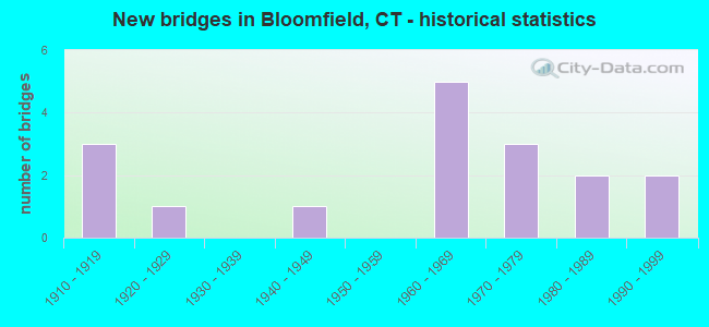
- New bridges - historical statistics
- 31910-1919
- 11920-1929
- 11940-1949
- 51960-1969
- 31970-1979
- 21980-1989
- 21990-1999

- Reconstructed bridges - Historical Statistics
- 41980-1989
- 01990-1999
- 02000-2009
- 12010-2019
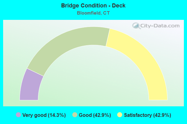
- Bridge Condition - Deck
- 14.3%Very good
- 42.9%Good
- 42.9%Satisfactory
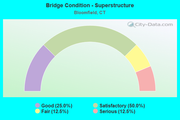
- Bridge Condition - Superstructure
- 25.0%Good
- 50.0%Satisfactory
- 12.5%Fair
- 12.5%Serious
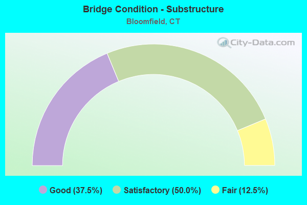
- Bridge Condition - Substructure
- 37.5%Good
- 50.0%Satisfactory
- 12.5%Fair
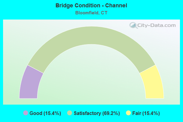
- Bridge Condition - Channel
- 15.4%Good
- 69.2%Satisfactory
- 15.4%Fair
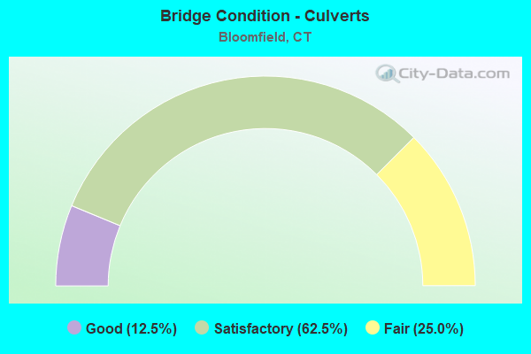
- Bridge Condition - Culverts
- 12.5%Good
- 62.5%Satisfactory
- 25.0%Fair
Find on map >> Show street view
Structure Number: 1488, Location: 0.1 MILES WEST OF RTE 189 (Lat: 41.830983, Lng: -72.738625), Route carried "on" structure: State highway 178, Year Built: 1926, Status: Open, Structure Length: 0.70m (2.30ft), Average Daily Traffic: 9,500 (year 2016), Truck Traffic: 4%, Average Future Daily Traffic: 14,116 (year 2036), Design Load: H 15, Features Intersected: WASH BROOK
Minimum Vertical Clearance: 30+ m (98+ ft), Kilometerpoint: 2.623, Lanes on structure: 3, Base Highway Network: Yes, Owner: State Highway Agency, Approaching Roadway Width: 11.6m (38.1ft), Material/Design: Concrete continuous, Design/Construction: Culvert, Number Of Spans In Main Unit: 3, Length of Maximum Span: 2.1m (6.9ft), Curb or Sidewalk Widths: Left: 1.9m (6.2ft), Right: 0.4m (1.3ft), Curb-To-Curb Width: 11.9m (39.0ft), Out-to-Out Width: 14.2m (46.6ft)
Condition: Channel: Satisfactory, Culverts: Fair, Operating Rating: 24.9 metric tons, Method Used To Determine Operating Rating: Load and Resistance Factor Rating (LRFR) rating reported by rating factor(RF) method using HL-93 loadings, Inventory Rating: 19.4 metric tons, Method Used To Determine Inventory Rating: Load and Resistance Factor Rating (LRFR) rating reported by rating factor(RF) method using HL-93 loadings, Structural Evaluation: Meets minimum limits, Deck Geometry: High priority of corrective action, Waterway Adequacy: Better than present minimum criteria, Approach Roadway Alignment: Equal to present desirable criteria, Designated Inspection Frequency: Every 24 months, Inspection Date: June 2021
Find on map >> Show street view
Structure Number: 1489, Location: 1.2 MI EAST OF ROUTE 189 (Lat: 41.823992, Lng: -72.720303), Route carried "on" structure: State highway 178, Year Built: 1915, Status: Open, Structure Length: 1.49m (4.89ft), Average Daily Traffic: 12,000 (year 2016), Truck Traffic: 4%, Average Future Daily Traffic: 17,831 (year 2036), Features Intersected: BEAMAN BROOK
Minimum Vertical Clearance: 30+ m (98+ ft), Kilometerpoint: 4.361, Lanes on structure: 2, Base Highway Network: Yes, Owner: State Highway Agency, Approaching Roadway Width: 9.1m (29.9ft), Material/Design: Concrete, Design/Construction: Tee Beam, Number Of Spans In Main Unit: 1, Length of Maximum Span: 14.0m (45.9ft), Curb or Sidewalk Widths: Left: 1.5m (4.9ft), Right: 1.5m (4.9ft), Curb-To-Curb Width: 9.8m (32.2ft), Out-to-Out Width: 10.5m (34.4ft)
Condition: Deck: Satisfactory, Superstructure: Serious, Substructure: Satisfactory, Channel: Satisfactory, Operating Rating: 33.4 metric tons, Method Used To Determine Operating Rating: Load and Resistance Factor Rating (LRFR) rating reported by rating factor(RF) method using HL-93 loadings, Inventory Rating: 25.6 metric tons, Method Used To Determine Inventory Rating: Load and Resistance Factor Rating (LRFR) rating reported by rating factor(RF) method using HL-93 loadings, Structural Evaluation: High priority of corrective action, Deck Geometry: Meets minimum limits, Waterway Adequacy: Better than present minimum criteria, Approach Roadway Alignment: Superior to present desirable criteria, Designated Inspection Frequency: Every 24 months, Inspection Date: June 2021, Total Project Cost: $1,325,000 ( Estimate for 2017), Deck Structure Type: Concrete Cast-file-Place, Wearing Surface/Protective System: Wearing Surface: Bituminous
Find on map >> Show street view
Structure Number: 1501, Location: 0.1 MILE WEST OF RTE. 218 (Lat: 41.806711, Lng: -72.752917), Route carried "on" structure: State highway 185, Year Built: 1949, Status: Open, Structure Length: 0.64m (2.10ft), Average Daily Traffic: 8,400 (year 2016), Truck Traffic: 4%, Average Future Daily Traffic: 12,482 (year 2036), Design Load: HS 20, Features Intersected: TUMBLE BROOK
Minimum Vertical Clearance: 30+ m (98+ ft), Kilometerpoint: 7.371, Lanes on structure: 2, Base Highway Network: Yes, Owner: State Highway Agency, Approaching Roadway Width: 11.9m (39.0ft), Material/Design: Concrete continuous, Design/Construction: Culvert, Number Of Spans In Main Unit: 2, Length of Maximum Span: 3.0m (9.8ft)
Condition: Channel: Satisfactory, Culverts: Satisfactory, Operating Rating: 36.0 metric tons, Method Used To Determine Operating Rating: Load and Resistance Factor Rating (LRFR) rating reported by rating factor(RF) method using HL-93 loadings, Inventory Rating: 27.9 metric tons, Method Used To Determine Inventory Rating: Load and Resistance Factor Rating (LRFR) rating reported by rating factor(RF) method using HL-93 loadings, Structural Evaluation: Equal to present minimum criteria, Waterway Adequacy: Better than present minimum criteria, Approach Roadway Alignment: Superior to present desirable criteria, Designated Inspection Frequency: Every 24 months, Inspection Date: June 2021
Find on map >> Show street view
Structure Number: 1502, Location: 0.5 MI NO. OF JCT RTE 187 (Lat: 41.887939, Lng: -72.748814), Route carried "on" structure: State highway 189, Year Built: 1960, Year Reconstructed: 1993, Status: Open, Structure Length: 4.91m (16.11ft), Average Daily Traffic: 9,450 (year 2018), Truck Traffic: 6%, Average Future Daily Traffic: 14,042 (year 2038), Design Load: HS 20, Features Intersected: TARIFFVILLE ROAD #1
Minimum Vertical Clearance: 30+ m (98+ ft), Kilometerpoint: 12.279, Lanes on structure: 3, Lanes under structure: 2, Base Highway Network: Yes, Owner: State Highway Agency, Approaching Roadway Width: 15.5m (50.9ft), Skew: 4 degrees, Material/Design: Steel, Design/Construction: Stringer/Multi-beam, Number Of Spans In Main Unit: 3, Length of Maximum Span: 21.9m (71.9ft), Curb-To-Curb Width: 15.5m (50.9ft), Out-to-Out Width: 16.7m (54.8ft)
Condition: Deck: Satisfactory, Superstructure: Satisfactory, Substructure: Satisfactory, Inventory Rating: 62.1 metric tons, Method Used To Determine Inventory Rating: Load Factor (LF), Structural Evaluation: Equal to present minimum criteria, Deck Geometry: Equal to present minimum criteria, Underclear: Equal to present minimum criteria, Approach Roadway Alignment: Equal to present desirable criteria, Designated Inspection Frequency: Every 24 months, Inspection Date: January 2020, Deck Structure Type: Concrete Cast-file-Place, Wearing Surface/Protective System: Wearing Surface: Bituminous, Membrane: Preformed Fabric, Deck Protection: Epoxy Coated Reinforcing
Find on map >> Show street view
Structure Number: 1503, Location: 0.5 MI NO. OF JCT RTE 187 (Lat: 41.887756, Lng: -72.748489), Route carried "on" structure: State highway 189, Year Built: 1960, Year Reconstructed: 1993, Status: Open, Structure Length: 5.18m (16.99ft), Average Daily Traffic: 9,450 (year 2018), Truck Traffic: 6%, Average Future Daily Traffic: 14,042 (year 2038), Design Load: HS 20, Features Intersected: TARIFFVILLE ROAD #1
Minimum Vertical Clearance: 30+ m (98+ ft), Kilometerpoint: 12.263, Lanes on structure: 3, Lanes under structure: 2, Base Highway Network: Yes, Owner: State Highway Agency, Approaching Roadway Width: 15.2m (49.9ft), Skew: 4 degrees, Material/Design: Steel, Design/Construction: Stringer/Multi-beam, Number Of Spans In Main Unit: 3, Length of Maximum Span: 22.9m (75.1ft), Curb-To-Curb Width: 15.5m (50.9ft), Out-to-Out Width: 16.7m (54.8ft)
Condition: Deck: Good, Superstructure: Satisfactory, Substructure: Satisfactory, Operating Rating: 39.9 metric tons, Method Used To Determine Operating Rating: Load and Resistance Factor Rating (LRFR) rating reported by rating factor(RF) method using HL-93 loadings, Inventory Rating: 30.8 metric tons, Method Used To Determine Inventory Rating: Load and Resistance Factor Rating (LRFR) rating reported by rating factor(RF) method using HL-93 loadings, Structural Evaluation: Equal to present minimum criteria, Deck Geometry: Equal to present minimum criteria, Underclear: Meets minimum limits, Approach Roadway Alignment: Equal to present desirable criteria, Designated Inspection Frequency: Every 24 months, Inspection Date: January 2020, Deck Structure Type: Concrete Cast-file-Place, Wearing Surface/Protective System: Wearing Surface: Bituminous, Membrane: Preformed Fabric, Deck Protection: Epoxy Coated Reinforcing
Find on map >> Show street view
Structure Number: 1504, Location: 1 MI SOUTH OF SIMSBURY TL (Lat: 41.895367, Lng: -72.750300), Route carried "on" structure: State highway 189, Year Built: 1960, Year Reconstructed: 1992, Status: Open, Structure Length: 2.23m (7.32ft), Average Daily Traffic: 12,300 (year 2018), Truck Traffic: 4%, Average Future Daily Traffic: 18,277 (year 2038), Design Load: HS 20, Features Intersected: ROUTE 187
Minimum Vertical Clearance: 30+ m (98+ ft), Kilometerpoint: 13.164, Lanes on structure: 2, Lanes under structure: 2, Base Highway Network: Yes, Owner: State Highway Agency, Approaching Roadway Width: 13.7m (44.9ft), Skew: 22 degrees, Material/Design: Steel, Design/Construction: Stringer/Multi-beam, Number Of Spans In Main Unit: 1, Length of Maximum Span: 20.8m (68.2ft), Curb-To-Curb Width: 18.8m (61.7ft), Out-to-Out Width: 20.0m (65.6ft)
Condition: Deck: Good, Superstructure: Satisfactory, Substructure: Fair, Operating Rating: 88.5 metric tons, Method Used To Determine Operating Rating: Load Factor (LF), Inventory Rating: 53.2 metric tons, Method Used To Determine Inventory Rating: Load Factor (LF), Structural Evaluation: Somewhat better than minimum adequacy, Deck Geometry: Superior to present desirable criteria, Underclear: Somewhat better than minimum adequacy, Approach Roadway Alignment: Equal to present desirable criteria, Designated Inspection Frequency: Every 24 months, Inspection Date: September 2021, Deck Structure Type: Concrete Cast-file-Place, Wearing Surface/Protective System: Wearing Surface: Bituminous, Membrane: Preformed Fabric, Deck Protection: Epoxy Coated Reinforcing
Find on map >> Show street view
Structure Number: 1505, Location: AT EAST GRANBY TOWN LINE (Lat: 41.897039, Lng: -72.749314), Route carried "on" structure: State highway 187, Year Built: 1960, Year Reconstructed: 1992, Status: Open, Structure Length: 14.17m (46.49ft), Average Daily Traffic: 8,900 (year 2019), Truck Traffic: 3%, Average Future Daily Traffic: 13,225 (year 2039), Design Load: HS 20, Features Intersected: FARMINGTON RV& TUNXIS AV
Minimum Vertical Clearance: 30+ m (98+ ft), Kilometerpoint: 14.404, Lanes on structure: 2, Lanes under structure: 2, Owner: State Highway Agency, Approaching Roadway Width: 12.3m (40.4ft), Skew: 1 degrees, Material/Design: Steel continuous, Design/Construction: Stringer/Multi-beam, Number Of Spans In Main Unit: 3, Number Of Approach Spans: 1, Length of Maximum Span: 35.1m (115.2ft), Curb or Sidewalk Widths: Left: 0.0m, Right: 1.7m (5.6ft), Curb-To-Curb Width: 12.3m (40.4ft), Out-to-Out Width: 15.0m (49.2ft)
Condition: Deck: Good, Superstructure: Fair, Substructure: Satisfactory, Channel: Good, Operating Rating: 21.1 metric tons, Method Used To Determine Operating Rating: Load and Resistance Factor Rating (LRFR) rating reported by rating factor(RF) method using HL-93 loadings, Inventory Rating: 16.2 metric tons, Method Used To Determine Inventory Rating: Load and Resistance Factor Rating (LRFR) rating reported by rating factor(RF) method using HL-93 loadings, Structural Evaluation: Meets minimum limits, Deck Geometry: Somewhat better than minimum adequacy, Underclear: Somewhat better than minimum adequacy, Waterway Adequacy: Equal to present desirable criteria, Approach Roadway Alignment: Equal to present desirable criteria, Designated Inspection Frequency: Every 24 months, Inspection Date: November 2021, Deck Structure Type: Concrete Cast-file-Place, Wearing Surface/Protective System: Wearing Surface: Bituminous, Membrane: Preformed Fabric, Deck Protection: Epoxy Coated Reinforcing
Find on map >> Show street view
Structure Number: 1508, Location: 0.2 MILE NORTH OF RTE 218 (Lat: 41.819197, Lng: -72.739128), Route carried "on" structure: State highway 189, Year Built: 1913, Status: Open, Structure Length: 1.01m (3.31ft), Average Daily Traffic: 15,700 (year 2016), Truck Traffic: 4%, Average Future Daily Traffic: 23,329 (year 2036), Features Intersected: WASH BROOK
Minimum Vertical Clearance: 30+ m (98+ ft), Kilometerpoint: 4.233, Lanes on structure: 2, Base Highway Network: Yes, Owner: State Highway Agency, Approaching Roadway Width: 9.8m (32.2ft), Material/Design: Concrete, Design/Construction: Arch - Deck, Number Of Spans In Main Unit: 1, Length of Maximum Span: 10.1m (33.1ft), Curb-To-Curb Width: 7.3m (24.0ft), Out-to-Out Width: 7.8m (25.6ft)
Condition: Superstructure: Satisfactory, Substructure: Good, Channel: Satisfactory, Operating Rating: 42.6 metric tons, Method Used To Determine Operating Rating: Field evaluation and documented engineering judgment, Inventory Rating: 32.7 metric tons, Method Used To Determine Inventory Rating: Field evaluation and documented engineering judgment, Structural Evaluation: Equal to present minimum criteria, Deck Geometry: High priority of replacement, Waterway Adequacy: Equal to present desirable criteria, Approach Roadway Alignment: Equal to present desirable criteria, Designated Inspection Frequency: Every 24 months, Inspection Date: January 2021
Find on map >> Show street view
Structure Number: 1509, Location: 0.4 MILE NORTH OF RTE 178 (Lat: 41.836394, Lng: -72.738864), Route carried "on" structure: State highway 189, Year Built: 1916, Year Reconstructed: 2018, Status: Open, Structure Length: 0.85m (2.79ft), Average Daily Traffic: 9,200 (year 2016), Truck Traffic: 4%, Average Future Daily Traffic: 13,670 (year 2036), Design Load: HL 93, Features Intersected: WASH BROOK
Minimum Vertical Clearance: 30+ m (98+ ft), Kilometerpoint: 6.212, Lanes on structure: 2, Base Highway Network: Yes, Owner: State Highway Agency, Approaching Roadway Width: 10.1m (33.1ft), Material/Design: Steel, Design/Construction: Stringer/Multi-beam, Number Of Spans In Main Unit: 1, Length of Maximum Span: 6.7m (22.0ft), Curb or Sidewalk Widths: Left: 0.0m, Right: 2.4m (7.9ft), Curb-To-Curb Width: 10.1m (33.1ft), Out-to-Out Width: 13.3m (43.6ft)
Condition: Deck: Very good, Superstructure: Good, Substructure: Good, Channel: Satisfactory, Operating Rating: 97.2 metric tons, Method Used To Determine Operating Rating: Load and Resistance Factor Rating (LRFR) rating reported by rating factor(RF) method using HL-93 loadings, Inventory Rating: 94.3 metric tons, Method Used To Determine Inventory Rating: Load and Resistance Factor Rating (LRFR) rating reported by rating factor(RF) method using HL-93 loadings, Structural Evaluation: Better than present minimum criteria, Deck Geometry: Meets minimum limits, Waterway Adequacy: Better than present minimum criteria, Approach Roadway Alignment: Equal to present desirable criteria, Designated Inspection Frequency: Every 24 months, Inspection Date: July 2020, Deck Structure Type: Concrete Cast-file-Place, Wearing Surface/Protective System: Wearing Surface: Bituminous, Membrane: Preformed Fabric
Find on map >> Show street view
Structure Number: 435, Location: 1 MILE WEST OF ROUTE 189 (Lat: 41.825550, Lng: -72.739358), Route carried "on" structure: City street , Year Built: 1981, Status: Open, Structure Length: 0.67m (2.20ft), Average Daily Traffic: 1,926 (year 2021), Truck Traffic: 2%, Average Future Daily Traffic: 2,862 (year 2041), Features Intersected: WASH BROOK, Facility Carried by Structure: GABB ROAD
Minimum Vertical Clearance: 30+ m (98+ ft), Kilometerpoint: 0.000, Lanes on structure: 2, Owner: Town or Township Highway Agency, Approaching Roadway Width: 7.9m (25.9ft), Material/Design: Concrete, Design/Construction: Culvert, Number Of Spans In Main Unit: 2, Length of Maximum Span: 3.0m (9.8ft), Curb or Sidewalk Widths: Left: 1.9m (6.2ft), Right: 1.3m (4.3ft), Curb-To-Curb Width: 8.1m (26.6ft), Out-to-Out Width: 12.3m (40.4ft)
Condition: Channel: Satisfactory, Culverts: Satisfactory, Operating Rating: 42.6 metric tons, Method Used To Determine Operating Rating: Field evaluation and documented engineering judgment, Inventory Rating: 32.7 metric tons, Method Used To Determine Inventory Rating: Field evaluation and documented engineering judgment, Structural Evaluation: Equal to present minimum criteria, Deck Geometry: Meets minimum limits, Waterway Adequacy: Better than present minimum criteria, Approach Roadway Alignment: Equal to present desirable criteria, Designated Inspection Frequency: Every 24 months, Inspection Date: September 2021
Find on map >> Show street view
Structure Number: 4479, Location: 400' EAST OF ROUTE 189 (Lat: 41.839986, Lng: -72.740239), Route carried "on" structure: City street , Year Built: 1974, Status: Open, Structure Length: 0.82m (2.69ft), Average Daily Traffic: 1,413 (year 2021), Truck Traffic: 2%, Average Future Daily Traffic: 2,100 (year 2041), Features Intersected: WASH BROOK, Facility Carried by Structure: MILLS LANE #1
Minimum Vertical Clearance: 30+ m (98+ ft), Kilometerpoint: 0.000, Lanes on structure: 2, Owner: Town or Township Highway Agency, Approaching Roadway Width: 8.2m (26.9ft), Skew: 2 degrees, Material/Design: Steel, Design/Construction: Culvert, Number Of Spans In Main Unit: 2, Length of Maximum Span: 3.7m (12.1ft)
Condition: Channel: Satisfactory, Culverts: Fair, Operating Rating: 55.7 metric tons, Method Used To Determine Operating Rating: Load and Resistance Factor Rating (LRFR) rating reported by rating factor(RF) method using HL-93 loadings, Inventory Rating: 43.1 metric tons, Method Used To Determine Inventory Rating: Load and Resistance Factor Rating (LRFR) rating reported by rating factor(RF) method using HL-93 loadings, Structural Evaluation: Somewhat better than minimum adequacy, Waterway Adequacy: Equal to present desirable criteria, Approach Roadway Alignment: Equal to present desirable criteria, Designated Inspection Frequency: Every 24 months, Inspection Date: September 2021
Find on map >> Show street view
Structure Number: 5243, Location: 100 FT EAST OF ROUTE 189 (Lat: 41.816872, Lng: -72.737767), Route carried "on" structure: State highway 218, Year Built: 1982, Status: Open, Structure Length: 1.19m (3.90ft), Average Daily Traffic: 24,400 (year 2016), Truck Traffic: 4%, Average Future Daily Traffic: 36,256 (year 2036), Features Intersected: WASH BROOK
Minimum Vertical Clearance: 30+ m (98+ ft), Kilometerpoint: 4.377, Lanes on structure: 5, Base Highway Network: Yes, Owner: State Highway Agency, Approaching Roadway Width: 19.5m (64.0ft), Skew: 21 degrees, Material/Design: Concrete, Design/Construction: Culvert, Number Of Spans In Main Unit: 3, Length of Maximum Span: 3.4m (11.2ft), Curb or Sidewalk Widths: Left: 2.1m (6.9ft), Right: 2.1m (6.9ft), Curb-To-Curb Width: 23.3m (76.4ft), Out-to-Out Width: 28.3m (92.8ft)
Condition: Channel: Satisfactory, Culverts: Satisfactory, Operating Rating: 72.6 metric tons, Method Used To Determine Operating Rating: Field evaluation and documented engineering judgment, Inventory Rating: 45.4 metric tons, Method Used To Determine Inventory Rating: Field evaluation and documented engineering judgment, Structural Evaluation: Equal to present minimum criteria, Deck Geometry: Better than present minimum criteria, Waterway Adequacy: Better than present minimum criteria, Approach Roadway Alignment: Equal to present desirable criteria, Designated Inspection Frequency: Every 24 months, Inspection Date: June 2021
Find on map >> Show street view
Structure Number: 6144, Location: 0.1 MILE WEST OF SR 218 (Lat: 41.817181, Lng: -72.749117), Route carried "on" structure: City street , Year Built: 1975, Status: Open, Structure Length: 0.70m (2.30ft), Average Daily Traffic: 1,930 (year 2021), Truck Traffic: 4%, Average Future Daily Traffic: 2,868 (year 2041), Features Intersected: TUMBLE BROOK, Facility Carried by Structure: COTTAGE GROVE RD#2
Minimum Vertical Clearance: 30+ m (98+ ft), Kilometerpoint: 0.161, Lanes on structure: 2, Owner: Town or Township Highway Agency, Approaching Roadway Width: 9.4m (30.8ft), Material/Design: Steel, Design/Construction: Culvert, Number Of Spans In Main Unit: 2, Length of Maximum Span: 3.4m (11.2ft)
Condition: Channel: Satisfactory, Culverts: Good, Operating Rating: 52.6 metric tons, Method Used To Determine Operating Rating: Field evaluation and documented engineering judgment, Inventory Rating: 32.7 metric tons, Method Used To Determine Inventory Rating: Field evaluation and documented engineering judgment, Structural Evaluation: Better than present minimum criteria, Waterway Adequacy: Better than present minimum criteria, Approach Roadway Alignment: Equal to present desirable criteria, Designated Inspection Frequency: Every 24 months, Inspection Date: September 2021
Find on map >> Show street view
Structure Number: 6201, Location: 0.2 MILE FROM ROUTE 189 (Lat: 41.846967, Lng: -72.742286), Route carried "on" structure: City street , Year Built: 1973, Status: Open, Structure Length: 0.98m (3.22ft), Average Daily Traffic: 128 (year 2021), Truck Traffic: 7%, Average Future Daily Traffic: 190 (year 2041), Features Intersected: WASH BROOK, Facility Carried by Structure: DOROTHY DRIVE
Minimum Vertical Clearance: 30+ m (98+ ft), Kilometerpoint: 14.484, Lanes on structure: 2, Owner: Town or Township Highway Agency, Approaching Roadway Width: 9.1m (29.9ft), Skew: 3 degrees, Material/Design: Concrete, Design/Construction: Culvert, Number Of Spans In Main Unit: 2, Length of Maximum Span: 4.6m (15.1ft), Curb-To-Curb Width: 9.1m (29.9ft), Out-to-Out Width: 15.6m (51.2ft)
Condition: Channel: Fair, Culverts: Satisfactory, Operating Rating: 42.6 metric tons, Method Used To Determine Operating Rating: Field evaluation and documented engineering judgment, Inventory Rating: 32.7 metric tons, Method Used To Determine Inventory Rating: Field evaluation and documented engineering judgment, Structural Evaluation: Equal to present minimum criteria, Deck Geometry: Equal to present minimum criteria, Waterway Adequacy: Better than present minimum criteria, Approach Roadway Alignment: Equal to present desirable criteria, Designated Inspection Frequency: Every 24 months, Inspection Date: September 2021
Find on map >> Show street view
Structure Number: 6208, Location: 1.4 MILES W OF ROUTE 187 (Lat: 41.817403, Lng: -72.721178), Route carried "on" structure: State highway 218, Year Built: 1992, Status: Open, Structure Length: 1.62m (5.31ft), Average Daily Traffic: 23,700 (year 2016), Truck Traffic: 4%, Average Future Daily Traffic: 35,216 (year 2036), Design Load: HS 20, Features Intersected: BEAMANS BROOK
Minimum Vertical Clearance: 30+ m (98+ ft), Kilometerpoint: 5.761, Lanes on structure: 4, Base Highway Network: Yes, Owner: State Highway Agency, Approaching Roadway Width: 13.4m (44.0ft), Skew: 33 degrees, Material/Design: Prestressed concrete, Design/Construction: Channel Beam, Number Of Spans In Main Unit: 1, Length of Maximum Span: 14.0m (45.9ft), Curb or Sidewalk Widths: Left: 1.7m (5.6ft), Right: 1.7m (5.6ft), Curb-To-Curb Width: 24.4m (80.1ft), Out-to-Out Width: 30.3m (99.4ft)
Condition: Deck: Satisfactory, Superstructure: Good, Substructure: Good, Channel: Good, Operating Rating: 33.7 metric tons, Method Used To Determine Operating Rating: Load and Resistance Factor Rating (LRFR) rating reported by rating factor(RF) method using HL-93 loadings, Inventory Rating: 25.9 metric tons, Method Used To Determine Inventory Rating: Load and Resistance Factor Rating (LRFR) rating reported by rating factor(RF) method using HL-93 loadings, Structural Evaluation: Equal to present minimum criteria, Deck Geometry: Superior to present desirable criteria, Waterway Adequacy: Equal to present desirable criteria, Approach Roadway Alignment: Equal to present desirable criteria, Designated Inspection Frequency: Every 24 months, Inspection Date: August 2021, Deck Structure Type: Concrete Cast-file-Place, Wearing Surface/Protective System: Wearing Surface: Bituminous, Membrane: Preformed Fabric, Deck Protection: Epoxy Coated Reinforcing
Find on map >> Show street view
Structure Number: 6297, Location: .5MI EAST OF ROUTE 189 (Lat: 41.817172, Lng: -72.727917), Route carried "on" structure: State highway 218, Year Built: 1992, Status: Open, Structure Length: 0.64m (2.10ft), Average Daily Traffic: 23,700 (year 2016), Truck Traffic: 6%, Average Future Daily Traffic: 35,216 (year 2036), Features Intersected: MUCKY BROOK
Minimum Vertical Clearance: 30+ m (98+ ft), Kilometerpoint: 5.118, Lanes on structure: 5, Base Highway Network: Yes, Owner: State Highway Agency, Approaching Roadway Width: 26.2m (86.0ft), Skew: 29 degrees, Material/Design: Concrete, Design/Construction: Culvert, Number Of Spans In Main Unit: 2, Length of Maximum Span: 3.0m (9.8ft)
Condition: Channel: Fair, Culverts: Satisfactory, Operating Rating: 42.6 metric tons, Method Used To Determine Operating Rating: Field evaluation and documented engineering judgment, Inventory Rating: 32.7 metric tons, Method Used To Determine Inventory Rating: Field evaluation and documented engineering judgment, Structural Evaluation: Equal to present minimum criteria, Waterway Adequacy: Better than present minimum criteria, Approach Roadway Alignment: Equal to present desirable criteria, Designated Inspection Frequency: Every 24 months, Underwater Inspection Frequency: Every 24 months, Inspection Date: May 2020, Underwater Inspection Date: May 2020
Find on map >> Show street view
Structure Number: 1504, Location: 1 MI SOUTH OF SIMSBURY TL (Lat: 41.895367, Lng: -72.750300), Route carried "under" structure: State highway 187, Year Built: 1960, Structure Length: 0. m, Average Daily Traffic: 7,400 (year 2018), Truck Traffic: 1%, Features Intersected: ROUTE 187, Facility Carried by Structure: RT 189 NB & RAMP 6
Minimum Vertical Clearance: 4.47m (14.67ft), Kilometerpoint: 14.275, Lanes on structure: 2, Lanes under structure: 2, Material/Design: Steel, Design/Construction: Stringer/Multi-beam, Length of Maximum Span: 20.8m (68.2ft)