Bridge Statistics for Bonita Springs, Florida (FL)
Condition, Traffic, Stress, Structural Evaluation, Project Costs
- National Bridge Inventory (NBI) Statistics
- 36Number of bridges
- 643ft / 196mTotal length
- 813,746Total average daily traffic
- 74,535Total average daily truck traffic
- National Bridge Inventory (NBI) Registered Bridges for Bonita Springs
- No street view available for this location
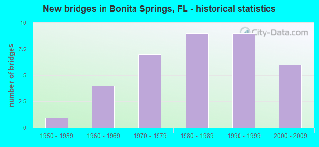
- New bridges - historical statistics
- 11950-1959
- 41960-1969
- 71970-1979
- 91980-1989
- 91990-1999
- 62000-2009
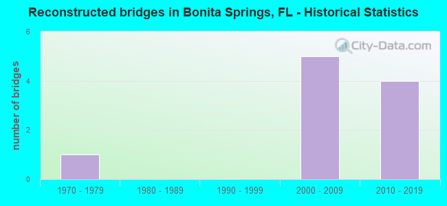
- Reconstructed bridges - Historical Statistics
- 11970-1979
- 01980-1989
- 01990-1999
- 52000-2009
- 42010-2019
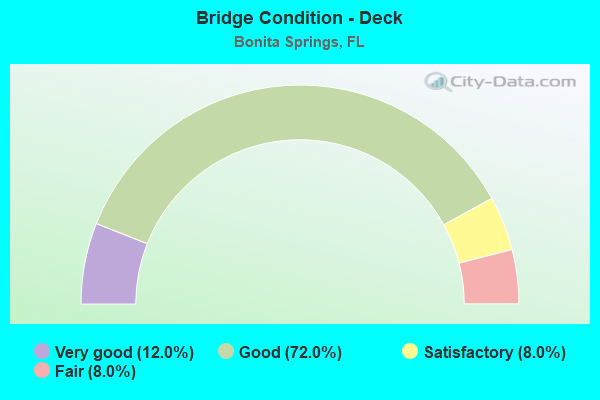
- Bridge Condition - Deck
- 12.0%Very good
- 72.0%Good
- 8.0%Satisfactory
- 8.0%Fair
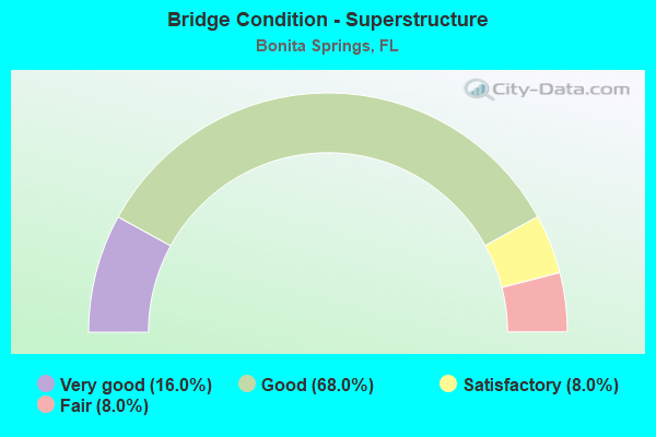
- Bridge Condition - Superstructure
- 16.0%Very good
- 68.0%Good
- 8.0%Satisfactory
- 8.0%Fair
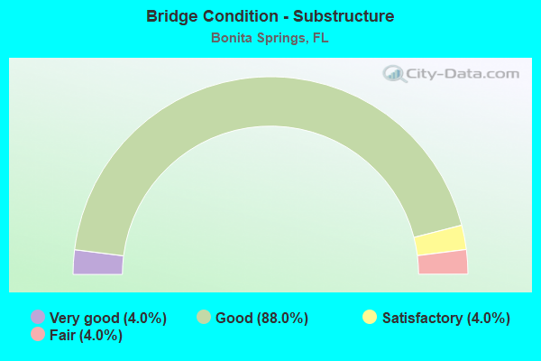
- Bridge Condition - Substructure
- 4.0%Very good
- 88.0%Good
- 4.0%Satisfactory
- 4.0%Fair
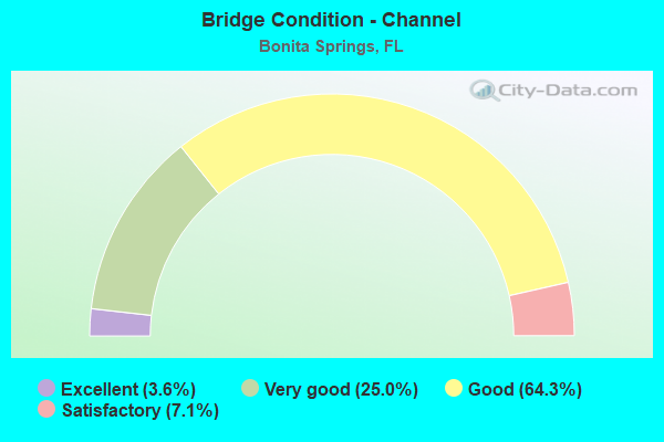
- Bridge Condition - Channel
- 3.6%Excellent
- 25.0%Very good
- 64.3%Good
- 7.1%Satisfactory
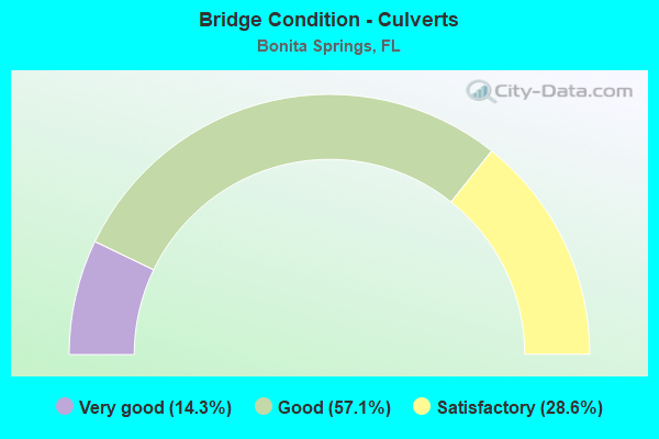
- Bridge Condition - Culverts
- 14.3%Very good
- 57.1%Good
- 28.6%Satisfactory
Find on map >> Show street view
Structure Number: 30181, Location: AT JUNCTION US-41/CR-887 (Lat: 26.298039, Lng: -81.802444), Route carried "on" structure: US 41, Year Built: 1974, Status: Open, Structure Length: 0.79m (2.59ft), Average Daily Traffic: 40,000 (year 2021), Truck Traffic: 4%, Average Future Daily Traffic: 69,400 (year 2041), Design Load: HS 20+Mod, Features Intersected: DUNRUSS CREEK
Minimum Vertical Clearance: 30+ m (98+ ft), Kilometerpoint: 2.039, Lanes on structure: 8, Base Highway Network: Yes, Owner: State Highway Agency, Approaching Roadway Width: 33.6m (110.2ft), Skew: 15 degrees, Material/Design: Concrete, Design/Construction: Culvert, Number Of Spans In Main Unit: 2, Length of Maximum Span: 4.0m (13.1ft)
Condition: Channel: Good, Culverts: Good, Inventory Rating: 76.9 metric tons, Method Used To Determine Inventory Rating: Load Factor (LF), Structural Evaluation: Better than present minimum criteria, Waterway Adequacy: Equal to present desirable criteria, Approach Roadway Alignment: Equal to present desirable criteria, Designated Inspection Frequency: Every 24 months, Inspection Date: April 2021
Find on map >> Show street view
Structure Number: 120022, Location: 6.5mi. NW OF US 41 (Lat: 26.378025, Lng: -81.860989), Route carried "on" structure: County highway 865, Year Built: 1965, Status: Open, Structure Length: 28.53m (93.60ft), Average Daily Traffic: 8,100 (year 2021), Truck Traffic: 10%, Average Future Daily Traffic: 8,505 (year 2041), Design Load: HS 20, Features Intersected: NEW PASS
Minimum Vertical Clearance: 30+ m (98+ ft), Kilometerpoint: 2.239, Lanes on structure: 2, Owner: County Highway Agency, Approaching Roadway Width: 7.9m (25.9ft), Navigation Control: Yes ( Vertical Clearance: 9.4m (30.8ft), Horizontal Clearance: 15.5m (50.9ft)), Material/Design: Prestressed concrete, Design/Construction: Stringer/Multi-beam, Number Of Spans In Main Unit: 19, Length of Maximum Span: 21.9m (71.9ft), Curb or Sidewalk Widths: Left: 0.9m (3.0ft), Right: 0.9m (3.0ft), Curb-To-Curb Width: 7.9m (25.9ft), Out-to-Out Width: 11.6m (38.1ft)
Condition: Deck: Good, Superstructure: Good, Substructure: Good, Channel: Good, Operating Rating: 40.5 metric tons, Method Used To Determine Operating Rating: Load Factor (LF), Inventory Rating: 24.1 metric tons, Method Used To Determine Inventory Rating: Load Factor (LF), Structural Evaluation: Somewhat better than minimum adequacy, Deck Geometry: High priority of corrective action, Waterway Adequacy: Superior to present desirable criteria, Approach Roadway Alignment: Better than present minimum criteria, Designated Inspection Frequency: Every 24 months, Underwater Inspection Frequency: Every 24 months, Inspection Date: August 2021, Underwater Inspection Date: July 2021, Deck Structure Type: Concrete Cast-file-Place, Wearing Surface/Protective System: Wearing Surface: Epoxy Overlay
Find on map >> Show street view
Structure Number: 120023, Location: 0.2MI NORTH OF CR 865 (Lat: 26.333897, Lng: -81.778842), Route carried "on" structure: County highway 887, Year Built: 1960, Status: Open, Structure Length: 1.09m (3.58ft), Average Daily Traffic: 14,400 (year 2021), Truck Traffic: 2%, Average Future Daily Traffic: 17,280 (year 2041), Design Load: H 15, Features Intersected: OAK CREEK
Minimum Vertical Clearance: 30+ m (98+ ft), Kilometerpoint: 2.213, Lanes on structure: 2, Owner: City or Municipal Highway Agency, Approaching Roadway Width: 9.9m (32.5ft), Skew: 3 degrees, Material/Design: Concrete, Design/Construction: Culvert, Number Of Spans In Main Unit: 3, Length of Maximum Span: 3.3m (10.8ft), Curb or Sidewalk Widths: Left: 1.5m (4.9ft), Right: 1.5m (4.9ft), Curb-To-Curb Width: 9.9m (32.5ft), Out-to-Out Width: 18.3m (60.0ft)
Condition: Channel: Satisfactory, Culverts: Good, Operating Rating: 86.2 metric tons, Method Used To Determine Operating Rating: Load Factor (LF), Inventory Rating: 51.6 metric tons, Method Used To Determine Inventory Rating: Load Factor (LF), Structural Evaluation: Better than present minimum criteria, Deck Geometry: Meets minimum limits, Waterway Adequacy: Better than present minimum criteria, Approach Roadway Alignment: Better than present minimum criteria, Designated Inspection Frequency: Every 24 months, Underwater Inspection Frequency: Every 24 months, Inspection Date: July 2021, Underwater Inspection Date: June 2021
Find on map >> Show street view
Structure Number: 120026, Location: 4.5 Mi. W of US-41 (Lat: 26.360000, Lng: -81.857986), Route carried "on" structure: County highway 865, Year Built: 1965, Status: Open, Structure Length: 16.82m (55.18ft), Average Daily Traffic: 7,910 (year 2021), Truck Traffic: 5%, Average Future Daily Traffic: 8,306 (year 2041), Design Load: H 20, Features Intersected: BIG HICKORY PASS, Facility Carried by Structure: Bonita Beach Road
Minimum Vertical Clearance: 30+ m (98+ ft), Kilometerpoint: 0.196, Lanes on structure: 2, Owner: County Highway Agency, Approaching Roadway Width: 7.9m (25.9ft), Material/Design: Prestressed concrete, Design/Construction: Stringer/Multi-beam, Number Of Spans In Main Unit: 11, Length of Maximum Span: 21.9m (71.9ft), Curb or Sidewalk Widths: Left: 0.9m (3.0ft), Right: 0.9m (3.0ft), Curb-To-Curb Width: 7.9m (25.9ft), Out-to-Out Width: 11.5m (37.7ft)
Condition: Deck: Good, Superstructure: Good, Substructure: Good, Channel: Good, Operating Rating: 40.5 metric tons, Method Used To Determine Operating Rating: Load Factor (LF), Inventory Rating: 24.1 metric tons, Method Used To Determine Inventory Rating: Load Factor (LF), Structural Evaluation: Somewhat better than minimum adequacy, Deck Geometry: High priority of corrective action, Waterway Adequacy: Equal to present desirable criteria, Approach Roadway Alignment: Equal to present desirable criteria, Designated Inspection Frequency: Every 24 months, Underwater Inspection Frequency: Every 24 months, Inspection Date: August 2021, Underwater Inspection Date: July 2021, Deck Structure Type: Concrete Cast-file-Place, Wearing Surface/Protective System: Wearing Surface: Epoxy Overlay
Find on map >> Show street view
Structure Number: 120055, Location: 8 Mi. NW of US-41 (Lat: 26.400211, Lng: -81.870358), Route carried "on" structure: County highway 865, Year Built: 1965, Status: Open, Structure Length: 7.32m (24.02ft), Average Daily Traffic: 8,110 (year 2021), Truck Traffic: 5%, Average Future Daily Traffic: 8,516 (year 2041), Design Load: H 20, Features Intersected: LITTLE CARLOS PASS
Minimum Vertical Clearance: 30+ m (98+ ft), Kilometerpoint: 4.971, Lanes on structure: 2, Owner: County Highway Agency, Approaching Roadway Width: 8.0m (26.2ft), Material/Design: Prestressed concrete, Design/Construction: Stringer/Multi-beam, Number Of Spans In Main Unit: 5, Length of Maximum Span: 14.8m (48.6ft), Curb or Sidewalk Widths: Left: 1.0m (3.3ft), Right: 1.0m (3.3ft), Curb-To-Curb Width: 8.0m (26.2ft), Out-to-Out Width: 11.6m (38.1ft)
Condition: Deck: Good, Superstructure: Good, Substructure: Good, Channel: Good, Operating Rating: 43.7 metric tons, Method Used To Determine Operating Rating: Load Factor (LF), Inventory Rating: 25.5 metric tons, Method Used To Determine Inventory Rating: Load Factor (LF), Structural Evaluation: Equal to present minimum criteria, Deck Geometry: High priority of corrective action, Waterway Adequacy: Equal to present desirable criteria, Approach Roadway Alignment: Equal to present desirable criteria, Designated Inspection Frequency: Every 24 months, Underwater Inspection Frequency: Every 24 months, Inspection Date: August 2021, Underwater Inspection Date: July 2021, Deck Structure Type: Concrete Cast-file-Place
Find on map >> Show street view
Structure Number: 120085, Location: 0.5MI N of SR-865 (Lat: 26.339344, Lng: -81.806694), Route carried "on" structure: US 41, Year Built: 1976, Year Reconstructed: 2006, Status: Open, Structure Length: 24.99m (81.99ft), Average Daily Traffic: 44,000 (year 2020), Truck Traffic: 5%, Average Future Daily Traffic: 76,340 (year 2042), Design Load: HL 93, Features Intersected: IMPERIAL RIVER
Minimum Vertical Clearance: 30+ m (98+ ft), Kilometerpoint: 2.383, Lanes on structure: 6, Base Highway Network: Yes, Owner: State Highway Agency, Approaching Roadway Width: 28.8m (94.5ft), Skew: 20 degrees, Material/Design: Prestressed concrete, Design/Construction: Stringer/Multi-beam, Number Of Spans In Main Unit: 12, Length of Maximum Span: 20.9m (68.6ft), Curb or Sidewalk Widths: Left: 1.7m (5.6ft), Right: 1.7m (5.6ft), Curb-To-Curb Width: 28.8m (94.5ft), Out-to-Out Width: 38.7m (127.0ft)
Condition: Deck: Good, Superstructure: Very good, Substructure: Very good, Channel: Good, Operating Rating: 43.1 metric tons, Method Used To Determine Operating Rating: Load and Resistance Factor (LRFR), Inventory Rating: 34.9 metric tons, Method Used To Determine Inventory Rating: Load and Resistance Factor (LRFR), Structural Evaluation: Equal to present desirable criteria, Deck Geometry: Superior to present desirable criteria, Waterway Adequacy: Equal to present desirable criteria, Approach Roadway Alignment: Equal to present desirable criteria, Designated Inspection Frequency: Every 24 months, Underwater Inspection Frequency: Every 24 months, Inspection Date: July 2020, Underwater Inspection Date: June 2020, Deck Structure Type: Concrete Cast-file-Place
Find on map >> Show street view
Structure Number: 120095, Location: 0.5MI N. OF NORTH BAY DR (Lat: 26.365097, Lng: -81.807786), Route carried "on" structure: US 41, Year Built: 1976, Year Reconstructed: 2006, Status: Open, Structure Length: 4.42m (14.50ft), Average Daily Traffic: 39,500 (year 2020), Truck Traffic: 5%, Average Future Daily Traffic: 68,532 (year 2042), Design Load: HL 93, Features Intersected: SPRING CREEK
Minimum Vertical Clearance: 30+ m (98+ ft), Kilometerpoint: 5.396, Lanes on structure: 6, Base Highway Network: Yes, Owner: State Highway Agency, Approaching Roadway Width: 26.5m (86.9ft), Skew: 20 degrees, Material/Design: Prestressed concrete, Design/Construction: Slab, Number Of Spans In Main Unit: 5, Length of Maximum Span: 9.4m (30.8ft), Curb or Sidewalk Widths: Left: 1.7m (5.6ft), Right: 1.7m (5.6ft), Curb-To-Curb Width: 28.0m (91.9ft), Out-to-Out Width: 38.7m (127.0ft)
Condition: Deck: Good, Superstructure: Good, Substructure: Good, Channel: Satisfactory, Operating Rating: 40.5 metric tons, Method Used To Determine Operating Rating: Load and Resistance Factor (LRFR), Inventory Rating: 30.0 metric tons, Method Used To Determine Inventory Rating: Load and Resistance Factor (LRFR), Structural Evaluation: Better than present minimum criteria, Deck Geometry: Superior to present desirable criteria, Waterway Adequacy: Equal to present desirable criteria, Approach Roadway Alignment: Equal to present desirable criteria, Designated Inspection Frequency: Every 24 months, Underwater Inspection Frequency: Every 24 months, Inspection Date: July 2020, Underwater Inspection Date: June 2020, Deck Structure Type: Concrete Precast Panels, Wearing Surface/Protective System: Wearing Surface: Integral Concrete
Find on map >> Show street view
Structure Number: 120143, Location: 7.3 MI. S/O CORKSCREW RD (Lat: 26.331361, Lng: -81.750278), Route carried "on" structure: Interstate 75, Year Built: 1981, Year Reconstructed: 2010, Status: Open, Structure Length: 5.56m (18.24ft), Average Daily Traffic: 53,500 (year 2021), Truck Traffic: 11%, Average Future Daily Traffic: 92,822 (year 2041), Design Load: HS 20, Features Intersected: SR 865 (BONITA BCH RD)
Minimum Vertical Clearance: 30+ m (98+ ft), Kilometerpoint: 1.637, Lanes on structure: 3, Lanes under structure: 8, Base Highway Network: Yes, Owner: State Highway Agency, Approaching Roadway Width: 17.4m (57.1ft), Skew: 1 degrees, Material/Design: Prestressed concrete, Design/Construction: Stringer/Multi-beam, Number Of Spans In Main Unit: 3, Length of Maximum Span: 33.0m (108.3ft), Curb-To-Curb Width: 17.4m (57.1ft), Out-to-Out Width: 18.2m (59.7ft)
Condition: Deck: Good, Superstructure: Good, Substructure: Good, Operating Rating: 53.5 metric tons, Method Used To Determine Operating Rating: Load Factor (LF), Inventory Rating: 32.0 metric tons, Method Used To Determine Inventory Rating: Load Factor (LF), Structural Evaluation: Better than present minimum criteria, Deck Geometry: Better than present minimum criteria, Underclear: High priority of corrective action, Approach Roadway Alignment: Equal to present desirable criteria, Designated Inspection Frequency: Every 24 months, Inspection Date: June 2021, Deck Structure Type: Concrete Cast-file-Place
Find on map >> Show street view
Structure Number: 120144, Location: 0.1 mi. N/O SR 865 (Lat: 26.335625, Lng: -81.751203), Route carried "on" structure: Interstate 75, Year Built: 1980, Year Reconstructed: 2009, Status: Open, Structure Length: 9.21m (30.22ft), Average Daily Traffic: 55,000 (year 2021), Truck Traffic: 11%, Average Future Daily Traffic: 95,425 (year 2041), Design Load: HL 93, Features Intersected: IMPERIAL RIVER
Minimum Vertical Clearance: 30+ m (98+ ft), Kilometerpoint: 2.107, Lanes on structure: 4, Base Highway Network: Yes, Owner: State Highway Agency, Approaching Roadway Width: 22.0m (72.2ft), Material/Design: Prestressed concrete, Design/Construction: Stringer/Multi-beam, Number Of Spans In Main Unit: 6, Length of Maximum Span: 15.2m (49.9ft), Curb-To-Curb Width: 22.0m (72.2ft), Out-to-Out Width: 26.5m (86.9ft)
Condition: Deck: Good, Superstructure: Good, Substructure: Good, Channel: Good, Operating Rating: 49.6 metric tons, Method Used To Determine Operating Rating: Load and Resistance Factor (LRFR), Inventory Rating: 42.5 metric tons, Method Used To Determine Inventory Rating: Load and Resistance Factor (LRFR), Structural Evaluation: Better than present minimum criteria, Deck Geometry: Better than present minimum criteria, Waterway Adequacy: Equal to present desirable criteria, Approach Roadway Alignment: Equal to present desirable criteria, Designated Inspection Frequency: Every 24 months, Inspection Date: May 2021, Deck Structure Type: Concrete Cast-file-Place
Find on map >> Show street view
Structure Number: 120145, Location: 1 MI. N of CR 865 (Lat: 26.345892, Lng: -81.753328), Route carried "on" structure: County highway , Year Built: 1981, Status: Open, Structure Length: 7.96m (26.12ft), Average Daily Traffic: 11,000 (year 2021), Truck Traffic: 4%, Average Future Daily Traffic: 19,085 (year 2041), Design Load: HS 20+Mod, Features Intersected: I-75, Facility Carried by Structure: EAST TERRY STREET
Minimum Vertical Clearance: 30+ m (98+ ft), Kilometerpoint: 5.230, Lanes on structure: 2, Lanes under structure: 6, Owner: State Highway Agency, Approaching Roadway Width: 12.3m (40.4ft), Skew: 1 degrees, Material/Design: Prestressed concrete continuous, Design/Construction: Stringer/Multi-beam, Number Of Spans In Main Unit: 2, Length of Maximum Span: 39.8m (130.6ft), Curb-To-Curb Width: 12.3m (40.4ft), Out-to-Out Width: 13.2m (43.3ft)
Condition: Deck: Good, Superstructure: Good, Substructure: Good, Operating Rating: 61.1 metric tons, Method Used To Determine Operating Rating: Load Factor (LF), Inventory Rating: 36.7 metric tons, Method Used To Determine Inventory Rating: Load Factor (LF), Structural Evaluation: Better than present minimum criteria, Deck Geometry: Somewhat better than minimum adequacy, Underclear: Somewhat better than minimum adequacy, Approach Roadway Alignment: Equal to present desirable criteria, Designated Inspection Frequency: Every 24 months, Inspection Date: April 2021, Deck Structure Type: Concrete Cast-file-Place
Find on map >> Show street view
Structure Number: 120146, Location: 0.1 mi. N/O SR 865 (Lat: 26.335714, Lng: -81.750878), Route carried "on" structure: Interstate 75, Year Built: 1980, Year Reconstructed: 2010, Status: Open, Structure Length: 9.14m (29.99ft), Average Daily Traffic: 55,000 (year 2021), Truck Traffic: 11%, Average Future Daily Traffic: 95,425 (year 2041), Design Load: HL 93, Features Intersected: IMPERIAL RIVER
Minimum Vertical Clearance: 30+ m (98+ ft), Kilometerpoint: 2.107, Lanes on structure: 4, Base Highway Network: Yes, Owner: State Highway Agency, Approaching Roadway Width: 15.5m (50.9ft), Material/Design: Prestressed concrete, Design/Construction: Stringer/Multi-beam, Number Of Spans In Main Unit: 6, Length of Maximum Span: 15.2m (49.9ft), Curb-To-Curb Width: 21.0m (68.9ft), Out-to-Out Width: 24.1m (79.1ft)
Condition: Deck: Good, Superstructure: Good, Substructure: Good, Channel: Good, Operating Rating: 51.9 metric tons, Method Used To Determine Operating Rating: Load and Resistance Factor (LRFR), Inventory Rating: 42.5 metric tons, Method Used To Determine Inventory Rating: Load and Resistance Factor (LRFR), Structural Evaluation: Better than present minimum criteria, Deck Geometry: Better than present minimum criteria, Waterway Adequacy: Equal to present desirable criteria, Approach Roadway Alignment: Equal to present desirable criteria, Designated Inspection Frequency: Every 24 months, Inspection Date: May 2021, Deck Structure Type: Concrete Cast-file-Place
Find on map >> Show street view
Structure Number: 120147, Location: 7.3 MI.S/O CORKSCREW RD (Lat: 26.331372, Lng: -81.749928), Route carried "on" structure: Interstate 75, Year Built: 1981, Year Reconstructed: 2010, Status: Open, Structure Length: 5.56m (18.24ft), Average Daily Traffic: 53,500 (year 2021), Truck Traffic: 11%, Average Future Daily Traffic: 92,822 (year 2041), Design Load: HS 20+Mod, Features Intersected: SR 865 (BONITA BCH RD)
Minimum Vertical Clearance: 30+ m (98+ ft), Kilometerpoint: 1.629, Lanes on structure: 3, Lanes under structure: 8, Base Highway Network: Yes, Owner: State Highway Agency, Approaching Roadway Width: 17.4m (57.1ft), Skew: 1 degrees, Material/Design: Prestressed concrete, Design/Construction: Stringer/Multi-beam, Number Of Spans In Main Unit: 3, Length of Maximum Span: 33.1m (108.6ft), Curb-To-Curb Width: 17.4m (57.1ft), Out-to-Out Width: 18.2m (59.7ft)
Condition: Deck: Good, Superstructure: Good, Substructure: Good, Operating Rating: 53.5 metric tons, Method Used To Determine Operating Rating: Load Factor (LF), Inventory Rating: 32.0 metric tons, Method Used To Determine Inventory Rating: Load Factor (LF), Structural Evaluation: Better than present minimum criteria, Deck Geometry: Better than present minimum criteria, Underclear: High priority of corrective action, Approach Roadway Alignment: Equal to present desirable criteria, Designated Inspection Frequency: Every 24 months, Inspection Date: June 2021, Deck Structure Type: Concrete Cast-file-Place
Find on map >> Show street view
Structure Number: 120148, Location: 0.75 MI N OF CR 865 (Lat: 26.337664, Lng: -81.751494), Route carried "on" structure: Interstate 75, Year Built: 1979, Year Reconstructed: 2011, Status: Open, Structure Length: 1.01m (3.31ft), Average Daily Traffic: 110,000 (year 2021), Truck Traffic: 11%, Average Future Daily Traffic: 190,850 (year 2041), Design Load: HS 20+Mod, Features Intersected: IMPERIAL RIVER RELIEF
Minimum Vertical Clearance: 30+ m (98+ ft), Kilometerpoint: 2.398, Lanes on structure: 6, Base Highway Network: Yes, Owner: State Highway Agency, Approaching Roadway Width: 35.4m (116.1ft), Skew: 23 degrees, Material/Design: Concrete, Design/Construction: Culvert, Number Of Spans In Main Unit: 3, Length of Maximum Span: 3.4m (11.2ft)
Condition: Channel: Good, Culverts: Satisfactory, Structural Evaluation: Equal to present minimum criteria, Waterway Adequacy: Equal to present desirable criteria, Approach Roadway Alignment: Equal to present desirable criteria, Designated Inspection Frequency: Every 24 months, Inspection Date: April 2021
Find on map >> Show street view
Structure Number: 120191, Location: 1.2MI N OF CORKSCREW RD (Lat: 26.449419, Lng: -81.784231), Route carried "on" structure: Interstate 75, Year Built: 2009, Status: Open, Structure Length: 4.15m (13.62ft), Average Daily Traffic: 47,250 (year 2021), Truck Traffic: 13%, Average Future Daily Traffic: 81,979 (year 2041), Design Load: HL 93, Features Intersected: HICKS CROSSING
Minimum Vertical Clearance: 30.45m (99.90ft), Kilometerpoint: 15.451, Lanes on structure: 3, Base Highway Network: Yes, Owner: State Highway Agency, Approaching Roadway Width: 18.3m (60.0ft), Material/Design: Concrete continuous, Design/Construction: Slab, Number Of Spans In Main Unit: 4, Length of Maximum Span: 10.4m (34.1ft), Curb-To-Curb Width: 19.8m (65.0ft), Out-to-Out Width: 20.7m (67.9ft)
Condition: Deck: Very good, Superstructure: Very good, Substructure: Good, Channel: Very good, Operating Rating: 49.6 metric tons, Method Used To Determine Operating Rating: Load and Resistance Factor (LRFR), Inventory Rating: 38.2 metric tons, Method Used To Determine Inventory Rating: Load and Resistance Factor (LRFR), Structural Evaluation: Better than present minimum criteria, Deck Geometry: Superior to present desirable criteria, Waterway Adequacy: Equal to present desirable criteria, Approach Roadway Alignment: Equal to present desirable criteria, Designated Inspection Frequency: Every 24 months, Underwater Inspection Frequency: Every 24 months, Inspection Date: October 2021, Underwater Inspection Date: September 2021, Deck Structure Type: Concrete Cast-file-Place
Find on map >> Show street view
Structure Number: 120192, Location: 1.2MI N OF CORKSCREW RD (Lat: 26.449475, Lng: -81.783939), Route carried "on" structure: Interstate 75, Year Built: 2009, Status: Open, Structure Length: 4.15m (13.62ft), Average Daily Traffic: 47,250 (year 2020), Truck Traffic: 13%, Average Future Daily Traffic: 81,979 (year 2042), Design Load: HL 93, Features Intersected: HICKS CROSSING
Minimum Vertical Clearance: 30.45m (99.90ft), Kilometerpoint: 15.451, Lanes on structure: 3, Base Highway Network: Yes, Owner: State Highway Agency, Approaching Roadway Width: 18.3m (60.0ft), Material/Design: Concrete continuous, Design/Construction: Slab, Number Of Spans In Main Unit: 4, Length of Maximum Span: 10.4m (34.1ft), Curb-To-Curb Width: 19.8m (65.0ft), Out-to-Out Width: 20.7m (67.9ft)
Condition: Deck: Very good, Superstructure: Very good, Substructure: Good, Channel: Very good, Operating Rating: 49.6 metric tons, Method Used To Determine Operating Rating: Load and Resistance Factor (LRFR), Inventory Rating: 38.2 metric tons, Method Used To Determine Inventory Rating: Load and Resistance Factor (LRFR), Structural Evaluation: Better than present minimum criteria, Deck Geometry: Superior to present desirable criteria, Waterway Adequacy: Equal to present desirable criteria, Approach Roadway Alignment: Equal to present desirable criteria, Designated Inspection Frequency: Every 24 months, Underwater Inspection Frequency: Every 24 months, Inspection Date: October 2021, Underwater Inspection Date: September 2021, Deck Structure Type: Concrete Cast-file-Place
Find on map >> Show street view
Structure Number: 1208, Location: 0.75 MI W/O SR-685 (Lat: 26.391319, Lng: -81.877058), Route carried "on" structure: State lands road , Year Built: 1997, Status: Open, Structure Length: 12.19m (39.99ft), Average Daily Traffic: 100 (year 2021), Truck Traffic: 1%, Average Future Daily Traffic: 165 (year 2041), Design Load: HS 20, Features Intersected: ESTERO BAY, Facility Carried by Structure: TRAM BRIDGE #1
Minimum Vertical Clearance: 30+ m (98+ ft), Kilometerpoint: 0.000, Lanes on structure: 1, Owner: State Park, Forest, or Reservation Agency, Approaching Roadway Width: 4.9m (16.1ft), Material/Design: Prestressed concrete, Design/Construction: Slab, Number Of Spans In Main Unit: 16, Length of Maximum Span: 7.6m (24.9ft), Curb-To-Curb Width: 4.9m (16.1ft), Out-to-Out Width: 5.5m (18.0ft)
Condition: Deck: Satisfactory, Superstructure: Satisfactory, Substructure: Fair, Channel: Excellent, Operating Rating: 62.9 metric tons, Method Used To Determine Operating Rating: Load and Resistance Factor (LRFR), Inventory Rating: 45.7 metric tons, Method Used To Determine Inventory Rating: Load and Resistance Factor (LRFR), Structural Evaluation: Somewhat better than minimum adequacy, Deck Geometry: High priority of corrective action, Waterway Adequacy: Superior to present desirable criteria, Approach Roadway Alignment: Equal to present desirable criteria, Designated Inspection Frequency: Every 24 months, Inspection Date: July 2021, Deck Structure Type: Concrete Precast Panels
Find on map >> Show street view
Structure Number: 120801, Location: 1.1 MI W/O SR-865 (Lat: 26.387556, Lng: -81.874806), Route carried "on" structure: State lands road , Year Built: 1997, Status: Open, Structure Length: 22.10m (72.51ft), Average Daily Traffic: 100 (year 2021), Truck Traffic: 1%, Average Future Daily Traffic: 165 (year 2041), Design Load: HS 20, Features Intersected: ESTERO BAY, Facility Carried by Structure: TRAM BRIDGE #2
Minimum Vertical Clearance: 30+ m (98+ ft), Kilometerpoint: 0.000, Lanes on structure: 1, Owner: State Park, Forest, or Reservation Agency, Approaching Roadway Width: 4.9m (16.1ft), Material/Design: Prestressed concrete, Design/Construction: Slab, Number Of Spans In Main Unit: 29, Length of Maximum Span: 7.6m (24.9ft), Curb-To-Curb Width: 4.9m (16.1ft), Out-to-Out Width: 5.5m (18.0ft)
Condition: Deck: Satisfactory, Superstructure: Satisfactory, Substructure: Satisfactory, Channel: Good, Operating Rating: 62.9 metric tons, Method Used To Determine Operating Rating: Load and Resistance Factor (LRFR), Inventory Rating: 45.7 metric tons, Method Used To Determine Inventory Rating: Load and Resistance Factor (LRFR), Structural Evaluation: Equal to present minimum criteria, Deck Geometry: High priority of corrective action, Waterway Adequacy: Superior to present desirable criteria, Approach Roadway Alignment: Equal to present desirable criteria, Designated Inspection Frequency: Every 24 months, Inspection Date: July 2021, Deck Structure Type: Concrete Precast Panels
Find on map >> Show street view
Structure Number: 124002, Location: 98ft E OF IMPER RIVER RD (Lat: 26.335211, Lng: -81.820747), Route carried "on" structure: City street , Year Built: 1950, Year Reconstructed: 1979, Status: Open, Structure Length: 1.14m (3.74ft), Average Daily Traffic: 320 (year 2021), Truck Traffic: 1%, Average Future Daily Traffic: 400 (year 2041), Features Intersected: IMPERIAL RIVER CANAL, Facility Carried by Structure: TARPON AVENUE
Minimum Vertical Clearance: 30+ m (98+ ft), Kilometerpoint: 0.000, Lanes on structure: 2, Owner: City or Municipal Highway Agency, Approaching Roadway Width: 8.7m (28.5ft), Material/Design: Prestressed concrete, Design/Construction: Slab, Number Of Spans In Main Unit: 1, Length of Maximum Span: 11.4m (37.4ft), Curb or Sidewalk Widths: Left: 0.0m, Right: 1.5m (4.9ft), Curb-To-Curb Width: 8.9m (29.2ft), Out-to-Out Width: 11.1m (36.4ft)
Condition: Deck: Fair, Superstructure: Fair, Substructure: Good, Channel: Good, Operating Rating: 45.5 metric tons, Method Used To Determine Operating Rating: Load Factor (LF), Inventory Rating: 27.3 metric tons, Method Used To Determine Inventory Rating: Load Factor (LF), Structural Evaluation: Somewhat better than minimum adequacy, Deck Geometry: Equal to present minimum criteria, Waterway Adequacy: Equal to present desirable criteria, Approach Roadway Alignment: Equal to present desirable criteria, Designated Inspection Frequency: Every 24 months, Inspection Date: July 2021, Deck Structure Type: Concrete Precast Panels, Wearing Surface/Protective System: Wearing Surface: Bituminous
Find on map >> Show street view
Structure Number: 124004, Location: 0.4 MI WEST OF CR 887 (Lat: 26.336558, Lng: -81.784556), Route carried "on" structure: City street , Year Built: 1978, Status: Open, Structure Length: 1.52m (4.99ft), Average Daily Traffic: 200 (year 2021), Truck Traffic: 1%, Average Future Daily Traffic: 240 (year 2041), Features Intersected: OAK CREEK, Facility Carried by Structure: KENTUCKY STREET
Minimum Vertical Clearance: 30+ m (98+ ft), Kilometerpoint: 0.000, Lanes on structure: 2, Owner: City or Municipal Highway Agency, Approaching Roadway Width: 7.2m (23.6ft), Material/Design: Prestressed concrete, Design/Construction: Slab, Number Of Spans In Main Unit: 2, Length of Maximum Span: 7.6m (24.9ft), Curb or Sidewalk Widths: Left: 1.5m (4.9ft), Right: 2.0m (6.6ft), Curb-To-Curb Width: 7.2m (23.6ft), Out-to-Out Width: 11.2m (36.7ft)
Condition: Deck: Good, Superstructure: Good, Substructure: Good, Channel: Good, Operating Rating: 50.0 metric tons, Method Used To Determine Operating Rating: Load Factor (LF), Inventory Rating: 30.0 metric tons, Method Used To Determine Inventory Rating: Load Factor (LF), Structural Evaluation: Better than present minimum criteria, Deck Geometry: Meets minimum limits, Waterway Adequacy: Better than present minimum criteria, Approach Roadway Alignment: Equal to present minimum criteria, Designated Inspection Frequency: Every 24 months, Underwater Inspection Frequency: Every 24 months, Inspection Date: July 2021, Underwater Inspection Date: June 2021, Deck Structure Type: Concrete Precast Panels, Wearing Surface/Protective System: Wearing Surface: Bituminous
Find on map >> Show street view
Structure Number: 124005, Location: 0.2 MI S of GOODWIN ST (Lat: 26.340331, Lng: -81.770950), Route carried "on" structure: City street , Year Built: 1975, Status: Open, Structure Length: 2.29m (7.51ft), Average Daily Traffic: 2,140 (year 2021), Truck Traffic: 2%, Average Future Daily Traffic: 2,675 (year 2041), Design Load: HS 20, Features Intersected: IMPERIAL RIVER, Facility Carried by Structure: MATHESON AVENUE
Minimum Vertical Clearance: 30+ m (98+ ft), Kilometerpoint: 0.000, Lanes on structure: 2, Owner: City or Municipal Highway Agency, Approaching Roadway Width: 8.4m (27.6ft), Material/Design: Prestressed concrete, Design/Construction: Slab, Number Of Spans In Main Unit: 2, Length of Maximum Span: 11.5m (37.7ft), Curb or Sidewalk Widths: Left: 0.0m, Right: 2.0m (6.6ft), Curb-To-Curb Width: 8.4m (27.6ft), Out-to-Out Width: 11.2m (36.7ft)
Condition: Deck: Good, Superstructure: Good, Substructure: Good, Channel: Good, Operating Rating: 54.5 metric tons, Method Used To Determine Operating Rating: Load Factor (LF), Inventory Rating: 32.7 metric tons, Method Used To Determine Inventory Rating: Load Factor (LF), Structural Evaluation: Better than present minimum criteria, Deck Geometry: High priority of corrective action, Waterway Adequacy: Better than present minimum criteria, Approach Roadway Alignment: Equal to present desirable criteria, Designated Inspection Frequency: Every 24 months, Underwater Inspection Frequency: Every 24 months, Inspection Date: July 2021, Underwater Inspection Date: June 2021, Deck Structure Type: Concrete Precast Panels, Wearing Surface/Protective System: Wearing Surface: Bituminous
Find on map >> Show street view
Structure Number: 124006, Location: 450 FT EAST OF OLD 41 RD (Lat: 26.343772, Lng: -81.777706), Route carried "on" structure: City street , Year Built: 1975, Status: Posted for load, Structure Length: 1.26m (4.13ft), Average Daily Traffic: 2,440 (year 2021), Truck Traffic: 2%, Average Future Daily Traffic: 3,050 (year 2041), Design Load: HS 20, Features Intersected: LEITNER CREEK, Facility Carried by Structure: GOODWIN STREET
Minimum Vertical Clearance: 30+ m (98+ ft), Kilometerpoint: 0.000, Lanes on structure: 2, Owner: City or Municipal Highway Agency, Approaching Roadway Width: 7.5m (24.6ft), Skew: 2 degrees, Material/Design: Prestressed concrete, Design/Construction: Slab, Number Of Spans In Main Unit: 1, Length of Maximum Span: 12.6m (41.3ft), Curb or Sidewalk Widths: Left: 0.3m (1.0ft), Right: 0.3m (1.0ft), Curb-To-Curb Width: 7.5m (24.6ft), Out-to-Out Width: 8.6m (28.2ft)
Condition: Deck: Fair, Superstructure: Fair, Substructure: Good, Channel: Good, Operating Rating: 38.9 metric tons, Method Used To Determine Operating Rating: Load Factor (LF), Inventory Rating: 23.4 metric tons, Method Used To Determine Inventory Rating: Load Factor (LF), Structural Evaluation: Somewhat better than minimum adequacy, Deck Geometry: High priority of replacement, Waterway Adequacy: Better than present minimum criteria, Approach Roadway Alignment: Equal to present desirable criteria, Bridge Posting: Required (Relationship of Operating Rating to Maximum Legal Load: 0.1 - 9.9% below), Designated Inspection Frequency: Every 24 months, Underwater Inspection Frequency: Every 24 months, Other Special Inspection Frequency: Every 12 months, Inspection Date: July 2021, Underwater Inspection Date: June 2021, Other Special Inspection Date: July 2021, Deck Structure Type: Concrete Precast Panels, Wearing Surface/Protective System: Wearing Surface: Bituminous
Find on map >> Show street view
Structure Number: 124076, Location: 0.5MI W OF OLD US 41 (Lat: 26.338953, Lng: -81.786269), Route carried "on" structure: City street , Year Built: 1991, Status: Open, Structure Length: 1.69m (5.54ft), Average Daily Traffic: 2,160 (year 2021), Truck Traffic: 5%, Average Future Daily Traffic: 2,700 (year 2041), Design Load: HS 20, Features Intersected: OAK CREEK, Facility Carried by Structure: PENNSYLVANIA AVE
Minimum Vertical Clearance: 30+ m (98+ ft), Kilometerpoint: 2.519, Lanes on structure: 2, Owner: City or Municipal Highway Agency, Approaching Roadway Width: 6.7m (22.0ft), Material/Design: Concrete continuous, Design/Construction: Slab, Number Of Spans In Main Unit: 2, Length of Maximum Span: 8.5m (27.9ft), Curb or Sidewalk Widths: Left: 2.0m (6.6ft), Right: 0.0m, Curb-To-Curb Width: 7.1m (23.3ft), Out-to-Out Width: 10.0m (32.8ft)
Condition: Deck: Good, Superstructure: Good, Substructure: Good, Channel: Good, Operating Rating: 68.4 metric tons, Method Used To Determine Operating Rating: Load Factor (LF), Inventory Rating: 41.1 metric tons, Method Used To Determine Inventory Rating: Load Factor (LF), Structural Evaluation: Better than present minimum criteria, Deck Geometry: High priority of replacement, Waterway Adequacy: Equal to present desirable criteria, Approach Roadway Alignment: Meets minimum limits, Designated Inspection Frequency: Every 24 months, Underwater Inspection Frequency: Every 24 months, Inspection Date: July 2021, Underwater Inspection Date: June 2021, Deck Structure Type: Concrete Cast-file-Place
Find on map >> Show street view
Structure Number: 124082, Location: 0.02 MI EAST OF US-41 (Lat: 26.337167, Lng: -81.805917), Route carried "on" structure: ServiceCounty highway , Year Built: 1993, Status: Open, Structure Length: 3.36m (11.02ft), Average Daily Traffic: 101 (year 2021), Truck Traffic: 1%, Average Future Daily Traffic: 125 (year 2041), Design Load: HS 20, Features Intersected: BOECKMAN BAYOU, Facility Carried by Structure: BOAT RMP ACCESS RD
Minimum Vertical Clearance: 30+ m (98+ ft), Kilometerpoint: 0.000, Lanes on structure: 2, Owner: County Highway Agency, Approaching Roadway Width: 8.7m (28.5ft), Material/Design: Concrete, Design/Construction: Frame, Number Of Spans In Main Unit: 5, Length of Maximum Span: 6.8m (22.3ft), Curb-To-Curb Width: 8.7m (28.5ft), Out-to-Out Width: 9.9m (32.5ft)
Condition: Deck: Good, Superstructure: Good, Substructure: Good, Channel: Good, Operating Rating: 36.8 metric tons, Method Used To Determine Operating Rating: Load Factor (LF), Inventory Rating: 22.1 metric tons, Method Used To Determine Inventory Rating: Load Factor (LF), Structural Evaluation: Equal to present minimum criteria, Deck Geometry: Equal to present minimum criteria, Waterway Adequacy: Superior to present desirable criteria, Approach Roadway Alignment: Better than present minimum criteria, Designated Inspection Frequency: Every 24 months, Underwater Inspection Frequency: Every 24 months, Inspection Date: July 2021, Underwater Inspection Date: June 2021, Deck Structure Type: Concrete Cast-file-Place, Wearing Surface/Protective System: Wearing Surface: Bituminous
Find on map >> Show street view
Structure Number: 124088, Location: 0.7MI NORTH OF CR 865 (Lat: 26.342528, Lng: -81.779028), Route carried "on" structure: County highway 887, Year Built: 1994, Year Reconstructed: 2017, Status: Open, Structure Length: 4.57m (14.99ft), Average Daily Traffic: 10,100 (year 2021), Truck Traffic: 5%, Average Future Daily Traffic: 12,625 (year 2041), Design Load: HS 20+Mod, Features Intersected: IMPERIAL RIVER
Minimum Vertical Clearance: 30+ m (98+ ft), Kilometerpoint: 3.143, Lanes on structure: 2, Owner: City or Municipal Highway Agency, Approaching Roadway Width: 8.6m (28.2ft), Skew: 2 degrees, Material/Design: Prestressed concrete, Design/Construction: Tee Beam, Number Of Spans In Main Unit: 4, Length of Maximum Span: 12.5m (41.0ft), Curb or Sidewalk Widths: Left: 2.9m (9.5ft), Right: 2.9m (9.5ft), Curb-To-Curb Width: 8.6m (28.2ft), Out-to-Out Width: 15.5m (50.9ft)
Condition: Deck: Good, Superstructure: Good, Substructure: Good, Channel: Good, Operating Rating: 62.7 metric tons, Method Used To Determine Operating Rating: Load Factor (LF), Inventory Rating: 37.6 metric tons, Method Used To Determine Inventory Rating: Load Factor (LF), Structural Evaluation: Better than present minimum criteria, Deck Geometry: High priority of replacement, Waterway Adequacy: Equal to present desirable criteria, Approach Roadway Alignment: Equal to present desirable criteria, Designated Inspection Frequency: Every 24 months, Underwater Inspection Frequency: Every 24 months, Inspection Date: July 2021, Underwater Inspection Date: June 2021, Deck Structure Type: Concrete Cast-file-Place
Find on map >> Show street view
Structure Number: 124101, Location: 1.5MI W OF US 41 (Lat: 26.330433, Lng: -81.831606), Route carried "on" structure: County highway 865, Year Built: 1997, Status: Open, Structure Length: 0.88m (2.89ft), Average Daily Traffic: 25,000 (year 2021), Truck Traffic: 10%, Average Future Daily Traffic: 31,250 (year 2041), Design Load: HS 20, Features Intersected: LITTLE HICKORY BAY
Minimum Vertical Clearance: 30+ m (98+ ft), Kilometerpoint: 4.606, Lanes on structure: 4, Owner: County Highway Agency, Approaching Roadway Width: 15.3m (50.2ft), Skew: 22 degrees, Material/Design: Concrete, Design/Construction: Slab, Number Of Spans In Main Unit: 1, Length of Maximum Span: 8.8m (28.9ft), Curb or Sidewalk Widths: Left: 2.6m (8.5ft), Right: 2.0m (6.6ft), Curb-To-Curb Width: 15.3m (50.2ft), Out-to-Out Width: 28.2m (92.5ft)
Condition: Deck: Good, Superstructure: Good, Substructure: Good, Channel: Good, Operating Rating: 74.7 metric tons, Method Used To Determine Operating Rating: Load Factor (LF), Inventory Rating: 44.8 metric tons, Method Used To Determine Inventory Rating: Load Factor (LF), Structural Evaluation: Better than present minimum criteria, Deck Geometry: High priority of corrective action, Waterway Adequacy: Better than present minimum criteria, Approach Roadway Alignment: Equal to present desirable criteria, Designated Inspection Frequency: Every 24 months, Underwater Inspection Frequency: Every 24 months, Inspection Date: March 2021, Underwater Inspection Date: Febuary 2021, Deck Structure Type: Concrete Cast-file-Place
Find on map >> Show street view
Structure Number: 124105, Location: 0.7MI N OF E TERRY ST (Lat: 26.352636, Lng: -81.765983), Route carried "on" structure: City street , Year Built: 1996, Year Reconstructed: 2007, Status: Open, Structure Length: 0.81m (2.66ft), Average Daily Traffic: 1,180 (year 2022), Truck Traffic: 1%, Average Future Daily Traffic: 1,475 (year 2042), Design Load: HL 93, Features Intersected: NEW CANAL, Facility Carried by Structure: IMPERIAL PKY/WAGON
Minimum Vertical Clearance: 30+ m (98+ ft), Kilometerpoint: 0.000, Lanes on structure: 4, Owner: County Highway Agency, Approaching Roadway Width: 18.6m (61.0ft), Skew: 29 degrees, Material/Design: Concrete, Design/Construction: Culvert, Number Of Spans In Main Unit: 2, Length of Maximum Span: 3.7m (12.1ft)
Condition: Channel: Good, Culverts: Good, Operating Rating: 30.0 metric tons, Method Used To Determine Operating Rating: Load and Resistance Factor (LRFR), Inventory Rating: 23.1 metric tons, Method Used To Determine Inventory Rating: Load and Resistance Factor (LRFR), Structural Evaluation: Equal to present minimum criteria, Waterway Adequacy: Better than present minimum criteria, Approach Roadway Alignment: Equal to present desirable criteria, Designated Inspection Frequency: Every 24 months, Underwater Inspection Frequency: Every 23 months, Inspection Date: Febuary 2022, Underwater Inspection Date: Febuary 2020
Find on map >> Show street view
Structure Number: 124109, Location: 0.2MI S OF COCONUT RD (Lat: 26.392797, Lng: -81.826308), Route carried "on" structure: County highway , Year Built: 1996, Status: Open, Structure Length: 2.10m (6.89ft), Average Daily Traffic: 1,350 (year 2021), Truck Traffic: 2%, Average Future Daily Traffic: 1,688 (year 2041), Design Load: HS 20, Features Intersected: PELICAN COLONY BLVD, Facility Carried by Structure: SPRING CREEK DR
Minimum Vertical Clearance: 30+ m (98+ ft), Kilometerpoint: 1.172, Lanes on structure: 2, Lanes under structure: 2, Owner: City or Municipal Highway Agency, Approaching Roadway Width: 10.7m (35.1ft), Material/Design: Concrete continuous, Design/Construction: Slab, Number Of Spans In Main Unit: 2, Length of Maximum Span: 11.6m (38.1ft), Curb or Sidewalk Widths: Left: 1.8m (5.9ft), Right: 1.8m (5.9ft), Curb-To-Curb Width: 10.7m (35.1ft), Out-to-Out Width: 15.4m (50.5ft)
Condition: Deck: Very good, Superstructure: Very good, Substructure: Good, Operating Rating: 77.5 metric tons, Method Used To Determine Operating Rating: Load Factor (LF), Inventory Rating: 46.4 metric tons, Method Used To Determine Inventory Rating: Load Factor (LF), Structural Evaluation: Better than present minimum criteria, Deck Geometry: Equal to present minimum criteria, Underclear: Meets minimum limits, Approach Roadway Alignment: Better than present minimum criteria, Designated Inspection Frequency: Every 24 months, Inspection Date: March 2021, Deck Structure Type: Concrete Cast-file-Place, Wearing Surface/Protective System: Wearing Surface: Bituminous
Find on map >> Show street view
Structure Number: 124119, Location: 0.25MI N of BONITA BCH RD (Lat: 26.338856, Lng: -81.738575), Route carried "on" structure: County highway , Year Built: 1983, Status: Open, Structure Length: 1.31m (4.30ft), Average Daily Traffic: 6,800 (year 2021), Truck Traffic: 10%, Average Future Daily Traffic: 7,140 (year 2041), Design Load: HS 20, Features Intersected: BONITA CREEK, Facility Carried by Structure: BONITA GRAND DR
Minimum Vertical Clearance: 30.45m (99.90ft), Kilometerpoint: 0.000, Lanes on structure: 2, Owner: County Highway Agency, Approaching Roadway Width: 9.1m (29.9ft), Material/Design: Prestressed concrete, Design/Construction: Slab, Number Of Spans In Main Unit: 2, Length of Maximum Span: 6.7m (22.0ft), Curb-To-Curb Width: 9.1m (29.9ft), Out-to-Out Width: 11.3m (37.1ft)
Condition: Deck: Good, Superstructure: Good, Substructure: Good, Channel: Very good, Operating Rating: 61.8 metric tons, Method Used To Determine Operating Rating: Load Factor (LF), Inventory Rating: 37.1 metric tons, Method Used To Determine Inventory Rating: Load Factor (LF), Structural Evaluation: Better than present minimum criteria, Deck Geometry: High priority of corrective action, Waterway Adequacy: Equal to present desirable criteria, Approach Roadway Alignment: Equal to present desirable criteria, Designated Inspection Frequency: Every 24 months, Inspection Date: March 2021, Deck Structure Type: Concrete Precast Panels, Wearing Surface/Protective System: Wearing Surface: Bituminous
Find on map >> Show street view
Structure Number: 12413, Location: 1.5 mi. S/O Corkscrew Rd. (Lat: 26.412994, Lng: -81.804750), Route carried "on" structure: City street , Year Built: 2006, Status: Open, Structure Length: 1.30m (4.27ft), Average Daily Traffic: 6,000 (year 2021), Truck Traffic: 4%, Average Future Daily Traffic: 9,000 (year 2041), Design Load: HL 93, Features Intersected: NORTH FLOW WAY, Facility Carried by Structure: VIA COCONUT POINT
Minimum Vertical Clearance: 30.45m (99.90ft), Kilometerpoint: 1.600, Lanes on structure: 4, Owner: City or Municipal Highway Agency, Approaching Roadway Width: 17.7m (58.1ft), Skew: 20 degrees, Material/Design: Concrete, Design/Construction: Culvert, Number Of Spans In Main Unit: 4, Length of Maximum Span: 3.4m (11.2ft), Curb or Sidewalk Widths: Left: 1.5m (4.9ft), Right: 1.5m (4.9ft)
Condition: Channel: Very good, Culverts: Satisfactory, Operating Rating: 74.4 metric tons, Method Used To Determine Operating Rating: Load and Resistance Factor (LRFR), Inventory Rating: 57.3 metric tons, Method Used To Determine Inventory Rating: Load and Resistance Factor (LRFR), Structural Evaluation: Equal to present minimum criteria, Waterway Adequacy: Equal to present desirable criteria, Approach Roadway Alignment: Equal to present desirable criteria, Designated Inspection Frequency: Every 24 months, Underwater Inspection Frequency: Every 24 months, Inspection Date: November 2021, Underwater Inspection Date: October 2021
Find on map >> Show street view
Structure Number: 124131, Location: 1.8MI S OF CORKSCREW RD (Lat: 26.408297, Lng: -81.804686), Route carried "on" structure: City street , Year Built: 2006, Status: Open, Structure Length: 0.69m (2.26ft), Average Daily Traffic: 6,000 (year 2021), Truck Traffic: 4%, Average Future Daily Traffic: 9,000 (year 2041), Design Load: HL 93, Features Intersected: SOUTH FLOW WAY, Facility Carried by Structure: VIA COCONUT POINT
Minimum Vertical Clearance: 30.45m (99.90ft), Kilometerpoint: 1.088, Lanes on structure: 4, Owner: City or Municipal Highway Agency, Approaching Roadway Width: 17.7m (58.1ft), Skew: 20 degrees, Material/Design: Concrete, Design/Construction: Culvert, Number Of Spans In Main Unit: 2, Length of Maximum Span: 3.4m (11.2ft)
Condition: Channel: Very good, Culverts: Good, Inventory Rating: 77.7 metric tons, Method Used To Determine Inventory Rating: Load and Resistance Factor (LRFR), Structural Evaluation: Better than present minimum criteria, Waterway Adequacy: Equal to present desirable criteria, Approach Roadway Alignment: Equal to present desirable criteria, Designated Inspection Frequency: Every 24 months, Underwater Inspection Frequency: Every 24 months, Inspection Date: November 2021, Underwater Inspection Date: October 2021
Find on map >> Show street view
Structure Number: 124133, Location: 0.5Mi North Bonita Bch Rd (Lat: 26.336408, Lng: -81.762631), Route carried "on" structure: City street , Year Built: 2007, Status: Open, Structure Length: 6.62m (21.72ft), Average Daily Traffic: 3,145 (year 2022), Truck Traffic: 2%, Average Future Daily Traffic: 5,879 (year 2042), Design Load: HS 20, Features Intersected: IMPERIAL RIVER, Facility Carried by Structure: IMPERIAL STREET
Minimum Vertical Clearance: 30+ m (98+ ft), Kilometerpoint: 2.147, Lanes on structure: 4, Owner: City or Municipal Highway Agency, Approaching Roadway Width: 17.7m (58.1ft), Skew: 23 degrees, Material/Design: Prestressed concrete, Design/Construction: Stringer/Multi-beam, Number Of Spans In Main Unit: 1, Number Of Approach Spans: 4, Length of Maximum Span: 23.2m (76.1ft), Curb or Sidewalk Widths: Left: 2.0m (6.6ft), Right: 2.0m (6.6ft), Curb-To-Curb Width: 17.7m (58.1ft), Out-to-Out Width: 23.5m (77.1ft)
Condition: Deck: Good, Superstructure: Good, Substructure: Good, Channel: Very good, Operating Rating: 54.7 metric tons, Method Used To Determine Operating Rating: Load Factor (LF), Inventory Rating: 32.8 metric tons, Method Used To Determine Inventory Rating: Load Factor (LF), Structural Evaluation: Better than present minimum criteria, Deck Geometry: Somewhat better than minimum adequacy, Waterway Adequacy: Equal to present desirable criteria, Approach Roadway Alignment: Equal to present desirable criteria, Designated Inspection Frequency: Every 24 months, Inspection Date: Febuary 2022, Deck Structure Type: Concrete Cast-file-Place, Wearing Surface/Protective System: Wearing Surface: Bituminous
Find on map >> Show street view
Structure Number: 1251, Location: 1.7Mi N of CR-865 (Lat: 26.355183, Lng: -81.782678), Route carried "on" structure: County highway 887, Year Built: 2009, Status: Open, Structure Length: 1.02m (3.35ft), Average Daily Traffic: 17,550 (year 2021), Truck Traffic: 5%, Average Future Daily Traffic: 21,937 (year 2041), Design Load: HL 93, Features Intersected: DAVE'S BOG
Minimum Vertical Clearance: 30+ m (98+ ft), Kilometerpoint: 7.934, Lanes on structure: 4, Owner: City or Municipal Highway Agency, Approaching Roadway Width: 15.6m (51.2ft), Skew: 20 degrees, Material/Design: Concrete, Design/Construction: Culvert, Number Of Spans In Main Unit: 3, Length of Maximum Span: 3.6m (11.8ft), Curb or Sidewalk Widths: Left: 1.8m (5.9ft), Right: 1.8m (5.9ft)
Condition: Channel: Very good, Culverts: Very good, Operating Rating: 45.9 metric tons, Method Used To Determine Operating Rating: Load and Resistance Factor (LRFR), Inventory Rating: 35.4 metric tons, Method Used To Determine Inventory Rating: Load and Resistance Factor (LRFR), Structural Evaluation: Equal to present desirable criteria, Approach Roadway Alignment: Equal to present desirable criteria, Designated Inspection Frequency: Every 24 months, Underwater Inspection Frequency: Every 23 months, Inspection Date: July 2021, Underwater Inspection Date: July 2021
Find on map >> Show street view
Structure Number: 120143, Location: 7.3 MI. S/O CORKSCREW RD (Lat: 26.331361, Lng: -81.750278), Route carried "under" structure: State highway 865, Year Built: 1981, Structure Length: 0. m, Average Daily Traffic: 11,520 (year 2021), Truck Traffic: 3%, Features Intersected: SR 865 (BONITA BCH RD), Facility Carried by Structure: I-75 SB (SR 93)
Minimum Vertical Clearance: 5.00m (16.40ft), Kilometerpoint: 0.000, Lanes on structure: 3, Lanes under structure: 8, Material/Design: Prestressed concrete, Design/Construction: Stringer/Multi-beam, Length of Maximum Span: 33.0m (108.3ft)
Find on map >> Show street view
Structure Number: 120145, Location: 1 MI. N of CR 865 (Lat: 26.345892, Lng: -81.753328), Route carried "under" structure: Interstate 75, Year Built: 1981, Structure Length: 0. m, Average Daily Traffic: 110,000 (year 2021), Truck Traffic: 11%, Features Intersected: I-75, Facility Carried by Structure: EAST TERRY STREET
Minimum Vertical Clearance: 4.97m (16.31ft), Kilometerpoint: 0.000, Lanes on structure: 2, Lanes under structure: 6, Material/Design: Prestressed concrete continuous, Design/Construction: Stringer/Multi-beam, Length of Maximum Span: 39.8m (130.6ft)
Find on map >> Show street view
Structure Number: 120147, Location: 7.3 MI.S/O CORKSCREW RD (Lat: 26.331372, Lng: -81.749928), Route carried "under" structure: County highway 865, Year Built: 1981, Structure Length: 0. m, Average Daily Traffic: 11,520 (year 2021), Truck Traffic: 3%, Features Intersected: SR 865 (BONITA BCH RD), Facility Carried by Structure: I-75 NB (SR 93)
Minimum Vertical Clearance: 5.00m (16.40ft), Kilometerpoint: 0.000, Lanes on structure: 3, Lanes under structure: 8, Material/Design: Prestressed concrete, Design/Construction: Stringer/Multi-beam, Length of Maximum Span: 33.1m (108.6ft)
Find on map >> Show street view
Structure Number: 124109, Location: 0.2MI S OF COCONUT RD (Lat: 26.392797, Lng: -81.826308), Route carried "under" structure: County highway , Year Built: 1996, Structure Length: 0. m, Average Daily Traffic: 1,500 (year 2017), Truck Traffic: 2%, Features Intersected: PELICAN COLONY BLVD, Facility Carried by Structure: SPRING CREEK DR
Minimum Vertical Clearance: 4.48m (14.70ft), Kilometerpoint: 0.000, Lanes on structure: 2, Lanes under structure: 2, Material/Design: Concrete continuous, Design/Construction: Slab, Length of Maximum Span: 11.6m (38.1ft)