Bridge Statistics for Boston, New York (NY)
Condition, Traffic, Stress, Structural Evaluation, Project Costs
- National Bridge Inventory (NBI) Statistics
- 25Number of bridges
- 230ft / 70.1mTotal length
- $72,410,000Total costs
- 137,679Total average daily traffic
- 3,947Total average daily truck traffic
- National Bridge Inventory (NBI) Registered Bridges for Boston
- No street view available for this location
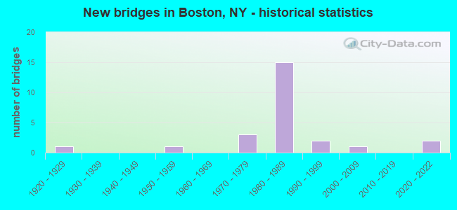
- New bridges - historical statistics
- 11920-1929
- 11950-1959
- 31970-1979
- 151980-1989
- 21990-1999
- 12000-2009
- 22020-2022

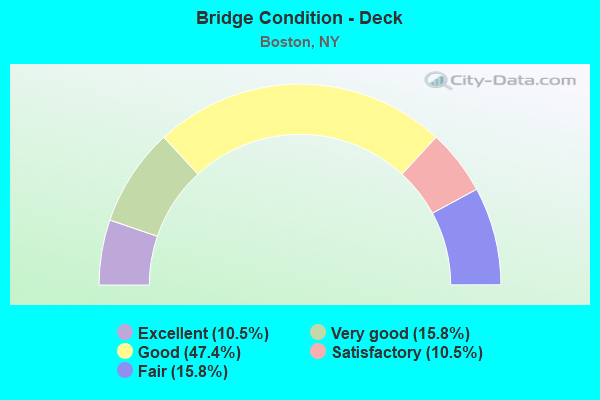
- Bridge Condition - Deck
- 10.5%Excellent
- 15.8%Very good
- 47.4%Good
- 10.5%Satisfactory
- 15.8%Fair
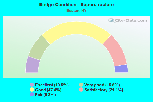
- Bridge Condition - Superstructure
- 10.5%Excellent
- 15.8%Very good
- 47.4%Good
- 21.1%Satisfactory
- 5.3%Fair
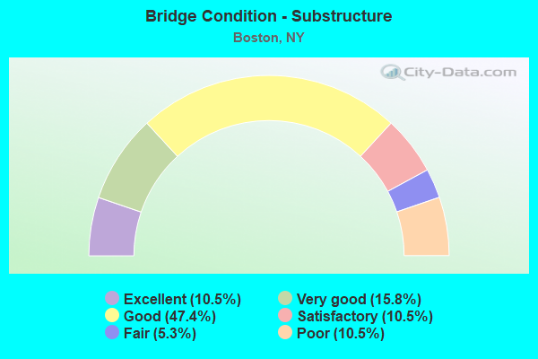
- Bridge Condition - Substructure
- 10.5%Excellent
- 15.8%Very good
- 47.4%Good
- 10.5%Satisfactory
- 5.3%Fair
- 10.5%Poor
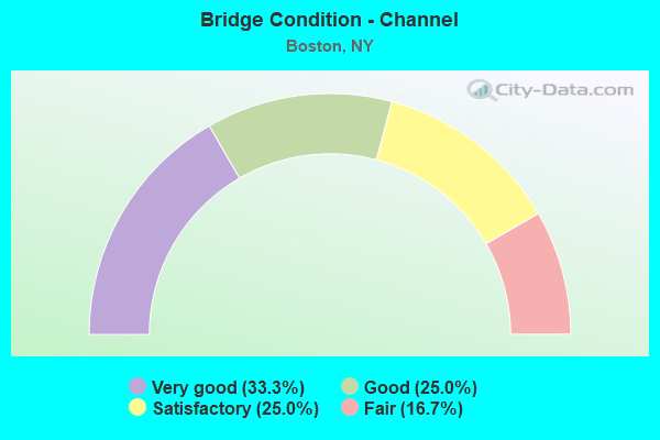
- Bridge Condition - Channel
- 33.3%Very good
- 25.0%Good
- 25.0%Satisfactory
- 16.7%Fair
Find on map >> Show street view
Structure Number: 104162, Location: 8.5 MI N JCT US219 & SH39 (Lat: 42.612517, Lng: -78.721825), Route carried "on" structure: County highway , Year Built: 1978, Status: Open, Structure Length: 1.52m (4.99ft), Average Daily Traffic: 1,328 (year 2017), Truck Traffic: 6%, Average Future Daily Traffic: 1,341 (year 2040), Design Load: HS 20, Features Intersected: LANDON BROOK, Facility Carried by Structure: BOSTON STATE ROAD
Minimum Vertical Clearance: 30+ m (98+ ft), Kilometerpoint: 0.370, Lanes on structure: 2, Owner: County Highway Agency, Approaching Roadway Width: 12.2m (40.0ft), Material/Design: Prestressed concrete, Design/Construction: Box Beam or Girders - Multiple, Number Of Spans In Main Unit: 1, Length of Maximum Span: 14.0m (45.9ft), Curb-To-Curb Width: 13.4m (44.0ft), Out-to-Out Width: 14.2m (46.6ft)
Condition: Deck: Good, Superstructure: Good, Substructure: Good, Channel: Very good, Operating Rating: 67.1 metric tons, Method Used To Determine Operating Rating: Load and Resistance Factor Rating (LRFR) rating reported by rating factor(RF) method using HL-93 loadings, Inventory Rating: 51.8 metric tons, Method Used To Determine Inventory Rating: Load and Resistance Factor Rating (LRFR) rating reported by rating factor(RF) method using HL-93 loadings, Structural Evaluation: Better than present minimum criteria, Deck Geometry: Equal to present desirable criteria, Waterway Adequacy: Equal to present minimum criteria, Approach Roadway Alignment: Equal to present desirable criteria, Length Of Structure Improvement: 1.52m (4.99ft), Designated Inspection Frequency: Every 24 months, Inspection Date: May 2020, Bridge Improvement Cost: $1,020,000, Roadway Improvement Cost: $597,000, Total Project Cost: $1,617,000 ( Estimate for 2021), Deck Structure Type: Concrete Cast-file-Place, Wearing Surface/Protective System: Wearing Surface: Bituminous, Membrane: Epoxy
Find on map >> Show street view
Structure Number: 104163, Location: 2.6 MI SE JCT SH391&SH277 (Lat: 42.659233, Lng: -78.748397), Route carried "on" structure: County highway , Year Built: 1929, Year Reconstructed: 1977, Status: Open, Structure Length: 1.10m (3.61ft), Average Daily Traffic: 4,307 (year 2018), Truck Traffic: 3%, Average Future Daily Traffic: 5,329 (year 2040), Design Load: HS 20, Features Intersected: ANTHONY GULF, Facility Carried by Structure: BOSTON STATE ROAD
Minimum Vertical Clearance: 30+ m (98+ ft), Kilometerpoint: 6.259, Lanes on structure: 2, Owner: County Highway Agency, Approaching Roadway Width: 9.1m (29.9ft), Skew: 1 degrees, Material/Design: Prestressed concrete, Design/Construction: Box Beam or Girders - Multiple, Number Of Spans In Main Unit: 1, Length of Maximum Span: 10.7m (35.1ft), Curb-To-Curb Width: 9.4m (30.8ft), Out-to-Out Width: 10.1m (33.1ft)
Condition: Deck: Satisfactory, Superstructure: Good, Substructure: Poor, Channel: Satisfactory, Operating Rating: 57.2 metric tons, Method Used To Determine Operating Rating: Load Factor (LF), Inventory Rating: 26.3 metric tons, Method Used To Determine Inventory Rating: Load Factor (LF), Structural Evaluation: Meets minimum limits, Deck Geometry: Meets minimum limits, Waterway Adequacy: Superior to present desirable criteria, Approach Roadway Alignment: Equal to present desirable criteria, Length Of Structure Improvement: 1.09m (3.58ft), Designated Inspection Frequency: Every 24 months, Inspection Date: December 2020, Bridge Improvement Cost: $649,000, Roadway Improvement Cost: $380,000, Total Project Cost: $1,029,000 ( Estimate for 2021), Deck Structure Type: Concrete Cast-file-Place, Wearing Surface/Protective System: Wearing Surface: Bituminous
Find on map >> Show street view
Structure Number: 104164, Location: 1.6 MI SE JCT SH391&SH277 (Lat: 42.669581, Lng: -78.753697), Route carried "on" structure: County highway , Year Built: 1976, Status: Open, Structure Length: 1.25m (4.10ft), Average Daily Traffic: 5,304 (year 2017), Truck Traffic: 5%, Average Future Daily Traffic: 6,562 (year 2040), Design Load: HS 20, Features Intersected: IRISH GULF, Facility Carried by Structure: BOSTON STATE ROAD
Minimum Vertical Clearance: 30+ m (98+ ft), Kilometerpoint: 7.466, Lanes on structure: 2, Owner: County Highway Agency, Approaching Roadway Width: 12.2m (40.0ft), Skew: 1 degrees, Material/Design: Prestressed concrete, Design/Construction: Box Beam or Girders - Multiple, Number Of Spans In Main Unit: 1, Length of Maximum Span: 12.2m (40.0ft), Curb-To-Curb Width: 14.6m (47.9ft), Out-to-Out Width: 15.2m (49.9ft)
Condition: Deck: Good, Superstructure: Good, Substructure: Good, Channel: Satisfactory, Operating Rating: 86.2 metric tons, Method Used To Determine Operating Rating: Load Factor (LF), Inventory Rating: 37.2 metric tons, Method Used To Determine Inventory Rating: Load Factor (LF), Structural Evaluation: Better than present minimum criteria, Deck Geometry: Superior to present desirable criteria, Waterway Adequacy: Superior to present desirable criteria, Approach Roadway Alignment: Equal to present desirable criteria, Length Of Structure Improvement: 1.24m (4.07ft), Designated Inspection Frequency: Every 24 months, Inspection Date: December 2020, Bridge Improvement Cost: $1,736,000, Roadway Improvement Cost: $1,017,000, Total Project Cost: $2,753,000 ( Estimate for 2021), Wearing Surface/Protective System: Wearing Surface: Bituminous, Membrane: Other
Find on map >> Show street view
Structure Number: 1071021, Location: JCT RTS US 219 & NY 391 (Lat: 42.694911, Lng: -78.785856), Route carried "on" structure: US 219, Year Built: 1981, Status: Open, Structure Length: 4.27m (14.01ft), Average Daily Traffic: 6,843 (year 2020), Truck Traffic: 9%, Average Future Daily Traffic: 7,929 (year 2040), Design Load: HS 20, Features Intersected: RTE 391
Minimum Vertical Clearance: 30+ m (98+ ft), Kilometerpoint: 27.063, Lanes on structure: 2, Lanes under structure: 3, Base Highway Network: Yes, Owner: State Highway Agency, Approaching Roadway Width: 12.8m (42.0ft), Skew: 3 degrees, Material/Design: Steel, Design/Construction: Stringer/Multi-beam, Number Of Spans In Main Unit: 1, Length of Maximum Span: 42.0m (137.8ft), Curb-To-Curb Width: 12.5m (41.0ft), Out-to-Out Width: 13.4m (44.0ft)
Condition: Deck: Good, Superstructure: Satisfactory, Substructure: Good, Operating Rating: 48.9 metric tons, Method Used To Determine Operating Rating: Load and Resistance Factor Rating (LRFR) rating reported by rating factor(RF) method using HL-93 loadings, Inventory Rating: 37.6 metric tons, Method Used To Determine Inventory Rating: Load and Resistance Factor Rating (LRFR) rating reported by rating factor(RF) method using HL-93 loadings, Structural Evaluation: Equal to present minimum criteria, Deck Geometry: Better than present minimum criteria, Underclear: Equal to present minimum criteria, Approach Roadway Alignment: Equal to present desirable criteria, Length Of Structure Improvement: 4.26m (13.98ft), Designated Inspection Frequency: Every 24 months, Inspection Date: June 2021, Bridge Improvement Cost: $3,062,000, Roadway Improvement Cost: $1,793,000, Total Project Cost: $4,855,000 ( Estimate for 2021), Deck Structure Type: Concrete Cast-file-Place, Wearing Surface/Protective System: Wearing Surface: Epoxy Overlay, Deck Protection: Epoxy Coated Reinforcing
Find on map >> Show street view
Structure Number: 1071022, Location: JCT RTS US 219 & NY 391 (Lat: 42.694703, Lng: -78.785506), Route carried "on" structure: US 219, Year Built: 1981, Status: Open, Structure Length: 4.24m (13.91ft), Average Daily Traffic: 6,843 (year 2020), Truck Traffic: 9%, Average Future Daily Traffic: 7,929 (year 2040), Design Load: HS 20, Features Intersected: RTE 391
Minimum Vertical Clearance: 30+ m (98+ ft), Kilometerpoint: 27.063, Lanes on structure: 2, Lanes under structure: 3, Base Highway Network: Yes, Owner: State Highway Agency, Approaching Roadway Width: 12.8m (42.0ft), Skew: 3 degrees, Material/Design: Steel, Design/Construction: Stringer/Multi-beam, Number Of Spans In Main Unit: 1, Length of Maximum Span: 41.7m (136.8ft), Curb-To-Curb Width: 12.5m (41.0ft), Out-to-Out Width: 13.4m (44.0ft)
Condition: Deck: Good, Superstructure: Satisfactory, Substructure: Good, Operating Rating: 48.0 metric tons, Method Used To Determine Operating Rating: Load and Resistance Factor Rating (LRFR) rating reported by rating factor(RF) method using HL-93 loadings, Inventory Rating: 36.9 metric tons, Method Used To Determine Inventory Rating: Load and Resistance Factor Rating (LRFR) rating reported by rating factor(RF) method using HL-93 loadings, Structural Evaluation: Equal to present minimum criteria, Deck Geometry: Better than present minimum criteria, Underclear: Equal to present minimum criteria, Approach Roadway Alignment: Equal to present desirable criteria, Length Of Structure Improvement: 4.23m (13.88ft), Designated Inspection Frequency: Every 24 months, Inspection Date: June 2021, Bridge Improvement Cost: $3,043,000, Roadway Improvement Cost: $1,782,000, Total Project Cost: $4,825,000 ( Estimate for 2021), Deck Structure Type: Concrete Cast-file-Place, Wearing Surface/Protective System: Wearing Surface: Epoxy Overlay, Deck Protection: Epoxy Coated Reinforcing
Find on map >> Show street view
Structure Number: 1071031, Location: .3 MI S JCT US219 & SH391 (Lat: 42.690664, Lng: -78.787217), Route carried "on" structure: US 219, Year Built: 1981, Status: Open, Structure Length: 4.21m (13.81ft), Average Daily Traffic: 6,633 (year 2020), Truck Traffic: 9%, Average Future Daily Traffic: 7,685 (year 2040), Design Load: HS 20, Features Intersected: EIGHTEEN MILE CRK
Minimum Vertical Clearance: 30+ m (98+ ft), Kilometerpoint: 26.597, Lanes on structure: 2, Base Highway Network: Yes, Owner: State Highway Agency, Approaching Roadway Width: 14.6m (47.9ft), Skew: 1 degrees, Material/Design: Steel, Design/Construction: Stringer/Multi-beam, Number Of Spans In Main Unit: 1, Length of Maximum Span: 41.4m (135.8ft), Curb-To-Curb Width: 13.9m (45.6ft), Out-to-Out Width: 14.8m (48.6ft)
Condition: Deck: Very good, Superstructure: Good, Substructure: Good, Channel: Good, Inventory Rating: 66.2 metric tons, Method Used To Determine Inventory Rating: Load Factor (LF), Structural Evaluation: Better than present minimum criteria, Deck Geometry: Superior to present desirable criteria, Waterway Adequacy: Equal to present desirable criteria, Approach Roadway Alignment: Equal to present desirable criteria, Length Of Structure Improvement: 4.20m (13.78ft), Designated Inspection Frequency: Every 24 months, Inspection Date: June 2021, Bridge Improvement Cost: $2,664,000, Roadway Improvement Cost: $1,560,000, Total Project Cost: $4,224,000 ( Estimate for 2021), Deck Structure Type: Concrete Cast-file-Place, Wearing Surface/Protective System: Wearing Surface: Epoxy Overlay, Deck Protection: Epoxy Coated Reinforcing
Find on map >> Show street view
Structure Number: 1071032, Location: .3 MI S JCT US219 & SH391 (Lat: 42.690569, Lng: -78.786822), Route carried "on" structure: US 219, Year Built: 1981, Status: Open, Structure Length: 4.48m (14.70ft), Average Daily Traffic: 6,633 (year 2020), Truck Traffic: 9%, Average Future Daily Traffic: 7,685 (year 2040), Design Load: HS 20, Features Intersected: EIGHTEEN MILE CRK
Minimum Vertical Clearance: 30+ m (98+ ft), Kilometerpoint: 26.597, Lanes on structure: 2, Base Highway Network: Yes, Owner: State Highway Agency, Approaching Roadway Width: 11.6m (38.1ft), Skew: 1 degrees, Material/Design: Steel, Design/Construction: Stringer/Multi-beam, Number Of Spans In Main Unit: 1, Length of Maximum Span: 43.8m (143.7ft), Curb-To-Curb Width: 12.5m (41.0ft), Out-to-Out Width: 13.4m (44.0ft)
Condition: Deck: Very good, Superstructure: Good, Substructure: Good, Channel: Fair, Operating Rating: 38.9 metric tons, Method Used To Determine Operating Rating: Load and Resistance Factor Rating (LRFR) rating reported by rating factor(RF) method using HL-93 loadings, Inventory Rating: 29.8 metric tons, Method Used To Determine Inventory Rating: Load and Resistance Factor Rating (LRFR) rating reported by rating factor(RF) method using HL-93 loadings, Structural Evaluation: Better than present minimum criteria, Deck Geometry: Better than present minimum criteria, Waterway Adequacy: Meets minimum limits, Approach Roadway Alignment: Equal to present desirable criteria, Length Of Structure Improvement: 4.48m (14.70ft), Designated Inspection Frequency: Every 24 months, Inspection Date: June 2021, Bridge Improvement Cost: $2,535,000, Roadway Improvement Cost: $1,484,000, Total Project Cost: $4,019,000 ( Estimate for 2021), Deck Structure Type: Concrete Cast-file-Place, Wearing Surface/Protective System: Wearing Surface: Epoxy Overlay, Deck Protection: Epoxy Coated Reinforcing
Find on map >> Show street view
Structure Number: 107104, Location: 1.1 MI S JCT US219&S EXPY (Lat: 42.677778, Lng: -78.783931), Route carried "on" structure: County highway , Year Built: 1981, Status: Open, Structure Length: 7.62m (25.00ft), Average Daily Traffic: 2,130 (year 2020), Truck Traffic: 5%, Average Future Daily Traffic: 2,982 (year 2040), Design Load: HS 20, Features Intersected: 219 219 53121153 SB, RTE, Facility Carried by Structure: ZIMMERMAN ROAD
Minimum Vertical Clearance: 30+ m (98+ ft), Kilometerpoint: 8.206, Lanes on structure: 2, Lanes under structure: 4, Owner: State Highway Agency, Approaching Roadway Width: 14.3m (46.9ft), Skew: 1 degrees, Material/Design: Steel continuous, Design/Construction: Stringer/Multi-beam, Number Of Spans In Main Unit: 2, Length of Maximum Span: 37.7m (123.7ft), Curb-To-Curb Width: 14.3m (46.9ft), Out-to-Out Width: 15.2m (49.9ft)
Condition: Deck: Good, Superstructure: Good, Substructure: Fair, Operating Rating: 57.7 metric tons, Method Used To Determine Operating Rating: Load and Resistance Factor Rating (LRFR) rating reported by rating factor(RF) method using HL-93 loadings, Inventory Rating: 44.4 metric tons, Method Used To Determine Inventory Rating: Load and Resistance Factor Rating (LRFR) rating reported by rating factor(RF) method using HL-93 loadings, Structural Evaluation: Somewhat better than minimum adequacy, Deck Geometry: Superior to present desirable criteria, Underclear: Somewhat better than minimum adequacy, Approach Roadway Alignment: Equal to present desirable criteria, Length Of Structure Improvement: 7.62m (25.00ft), Designated Inspection Frequency: Every 24 months, Inspection Date: June 2021, Bridge Improvement Cost: $5,087,000, Roadway Improvement Cost: $2,979,000, Total Project Cost: $8,066,000 ( Estimate for 2021), Deck Structure Type: Concrete Cast-file-Place, Wearing Surface/Protective System: Wearing Surface: Integral Concrete, Deck Protection: Epoxy Coated Reinforcing
Find on map >> Show street view
Structure Number: 107105, Location: 3.1 MI S JCT 219 & S EXPY (Lat: 42.652414, Lng: -78.766353), Route carried "on" structure: Other road , Year Built: 1981, Status: Open, Structure Length: 3.11m (10.20ft), Average Daily Traffic: 220 (year 2016), Truck Traffic: 6%, Average Future Daily Traffic: 308 (year 2036), Design Load: HS 20, Features Intersected: RTE 219, Facility Carried by Structure: SHERO ROAD
Minimum Vertical Clearance: 30+ m (98+ ft), Kilometerpoint: 0.241, Lanes on structure: 2, Lanes under structure: 2, Owner: State Highway Agency, Approaching Roadway Width: 10.4m (34.1ft), Skew: 1 degrees, Material/Design: Steel, Design/Construction: Stringer/Multi-beam, Number Of Spans In Main Unit: 1, Length of Maximum Span: 30.4m (99.7ft), Curb-To-Curb Width: 10.7m (35.1ft), Out-to-Out Width: 11.6m (38.1ft)
Condition: Deck: Fair, Superstructure: Good, Substructure: Good, Operating Rating: 49.6 metric tons, Method Used To Determine Operating Rating: Load and Resistance Factor Rating (LRFR) rating reported by rating factor(RF) method using HL-93 loadings, Inventory Rating: 38.2 metric tons, Method Used To Determine Inventory Rating: Load and Resistance Factor Rating (LRFR) rating reported by rating factor(RF) method using HL-93 loadings, Structural Evaluation: Better than present minimum criteria, Deck Geometry: Better than present minimum criteria, Underclear: Somewhat better than minimum adequacy, Approach Roadway Alignment: Equal to present desirable criteria, Length Of Structure Improvement: 3.10m (10.17ft), Designated Inspection Frequency: Every 24 months, Inspection Date: June 2021, Bridge Improvement Cost: $2,035,000, Roadway Improvement Cost: $1,192,000, Total Project Cost: $3,226,000 ( Estimate for 2021), Deck Structure Type: Concrete Cast-file-Place, Wearing Surface/Protective System: Wearing Surface: Integral Concrete, Deck Protection: Epoxy Coated Reinforcing
Find on map >> Show street view
Structure Number: 107106, Location: 4.6 MI S JCT 219 & S EXPY (Lat: 42.630772, Lng: -78.763694), Route carried "on" structure: County highway , Year Built: 1981, Status: Open, Structure Length: 8.05m (26.41ft), Average Daily Traffic: 1,542 (year 2020), Truck Traffic: 5%, Average Future Daily Traffic: 1,557 (year 2040), Design Load: HS 20, Features Intersected: 219 219 5312 1118, RTE 2, Facility Carried by Structure: RICE HILL ROAD
Minimum Vertical Clearance: 30+ m (98+ ft), Kilometerpoint: 0.402, Lanes on structure: 2, Lanes under structure: 4, Owner: State Highway Agency, Approaching Roadway Width: 19.2m (63.0ft), Material/Design: Steel continuous, Design/Construction: Stringer/Multi-beam, Number Of Spans In Main Unit: 2, Length of Maximum Span: 39.9m (130.9ft), Curb-To-Curb Width: 19.2m (63.0ft), Out-to-Out Width: 20.1m (65.9ft)
Condition: Deck: Satisfactory, Superstructure: Satisfactory, Substructure: Satisfactory, Operating Rating: 44.7 metric tons, Method Used To Determine Operating Rating: Load and Resistance Factor Rating (LRFR) rating reported by rating factor(RF) method using HL-93 loadings, Inventory Rating: 34.3 metric tons, Method Used To Determine Inventory Rating: Load and Resistance Factor Rating (LRFR) rating reported by rating factor(RF) method using HL-93 loadings, Structural Evaluation: Equal to present minimum criteria, Deck Geometry: Superior to present desirable criteria, Underclear: High priority of corrective action, Approach Roadway Alignment: Equal to present desirable criteria, Length Of Structure Improvement: 8.04m (26.38ft), Designated Inspection Frequency: Every 24 months, Inspection Date: July 2021, Bridge Improvement Cost: $6,869,000, Roadway Improvement Cost: $4,022,000, Total Project Cost: $10,891,000 ( Estimate for 2021), Deck Structure Type: Concrete Cast-file-Place, Wearing Surface/Protective System: Wearing Surface: Integral Concrete, Deck Protection: Epoxy Coated Reinforcing
Find on map >> Show street view
Structure Number: 107182, Location: 3.1 MI S JCT 219 & S EXPY (Lat: 42.652403, Lng: -78.765119), Route carried "on" structure: Other road , Year Built: 1981, Status: Open, Structure Length: 2.74m (8.99ft), Average Daily Traffic: 220 (year 2016), Truck Traffic: 6%, Average Future Daily Traffic: 308 (year 2036), Design Load: HS 20, Features Intersected: RTE 219, Facility Carried by Structure: SHERO ROAD
Minimum Vertical Clearance: 30+ m (98+ ft), Kilometerpoint: 0.354, Lanes on structure: 2, Lanes under structure: 2, Owner: State Highway Agency, Approaching Roadway Width: 10.4m (34.1ft), Skew: 1 degrees, Material/Design: Steel, Design/Construction: Stringer/Multi-beam, Number Of Spans In Main Unit: 1, Length of Maximum Span: 26.8m (87.9ft), Curb-To-Curb Width: 10.7m (35.1ft), Out-to-Out Width: 11.6m (38.1ft)
Condition: Deck: Good, Superstructure: Very good, Substructure: Good, Operating Rating: 58.6 metric tons, Method Used To Determine Operating Rating: Load and Resistance Factor Rating (LRFR) rating reported by rating factor(RF) method using HL-93 loadings, Inventory Rating: 45.4 metric tons, Method Used To Determine Inventory Rating: Load and Resistance Factor Rating (LRFR) rating reported by rating factor(RF) method using HL-93 loadings, Structural Evaluation: Better than present minimum criteria, Deck Geometry: Better than present minimum criteria, Underclear: Equal to present minimum criteria, Approach Roadway Alignment: Equal to present desirable criteria, Length Of Structure Improvement: 2.74m (8.99ft), Designated Inspection Frequency: Every 24 months, Inspection Date: June 2021, Bridge Improvement Cost: $1,899,000, Roadway Improvement Cost: $1,112,000, Total Project Cost: $3,010,000 ( Estimate for 2021), Deck Structure Type: Concrete Cast-file-Place, Wearing Surface/Protective System: Wearing Surface: Integral Concrete, Deck Protection: Epoxy Coated Reinforcing
Find on map >> Show street view
Structure Number: 332754, Location: .2 MILE WEST OF BOSTON (Lat: 42.628347, Lng: -78.741144), Route carried "on" structure: Other road , Year Built: 1953, Status: Posted for load-capacity, Structure Length: 2.13m (6.99ft), Average Daily Traffic: 663 (year 2016), Truck Traffic: 5%, Average Future Daily Traffic: 928 (year 2036), Features Intersected: EIGHTEEN MILE CRK, Facility Carried by Structure: MILL STREET
Minimum Vertical Clearance: 30+ m (98+ ft), Kilometerpoint: 0.274, Lanes on structure: 2, Owner: County Highway Agency, Approaching Roadway Width: 5.5m (18.0ft), Material/Design: Steel, Design/Construction: Stringer/Multi-beam, Number Of Spans In Main Unit: 1, Length of Maximum Span: 20.7m (67.9ft), Curb or Sidewalk Widths: Left: 0.7m (2.3ft), Right: 0.7m (2.3ft), Curb-To-Curb Width: 7.3m (24.0ft), Out-to-Out Width: 9.1m (29.9ft)
Condition: Deck: Fair, Superstructure: Fair, Substructure: Poor, Channel: Fair, Operating Rating: 40.2 metric tons, Method Used To Determine Operating Rating: Load and Resistance Factor Rating (LRFR) rating reported by rating factor(RF) method using HL-93 loadings, Inventory Rating: 30.8 metric tons, Method Used To Determine Inventory Rating: Load and Resistance Factor Rating (LRFR) rating reported by rating factor(RF) method using HL-93 loadings, Structural Evaluation: Meets minimum limits, Deck Geometry: Meets minimum limits, Waterway Adequacy: Superior to present desirable criteria, Approach Roadway Alignment: Equal to present desirable criteria, Length Of Structure Improvement: 2.13m (6.99ft), Designated Inspection Frequency: Every 24 months, Inspection Date: December 2020, Bridge Improvement Cost: $1,309,000, Roadway Improvement Cost: $767,000, Total Project Cost: $2,076,000 ( Estimate for 2021), Deck Structure Type: Concrete Cast-file-Place, Wearing Surface/Protective System: Wearing Surface: Bituminous
Find on map >> Show street view
Structure Number: 33276, Location: .1 MILE SW OF BOSTON (Lat: 42.684711, Lng: -78.777917), Route carried "on" structure: County highway , Year Built: 1987, Status: Open, Structure Length: 2.38m (7.81ft), Average Daily Traffic: 3,553 (year 2016), Truck Traffic: 8%, Average Future Daily Traffic: 4,974 (year 2036), Design Load: HS 20+Mod, Features Intersected: EIGHTEEN MILE CRK, Facility Carried by Structure: ZIMMERMAN ROAD
Minimum Vertical Clearance: 30+ m (98+ ft), Kilometerpoint: 9.123, Lanes on structure: 2, Owner: County Highway Agency, Approaching Roadway Width: 12.5m (41.0ft), Skew: 3 degrees, Material/Design: Steel, Design/Construction: Stringer/Multi-beam, Number Of Spans In Main Unit: 1, Length of Maximum Span: 22.2m (72.8ft), Curb-To-Curb Width: 11.9m (39.0ft), Out-to-Out Width: 12.5m (41.0ft)
Condition: Deck: Good, Superstructure: Good, Substructure: Good, Channel: Good, Inventory Rating: 67.1 metric tons, Method Used To Determine Inventory Rating: Load Factor (LF), Structural Evaluation: Better than present minimum criteria, Deck Geometry: Somewhat better than minimum adequacy, Waterway Adequacy: Better than present minimum criteria, Approach Roadway Alignment: Equal to present desirable criteria, Length Of Structure Improvement: 2.37m (7.78ft), Designated Inspection Frequency: Every 24 months, Inspection Date: May 2020, Bridge Improvement Cost: $2,342,000, Roadway Improvement Cost: $1,372,000, Total Project Cost: $3,714,000 ( Estimate for 2021), Deck Structure Type: Concrete Cast-file-Place, Wearing Surface/Protective System: Wearing Surface: Integral Concrete, Deck Protection: Epoxy Coated Reinforcing
Find on map >> Show street view
Structure Number: 332761, Location: .4 MILE WEST OF PATCHIN (Lat: 42.657903, Lng: -78.755006), Route carried "on" structure: Other road , Year Built: 1991, Status: Open, Structure Length: 2.35m (7.71ft), Average Daily Traffic: 697 (year 2016), Truck Traffic: 5%, Average Future Daily Traffic: 976 (year 2036), Design Load: HS 20, Features Intersected: EIGHTEEN MILE CRK, Facility Carried by Structure: PATCHIN ROAD
Minimum Vertical Clearance: 30+ m (98+ ft), Kilometerpoint: 0.064, Lanes on structure: 2, Owner: County Highway Agency, Approaching Roadway Width: 8.5m (27.9ft), Skew: 2 degrees, Material/Design: Prestressed concrete, Design/Construction: Box Beam or Girders - Multiple, Number Of Spans In Main Unit: 1, Length of Maximum Span: 22.8m (74.8ft), Curb-To-Curb Width: 8.5m (27.9ft), Out-to-Out Width: 9.5m (31.2ft)
Condition: Deck: Good, Superstructure: Very good, Substructure: Very good, Channel: Good, Operating Rating: 82.6 metric tons, Method Used To Determine Operating Rating: Load Factor (LF), Inventory Rating: 39.9 metric tons, Method Used To Determine Inventory Rating: Load Factor (LF), Structural Evaluation: Equal to present desirable criteria, Deck Geometry: Somewhat better than minimum adequacy, Waterway Adequacy: Equal to present desirable criteria, Approach Roadway Alignment: Equal to present desirable criteria, Length Of Structure Improvement: 2.34m (7.68ft), Designated Inspection Frequency: Every 24 months, Inspection Date: April 2020, Bridge Improvement Cost: $822,000, Roadway Improvement Cost: $481,000, Total Project Cost: $1,303,000 ( Estimate for 2021), Deck Structure Type: Concrete Cast-file-Place, Wearing Surface/Protective System: Wearing Surface: Integral Concrete
Find on map >> Show street view
Structure Number: 332775, Location: 1 MILE NW OF BOSTON (Lat: 42.696108, Lng: -78.791178), Route carried "on" structure: County highway , Year Built: 2003, Status: Open, Structure Length: 2.50m (8.20ft), Average Daily Traffic: 2,556 (year 2017), Truck Traffic: 6%, Average Future Daily Traffic: 3,162 (year 2040), Design Load: HS 25 or greater, Features Intersected: BR EIGHTEEN MI CK, Facility Carried by Structure: ECKHARDT ROAD
Minimum Vertical Clearance: 30+ m (98+ ft), Kilometerpoint: 5.905, Lanes on structure: 2, Owner: County Highway Agency, Approaching Roadway Width: 9.1m (29.9ft), Material/Design: Prestressed concrete, Design/Construction: Box Beam or Girders - Multiple, Number Of Spans In Main Unit: 1, Length of Maximum Span: 24.0m (78.7ft), Curb-To-Curb Width: 9.1m (29.9ft), Out-to-Out Width: 10.1m (33.1ft)
Condition: Deck: Very good, Superstructure: Very good, Substructure: Very good, Channel: Satisfactory, Operating Rating: 84.9 metric tons, Method Used To Determine Operating Rating: Load and Resistance Factor Rating (LRFR) rating reported by rating factor(RF) method using HL-93 loadings, Inventory Rating: 40.8 metric tons, Method Used To Determine Inventory Rating: Load and Resistance Factor Rating (LRFR) rating reported by rating factor(RF) method using HL-93 loadings, Structural Evaluation: Equal to present desirable criteria, Deck Geometry: Meets minimum limits, Waterway Adequacy: Somewhat better than minimum adequacy, Approach Roadway Alignment: Equal to present desirable criteria, Length Of Structure Improvement: 2.49m (8.17ft), Designated Inspection Frequency: Every 24 months, Inspection Date: October 2021, Bridge Improvement Cost: $878,000, Roadway Improvement Cost: $514,000, Total Project Cost: $1,393,000 ( Estimate for 2021), Deck Structure Type: Concrete Cast-file-Place, Wearing Surface/Protective System: Wearing Surface: Integral Concrete, Deck Protection: Galvanized Reinforcing
Find on map >> Show street view
Structure Number: 332784, Location: 0.9 MI. N. OF BOSTON (Lat: 42.644511, Lng: -78.744000), Route carried "on" structure: County highway , Year Built: 2020, Status: Open, Structure Length: 3.08m (10.10ft), Average Daily Traffic: 357 (year 2015), Truck Traffic: 4%, Average Future Daily Traffic: 500 (year 2035), Design Load: HL 93, Features Intersected: EIGHTEEN MILE CRK, Facility Carried by Structure: HILLCROFT DR.
Minimum Vertical Clearance: 30+ m (98+ ft), Kilometerpoint: 0.161, Lanes on structure: 2, Owner: County Highway Agency, Approaching Roadway Width: 7.9m (25.9ft), Material/Design: Steel, Design/Construction: Stringer/Multi-beam, Number Of Spans In Main Unit: 1, Length of Maximum Span: 30.2m (99.1ft), Curb-To-Curb Width: 7.9m (25.9ft), Out-to-Out Width: 8.9m (29.2ft)
Condition: Deck: Excellent, Superstructure: Excellent, Substructure: Excellent, Channel: Very good, Operating Rating: 96.2 metric tons, Method Used To Determine Operating Rating: Load Factor (LF), Inventory Rating: 58.1 metric tons, Method Used To Determine Inventory Rating: Load Factor (LF), Structural Evaluation: Superior to present desirable criteria, Deck Geometry: Somewhat better than minimum adequacy, Waterway Adequacy: Better than present minimum criteria, Approach Roadway Alignment: Equal to present desirable criteria, Length Of Structure Improvement: 3.07m (10.07ft), Designated Inspection Frequency: Every 24 months, Inspection Date: November 2020, Bridge Improvement Cost: $884,000, Roadway Improvement Cost: $518,000, Total Project Cost: $1,402,000 ( Estimate for 2021), Deck Structure Type: Concrete Cast-file-Place, Wearing Surface/Protective System: Wearing Surface: Integral Concrete, Deck Protection: Galvanized Reinforcing
Find on map >> Show street view
Structure Number: 332856, Location: .8 MILE SE OF BOSTON (Lat: 42.618900, Lng: -78.730283), Route carried "on" structure: County highway , Year Built: 2020, Status: Open, Structure Length: 2.53m (8.30ft), Average Daily Traffic: 736 (year 2017), Truck Traffic: 9%, Average Future Daily Traffic: 1,030 (year 2037), Design Load: HL 93, Features Intersected: EIGHTEEN MILE CREEK, Facility Carried by Structure: TREVETT ROAD
Minimum Vertical Clearance: 32.69m (107.25ft), Kilometerpoint: 16.203, Lanes on structure: 2, Owner: County Highway Agency, Approaching Roadway Width: 9.8m (32.2ft), Skew: 3 degrees, Material/Design: Steel, Design/Construction: Stringer/Multi-beam, Number Of Spans In Main Unit: 1, Length of Maximum Span: 24.1m (79.1ft), Curb-To-Curb Width: 9.8m (32.2ft), Out-to-Out Width: 10.8m (35.4ft)
Condition: Deck: Excellent, Superstructure: Excellent, Substructure: Excellent, Channel: Very good, Operating Rating: 69.3 metric tons, Method Used To Determine Operating Rating: Load and Resistance Factor Rating (LRFR) rating reported by rating factor(RF) method using HL-93 loadings, Inventory Rating: 53.5 metric tons, Method Used To Determine Inventory Rating: Load and Resistance Factor Rating (LRFR) rating reported by rating factor(RF) method using HL-93 loadings, Structural Evaluation: Superior to present desirable criteria, Deck Geometry: Equal to present minimum criteria, Waterway Adequacy: Better than present minimum criteria, Approach Roadway Alignment: Equal to present minimum criteria, Length Of Structure Improvement: 2.52m (8.27ft), Designated Inspection Frequency: Every 24 months, Inspection Date: November 2020, Bridge Improvement Cost: $1,558,000, Roadway Improvement Cost: $912,000, Total Project Cost: $2,470,000 ( Estimate for 2021), Deck Structure Type: Concrete Cast-file-Place, Wearing Surface/Protective System: Wearing Surface: Integral Concrete, Deck Protection: Galvanized Reinforcing
Find on map >> Show street view
Structure Number: 336844, Location: 5.2 MI S JCT SH277 &SH391 (Lat: 42.622592, Lng: -78.734489), Route carried "on" structure: County highway , Year Built: 1994, Status: Open, Structure Length: 3.75m (12.30ft), Average Daily Traffic: 678 (year 2020), Truck Traffic: 6%, Average Future Daily Traffic: 838 (year 2040), Design Load: HS 20, Features Intersected: EIGHTEEN MILE CRK, Facility Carried by Structure: WEST TILLEN ROAD
Minimum Vertical Clearance: 30+ m (98+ ft), Kilometerpoint: 3.492, Lanes on structure: 2, Owner: County Highway Agency, Approaching Roadway Width: 10.4m (34.1ft), Skew: 1 degrees, Material/Design: Steel, Design/Construction: Stringer/Multi-beam, Number Of Spans In Main Unit: 1, Length of Maximum Span: 37.1m (121.7ft), Curb-To-Curb Width: 10.4m (34.1ft), Out-to-Out Width: 11.0m (36.1ft)
Condition: Deck: Fair, Superstructure: Good, Substructure: Very good, Channel: Very good, Operating Rating: 68.9 metric tons, Method Used To Determine Operating Rating: Load Factor (LF), Inventory Rating: 33.6 metric tons, Method Used To Determine Inventory Rating: Load Factor (LF), Structural Evaluation: Better than present minimum criteria, Deck Geometry: Equal to present minimum criteria, Waterway Adequacy: Equal to present desirable criteria, Approach Roadway Alignment: Equal to present desirable criteria, Length Of Structure Improvement: 3.74m (12.27ft), Designated Inspection Frequency: Every 24 months, Inspection Date: May 2020, Bridge Improvement Cost: $1,544,000, Roadway Improvement Cost: $904,000, Total Project Cost: $2,449,000 ( Estimate for 2021), Deck Structure Type: Concrete Cast-file-Place, Wearing Surface/Protective System: Wearing Surface: Integral Concrete, Deck Protection: Epoxy Coated Reinforcing
Find on map >> Show street view
Structure Number: 5006131, Location: JCT SMRP&RTE 9A HAWTHORNE (Lat: 41.108067, Lng: -73.806383), Route carried "on" structure: Other road 987D, Year Built: 1972, Status: Open, Structure Length: 8.75m (28.71ft), Average Daily Traffic: 21,932 (year 2007), Truck Traffic: 1%, Average Future Daily Traffic: 30,939 (year 2040), Design Load: HS 20, Features Intersected: 9A 9A87032103 SB, RTE 9
Minimum Vertical Clearance: 30+ m (98+ ft), Kilometerpoint: 24.956, Lanes on structure: 3, Lanes under structure: 5, Base Highway Network: Yes, Owner: State Highway Agency, Approaching Roadway Width: 14.6m (47.9ft), Skew: 4 degrees, Material/Design: Steel, Design/Construction: Stringer/Multi-beam, Number Of Spans In Main Unit: 4, Length of Maximum Span: 26.2m (86.0ft), Curb-To-Curb Width: 14.6m (47.9ft), Out-to-Out Width: 17.2m (56.4ft)
Condition: Deck: Good, Superstructure: Satisfactory, Substructure: Satisfactory, Operating Rating: 73.2 metric tons, Method Used To Determine Operating Rating: Load and Resistance Factor Rating (LRFR) rating reported by rating factor(RF) method using HL-93 loadings, Inventory Rating: 56.4 metric tons, Method Used To Determine Inventory Rating: Load and Resistance Factor Rating (LRFR) rating reported by rating factor(RF) method using HL-93 loadings, Structural Evaluation: Equal to present minimum criteria, Deck Geometry: Meets minimum limits, Underclear: Meets minimum limits, Approach Roadway Alignment: Equal to present desirable criteria, Length Of Structure Improvement: 8.74m (28.67ft), Designated Inspection Frequency: Every 24 months, Inspection Date: June 2020, Bridge Improvement Cost: $5,732,000, Roadway Improvement Cost: $3,357,000, Total Project Cost: $9,088,000 ( Estimate for 2021), Deck Structure Type: Concrete Cast-file-Place, Wearing Surface/Protective System: Wearing Surface: Latex Concrete
Find on map >> Show street view
Structure Number: 1071021, Location: JCT RTS US 219 & NY 391 (Lat: 42.694911, Lng: -78.785856), Route carried "under" structure: State highway 391, Year Built: 1981, Structure Length: 0. m, Average Daily Traffic: 10,855 (year 2002), Features Intersected: RTE 391, Facility Carried by Structure: RTE 219
Minimum Vertical Clearance: 4.67m (15.32ft), Kilometerpoint: 1.271, Lanes on structure: 2, Lanes under structure: 3, Material/Design: Steel, Design/Construction: Stringer/Multi-beam, Length of Maximum Span: 42.0m (137.8ft)
Find on map >> Show street view
Structure Number: 1071022, Location: JCT RTS US 219 & NY 391 (Lat: 42.694703, Lng: -78.785506), Route carried "under" structure: State highway 391, Year Built: 1981, Structure Length: 0. m, Average Daily Traffic: 10,855 (year 2002), Features Intersected: RTE 391, Facility Carried by Structure: RTE 219
Minimum Vertical Clearance: 4.54m (14.90ft), Kilometerpoint: 1.271, Lanes on structure: 2, Lanes under structure: 3, Material/Design: Steel, Design/Construction: Stringer/Multi-beam, Length of Maximum Span: 41.7m (136.8ft)
Find on map >> Show street view
Structure Number: 107104, Location: 1.1 MI S JCT US219&S EXPY (Lat: 42.677778, Lng: -78.783931), Route carried "under" structure: US 219, Year Built: 1981, Structure Length: 0. m, Average Daily Traffic: 13,733 (year 2002), Features Intersected: 219 219 53121153 SB, RTE, Facility Carried by Structure: ZIMMERMAN ROAD
Minimum Vertical Clearance: 4.95m (16.24ft), Kilometerpoint: 25.261, Lanes on structure: 2, Lanes under structure: 2, Material/Design: Steel continuous, Design/Construction: Stringer/Multi-beam, Length of Maximum Span: 37.7m (123.7ft)
Find on map >> Show street view
Structure Number: 107105, Location: 3.1 MI S JCT 219 & S EXPY (Lat: 42.652414, Lng: -78.766353), Route carried "under" structure: US 219, Year Built: 1981, Structure Length: 0. m, Average Daily Traffic: 13,733 (year 2002), Features Intersected: RTE 219, Facility Carried by Structure: SHERO ROAD
Minimum Vertical Clearance: 5.11m (16.77ft), Kilometerpoint: 21.979, Lanes on structure: 2, Lanes under structure: 2, Material/Design: Steel, Design/Construction: Stringer/Multi-beam, Length of Maximum Span: 30.4m (99.7ft)
Find on map >> Show street view
Structure Number: 107106, Location: 4.6 MI S JCT 219 & S EXPY (Lat: 42.630772, Lng: -78.763694), Route carried "under" structure: Interstate 219, Year Built: 1981, Structure Length: 0. m, Average Daily Traffic: 12,078 (year 2002), Features Intersected: 219 219 5312 1118, RTE 2, Facility Carried by Structure: RICE HILL ROAD
Minimum Vertical Clearance: 4.80m (15.75ft), Kilometerpoint: 19.533, Lanes on structure: 2, Lanes under structure: 2, Material/Design: Steel continuous, Design/Construction: Stringer/Multi-beam, Length of Maximum Span: 39.9m (130.9ft)
Find on map >> Show street view
Structure Number: 107182, Location: 3.1 MI S JCT 219 & S EXPY (Lat: 42.652403, Lng: -78.765119), Route carried "under" structure: US 219, Year Built: 1981, Structure Length: 0. m, Average Daily Traffic: 3,250 (year 1986), Features Intersected: RTE 219, Facility Carried by Structure: SHERO ROAD
Minimum Vertical Clearance: 4.85m (15.91ft), Kilometerpoint: 0.000, Lanes on structure: 2, Lanes under structure: 2, Material/Design: Steel, Design/Construction: Stringer/Multi-beam, Length of Maximum Span: 26.8m (87.9ft)