Bridge Statistics for Bremerton, Washington (WA)
Condition, Traffic, Stress, Structural Evaluation, Project Costs
- National Bridge Inventory (NBI) Statistics
- 27Number of bridges
- 627ft / 191mTotal length
- $98,909,000Total costs
- 540,814Total average daily traffic
- 30,411Total average daily truck traffic
- National Bridge Inventory (NBI) Registered Bridges for Bremerton
- No street view available for this location
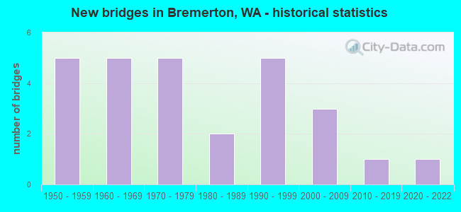
- New bridges - historical statistics
- 51950-1959
- 51960-1969
- 51970-1979
- 21980-1989
- 51990-1999
- 32000-2009
- 12010-2019
- 12020-2022
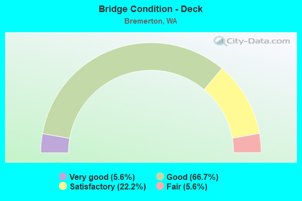
- Bridge Condition - Deck
- 5.6%Very good
- 66.7%Good
- 22.2%Satisfactory
- 5.6%Fair
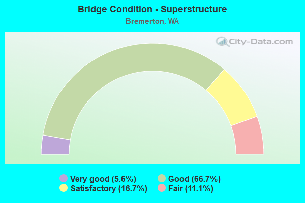
- Bridge Condition - Superstructure
- 5.6%Very good
- 66.7%Good
- 16.7%Satisfactory
- 11.1%Fair
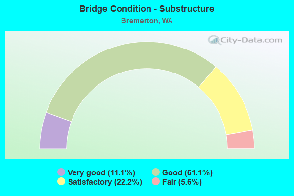
- Bridge Condition - Substructure
- 11.1%Very good
- 61.1%Good
- 22.2%Satisfactory
- 5.6%Fair
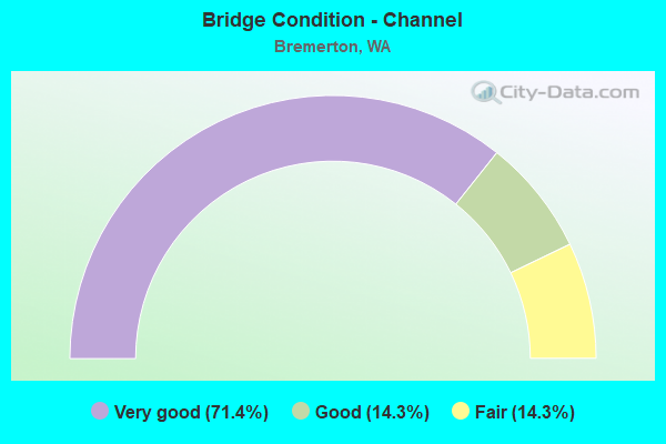
- Bridge Condition - Channel
- 71.4%Very good
- 14.3%Good
- 14.3%Fair
Find on map >> Show street view
Structure Number: 1WA015, Location: 620 M SE OF NEVADA ST. E (Lat: 47.567592, Lng: -122.551703), Route carried "on" structure: ServiceFederal lands road , Year Built: 1954, Status: Posted for load, Structure Length: 3.63m (11.91ft), Average Daily Traffic: 20 (year 2016), Truck Traffic: 2%, Average Future Daily Traffic: 24 (year 2037), Design Load: H 15, Features Intersected: PATROL RD. & BEACH DRIVE, Facility Carried by Structure: FUEL STORAGE FACIL
Minimum Vertical Clearance: 30+ m (98+ ft), Kilometerpoint: 0.000, Lanes on structure: 1, Lanes under structure: 3, Owner: Navy/Marines, Approaching Roadway Width: 4.1m (13.5ft), Material/Design: Steel, Design/Construction: Stringer/Multi-beam, Number Of Spans In Main Unit: 3, Number Of Approach Spans: 2, Length of Maximum Span: 13.1m (43.0ft), Curb-To-Curb Width: 3.7m (12.1ft), Out-to-Out Width: 4.1m (13.5ft)
Condition: Deck: Satisfactory, Superstructure: Good, Substructure: Satisfactory, Operating Rating: 34.0 metric tons, Method Used To Determine Operating Rating: Load Factor (LF), Inventory Rating: 20.3 metric tons, Method Used To Determine Inventory Rating: Load Factor (LF), Structural Evaluation: Somewhat better than minimum adequacy, Deck Geometry: Meets minimum limits, Underclear: Meets minimum limits, Approach Roadway Alignment: Equal to present desirable criteria, Length Of Structure Improvement: 1.00m (3.28ft), Designated Inspection Frequency: Every 24 months, Critical Feature Inspection Frequency: Every 24 months, Inspection Date: August 2020, Critical Feature Inspection Date: August 2020, Bridge Improvement Cost: $18,000, Roadway Improvement Cost: $42,000, Total Project Cost: $60,000 ( Estimate for 2020), Deck Structure Type: Concrete Cast-file-Place, Wearing Surface/Protective System: Wearing Surface: Monolithic Concrete
Find on map >> Show street view
Structure Number: 5237A, Location: 9.8 N PIERCE CO (Lat: 47.528167, Lng: -122.677500), Route carried "on" structure: State highway 16, Year Built: 1956, Status: Open, Structure Length: 7.13m (23.39ft), Average Daily Traffic: 29,125 (year 2019), Truck Traffic: 5%, Average Future Daily Traffic: 38,678 (year 2039), Design Load: HS 20, Features Intersected: SR 166
Minimum Vertical Clearance: 30+ m (98+ ft), Kilometerpoint: 44.756, Lanes on structure: 2, Lanes under structure: 2, Base Highway Network: Yes, Owner: State Highway Agency, Approaching Roadway Width: 11.6m (38.1ft), Material/Design: Concrete continuous, Design/Construction: Box Beam or Girders - Multiple, Number Of Spans In Main Unit: 3, Length of Maximum Span: 25.9m (85.0ft), Curb-To-Curb Width: 8.5m (27.9ft), Out-to-Out Width: 10.3m (33.8ft)
Condition: Deck: Satisfactory, Superstructure: Satisfactory, Substructure: Good, Operating Rating: 49.9 metric tons, Method Used To Determine Operating Rating: Load and Resistance Factor Rating (LRFR) rating reported by rating factor(RF) method using HL-93 loadings, Inventory Rating: 38.6 metric tons, Method Used To Determine Inventory Rating: Load and Resistance Factor Rating (LRFR) rating reported by rating factor(RF) method using HL-93 loadings, Structural Evaluation: Equal to present minimum criteria, Deck Geometry: High priority of corrective action, Underclear: Somewhat better than minimum adequacy, Approach Roadway Alignment: Equal to present desirable criteria, Length Of Structure Improvement: 7.13m (23.39ft), Designated Inspection Frequency: Every 24 months, Inspection Date: August 2021, Bridge Improvement Cost: $1,872,000, Roadway Improvement Cost: $374,000, Total Project Cost: $3,744,000 ( Estimate for 2014), Deck Structure Type: Concrete Cast-file-Place, Wearing Surface/Protective System: Wearing Surface: Latex Concrete
Find on map >> Show street view
Structure Number: 5565A, Location: 0.7 N JCT SR 304 (Lat: 47.578061, Lng: -122.632731), Route carried "on" structure: State highway 303, Year Built: 1958, Status: Open, Structure Length: 52.33m (171.69ft), Average Daily Traffic: 43,552 (year 2019), Truck Traffic: 3%, Average Future Daily Traffic: 57,837 (year 2039), Design Load: HS 20, Features Intersected: PORT WASHINGTON NARROWS
Minimum Vertical Clearance: 30+ m (98+ ft), Kilometerpoint: 1.175, Lanes on structure: 4, Lanes under structure: 2, Base Highway Network: Yes, Owner: State Highway Agency, Approaching Roadway Width: 16.5m (54.1ft), Skew: 30 degrees, Navigation Control: Yes ( Vertical Clearance: 24.4m (80.1ft), Horizontal Clearance: 70.4m (231.0ft)), Material/Design: Steel continuous, Design/Construction: Girder and Floorbeam System, Number Of Spans In Main Unit: 3, Number Of Approach Spans: 12, Length of Maximum Span: 76.2m (250.0ft), Curb or Sidewalk Widths: Left: 1.2m (3.9ft), Right: 1.2m (3.9ft), Curb-To-Curb Width: 16.5m (54.1ft), Out-to-Out Width: 20.6m (67.6ft)
Condition: Deck: Fair, Superstructure: Fair, Substructure: Satisfactory, Channel: Very good, Operating Rating: 38.1 metric tons, Method Used To Determine Operating Rating: Load Factor (LF), Inventory Rating: 22.7 metric tons, Method Used To Determine Inventory Rating: Load Factor (LF), Structural Evaluation: Somewhat better than minimum adequacy, Deck Geometry: Meets minimum limits, Underclear: Meets minimum limits, Waterway Adequacy: Equal to present desirable criteria, Approach Roadway Alignment: Equal to present desirable criteria, Length Of Structure Improvement: 52.33m (171.69ft), Designated Inspection Frequency: Every 24 months, Critical Feature Inspection Frequency: Every 24 months, Underwater Inspection Frequency: Every 60 months, Inspection Date: October 2020, Critical Feature Inspection Date: October 2020, Underwater Inspection Date: October 2020, Bridge Improvement Cost: $19,230,000, Roadway Improvement Cost: $3,846,000, Total Project Cost: $38,461,000 ( Estimate for 2014), Deck Structure Type: Concrete Cast-file-Place, Wearing Surface/Protective System: Wearing Surface: Epoxy Overlay
Find on map >> Show street view
Structure Number: 5770A, Location: 1.3 N JCT SR 304 (Lat: 47.585556, Lng: -122.630000), Route carried "on" structure: State highway 303, Year Built: 1958, Status: Open, Structure Length: 1.16m (3.81ft), Average Daily Traffic: 40,981 (year 2019), Truck Traffic: 3%, Average Future Daily Traffic: 54,422 (year 2039), Design Load: HS 20, Features Intersected: CALLAHAN DRIVE
Minimum Vertical Clearance: 30+ m (98+ ft), Kilometerpoint: 2.028, Lanes on structure: 4, Lanes under structure: 1, Base Highway Network: Yes, Owner: State Highway Agency, Approaching Roadway Width: 17.1m (56.1ft), Skew: 3 degrees, Material/Design: Concrete, Design/Construction: Slab, Number Of Spans In Main Unit: 1, Length of Maximum Span: 9.4m (30.8ft), Curb or Sidewalk Widths: Left: 1.4m (4.6ft), Right: 1.4m (4.6ft), Curb-To-Curb Width: 17.1m (56.1ft), Out-to-Out Width: 20.3m (66.6ft)
Condition: Deck: Good, Superstructure: Good, Substructure: Good, Operating Rating: 73.5 metric tons, Method Used To Determine Operating Rating: Load Factor (LF), Inventory Rating: 43.5 metric tons, Method Used To Determine Inventory Rating: Load Factor (LF), Structural Evaluation: Better than present minimum criteria, Deck Geometry: Somewhat better than minimum adequacy, Underclear: Meets minimum limits, Approach Roadway Alignment: Equal to present desirable criteria, Length Of Structure Improvement: 1.16m (3.81ft), Designated Inspection Frequency: Every 48 months, Inspection Date: July 2019, Bridge Improvement Cost: $441,000, Roadway Improvement Cost: $88,000, Total Project Cost: $882,000 ( Estimate for 2014), Deck Structure Type: Concrete Cast-file-Place, Wearing Surface/Protective System: Wearing Surface: Bituminous
Find on map >> Show street view
Structure Number: 6825A, Location: 0.4 E JCT SR 303 (Lat: 47.562150, Lng: -122.624817), Route carried "on" structure: State highway 304, Year Built: 1961, Year Reconstructed: 1997, Status: Open, Structure Length: 3.20m (10.50ft), Average Daily Traffic: 560 (year 2010), Average Future Daily Traffic: 953 (year 2037), Design Load: HS 20+Mod, Features Intersected: SINCLAIR INLET
Minimum Vertical Clearance: 4.88m (16.01ft), Kilometerpoint: 5.649, Lanes on structure: 2, Base Highway Network: Yes, Toll: Toll bridge, Owner: State Highway Agency, Approaching Roadway Width: 6.7m (22.0ft), Material/Design: Steel, Design/Construction: Truss - Thru, Number Of Spans In Main Unit: 1, Length of Maximum Span: 27.4m (89.9ft), Curb or Sidewalk Widths: Left: 0.2m (0.7ft), Right: 0.2m (0.7ft), Curb-To-Curb Width: 5.9m (19.4ft), Out-to-Out Width: 6.5m (21.3ft)
Condition: Deck: Good, Superstructure: Satisfactory, Substructure: Satisfactory, Channel: Very good, Operating Rating: 36.3 metric tons, Method Used To Determine Operating Rating: Load Factor (LF), Inventory Rating: 21.8 metric tons, Method Used To Determine Inventory Rating: Load Factor (LF), Structural Evaluation: Somewhat better than minimum adequacy, Deck Geometry: High priority of replacement, Waterway Adequacy: Equal to present desirable criteria, Approach Roadway Alignment: Equal to present desirable criteria, Length Of Structure Improvement: 3.20m (10.50ft), Designated Inspection Frequency: Every 24 months, Critical Feature Inspection Frequency: Every 24 months, Underwater Inspection Frequency: Every 60 months, Other Special Inspection Frequency: Every 24 months, Inspection Date: May 2021, Critical Feature Inspection Date: May 2021, Underwater Inspection Date: April 2021, Other Special Inspection Date: May 2021, Bridge Improvement Cost: $504,000, Roadway Improvement Cost: $101,000, Total Project Cost: $1,008,000 ( Estimate for 2014), Deck Structure Type: Wood or Timber, Wearing Surface/Protective System: Wearing Surface: Bituminous, Membrane: Preformed Fabric
Find on map >> Show street view
Structure Number: 7883A, Location: 4.5 N JCT SR 304 (Lat: 47.581944, Lng: -122.695000), Route carried "on" structure: City street , Year Built: 1966, Status: Open, Structure Length: 7.68m (25.20ft), Average Daily Traffic: 5,602 (year 2012), Truck Traffic: 5%, Average Future Daily Traffic: 8,829 (year 2036), Design Load: HS 20, Features Intersected: SR 3, Facility Carried by Structure: AUSTIN DRIVE
Minimum Vertical Clearance: 30+ m (98+ ft), Kilometerpoint: 0.064, Lanes on structure: 2, Lanes under structure: 4, Owner: State Highway Agency, Approaching Roadway Width: 10.4m (34.1ft), Skew: 2 degrees, Material/Design: Concrete continuous, Design/Construction: Box Beam or Girders - Multiple, Number Of Spans In Main Unit: 4, Length of Maximum Span: 21.6m (70.9ft), Curb or Sidewalk Widths: Left: 0.9m (3.0ft), Right: 0.9m (3.0ft), Curb-To-Curb Width: 7.9m (25.9ft), Out-to-Out Width: 10.2m (33.5ft)
Condition: Deck: Good, Superstructure: Good, Substructure: Good, Operating Rating: 45.7 metric tons, Method Used To Determine Operating Rating: Load and Resistance Factor Rating (LRFR) rating reported by rating factor(RF) method using HL-93 loadings, Inventory Rating: 35.0 metric tons, Method Used To Determine Inventory Rating: Load and Resistance Factor Rating (LRFR) rating reported by rating factor(RF) method using HL-93 loadings, Structural Evaluation: Better than present minimum criteria, Deck Geometry: High priority of corrective action, Underclear: Equal to present minimum criteria, Approach Roadway Alignment: Equal to present minimum criteria, Length Of Structure Improvement: 7.68m (25.20ft), Designated Inspection Frequency: Every 48 months, Inspection Date: April 2018, Bridge Improvement Cost: $1,814,000, Roadway Improvement Cost: $363,000, Total Project Cost: $3,629,000 ( Estimate for 2014), Deck Structure Type: Concrete Cast-file-Place, Wearing Surface/Protective System: Wearing Surface: Latex Concrete
Find on map >> Show street view
Structure Number: 7883B, Location: 5.6 N JCT SR 304 (Lat: 47.596486, Lng: -122.698839), Route carried "on" structure: State highway 3, Year Built: 1966, Status: Open, Structure Length: 4.88m (16.01ft), Average Daily Traffic: 30,482 (year 2019), Truck Traffic: 7%, Average Future Daily Traffic: 40,480 (year 2039), Design Load: HS 20, Features Intersected: ERLAND POINT RD
Minimum Vertical Clearance: 30+ m (98+ ft), Kilometerpoint: 65.082, Lanes on structure: 2, Lanes under structure: 2, Base Highway Network: Yes, Owner: State Highway Agency, Approaching Roadway Width: 12.2m (40.0ft), Material/Design: Prestressed concrete continuous, Design/Construction: Stringer/Multi-beam, Number Of Spans In Main Unit: 3, Length of Maximum Span: 17.1m (56.1ft), Curb or Sidewalk Widths: Left: 0.5m (1.6ft), Right: 0.5m (1.6ft), Curb-To-Curb Width: 9.1m (29.9ft), Out-to-Out Width: 10.7m (35.1ft)
Condition: Deck: Good, Superstructure: Good, Substructure: Good, Operating Rating: 53.5 metric tons, Method Used To Determine Operating Rating: Load Factor (LF), Inventory Rating: 32.7 metric tons, Method Used To Determine Inventory Rating: Load Factor (LF), Structural Evaluation: Better than present minimum criteria, Deck Geometry: High priority of replacement, Underclear: Equal to present desirable criteria, Approach Roadway Alignment: Equal to present desirable criteria, Length Of Structure Improvement: 4.88m (16.01ft), Designated Inspection Frequency: Every 24 months, Inspection Date: April 2021, Bridge Improvement Cost: $1,344,000, Roadway Improvement Cost: $269,000, Total Project Cost: $2,688,000 ( Estimate for 2014), Deck Structure Type: Concrete Cast-file-Place, Wearing Surface/Protective System: Wearing Surface: Latex Concrete
Find on map >> Show street view
Structure Number: 9203A, Location: 0.7 N JCT SR 304 (Lat: 47.558019, Lng: -122.672389), Route carried "on" structure: City street , Year Built: 1972, Status: Open, Structure Length: 6.49m (21.29ft), Average Daily Traffic: 13,643 (year 2012), Truck Traffic: 1%, Average Future Daily Traffic: 21,501 (year 2036), Design Load: HS 20+Mod, Features Intersected: SR 3, Facility Carried by Structure: WERNER/LOXIE EAGAN
Minimum Vertical Clearance: 30+ m (98+ ft), Kilometerpoint: 0.113, Lanes on structure: 4, Lanes under structure: 4, Owner: State Highway Agency, Approaching Roadway Width: 14.6m (47.9ft), Skew: 2 degrees, Material/Design: Prestressed concrete continuous, Design/Construction: Stringer/Multi-beam, Number Of Spans In Main Unit: 2, Length of Maximum Span: 32.0m (105.0ft), Curb or Sidewalk Widths: Left: 1.5m (4.9ft), Right: 1.5m (4.9ft), Curb-To-Curb Width: 14.6m (47.9ft), Out-to-Out Width: 18.5m (60.7ft)
Condition: Deck: Good, Superstructure: Good, Substructure: Good, Operating Rating: 89.8 metric tons, Method Used To Determine Operating Rating: Load Factor (LF), Inventory Rating: 68.0 metric tons, Method Used To Determine Inventory Rating: Load Factor (LF), Structural Evaluation: Better than present minimum criteria, Deck Geometry: High priority of replacement, Underclear: Somewhat better than minimum adequacy, Approach Roadway Alignment: Equal to present desirable criteria, Length Of Structure Improvement: 6.49m (21.29ft), Designated Inspection Frequency: Every 24 months, Inspection Date: April 2021, Bridge Improvement Cost: $2,130,000, Roadway Improvement Cost: $426,000, Total Project Cost: $4,260,000 ( Estimate for 2014), Deck Structure Type: Concrete Cast-file-Place, Wearing Surface/Protective System: Wearing Surface: Monolithic Concrete
Find on map >> Show street view
Structure Number: 9476B, Location: 3.5 N JCT SR 304 (Lat: 47.569306, Lng: -122.684306), Route carried "on" structure: State highway 3, Year Built: 1974, Status: Open, Structure Length: 6.37m (20.90ft), Average Daily Traffic: 22,888 (year 2019), Truck Traffic: 7%, Average Future Daily Traffic: 30,395 (year 2039), Design Load: HS 20+Mod, Features Intersected: SR 310/KITSAP WAY
Minimum Vertical Clearance: 30+ m (98+ ft), Kilometerpoint: 61.622, Lanes on structure: 2, Lanes under structure: 5, Base Highway Network: Yes, Owner: State Highway Agency, Approaching Roadway Width: 14.0m (45.9ft), Skew: 1 degrees, Material/Design: Prestressed concrete continuous, Design/Construction: Stringer/Multi-beam, Number Of Spans In Main Unit: 3, Length of Maximum Span: 32.0m (105.0ft), Curb-To-Curb Width: 13.2m (43.3ft), Out-to-Out Width: 14.1m (46.3ft)
Condition: Deck: Good, Superstructure: Good, Substructure: Good, Operating Rating: 73.5 metric tons, Method Used To Determine Operating Rating: Load Factor (LF), Inventory Rating: 43.5 metric tons, Method Used To Determine Inventory Rating: Load Factor (LF), Structural Evaluation: Better than present minimum criteria, Deck Geometry: Somewhat better than minimum adequacy, Underclear: Somewhat better than minimum adequacy, Approach Roadway Alignment: Equal to present desirable criteria, Length Of Structure Improvement: 6.37m (20.90ft), Designated Inspection Frequency: Every 24 months, Inspection Date: April 2021, Bridge Improvement Cost: $2,006,000, Roadway Improvement Cost: $401,000, Total Project Cost: $4,013,000 ( Estimate for 2014), Deck Structure Type: Concrete Cast-file-Place, Wearing Surface/Protective System: Wearing Surface: Bituminous, Membrane: Preformed Fabric
Find on map >> Show street view
Structure Number: 12352A, Location: 3.5 N JCT SR 304 (Lat: 47.569306, Lng: -122.684083), Route carried "on" structure: State highway 3, Year Built: 1983, Status: Open, Structure Length: 6.40m (21.00ft), Average Daily Traffic: 22,888 (year 2019), Truck Traffic: 7%, Average Future Daily Traffic: 30,395 (year 2039), Design Load: HS 20+Mod, Features Intersected: SR 310/KITSAP WAY
Minimum Vertical Clearance: 30+ m (98+ ft), Kilometerpoint: 61.622, Lanes on structure: 2, Lanes under structure: 5, Base Highway Network: Yes, Owner: State Highway Agency, Approaching Roadway Width: 14.0m (45.9ft), Skew: 1 degrees, Material/Design: Prestressed concrete continuous, Design/Construction: Stringer/Multi-beam, Number Of Spans In Main Unit: 3, Length of Maximum Span: 32.3m (106.0ft), Curb-To-Curb Width: 13.2m (43.3ft), Out-to-Out Width: 14.1m (46.3ft)
Condition: Deck: Good, Superstructure: Satisfactory, Substructure: Good, Operating Rating: 79.8 metric tons, Method Used To Determine Operating Rating: Load Factor (LF), Inventory Rating: 48.1 metric tons, Method Used To Determine Inventory Rating: Load Factor (LF), Structural Evaluation: Equal to present minimum criteria, Deck Geometry: Superior to present desirable criteria, Underclear: Somewhat better than minimum adequacy, Approach Roadway Alignment: Equal to present desirable criteria, Length Of Structure Improvement: 6.40m (21.00ft), Designated Inspection Frequency: Every 24 months, Inspection Date: April 2021, Bridge Improvement Cost: $2,016,000, Roadway Improvement Cost: $403,000, Total Project Cost: $4,032,000 ( Estimate for 2014), Deck Structure Type: Concrete Cast-file-Place, Wearing Surface/Protective System: Wearing Surface: Monolithic Concrete, Deck Protection: Epoxy Coated Reinforcing
Find on map >> Show street view
Structure Number: 13652A, Location: JCT SR 3 (Lat: 47.548194, Lng: -122.671250), Route carried "on" structure: State highway 304, Year Built: 1991, Status: Open, Structure Length: 9.72m (31.89ft), Average Daily Traffic: 14,407 (year 2019), Truck Traffic: 3%, Average Future Daily Traffic: 19,132 (year 2039), Design Load: HS 20+Mod, Features Intersected: SR 3
Minimum Vertical Clearance: 30+ m (98+ ft), Kilometerpoint: 0.001, Lanes on structure: 2, Lanes under structure: 3, Base Highway Network: Yes, Owner: State Highway Agency, Approaching Roadway Width: 12.2m (40.0ft), Material/Design: Prestressed concrete continuous, Design/Construction: Box Beam or Girders - Multiple, Number Of Spans In Main Unit: 2, Length of Maximum Span: 50.6m (166.0ft), Curb-To-Curb Width: 11.6m (38.1ft), Out-to-Out Width: 12.7m (41.7ft)
Condition: Deck: Good, Superstructure: Good, Substructure: Good, Operating Rating: 89.8 metric tons, Method Used To Determine Operating Rating: Load Factor (LF), Inventory Rating: 50.8 metric tons, Method Used To Determine Inventory Rating: Load Factor (LF), Structural Evaluation: Better than present minimum criteria, Deck Geometry: Better than present minimum criteria, Underclear: Meets minimum limits, Approach Roadway Alignment: Equal to present minimum criteria, Length Of Structure Improvement: 9.72m (31.89ft), Designated Inspection Frequency: Every 24 months, Inspection Date: Febuary 2022, Bridge Improvement Cost: $3,182,000, Roadway Improvement Cost: $636,000, Total Project Cost: $6,364,000 ( Estimate for 2022), Deck Structure Type: Concrete Cast-file-Place, Wearing Surface/Protective System: Wearing Surface: Monolithic Concrete, Deck Protection: Epoxy Coated Reinforcing
Find on map >> Show street view
Structure Number: 13663A, Location: 0.4 E JCT SR 303 (Lat: 47.562033, Lng: -122.625167), Route carried "on" structure: State highway 304, Year Built: 1990, Status: Open, Structure Length: 3.20m (10.50ft), Average Daily Traffic: 3,600 (year 2010), Truck Traffic: 1%, Average Future Daily Traffic: 4,320 (year 2031), Design Load: HS 20, Features Intersected: SINCLAIR INLET
Minimum Vertical Clearance: 4.88m (16.01ft), Kilometerpoint: 5.649, Lanes on structure: 2, Base Highway Network: Yes, Toll: Toll bridge, Owner: State Highway Agency, Approaching Roadway Width: 7.3m (24.0ft), Material/Design: Steel, Design/Construction: Movable - Lift, Number Of Spans In Main Unit: 1, Length of Maximum Span: 24.4m (80.1ft), Curb or Sidewalk Widths: Left: 0.5m (1.6ft), Right: 0.5m (1.6ft), Curb-To-Curb Width: 6.1m (20.0ft), Out-to-Out Width: 7.6m (24.9ft)
Condition: Deck: Satisfactory, Superstructure: Good, Substructure: Satisfactory, Channel: Very good, Operating Rating: 41.7 metric tons, Method Used To Determine Operating Rating: Load Factor (LF), Inventory Rating: 25.4 metric tons, Method Used To Determine Inventory Rating: Load Factor (LF), Structural Evaluation: Equal to present minimum criteria, Deck Geometry: High priority of replacement, Waterway Adequacy: Equal to present desirable criteria, Approach Roadway Alignment: Equal to present desirable criteria, Length Of Structure Improvement: 3.20m (10.50ft), Designated Inspection Frequency: Every 24 months, Critical Feature Inspection Frequency: Every 24 months, Underwater Inspection Frequency: Every 60 months, Other Special Inspection Frequency: Every 24 months, Inspection Date: May 2021, Critical Feature Inspection Date: May 2021, Underwater Inspection Date: April 2021, Other Special Inspection Date: May 2021, Bridge Improvement Cost: $546,000, Roadway Improvement Cost: $109,000, Total Project Cost: $1,092,000 ( Estimate for 2014), Deck Structure Type: Closed Grating, Wearing Surface/Protective System: Wearing Surface: Bituminous
Find on map >> Show street view
Structure Number: 13663B, Location: 0.4 E JCT SR 303 (Lat: 47.562028, Lng: -122.625000), Route carried "on" structure: State highway 304, Year Built: 1990, Status: Open, Structure Length: 6.25m (20.51ft), Average Daily Traffic: 12,807 (year 2010), Average Future Daily Traffic: 15,368 (year 2032), Design Load: HS 20+Mod, Features Intersected: SINCLAIR INLET
Minimum Vertical Clearance: 30+ m (98+ ft), Kilometerpoint: 5.649, Lanes on structure: 2, Base Highway Network: Yes, Toll: Toll bridge, Owner: State Highway Agency, Approaching Roadway Width: 6.7m (22.0ft), Skew: 2 degrees, Material/Design: Concrete, Design/Construction: Slab, Number Of Spans In Main Unit: 4, Length of Maximum Span: 6.7m (22.0ft), Curb or Sidewalk Widths: Left: 0.3m (1.0ft), Right: 0.3m (1.0ft), Curb-To-Curb Width: 6.7m (22.0ft), Out-to-Out Width: 7.7m (25.3ft)
Condition: Deck: Good, Superstructure: Good, Substructure: Good, Channel: Very good, Operating Rating: 22.7 metric tons, Method Used To Determine Operating Rating: Load Factor (LF), Inventory Rating: 13.6 metric tons, Method Used To Determine Inventory Rating: Load Factor (LF), Structural Evaluation: High priority of corrective action, Deck Geometry: High priority of replacement, Waterway Adequacy: Equal to present desirable criteria, Approach Roadway Alignment: Equal to present desirable criteria, Length Of Structure Improvement: 6.25m (20.51ft), Designated Inspection Frequency: Every 24 months, Underwater Inspection Frequency: Every 60 months, Inspection Date: May 2021, Underwater Inspection Date: April 2021, Bridge Improvement Cost: $984,000, Roadway Improvement Cost: $197,000, Total Project Cost: $1,968,000 ( Estimate for 2014), Deck Structure Type: Concrete Precast Panels, Wearing Surface/Protective System: Wearing Surface: Bituminous, Deck Protection: Epoxy Coated Reinforcing
Find on map >> Show street view
Structure Number: 17926A, Location: 0.6 E JCT SR 303 (Lat: 47.569297, Lng: -122.623267), Route carried "on" structure: City street 303, Year Built: 2011, Status: Open, Structure Length: 47.24m (154.99ft), Average Daily Traffic: 6,537 (year 2011), Truck Traffic: 3%, Average Future Daily Traffic: 10,949 (year 2036), Design Load: HL 93, Features Intersected: PORT WASH NARROWS, Facility Carried by Structure: CITY STREET
Minimum Vertical Clearance: 30+ m (98+ ft), Kilometerpoint: 0.483, Lanes on structure: 2, Base Highway Network: Yes, Owner: State Highway Agency, Approaching Roadway Width: 9.1m (29.9ft), Navigation Control: Yes ( Vertical Clearance: 22.9m (75.1ft), Horizontal Clearance: 70.4m (231.0ft)), Material/Design: Prestressed concrete continuous, Design/Construction: Stringer/Multi-beam, Number Of Spans In Main Unit: 7, Length of Maximum Span: 76.2m (250.0ft), Curb or Sidewalk Widths: Left: 0.0m, Right: 3.2m (10.5ft), Curb-To-Curb Width: 9.1m (29.9ft), Out-to-Out Width: 16.7m (54.8ft)
Condition: Deck: Good, Superstructure: Good, Substructure: Very good, Channel: Good, Operating Rating: 46.7 metric tons, Method Used To Determine Operating Rating: Load and Resistance Factor Rating (LRFR) rating reported by rating factor(RF) method using HL-93 loadings, Inventory Rating: 36.0 metric tons, Method Used To Determine Inventory Rating: Load and Resistance Factor Rating (LRFR) rating reported by rating factor(RF) method using HL-93 loadings, Structural Evaluation: Better than present minimum criteria, Deck Geometry: Meets minimum limits, Waterway Adequacy: Equal to present desirable criteria, Approach Roadway Alignment: Equal to present desirable criteria, Length Of Structure Improvement: 47.24m (154.99ft), Designated Inspection Frequency: Every 24 months, Underwater Inspection Frequency: Every 60 months, Inspection Date: December 2021, Underwater Inspection Date: May 2017, Bridge Improvement Cost: $9,920,000, Roadway Improvement Cost: $1,984,000, Total Project Cost: $19,840,000 ( Estimate for 2014), Deck Structure Type: Concrete Cast-file-Place, Wearing Surface/Protective System: Wearing Surface: Monolithic Concrete, Deck Protection: Epoxy Coated Reinforcing
Find on map >> Show street view
Structure Number: 85224, Location: 00.10 MI E JCT SR 3 (Lat: 47.571861, Lng: -122.655028), Route carried "on" structure: City street 2152, Year Built: 1963, Status: Open, Structure Length: 1.95m (6.40ft), Average Daily Traffic: 19,840 (year 2017), Truck Traffic: 8%, Average Future Daily Traffic: 21,700 (year 2040), Design Load: HS 20, Features Intersected: WYCOFF AVENUE, Facility Carried by Structure: 11TH STREET
Minimum Vertical Clearance: 30+ m (98+ ft), Kilometerpoint: 0.161, Lanes on structure: 4, Lanes under structure: 2, Base Highway Network: Yes, Owner: City or Municipal Highway Agency, Approaching Roadway Width: 21.3m (69.9ft), Skew: 1 degrees, Material/Design: Prestressed concrete, Design/Construction: Stringer/Multi-beam, Number Of Spans In Main Unit: 1, Length of Maximum Span: 17.1m (56.1ft), Curb or Sidewalk Widths: Left: 1.6m (5.2ft), Right: 1.7m (5.6ft), Curb-To-Curb Width: 15.6m (51.2ft), Out-to-Out Width: 19.6m (64.3ft)
Condition: Deck: Satisfactory, Superstructure: Fair, Substructure: Fair, Operating Rating: 39.9 metric tons, Method Used To Determine Operating Rating: Load Factor (LF) rating reported by rating factor (RF) method using MS18 loading, Inventory Rating: 24.0 metric tons, Method Used To Determine Inventory Rating: Load Factor (LF) rating reported by rating factor (RF) method using MS18 loading, Structural Evaluation: Somewhat better than minimum adequacy, Deck Geometry: Meets minimum limits, Underclear: Superior to present desirable criteria, Approach Roadway Alignment: Equal to present minimum criteria, Length Of Structure Improvement: 1.95m (6.40ft), Designated Inspection Frequency: Every 24 months, Inspection Date: November 2021, Bridge Improvement Cost: $922,000, Roadway Improvement Cost: $184,000, Total Project Cost: $1,843,000 ( Estimate for 2014), Deck Structure Type: Concrete Cast-file-Place, Wearing Surface/Protective System: Wearing Surface: Bituminous
Find on map >> Show street view
Structure Number: 85949, Location: 0.14 E JCT MINARD RD W (Lat: 47.510897, Lng: -122.792086), Route carried "on" structure: County highway 10609, Year Built: 1992, Status: Open, Structure Length: 1.43m (4.69ft), Average Daily Traffic: 3,789 (year 2020), Truck Traffic: 13%, Average Future Daily Traffic: 4,168 (year 2042), Design Load: HS 20, Features Intersected: UNION RIVER, Facility Carried by Structure: W BELFAIR VALY RD
Minimum Vertical Clearance: 30+ m (98+ ft), Kilometerpoint: 0.001, Lanes on structure: 2, Owner: County Highway Agency, Approaching Roadway Width: 9.8m (32.2ft), Material/Design: Prestressed concrete, Design/Construction: Slab, Number Of Spans In Main Unit: 1, Length of Maximum Span: 13.4m (44.0ft), Curb-To-Curb Width: 12.5m (41.0ft), Out-to-Out Width: 13.4m (44.0ft)
Condition: Deck: Good, Superstructure: Good, Substructure: Good, Channel: Fair, Operating Rating: 72.6 metric tons, Method Used To Determine Operating Rating: Load Factor (LF) rating reported by rating factor (RF) method using MS18 loading, Inventory Rating: 43.4 metric tons, Method Used To Determine Inventory Rating: Load Factor (LF) rating reported by rating factor (RF) method using MS18 loading, Structural Evaluation: Better than present minimum criteria, Deck Geometry: Equal to present minimum criteria, Waterway Adequacy: Better than present minimum criteria, Approach Roadway Alignment: Equal to present desirable criteria, Length Of Structure Improvement: 1.43m (4.69ft), Designated Inspection Frequency: Every 24 months, Inspection Date: June 2021, Bridge Improvement Cost: $320,000, Roadway Improvement Cost: $64,000, Total Project Cost: $639,000 ( Estimate for 2014), Deck Structure Type: Concrete Precast Panels, Wearing Surface/Protective System: Wearing Surface: Bituminous, Membrane: Other, Deck Protection: Epoxy Coated Reinforcing
Find on map >> Show street view
Structure Number: 89167, Location: 2.6 MI SE OF SR 3 (Lat: 47.464250, Lng: -122.745008), Route carried "on" structure: County highway 25009, Year Built: 2020, Status: Open, Structure Length: 2.47m (8.10ft), Average Daily Traffic: 4,545 (year 2020), Truck Traffic: 21%, Average Future Daily Traffic: 5,000 (year 2040), Design Load: HL 93, Features Intersected: COUTLER CREEK, Facility Carried by Structure: SW LAKE FLORA ROAD
Minimum Vertical Clearance: 30+ m (98+ ft), Kilometerpoint: 0.001, Lanes on structure: 2, Owner: County Highway Agency, Approaching Roadway Width: 12.2m (40.0ft), Skew: 1 degrees, Material/Design: Prestressed concrete, Design/Construction: Stringer/Multi-beam, Number Of Spans In Main Unit: 1, Length of Maximum Span: 21.9m (71.9ft), Curb-To-Curb Width: 12.2m (40.0ft), Out-to-Out Width: 12.9m (42.3ft)
Condition: Deck: Very good, Superstructure: Very good, Substructure: Very good, Channel: Very good, Operating Rating: 70.6 metric tons, Method Used To Determine Operating Rating: Load and Resistance Factor Rating (LRFR) rating reported by rating factor(RF) method using HL-93 loadings, Inventory Rating: 46.7 metric tons, Method Used To Determine Inventory Rating: Load and Resistance Factor Rating (LRFR) rating reported by rating factor(RF) method using HL-93 loadings, Structural Evaluation: Equal to present desirable criteria, Deck Geometry: Equal to present minimum criteria, Waterway Adequacy: Equal to present desirable criteria, Approach Roadway Alignment: Equal to present desirable criteria, Designated Inspection Frequency: Every 24 months, Inspection Date: October 2020, Deck Structure Type: Concrete Cast-file-Place, Wearing Surface/Protective System: Wearing Surface: Monolithic Concrete, Deck Protection: Epoxy Coated Reinforcing
Find on map >> Show street view
Structure Number: GA1206A, Location: 0.8 E JCT SR 303 (Lat: 47.562800, Lng: -122.625050), Route carried "on" structure: ServiceOther road 304, Year Built: 2000, Status: Posted for load, Structure Length: 19.66m (64.50ft), Average Daily Traffic: 22 (year 2012), Average Future Daily Traffic: 28 (year 2036), Design Load: HS 20+Mod, Features Intersected: SR 304, WSF QUEUE LANES
Minimum Vertical Clearance: 30+ m (98+ ft), Kilometerpoint: 0.001, Lanes on structure: 1, Lanes under structure: 16, Owner: State Highway Agency, Maintenance Responsibility: Local Toll Authority, Approaching Roadway Width: 4.6m (15.1ft), Material/Design: Prestressed concrete continuous, Design/Construction: Slab, Number Of Spans In Main Unit: 23, Length of Maximum Span: 12.2m (40.0ft), Curb or Sidewalk Widths: Left: 0.0m, Right: 2.4m (7.9ft), Curb-To-Curb Width: 4.6m (15.1ft), Out-to-Out Width: 36.0m (118.1ft)
Condition: Deck: Good, Superstructure: Good, Substructure: Good, Operating Rating: 21.8 metric tons, Method Used To Determine Operating Rating: Load Factor (LF), Inventory Rating: 12.7 metric tons, Method Used To Determine Inventory Rating: Load Factor (LF), Structural Evaluation: Meets minimum limits, Deck Geometry: Better than present minimum criteria, Underclear: High priority of corrective action, Approach Roadway Alignment: Equal to present desirable criteria, Length Of Structure Improvement: 19.66m (64.50ft), Designated Inspection Frequency: Every 24 months, Inspection Date: May 2021, Bridge Improvement Cost: $2,193,000, Roadway Improvement Cost: $439,000, Total Project Cost: $4,386,000 ( Estimate for 2014), Deck Structure Type: Other, Wearing Surface/Protective System: Wearing Surface: Monolithic Concrete, Deck Protection: Epoxy Coated Reinforcing
Find on map >> Show street view
Structure Number: 5237A, Location: 0.3 E JCT SR 16 (Lat: 47.528167, Lng: -122.677500), Route carried "under" structure: State highway 166, Year Built: 1956, Structure Length: 0. m, Average Daily Traffic: 14,639 (year 2019), Truck Traffic: 3%, Features Intersected: SR 166, Facility Carried by Structure: SR 16 NORTHBOUND
Minimum Vertical Clearance: 5.79m (19.00ft), Kilometerpoint: 0.563, Lanes on structure: 2, Lanes under structure: 2, Material/Design: Concrete continuous, Design/Construction: Box Beam or Girders - Multiple, Length of Maximum Span: 25.9m (85.0ft)
Find on map >> Show street view
Structure Number: 7883A, Location: 4.5 N JCT SR 304 (Lat: 47.581944, Lng: -122.695000), Route carried "under" structure: State highway 3, Year Built: 1966, Structure Length: 0. m, Average Daily Traffic: 57,697 (year 2019), Truck Traffic: 7%, Features Intersected: SR 3, Facility Carried by Structure: AUSTIN DRIVE
Minimum Vertical Clearance: 5.89m (19.32ft), Kilometerpoint: 63.279, Lanes on structure: 2, Lanes under structure: 4, Material/Design: Concrete continuous, Design/Construction: Box Beam or Girders - Multiple, Length of Maximum Span: 21.6m (70.9ft)
Find on map >> Show street view
Structure Number: 9203A, Location: 0.7 N JCT SR 304 (Lat: 47.558019, Lng: -122.672389), Route carried "under" structure: State highway 3, Year Built: 1972, Structure Length: 0. m, Average Daily Traffic: 41,787 (year 2019), Truck Traffic: 7%, Features Intersected: SR 3, Facility Carried by Structure: WERNER/LOXIE EAGAN
Minimum Vertical Clearance: 5.69m (18.67ft), Kilometerpoint: 60.045, Lanes on structure: 4, Lanes under structure: 4, Material/Design: Prestressed concrete continuous, Design/Construction: Stringer/Multi-beam, Length of Maximum Span: 32.0m (105.0ft)
Find on map >> Show street view
Structure Number: 9476A, Location: 1.2 N JCT SR 304 (Lat: 47.564056, Lng: -122.678000), Route carried "under" structure: State highway 3, Year Built: 1974, Structure Length: 0. m, Average Daily Traffic: 50,930 (year 2019), Truck Traffic: 7%, Features Intersected: SR 3, Facility Carried by Structure: SEARLE ST PED
Minimum Vertical Clearance: 5.51m (18.08ft), Kilometerpoint: 60.865, Lanes under structure: 5, Material/Design: Prestressed concrete continuous, Design/Construction: Tee Beam, Length of Maximum Span: 39.6m (129.9ft)
Find on map >> Show street view
Structure Number: 9476B, Location: JCT SR 3 (Lat: 47.569306, Lng: -122.684306), Route carried "under" structure: State highway 310, Year Built: 1974, Structure Length: 0. m, Average Daily Traffic: 23,730 (year 2019), Truck Traffic: 5%, Features Intersected: SR 310/KITSAP WAY, Facility Carried by Structure: SR 3
Minimum Vertical Clearance: 5.59m (18.34ft), Kilometerpoint: 0.001, Lanes on structure: 2, Lanes under structure: 5, Material/Design: Prestressed concrete continuous, Design/Construction: Stringer/Multi-beam, Length of Maximum Span: 32.0m (105.0ft)
Find on map >> Show street view
Structure Number: 12352A, Location: JCT SR 3 (Lat: 47.569306, Lng: -122.684083), Route carried "under" structure: State highway 310, Year Built: 1983, Structure Length: 0. m, Average Daily Traffic: 23,730 (year 2019), Truck Traffic: 5%, Features Intersected: SR 310/KITSAP WAY, Facility Carried by Structure: SR 3
Minimum Vertical Clearance: 5.26m (17.26ft), Kilometerpoint: 0.016, Lanes on structure: 2, Lanes under structure: 5, Material/Design: Prestressed concrete continuous, Design/Construction: Stringer/Multi-beam, Length of Maximum Span: 32.3m (106.0ft)
Find on map >> Show street view
Structure Number: 13652A, Location: 2.1 N JCT SR 16 (Lat: 47.548194, Lng: -122.671250), Route carried "under" structure: State highway 3, Year Built: 1991, Structure Length: 0. m, Average Daily Traffic: 49,773 (year 2019), Truck Traffic: 7%, Features Intersected: SR 3
Minimum Vertical Clearance: 6.48m (21.26ft), Kilometerpoint: 58.886, Lanes on structure: 2, Lanes under structure: 3, Material/Design: Prestressed concrete continuous, Design/Construction: Box Beam or Girders - Multiple, Length of Maximum Span: 50.6m (166.0ft)
Find on map >> Show street view
Structure Number: GA1206A, Location: 0.8 E JCT SR 303 (Lat: 47.562800, Lng: -122.625050), Route carried "under" structure: State highway 304, Year Built: 2000, Structure Length: 0. m, Average Daily Traffic: 1,810 (year 2008), Truck Traffic: 5%, Features Intersected: SR 304, WSF QUEUE LANES
Minimum Vertical Clearance: 5.31m (17.42ft), Kilometerpoint: 5.617, Lanes on structure: 1, Lanes under structure: 16, Material/Design: Prestressed concrete continuous, Design/Construction: Slab, Length of Maximum Span: 12.2m (40.0ft)
Find on map >> Show street view
Structure Number: GA1206B, Location: 0.8 E JCT SR 303 (Lat: 47.562483, Lng: -122.624733), Route carried "under" structure: State highway 304, Year Built: 2000, Structure Length: 0. m, Average Daily Traffic: 1,430 (year 2010), Truck Traffic: 4%, Features Intersected: SR 304, Facility Carried by Structure: TERMINAL BUILDING
Minimum Vertical Clearance: 4.72m (15.49ft), Kilometerpoint: 5.601, Lanes under structure: 2, Material/Design: Steel, Design/Construction: Stringer/Multi-beam, Length of Maximum Span: 65.5m (214.9ft)