Bridge Statistics for Bridgeport, Ohio (OH)
Condition, Traffic, Stress, Structural Evaluation, Project Costs
- National Bridge Inventory (NBI) Statistics
- 14Number of bridges
- 751ft / 229mTotal length
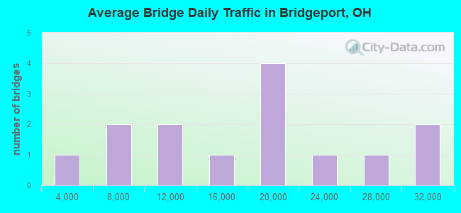
- 219,619Total average daily traffic
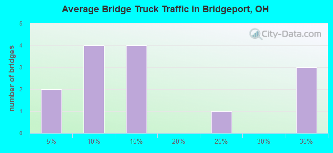
- 33,167Total average daily truck traffic
- National Bridge Inventory (NBI) Registered Bridges for Bridgeport
- No street view available for this location
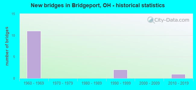
- New bridges - historical statistics
- 111960-1969
- 21990-1999
- 12010-2019
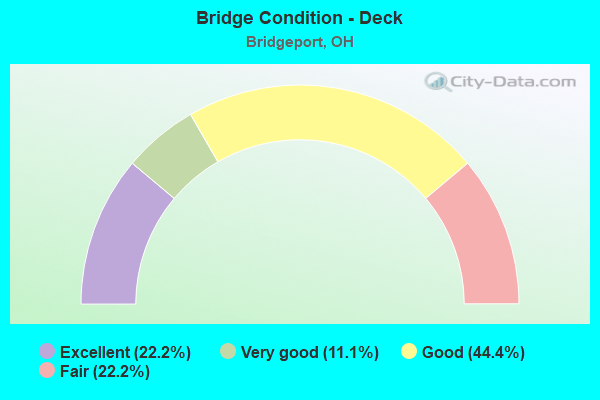
- Bridge Condition - Deck
- 22.2%Excellent
- 11.1%Very good
- 44.4%Good
- 22.2%Fair
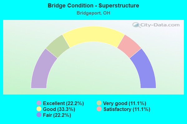
- Bridge Condition - Superstructure
- 22.2%Excellent
- 11.1%Very good
- 33.3%Good
- 11.1%Satisfactory
- 22.2%Fair
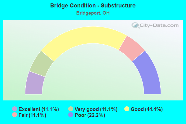
- Bridge Condition - Substructure
- 11.1%Excellent
- 11.1%Very good
- 44.4%Good
- 11.1%Fair
- 22.2%Poor
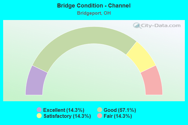
- Bridge Condition - Channel
- 14.3%Excellent
- 57.1%Good
- 14.3%Satisfactory
- 14.3%Fair
Find on map >> Show street view
Structure Number: 700541, Location: .9 M E OF BRIDGEPORT (Lat: 40.069431, Lng: -80.740500), Route carried "on" structure: State highway 7, Year Built: 1968, Status: Open, Structure Length: 49.76m (163.25ft), Average Daily Traffic: 24,467 (year 2015), Truck Traffic: 11%, Average Future Daily Traffic: 33,960 (year 2035), Design Load: HS 20, Features Intersected: US40SR767I70SUB-CREEK&RR
Minimum Vertical Clearance: 4.72m (15.49ft), Kilometerpoint: 31.785, Lanes on structure: 4, Lanes under structure: 4, Base Highway Network: Yes (, Subroute: 1), Owner: State Highway Agency, Approaching Roadway Width: 17.7m (58.1ft), Skew: 10 degrees, Material/Design: Steel continuous, Design/Construction: Stringer/Multi-beam, Number Of Spans In Main Unit: 21, Length of Maximum Span: 35.1m (115.2ft), Curb-To-Curb Width: 17.7m (58.1ft), Out-to-Out Width: 21.5m (70.5ft)
Condition: Deck: Good, Superstructure: Satisfactory, Substructure: Fair, Channel: Fair, Operating Rating: 42.1 metric tons, Method Used To Determine Operating Rating: Load Factor (LF) rating reported by rating factor (RF) method using MS18 loading, Inventory Rating: 32.4 metric tons, Method Used To Determine Inventory Rating: Load Factor (LF) rating reported by rating factor (RF) method using MS18 loading, Structural Evaluation: Somewhat better than minimum adequacy, Deck Geometry: Meets minimum limits, Underclear: High priority of corrective action, Waterway Adequacy: Equal to present desirable criteria, Approach Roadway Alignment: Equal to present desirable criteria, Designated Inspection Frequency: Every 12 months, Inspection Date: August 2021, Deck Structure Type: Concrete Cast-file-Place, Wearing Surface/Protective System: Wearing Surface: Integral Concrete
Find on map >> Show street view
Structure Number: 701823, Location: BRIDGEPORT, @ OH ST LINE (Lat: 40.072319, Lng: -80.738689), Route carried "on" structure: US 40, Year Built: 1998, Status: Open, Structure Length: 19.61m (64.34ft), Average Daily Traffic: 17,100 (year 2018), Truck Traffic: 11%, Average Future Daily Traffic: 20,862 (year 2038), Design Load: HS 25 or greater, Features Intersected: OHIO R. BACKCHANNEL
Minimum Vertical Clearance: 30+ m (98+ ft), Kilometerpoint: 45.834, Lanes on structure: 3, Owner: State Highway Agency, Approaching Roadway Width: 16.5m (54.1ft), Material/Design: Steel, Design/Construction: Girder and Floorbeam System, Number Of Spans In Main Unit: 1, Number Of Approach Spans: 2, Length of Maximum Span: 79.2m (259.8ft), Curb or Sidewalk Widths: Left: 1.5m (4.9ft), Right: 1.5m (4.9ft), Curb-To-Curb Width: 12.2m (40.0ft), Out-to-Out Width: 15.9m (52.2ft)
Condition: Deck: Good, Superstructure: Good, Substructure: Good, Channel: Good, Operating Rating: 40.8 metric tons, Method Used To Determine Operating Rating: No rating analysis performed, Inventory Rating: 32.7 metric tons, Method Used To Determine Inventory Rating: No rating analysis performed, Structural Evaluation: Better than present minimum criteria, Deck Geometry: Meets minimum limits, Waterway Adequacy: Superior to present desirable criteria, Approach Roadway Alignment: Better than present minimum criteria, Length Of Structure Improvement: 19.60m (64.30ft), Designated Inspection Frequency: Every 24 months, Underwater Inspection Frequency: Every 60 months, Inspection Date: October 2019, Underwater Inspection Date: September 2020, Bridge Improvement Cost: $772,000,000, Roadway Improvement Cost: $500,000,000, Deck Structure Type: Concrete Cast-file-Place, Wearing Surface/Protective System: Wearing Surface: Integral Concrete, Deck Protection: Epoxy Coated Reinforcing
Find on map >> Show street view
Structure Number: 702978, Location: 0.75 M W OF NS RR? (Lat: 40.068781, Lng: -80.753250), Route carried "on" structure: City street 518, Year Built: 1965, Status: Open, Structure Length: 17.92m (58.79ft), Average Daily Traffic: 1,988 (year 2016), Truck Traffic: 1%, Average Future Daily Traffic: 2,759 (year 2036), Design Load: H 20, Features Intersected: IR 70
Minimum Vertical Clearance: 30+ m (98+ ft), Kilometerpoint: 0.027, Lanes on structure: 2, Lanes under structure: 4, Owner: State Highway Agency, Approaching Roadway Width: 8.5m (27.9ft), Material/Design: Steel continuous, Design/Construction: Stringer/Multi-beam, Number Of Spans In Main Unit: 8, Length of Maximum Span: 32.9m (107.9ft), Curb or Sidewalk Widths: Left: 1.5m (4.9ft), Right: 1.5m (4.9ft), Curb-To-Curb Width: 8.5m (27.9ft), Out-to-Out Width: 12.4m (40.7ft)
Condition: Deck: Good, Superstructure: Good, Substructure: Good, Channel: Good, Operating Rating: 42.1 metric tons, Method Used To Determine Operating Rating: Load and Resistance Factor Rating (LRFR) rating reported by rating factor(RF) method using HL-93 loadings, Inventory Rating: 32.4 metric tons, Method Used To Determine Inventory Rating: Load and Resistance Factor Rating (LRFR) rating reported by rating factor(RF) method using HL-93 loadings, Structural Evaluation: Better than present minimum criteria, Deck Geometry: Somewhat better than minimum adequacy, Underclear: High priority of corrective action, Waterway Adequacy: Equal to present desirable criteria, Approach Roadway Alignment: Equal to present desirable criteria, Designated Inspection Frequency: Every 24 months, Inspection Date: September 2021, Deck Structure Type: Concrete Cast-file-Place, Wearing Surface/Protective System: Wearing Surface: Epoxy Overlay, Membrane: Epoxy
Find on map >> Show street view
Structure Number: 703011, Location: .87 M E OF B&O RR (Lat: 40.071489, Lng: -80.747911), Route carried "on" structure: Ramp Interstate 70, Year Built: 2015, Status: Open, Structure Length: 18.05m (59.22ft), Average Daily Traffic: 4,820 (year 2020), Truck Traffic: 9%, Average Future Daily Traffic: 4,820 (year 2040), Design Load: HS 20+Mod, Features Intersected: MARION ST COMPLEX-RAMP A
Minimum Vertical Clearance: 30+ m (98+ ft), Kilometerpoint: 42.857, Lanes on structure: 1, Owner: State Highway Agency, Approaching Roadway Width: 8.2m (26.9ft), Material/Design: Steel continuous, Design/Construction: Stringer/Multi-beam, Number Of Spans In Main Unit: 10, Length of Maximum Span: 18.3m (60.0ft), Curb or Sidewalk Widths: Left: 0.3m (1.0ft), Right: 0.3m (1.0ft), Curb-To-Curb Width: 8.2m (26.9ft), Out-to-Out Width: 9.1m (29.9ft)
Condition: Deck: Very good, Superstructure: Very good, Substructure: Very good, Operating Rating: 68.0 metric tons, Method Used To Determine Operating Rating: Load Factor (LF) rating reported by rating factor (RF) method using MS18 loading, Inventory Rating: 38.9 metric tons, Method Used To Determine Inventory Rating: Load Factor (LF) rating reported by rating factor (RF) method using MS18 loading, Structural Evaluation: Equal to present desirable criteria, Deck Geometry: Superior to present desirable criteria, Waterway Adequacy: Superior to present desirable criteria, Approach Roadway Alignment: Equal to present desirable criteria, Designated Inspection Frequency: Every 24 months, Inspection Date: June 2021, Deck Structure Type: Concrete Cast-file-Place, Wearing Surface/Protective System: Wearing Surface: Monolithic Concrete
Find on map >> Show street view
Structure Number: 703036, Location: .87 M E OF B&O RR (Lat: 40.070681, Lng: -80.745739), Route carried "on" structure: Alternate State highway 7A, Year Built: 1966, Year Reconstructed: 2015, Status: Open, Structure Length: 15.30m (50.20ft), Average Daily Traffic: 16,960 (year 2015), Truck Traffic: 4%, Average Future Daily Traffic: 23,540 (year 2035), Design Load: HS 20+Mod, Features Intersected: I-70 & WHEELING CR.
Minimum Vertical Clearance: 30+ m (98+ ft), Kilometerpoint: 0.499, Lanes on structure: 2, Lanes under structure: 4, Owner: State Highway Agency, Approaching Roadway Width: 12.8m (42.0ft), Material/Design: Steel continuous, Design/Construction: Stringer/Multi-beam, Number Of Spans In Main Unit: 8, Length of Maximum Span: 25.3m (83.0ft), Curb or Sidewalk Widths: Left: 1.8m (5.9ft), Right: 1.8m (5.9ft), Curb-To-Curb Width: 8.5m (27.9ft), Out-to-Out Width: 12.9m (42.3ft)
Condition: Deck: Excellent, Superstructure: Excellent, Substructure: Good, Channel: Excellent, Operating Rating: 64.8 metric tons, Method Used To Determine Operating Rating: Load Factor (LF) rating reported by rating factor (RF) method using MS18 loading, Inventory Rating: 38.9 metric tons, Method Used To Determine Inventory Rating: Load Factor (LF) rating reported by rating factor (RF) method using MS18 loading, Structural Evaluation: Better than present minimum criteria, Deck Geometry: Meets minimum limits, Underclear: High priority of corrective action, Waterway Adequacy: Equal to present desirable criteria, Approach Roadway Alignment: Better than present minimum criteria, Designated Inspection Frequency: Every 24 months, Inspection Date: March 2021, Deck Structure Type: Concrete Cast-file-Place, Wearing Surface/Protective System: Wearing Surface: Monolithic Concrete
Find on map >> Show street view
Structure Number: 70306, Location: .87 M E OF B&O RR (Lat: 40.071500, Lng: -80.745511), Route carried "on" structure: Ramp Interstate 70, Year Built: 1966, Year Reconstructed: 2016, Status: Open, Structure Length: 12.41m (40.72ft), Average Daily Traffic: 4,880 (year 2012), Truck Traffic: 5%, Average Future Daily Traffic: 4,880 (year 2032), Design Load: HS 20+Mod, Features Intersected: MARION ST COMPLEX-RAMP D
Minimum Vertical Clearance: 30+ m (98+ ft), Kilometerpoint: 42.857, Lanes on structure: 1, Owner: State Highway Agency, Approaching Roadway Width: 9.1m (29.9ft), Material/Design: Steel continuous, Design/Construction: Stringer/Multi-beam, Number Of Spans In Main Unit: 7, Length of Maximum Span: 18.3m (60.0ft), Curb or Sidewalk Widths: Left: 0.3m (1.0ft), Right: 0.3m (1.0ft), Curb-To-Curb Width: 8.2m (26.9ft), Out-to-Out Width: 9.1m (29.9ft)
Condition: Deck: Excellent, Superstructure: Excellent, Substructure: Excellent, Operating Rating: 74.5 metric tons, Method Used To Determine Operating Rating: Load Factor (LF) rating reported by rating factor (RF) method using MS18 loading, Inventory Rating: 45.4 metric tons, Method Used To Determine Inventory Rating: Load Factor (LF) rating reported by rating factor (RF) method using MS18 loading, Structural Evaluation: Superior to present desirable criteria, Deck Geometry: Superior to present desirable criteria, Waterway Adequacy: Superior to present desirable criteria, Approach Roadway Alignment: Equal to present desirable criteria, Designated Inspection Frequency: Every 24 months, Inspection Date: June 2021, Deck Structure Type: Concrete Cast-file-Place, Wearing Surface/Protective System: Wearing Surface: Monolithic Concrete
Find on map >> Show street view
Structure Number: 703095, Location: APPR.TO OH R.BR.OVR SR7 (Lat: 40.071489, Lng: -80.741881), Route carried "on" structure: Interstate 70, Year Built: 1968, Year Reconstructed: 2021, Status: Open, Structure Length: 18.93m (62.11ft), Average Daily Traffic: 19,825 (year 2017), Truck Traffic: 31%, Average Future Daily Traffic: 26,540 (year 2035), Design Load: HS 20+Mod, Features Intersected: SR7&767,RR,WHLG.CR,OH R.
Minimum Vertical Clearance: 6.92m (22.70ft), Kilometerpoint: 43.195, Lanes on structure: 4, Lanes under structure: 2, Base Highway Network: Yes, Owner: State Highway Agency, Approaching Roadway Width: 9.1m (29.9ft), Skew: 30 degrees, Material/Design: Steel continuous, Design/Construction: Stringer/Multi-beam, Number Of Spans In Main Unit: 7, Length of Maximum Span: 28.7m (94.2ft), Curb or Sidewalk Widths: Left: 0.6m (2.0ft), Right: 0.6m (2.0ft), Curb-To-Curb Width: 17.1m (56.1ft), Out-to-Out Width: 19.5m (64.0ft)
Condition: Deck: Fair, Superstructure: Fair, Substructure: Poor, Channel: Good, Operating Rating: 42.1 metric tons, Method Used To Determine Operating Rating: Load Factor (LF) rating reported by rating factor (RF) method using MS18 loading, Inventory Rating: 32.4 metric tons, Method Used To Determine Inventory Rating: Load Factor (LF) rating reported by rating factor (RF) method using MS18 loading, Structural Evaluation: Meets minimum limits, Deck Geometry: Meets minimum limits, Underclear: High priority of corrective action, Waterway Adequacy: Superior to present desirable criteria, Approach Roadway Alignment: Equal to present desirable criteria, Length Of Structure Improvement: 73.46m (241.01ft), Designated Inspection Frequency: Every 12 months, Inspection Date: March 2021, Roadway Improvement Cost: $30,000,000, Deck Structure Type: Concrete Cast-file-Place, Wearing Surface/Protective System: Wearing Surface: Monolithic Concrete
Find on map >> Show street view
Structure Number: 703096, Location: APPR.TO OH R.BR.OVR SR7 (Lat: 40.071350, Lng: -80.739669), Route carried "on" structure: Interstate 70, Year Built: 1968, Status: Open, Structure Length: 73.45m (240.98ft), Average Daily Traffic: 19,121 (year 2015), Truck Traffic: 32%, Average Future Daily Traffic: 26,540 (year 2040), Design Load: HS 20+Mod, Features Intersected: SR7&767,RR,WHLG.CR,OH R.
Minimum Vertical Clearance: 6.92m (22.70ft), Kilometerpoint: 43.195, Lanes on structure: 4, Lanes under structure: 2, Base Highway Network: Yes, Owner: State Highway Agency, Approaching Roadway Width: 9.1m (29.9ft), Skew: 30 degrees, Material/Design: Steel continuous, Design/Construction: Stringer/Multi-beam, Number Of Spans In Main Unit: 1, Number Of Approach Spans: 27, Length of Maximum Span: 80.5m (264.1ft), Curb or Sidewalk Widths: Left: 0.6m (2.0ft), Right: 0.6m (2.0ft), Curb-To-Curb Width: 17.1m (56.1ft), Out-to-Out Width: 19.5m (64.0ft)
Condition: Deck: Fair, Superstructure: Fair, Substructure: Poor, Channel: Good, Operating Rating: 42.1 metric tons, Method Used To Determine Operating Rating: Load Factor (LF) rating reported by rating factor (RF) method using MS18 loading, Inventory Rating: 32.4 metric tons, Method Used To Determine Inventory Rating: Load Factor (LF) rating reported by rating factor (RF) method using MS18 loading, Structural Evaluation: Meets minimum limits, Deck Geometry: Meets minimum limits, Underclear: High priority of corrective action, Waterway Adequacy: Superior to present desirable criteria, Approach Roadway Alignment: Equal to present desirable criteria, Length Of Structure Improvement: 73.46m (241.01ft), Designated Inspection Frequency: Every 12 months, Critical Feature Inspection Frequency: Every 12 months, Underwater Inspection Frequency: Every 60 months, Other Special Inspection Frequency: Every 12 months, Inspection Date: October 2019, Critical Feature Inspection Date: October 2020, Underwater Inspection Date: July 2017, Other Special Inspection Date: October 2020, Roadway Improvement Cost: $30,000,000, Deck Structure Type: Concrete Cast-file-Place, Wearing Surface/Protective System: Wearing Surface: Latex Concrete
Find on map >> Show street view
Structure Number: 705411, Location: 0.09 MI S OF US 40 (Lat: 40.071250, Lng: -80.740731), Route carried "on" structure: State highway 767, Year Built: 1995, Status: Open, Structure Length: 3.37m (11.06ft), Average Daily Traffic: 8,779 (year 2015), Truck Traffic: 10%, Average Future Daily Traffic: 12,185 (year 2035), Design Load: HS 20+Mod, Features Intersected: WHEELING CREEK
Minimum Vertical Clearance: 11.13m (36.52ft), Kilometerpoint: 0.322, Lanes on structure: 3, Owner: State Highway Agency, Approaching Roadway Width: 12.2m (40.0ft), Material/Design: Steel, Design/Construction: Stringer/Multi-beam, Number Of Spans In Main Unit: 1, Length of Maximum Span: 32.2m (105.6ft), Curb or Sidewalk Widths: Left: 1.5m (4.9ft), Right: 1.5m (4.9ft), Curb-To-Curb Width: 12.2m (40.0ft), Out-to-Out Width: 15.9m (52.2ft)
Condition: Deck: Good, Superstructure: Good, Substructure: Good, Channel: Satisfactory, Operating Rating: 61.6 metric tons, Method Used To Determine Operating Rating: Load and Resistance Factor Rating (LRFR) rating reported by rating factor(RF) method using HL-93 loadings, Inventory Rating: 45.4 metric tons, Method Used To Determine Inventory Rating: Load and Resistance Factor Rating (LRFR) rating reported by rating factor(RF) method using HL-93 loadings, Structural Evaluation: Better than present minimum criteria, Deck Geometry: Meets minimum limits, Waterway Adequacy: Equal to present minimum criteria, Approach Roadway Alignment: Somewhat better than minimum adequacy, Designated Inspection Frequency: Every 24 months, Inspection Date: March 2021, Deck Structure Type: Concrete Cast-file-Place, Wearing Surface/Protective System: Wearing Surface: Monolithic Concrete, Deck Protection: Epoxy Coated Reinforcing
Find on map >> Show street view
Structure Number: 700541, Location: .9 M E OF BRIDGEPORT (Lat: 40.069431, Lng: -80.740500), Route carried "under" structure: US 40, Year Built: 1968, Structure Length: 0. m, Average Daily Traffic: 13,136 (year 2015), Truck Traffic: 11%, Features Intersected: SR7, Facility Carried by Structure: SR 7
Minimum Vertical Clearance: 4.40m (14.44ft), Kilometerpoint: 45.770, Lanes on structure: 4, Lanes under structure: 4, Material/Design: Steel continuous, Design/Construction: Stringer/Multi-beam, Length of Maximum Span: 35.1m (115.2ft)
Find on map >> Show street view
Structure Number: 702978, Location: 0.75 M W OF NS RR? (Lat: 40.068781, Lng: -80.753250), Route carried "under" structure: Interstate 70, Year Built: 1965, Structure Length: 0. m, Average Daily Traffic: 21,363 (year 2016), Truck Traffic: 20%, Features Intersected: WEST ST CR-518, Facility Carried by Structure: WEST ST CR-518
Minimum Vertical Clearance: 4.80m (15.75ft), Kilometerpoint: 42.121, Lanes on structure: 2, Lanes under structure: 4, Material/Design: Steel continuous, Design/Construction: Stringer/Multi-beam, Length of Maximum Span: 32.9m (107.9ft)
Find on map >> Show street view
Structure Number: 703036, Location: .87 M E OF B&O RR (Lat: 40.070681, Lng: -80.745739), Route carried "under" structure: Interstate 70, Year Built: 1966, Structure Length: 0. m, Average Daily Traffic: 10,086 (year 2015), Truck Traffic: 32%, Features Intersected: SR 7 ALTERNATE, Facility Carried by Structure: SR 7A(MARION ST)
Minimum Vertical Clearance: 5.13m (16.83ft), Kilometerpoint: 42.857, Lanes on structure: 2, Lanes under structure: 4, Material/Design: Steel continuous, Design/Construction: Stringer/Multi-beam, Length of Maximum Span: 25.3m (83.0ft)
Find on map >> Show street view
Structure Number: 703095, Location: APPR.TO OH R.BR.OVR SR7 (Lat: 40.071489, Lng: -80.741881), Route carried "under" structure: State highway 7, Year Built: 1968, Structure Length: 0. m, Average Daily Traffic: 28,547 (year 2015), Truck Traffic: 9%, Features Intersected: I70 ABOVE,US40SR767 BELO
Minimum Vertical Clearance: 4.72m (15.49ft), Kilometerpoint: 32.251, Lanes on structure: 4, Lanes under structure: 2, Material/Design: Steel continuous, Design/Construction: Stringer/Multi-beam, Length of Maximum Span: 28.7m (94.2ft)
Find on map >> Show street view
Structure Number: 703096, Location: APPR.TO OH R.BR.OVR SR7 (Lat: 40.071350, Lng: -80.739669), Route carried "under" structure: State highway 7, Year Built: 1968, Structure Length: 0. m, Average Daily Traffic: 28,547 (year 2015), Truck Traffic: 9%, Features Intersected: I70 ABOVE,US40SR767 BELO
Minimum Vertical Clearance: 4.72m (15.49ft), Kilometerpoint: 32.251, Lanes on structure: 4, Lanes under structure: 2, Material/Design: Steel continuous, Design/Construction: Stringer/Multi-beam, Length of Maximum Span: 80.5m (264.1ft)