Bridge Statistics for Brigham City, Utah (UT)
Condition, Traffic, Stress, Structural Evaluation, Project Costs
- National Bridge Inventory (NBI) Statistics
- 26Number of bridges
- 246ft / 75.1mTotal length
- 311,255Total average daily traffic
- 80,425Total average daily truck traffic
- National Bridge Inventory (NBI) Registered Bridges for Brigham City
- No street view available for this location
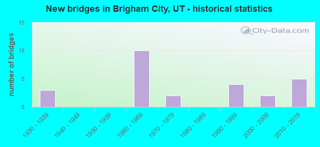
- New bridges - historical statistics
- 31930-1939
- 101960-1969
- 21970-1979
- 41990-1999
- 22000-2009
- 52010-2019
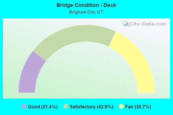
- Bridge Condition - Deck
- 21.4%Good
- 42.9%Satisfactory
- 35.7%Fair
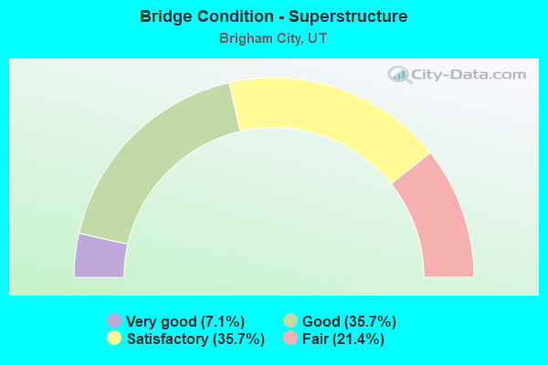
- Bridge Condition - Superstructure
- 7.1%Very good
- 35.7%Good
- 35.7%Satisfactory
- 21.4%Fair
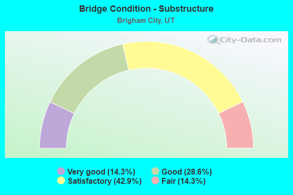
- Bridge Condition - Substructure
- 14.3%Very good
- 28.6%Good
- 42.9%Satisfactory
- 14.3%Fair
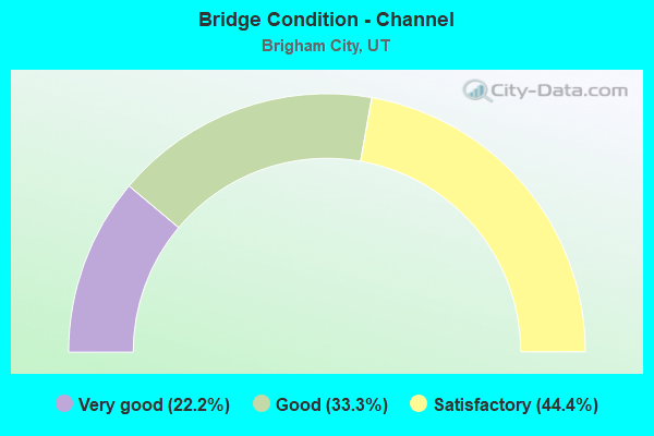
- Bridge Condition - Channel
- 22.2%Very good
- 33.3%Good
- 44.4%Satisfactory
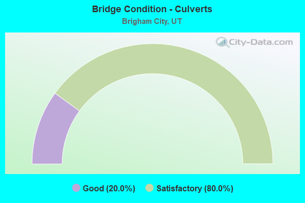
- Bridge Condition - Culverts
- 20.0%Good
- 80.0%Satisfactory
Find on map >> Show street view
Structure Number: 3052E, Location: WEST SIDE OF BRIGHAM CITY (Lat: 41.522333, Lng: -112.045586), Route carried "on" structure: City street 1098, Year Built: 2002, Status: Open, Structure Length: 0.90m (2.95ft), Average Daily Traffic: 1,884 (year 2020), Average Future Daily Traffic: 2,355 (year 2040), Design Load: HS 20+Mod, Features Intersected: BOX ELDER CREEK, Facility Carried by Structure: 1200 WEST STREET
Minimum Vertical Clearance: 30+ m (98+ ft), Kilometerpoint: 1.290, Lanes on structure: 2, Owner: City or Municipal Highway Agency, Approaching Roadway Width: 14.8m (48.6ft), Skew: 4 degrees, Material/Design: Concrete, Design/Construction: Culvert, Number Of Spans In Main Unit: 1, Length of Maximum Span: 8.2m (26.9ft), Curb-To-Curb Width: 14.8m (48.6ft), Out-to-Out Width: 14.8m (48.6ft)
Condition: Channel: Good, Culverts: Satisfactory, Operating Rating: 49.9 metric tons, Method Used To Determine Operating Rating: Load and Resistance Factor Rating (LRFR) rating reported by rating factor(RF) method using HL-93 loadings, Inventory Rating: 33.0 metric tons, Method Used To Determine Inventory Rating: Load Factor (LF) rating reported by rating factor (RF) method using MS18 loading, Structural Evaluation: Equal to present minimum criteria, Deck Geometry: Superior to present desirable criteria, Waterway Adequacy: Better than present minimum criteria, Approach Roadway Alignment: Equal to present desirable criteria, Designated Inspection Frequency: Every 24 months, Inspection Date: November 2021, Deck Structure Type: Concrete Cast-file-Place, Wearing Surface/Protective System: Wearing Surface: Monolithic Concrete, Deck Protection: Epoxy Coated Reinforcing
Find on map >> Show street view
Structure Number: 3064D, Location: 300 N. 300 E.BRIGHAM CITY (Lat: 41.516742, Lng: -112.010925), Route carried "on" structure: City street , Year Built: 1930, Status: Posted for load, Structure Length: 0.78m (2.56ft), Average Daily Traffic: 693 (year 2020), Truck Traffic: 1%, Average Future Daily Traffic: 842 (year 2040), Design Load: HL 93, Features Intersected: BOX ELDER CREEK, Facility Carried by Structure: 300 EAST STREET
Minimum Vertical Clearance: 30+ m (98+ ft), Kilometerpoint: 0.217, Lanes on structure: 2, Owner: City or Municipal Highway Agency, Approaching Roadway Width: 6.7m (22.0ft), Skew: 4 degrees, Material/Design: Concrete, Design/Construction: Frame, Number Of Spans In Main Unit: 1, Length of Maximum Span: 7.2m (23.6ft), Curb or Sidewalk Widths: Left: 1.5m (4.9ft), Right: 0.0m, Curb-To-Curb Width: 6.7m (22.0ft), Out-to-Out Width: 29.9m (98.1ft)
Condition: Deck: Fair, Superstructure: Fair, Substructure: Fair, Channel: Good, Operating Rating: 34.7 metric tons, Method Used To Determine Operating Rating: Load and Resistance Factor Rating (LRFR) rating reported by rating factor(RF) method using HL-93 loadings, Inventory Rating: 19.4 metric tons, Method Used To Determine Inventory Rating: Load Factor (LF) rating reported by rating factor (RF) method using MS18 loading, Structural Evaluation: Somewhat better than minimum adequacy, Deck Geometry: Meets minimum limits, Waterway Adequacy: Somewhat better than minimum adequacy, Approach Roadway Alignment: Equal to present desirable criteria, Designated Inspection Frequency: Every 24 months, Inspection Date: November 2021, Deck Structure Type: Concrete Cast-file-Place, Wearing Surface/Protective System: Wearing Surface: Bituminous
Find on map >> Show street view
Structure Number: 3076E, Location: 3 MI. E. OF CENTER AREA (Lat: 41.478831, Lng: -112.155944), Route carried "on" structure: County highway 1082, Year Built: 2010, Status: Open, Structure Length: 1.27m (4.17ft), Average Daily Traffic: 739 (year 2020), Average Future Daily Traffic: 924 (year 2040), Design Load: HL 93, Features Intersected: WHISTLER CANAL, Facility Carried by Structure: BIRD REFUGE ROAD
Minimum Vertical Clearance: 30+ m (98+ ft), Kilometerpoint: 10.532, Lanes on structure: 2, Owner: County Highway Agency, Approaching Roadway Width: 11.0m (36.1ft), Material/Design: Concrete continuous, Design/Construction: Culvert, Number Of Spans In Main Unit: 3, Length of Maximum Span: 3.3m (10.8ft), Curb-To-Curb Width: 11.0m (36.1ft), Out-to-Out Width: 17.3m (56.8ft)
Condition: Channel: Very good, Culverts: Satisfactory, Operating Rating: 32.4 metric tons, Method Used To Determine Operating Rating: Load and Resistance Factor Rating (LRFR) rating reported by rating factor(RF) method using HL-93 loadings, Inventory Rating: 16.2 metric tons, Method Used To Determine Inventory Rating: Load and Resistance Factor Rating (LRFR) rating reported by rating factor(RF) method using HL-93 loadings, Structural Evaluation: Meets minimum limits, Deck Geometry: Better than present minimum criteria, Waterway Adequacy: Meets minimum limits, Approach Roadway Alignment: Equal to present desirable criteria, Designated Inspection Frequency: Every 24 months, Underwater Inspection Frequency: Every 60 months, Inspection Date: November 2019, Underwater Inspection Date: July 2019
Find on map >> Show street view
Structure Number: 3077E, Location: JUST INSIDE BIRD REFUGE (Lat: 41.509617, Lng: -112.106778), Route carried "on" structure: County highway 1082, Year Built: 2010, Status: Open, Structure Length: 2.46m (8.07ft), Average Daily Traffic: 739 (year 2020), Average Future Daily Traffic: 924 (year 2040), Design Load: HL 93, Features Intersected: REEDER OVERFLOW CHAN., Facility Carried by Structure: BIRD REFUGE ROAD
Minimum Vertical Clearance: 30+ m (98+ ft), Kilometerpoint: 16.236, Lanes on structure: 2, Owner: County Highway Agency, Approaching Roadway Width: 11.0m (36.1ft), Material/Design: Concrete, Design/Construction: Culvert, Number Of Spans In Main Unit: 6, Length of Maximum Span: 3.3m (10.8ft), Curb-To-Curb Width: 11.0m (36.1ft), Out-to-Out Width: 11.0m (36.1ft)
Condition: Channel: Good, Culverts: Good, Operating Rating: 32.4 metric tons, Method Used To Determine Operating Rating: Load and Resistance Factor Rating (LRFR) rating reported by rating factor(RF) method using HL-93 loadings, Inventory Rating: 17.5 metric tons, Method Used To Determine Inventory Rating: Load and Resistance Factor Rating (LRFR) rating reported by rating factor(RF) method using HL-93 loadings, Structural Evaluation: Meets minimum limits, Deck Geometry: Better than present minimum criteria, Waterway Adequacy: Better than present minimum criteria, Approach Roadway Alignment: Equal to present desirable criteria, Designated Inspection Frequency: Every 24 months, Inspection Date: November 2019
Find on map >> Show street view
Structure Number: 3078E, Location: 2.7 MI.NW OF BRIGHAM CITY (Lat: 41.509797, Lng: -112.077042), Route carried "on" structure: County highway 1082, Year Built: 2011, Status: Open, Structure Length: 0.76m (2.49ft), Average Daily Traffic: 739 (year 2020), Average Future Daily Traffic: 924 (year 2040), Design Load: HS 20+Mod, Features Intersected: BLACK SLOUGH, Facility Carried by Structure: COUNTY RD, FA#5230
Minimum Vertical Clearance: 30+ m (98+ ft), Kilometerpoint: 18.718, Lanes on structure: 2, Owner: County Highway Agency, Approaching Roadway Width: 9.9m (32.5ft), Material/Design: Concrete, Design/Construction: Culvert, Number Of Spans In Main Unit: 2, Length of Maximum Span: 3.1m (10.2ft), Curb-To-Curb Width: 9.9m (32.5ft), Out-to-Out Width: 19.0m (62.3ft)
Condition: Channel: Satisfactory, Culverts: Satisfactory, Operating Rating: 32.4 metric tons, Method Used To Determine Operating Rating: Load and Resistance Factor Rating (LRFR) rating reported by rating factor(RF) method using HL-93 loadings, Inventory Rating: 19.8 metric tons, Method Used To Determine Inventory Rating: Load Factor (LF) rating reported by rating factor (RF) method using MS18 loading, Structural Evaluation: Somewhat better than minimum adequacy, Deck Geometry: Equal to present minimum criteria, Waterway Adequacy: Better than present minimum criteria, Approach Roadway Alignment: Better than present minimum criteria, Designated Inspection Frequency: Every 24 months, Inspection Date: November 2021
Find on map >> Show street view
Structure Number: D 383, Location: NORTHWEST OF BRIGHAM CITY (Lat: 41.534156, Lng: -112.059311), Route carried "on" structure: State highway 13, Year Built: 1935, Status: Open, Structure Length: 0.68m (2.23ft), Average Daily Traffic: 7,539 (year 2020), Truck Traffic: 22%, Average Future Daily Traffic: 9,424 (year 2040), Design Load: H 15, Features Intersected: CHASE SLOUGH
Minimum Vertical Clearance: 30+ m (98+ ft), Kilometerpoint: 8.409, Lanes on structure: 2, Owner: State Highway Agency, Approaching Roadway Width: 9.8m (32.2ft), Material/Design: Concrete, Design/Construction: Frame, Number Of Spans In Main Unit: 1, Length of Maximum Span: 6.1m (20.0ft), Curb-To-Curb Width: 9.8m (32.2ft), Out-to-Out Width: 12.2m (40.0ft)
Condition: Deck: Fair, Superstructure: Fair, Substructure: Satisfactory, Channel: Satisfactory, Operating Rating: 44.1 metric tons, Method Used To Determine Operating Rating: Load Factor (LF) rating reported by rating factor (RF) method using MS18 loading, Inventory Rating: 28.2 metric tons, Method Used To Determine Inventory Rating: Load Factor (LF) rating reported by rating factor (RF) method using MS18 loading, Structural Evaluation: Somewhat better than minimum adequacy, Deck Geometry: Meets minimum limits, Waterway Adequacy: Equal to present desirable criteria, Approach Roadway Alignment: Equal to present desirable criteria, Designated Inspection Frequency: Every 24 months, Inspection Date: May 2021, Deck Structure Type: Concrete Cast-file-Place, Wearing Surface/Protective System: Wearing Surface: Bituminous
Find on map >> Show street view
Structure Number: E1349, Location: WEST OF BRIGHAM CITY (Lat: 41.524722, Lng: -112.064944), Route carried "on" structure: Interstate 15, Year Built: 1965, Status: Open, Structure Length: 0.67m (2.20ft), Average Daily Traffic: 28,705 (year 2020), Truck Traffic: 31%, Average Future Daily Traffic: 35,881 (year 2040), Design Load: HS 20+Mod, Features Intersected: BLACK SLOUGH
Minimum Vertical Clearance: 30+ m (98+ ft), Kilometerpoint: 587.387, Lanes on structure: 4, Base Highway Network: Yes, Owner: State Highway Agency, Approaching Roadway Width: 23.2m (76.1ft), Skew: 30 degrees, Material/Design: Concrete continuous, Design/Construction: Culvert, Number Of Spans In Main Unit: 2, Length of Maximum Span: 3.0m (9.8ft)
Condition: Channel: Satisfactory, Culverts: Satisfactory, Operating Rating: 32.4 metric tons, Method Used To Determine Operating Rating: Load Factor (LF) rating reported by rating factor (RF) method using MS18 loading, Inventory Rating: 32.4 metric tons, Method Used To Determine Inventory Rating: Load Factor (LF) rating reported by rating factor (RF) method using MS18 loading, Structural Evaluation: Equal to present minimum criteria, Waterway Adequacy: Equal to present minimum criteria, Approach Roadway Alignment: Equal to present desirable criteria, Designated Inspection Frequency: Every 24 months, Inspection Date: May 2021
Find on map >> Show street view
Structure Number: F 1, Location: 1.5 Mi N of N Brigham Int (Lat: 41.563081, Lng: -112.070408), Route carried "on" structure: County highway , Year Built: 1963, Status: Open, Structure Length: 6.66m (21.85ft), Average Daily Traffic: 500 (year 2020), Truck Traffic: 23%, Average Future Daily Traffic: 1,000 (year 2040), Design Load: HS 20+Mod, Features Intersected: I-15 (SR-15) NBL AND SBL, Facility Carried by Structure: CO RD (CEMENT PL.)
Minimum Vertical Clearance: 30+ m (98+ ft), Kilometerpoint: 0.306, Lanes on structure: 2, Lanes under structure: 4, Owner: State Highway Agency, Approaching Roadway Width: 7.3m (24.0ft), Material/Design: Prestressed concrete, Design/Construction: Stringer/Multi-beam, Number Of Spans In Main Unit: 4, Length of Maximum Span: 21.8m (71.5ft), Curb or Sidewalk Widths: Left: 0.5m (1.6ft), Right: 0.5m (1.6ft), Curb-To-Curb Width: 7.3m (24.0ft), Out-to-Out Width: 8.7m (28.5ft)
Condition: Deck: Satisfactory, Superstructure: Satisfactory, Substructure: Satisfactory, Operating Rating: 48.6 metric tons, Method Used To Determine Operating Rating: Load and Resistance Factor Rating (LRFR) rating reported by rating factor(RF) method using HL-93 loadings, Inventory Rating: 37.6 metric tons, Method Used To Determine Inventory Rating: Load Factor (LF) rating reported by rating factor (RF) method using MS18 loading, Structural Evaluation: Equal to present minimum criteria, Deck Geometry: Meets minimum limits, Underclear: Somewhat better than minimum adequacy, Approach Roadway Alignment: Equal to present minimum criteria, Designated Inspection Frequency: Every 24 months, Inspection Date: May 2021, Deck Structure Type: Concrete Cast-file-Place, Wearing Surface/Protective System: Wearing Surface: Bituminous
Find on map >> Show street view
Structure Number: F 166, Location: 1.7 MI.E.of BRIGHAM CITY (Lat: 41.499925, Lng: -111.990631), Route carried "on" structure: US 90, Year Built: 1962, Year Reconstructed: 1971, Status: Open, Structure Length: 0.91m (2.99ft), Average Daily Traffic: 9,704 (year 2020), Truck Traffic: 26%, Average Future Daily Traffic: 12,130 (year 2040), Design Load: HS 20+Mod, Features Intersected: BOX ELDER CREEK
Minimum Vertical Clearance: 30+ m (98+ ft), Kilometerpoint: 0.177, Lanes on structure: 5, Base Highway Network: Yes (Inventory Route: 90NR0, Subroute: 2), Owner: State Highway Agency, Approaching Roadway Width: 19.5m (64.0ft), Skew: 34 degrees, Material/Design: Prestressed concrete, Design/Construction: Stringer/Multi-beam, Number Of Spans In Main Unit: 1, Length of Maximum Span: 8.6m (28.2ft), Curb-To-Curb Width: 19.5m (64.0ft), Out-to-Out Width: 39.8m (130.6ft)
Condition: Deck: Satisfactory, Superstructure: Satisfactory, Substructure: Satisfactory, Channel: Satisfactory, Operating Rating: 32.4 metric tons, Method Used To Determine Operating Rating: Load and Resistance Factor Rating (LRFR) rating reported by rating factor(RF) method using HL-93 loadings, Inventory Rating: 21.1 metric tons, Method Used To Determine Inventory Rating: Load Factor (LF) rating reported by rating factor (RF) method using MS18 loading, Structural Evaluation: Somewhat better than minimum adequacy, Deck Geometry: Meets minimum limits, Waterway Adequacy: Equal to present minimum criteria, Approach Roadway Alignment: Equal to present desirable criteria, Designated Inspection Frequency: Every 24 months, Inspection Date: May 2021, Deck Structure Type: Concrete Cast-file-Place, Wearing Surface/Protective System: Wearing Surface: Bituminous
Find on map >> Show street view
Structure Number: F 584, Location: FOREST ST.INT.W. BRIGHAM (Lat: 41.509858, Lng: -112.060778), Route carried "on" structure: County highway 1082, Year Built: 1995, Status: Open, Structure Length: 7.88m (25.85ft), Average Daily Traffic: 5,549 (year 2020), Average Future Daily Traffic: 6,936 (year 2040), Design Load: HS 20+Mod, Features Intersected: I-15 (SR-15) NBL AND SBL, Facility Carried by Structure: FOREST ST.INT.X-RD
Minimum Vertical Clearance: 30+ m (98+ ft), Kilometerpoint: 20.075, Lanes on structure: 2, Lanes under structure: 4, Owner: State Highway Agency, Approaching Roadway Width: 14.8m (48.6ft), Skew: 1 degrees, Material/Design: Prestressed concrete continuous, Design/Construction: Stringer/Multi-beam, Number Of Spans In Main Unit: 2, Length of Maximum Span: 39.0m (128.0ft), Curb or Sidewalk Widths: Left: 2.4m (7.9ft), Right: 0.0m, Curb-To-Curb Width: 14.8m (48.6ft), Out-to-Out Width: 18.6m (61.0ft)
Condition: Deck: Satisfactory, Superstructure: Satisfactory, Substructure: Fair, Operating Rating: 43.7 metric tons, Method Used To Determine Operating Rating: Load and Resistance Factor Rating (LRFR) rating reported by rating factor(RF) method using HL-93 loadings, Inventory Rating: 33.4 metric tons, Method Used To Determine Inventory Rating: Load and Resistance Factor Rating (LRFR) rating reported by rating factor(RF) method using HL-93 loadings, Structural Evaluation: Somewhat better than minimum adequacy, Deck Geometry: Superior to present desirable criteria, Underclear: Better than present minimum criteria, Approach Roadway Alignment: Equal to present desirable criteria, Designated Inspection Frequency: Every 24 months, Inspection Date: May 2021, Deck Structure Type: Concrete Cast-file-Place, Wearing Surface/Protective System: Wearing Surface: Monolithic Concrete, Deck Protection: Epoxy Coated Reinforcing
Find on map >> Show street view
Structure Number: F 599, Location: NORTH SIDE BRIGHAM CITY (Lat: 41.529475, Lng: -112.022811), Route carried "on" structure: City street 1086, Year Built: 1997, Status: Open, Structure Length: 4.25m (13.94ft), Average Daily Traffic: 4,870 (year 2020), Average Future Daily Traffic: 6,088 (year 2040), Design Load: HS 20+Mod, Features Intersected: SR-13, Facility Carried by Structure: 5TH WEST STREET
Minimum Vertical Clearance: 30+ m (98+ ft), Kilometerpoint: 4.872, Lanes on structure: 2, Lanes under structure: 2, Owner: State Highway Agency, Approaching Roadway Width: 14.4m (47.2ft), Material/Design: Prestressed concrete, Design/Construction: Stringer/Multi-beam, Number Of Spans In Main Unit: 2, Length of Maximum Span: 21.1m (69.2ft), Curb or Sidewalk Widths: Left: 2.3m (7.5ft), Right: 2.3m (7.5ft), Curb-To-Curb Width: 14.4m (47.2ft), Out-to-Out Width: 19.5m (64.0ft)
Condition: Deck: Satisfactory, Superstructure: Good, Substructure: Good, Operating Rating: 51.8 metric tons, Method Used To Determine Operating Rating: Load and Resistance Factor Rating (LRFR) rating reported by rating factor(RF) method using HL-93 loadings, Inventory Rating: 35.3 metric tons, Method Used To Determine Inventory Rating: Load Factor (LF) rating reported by rating factor (RF) method using MS18 loading, Structural Evaluation: Better than present minimum criteria, Deck Geometry: Superior to present desirable criteria, Underclear: High priority of corrective action, Approach Roadway Alignment: Equal to present desirable criteria, Designated Inspection Frequency: Every 24 months, Inspection Date: May 2021, Deck Structure Type: Concrete Cast-file-Place, Wearing Surface/Protective System: Wearing Surface: Monolithic Concrete, Deck Protection: Epoxy Coated Reinforcing
Find on map >> Show street view
Structure Number: 1C 334, Location: NORTH BRIGHAM INTERCHANGE (Lat: 41.534981, Lng: -112.066008), Route carried "on" structure: Interstate 15, Year Built: 1967, Status: Open, Structure Length: 7.31m (23.98ft), Average Daily Traffic: 28,705 (year 2020), Truck Traffic: 31%, Average Future Daily Traffic: 35,881 (year 2040), Design Load: HS 20+Mod, Features Intersected: SR-13 AND UPRR
Minimum Vertical Clearance: 7.88m (25.85ft), Kilometerpoint: 588.719, Lanes on structure: 2, Lanes under structure: 4, Base Highway Network: Yes, Owner: State Highway Agency, Approaching Roadway Width: 9.6m (31.5ft), Skew: 2 degrees, Material/Design: Steel continuous, Design/Construction: Stringer/Multi-beam, Number Of Spans In Main Unit: 3, Length of Maximum Span: 47.5m (155.8ft), Curb-To-Curb Width: 9.6m (31.5ft), Out-to-Out Width: 10.6m (34.8ft)
Condition: Deck: Fair, Superstructure: Satisfactory, Substructure: Good, Operating Rating: 32.7 metric tons, Method Used To Determine Operating Rating: Load Factor (LF) rating reported by rating factor (RF) method using MS18 loading, Inventory Rating: 24.0 metric tons, Method Used To Determine Inventory Rating: Load Factor (LF) rating reported by rating factor (RF) method using MS18 loading, Structural Evaluation: Somewhat better than minimum adequacy, Deck Geometry: Meets minimum limits, Underclear: Meets minimum limits, Approach Roadway Alignment: Better than present minimum criteria, Designated Inspection Frequency: Every 24 months, Inspection Date: May 2021, Deck Structure Type: Concrete Cast-file-Place, Wearing Surface/Protective System: Wearing Surface: Bituminous, Membrane: Preformed Fabric
Find on map >> Show street view
Structure Number: 1C 451, Location: 11th SO., BRIGHAM CITY (Lat: 41.486194, Lng: -112.044211), Route carried "on" structure: US 91, Year Built: 1967, Status: Open, Structure Length: 5.36m (17.59ft), Average Daily Traffic: 19,963 (year 2020), Truck Traffic: 24%, Average Future Daily Traffic: 24,954 (year 2040), Design Load: HS 20+Mod, Features Intersected: UNION PACIFIC RAILROAD
Minimum Vertical Clearance: 30+ m (98+ ft), Kilometerpoint: 0.901, Lanes on structure: 2, Base Highway Network: Yes, Owner: State Highway Agency, Approaching Roadway Width: 8.9m (29.2ft), Skew: 2 degrees, Material/Design: Steel continuous, Design/Construction: Stringer/Multi-beam, Number Of Spans In Main Unit: 3, Length of Maximum Span: 35.4m (116.1ft), Curb or Sidewalk Widths: Left: 0.9m (3.0ft), Right: 0.0m, Curb-To-Curb Width: 8.9m (29.2ft), Out-to-Out Width: 10.6m (34.8ft)
Condition: Deck: Satisfactory, Superstructure: Good, Substructure: Satisfactory, Operating Rating: 46.3 metric tons, Method Used To Determine Operating Rating: Load and Resistance Factor Rating (LRFR) rating reported by rating factor(RF) method using HL-93 loadings, Inventory Rating: 39.5 metric tons, Method Used To Determine Inventory Rating: Load Factor (LF) rating reported by rating factor (RF) method using MS18 loading, Structural Evaluation: Equal to present minimum criteria, Deck Geometry: High priority of corrective action, Underclear: Better than present minimum criteria, Approach Roadway Alignment: Better than present minimum criteria, Designated Inspection Frequency: Every 24 months, Inspection Date: May 2021, Deck Structure Type: Concrete Cast-file-Place, Wearing Surface/Protective System: Wearing Surface: Bituminous, Membrane: Preformed Fabric
Find on map >> Show street view
Structure Number: 1F 168, Location: 1.5 MI.EAST BRIGHAM CITY (Lat: 41.499550, Lng: -111.992706), Route carried "on" structure: Ramp State highway 90, Year Built: 1971, Status: Open, Structure Length: 9.12m (29.92ft), Average Daily Traffic: 9,704 (year 2020), Truck Traffic: 26%, Average Future Daily Traffic: 12,130 (year 2040), Design Load: HS 20+Mod, Features Intersected: US-91 (SR-91) NBL &
Minimum Vertical Clearance: 30+ m (98+ ft), Kilometerpoint: 0.267, Lanes on structure: 1, Lanes under structure: 4, Owner: State Highway Agency, Approaching Roadway Width: 7.3m (24.0ft), Skew: 4 degrees, Material/Design: Prestressed concrete, Design/Construction: Stringer/Multi-beam, Number Of Spans In Main Unit: 4, Length of Maximum Span: 29.9m (98.1ft), Curb-To-Curb Width: 7.3m (24.0ft), Out-to-Out Width: 8.4m (27.6ft)
Condition: Deck: Fair, Superstructure: Fair, Substructure: Satisfactory, Operating Rating: 38.2 metric tons, Method Used To Determine Operating Rating: Load and Resistance Factor Rating (LRFR) rating reported by rating factor(RF) method using HL-93 loadings, Inventory Rating: 32.7 metric tons, Method Used To Determine Inventory Rating: Load Factor (LF) rating reported by rating factor (RF) method using MS18 loading, Structural Evaluation: Somewhat better than minimum adequacy, Deck Geometry: Better than present minimum criteria, Underclear: Somewhat better than minimum adequacy, Approach Roadway Alignment: Equal to present minimum criteria, Designated Inspection Frequency: Every 24 months, Inspection Date: May 2021, Deck Structure Type: Concrete Cast-file-Place, Wearing Surface/Protective System: Wearing Surface: Bituminous
Find on map >> Show street view
Structure Number: 3C 334, Location: NORTH BRIGHAM INTERCHANGE (Lat: 41.535831, Lng: -112.066450), Route carried "on" structure: Interstate 15, Year Built: 1967, Status: Open, Structure Length: 7.31m (23.98ft), Average Daily Traffic: 28,705 (year 2020), Truck Traffic: 31%, Average Future Daily Traffic: 35,881 (year 2040), Design Load: HS 20+Mod, Features Intersected: SR-13 AND UPRR
Minimum Vertical Clearance: 30+ m (98+ ft), Kilometerpoint: 588.627, Lanes on structure: 3, Lanes under structure: 3, Base Highway Network: Yes, Owner: State Highway Agency, Approaching Roadway Width: 9.6m (31.5ft), Skew: 2 degrees, Material/Design: Steel continuous, Design/Construction: Stringer/Multi-beam, Number Of Spans In Main Unit: 3, Length of Maximum Span: 47.5m (155.8ft), Curb-To-Curb Width: 13.2m (43.3ft), Out-to-Out Width: 14.2m (46.6ft)
Condition: Deck: Satisfactory, Superstructure: Satisfactory, Substructure: Good, Operating Rating: 39.2 metric tons, Method Used To Determine Operating Rating: Load and Resistance Factor Rating (LRFR) rating reported by rating factor(RF) method using HL-93 loadings, Inventory Rating: 30.5 metric tons, Method Used To Determine Inventory Rating: Load Factor (LF) rating reported by rating factor (RF) method using MS18 loading, Structural Evaluation: Equal to present minimum criteria, Deck Geometry: Meets minimum limits, Underclear: Meets minimum limits, Approach Roadway Alignment: Equal to present desirable criteria, Designated Inspection Frequency: Every 24 months, Inspection Date: May 2021, Deck Structure Type: Concrete Cast-file-Place, Wearing Surface/Protective System: Wearing Surface: Bituminous, Membrane: Preformed Fabric
Find on map >> Show street view
Structure Number: 3C 451, Location: 11TH SO BRIGHAM CITY (Lat: 41.486267, Lng: -112.042886), Route carried "on" structure: US 91, Year Built: 1967, Status: Open, Structure Length: 5.36m (17.59ft), Average Daily Traffic: 19,963 (year 2020), Truck Traffic: 24%, Average Future Daily Traffic: 24,954 (year 2040), Design Load: HS 20+Mod, Features Intersected: UNION PACIFIC RAILROAD
Minimum Vertical Clearance: 30+ m (98+ ft), Kilometerpoint: 1.012, Lanes on structure: 2, Base Highway Network: Yes, Owner: State Highway Agency, Approaching Roadway Width: 10.1m (33.1ft), Skew: 2 degrees, Material/Design: Steel continuous, Design/Construction: Stringer/Multi-beam, Number Of Spans In Main Unit: 3, Length of Maximum Span: 35.4m (116.1ft), Curb or Sidewalk Widths: Left: 0.0m, Right: 1.0m (3.3ft), Curb-To-Curb Width: 10.1m (33.1ft), Out-to-Out Width: 10.6m (34.8ft)
Condition: Deck: Fair, Superstructure: Good, Substructure: Satisfactory, Operating Rating: 46.3 metric tons, Method Used To Determine Operating Rating: Load and Resistance Factor Rating (LRFR) rating reported by rating factor(RF) method using HL-93 loadings, Inventory Rating: 39.5 metric tons, Method Used To Determine Inventory Rating: Load Factor (LF) rating reported by rating factor (RF) method using MS18 loading, Structural Evaluation: Equal to present minimum criteria, Deck Geometry: Somewhat better than minimum adequacy, Underclear: Better than present minimum criteria, Approach Roadway Alignment: Equal to present desirable criteria, Designated Inspection Frequency: Every 24 months, Inspection Date: May 2021, Deck Structure Type: Concrete Cast-file-Place, Wearing Surface/Protective System: Wearing Surface: Bituminous, Membrane: Preformed Fabric
Find on map >> Show street view
Structure Number: 65530-51933, Location: NEAR JCT I-15 & W. FOREST (Lat: 41.508833, Lng: -112.069833), Route carried "on" structure: Federal lands road , Year Built: 2002, Status: Open, Structure Length: 2.13m (6.99ft), Average Daily Traffic: 50 (year 2020), Average Future Daily Traffic: 50 (year 2040), Features Intersected: EAST SLOUGH, Facility Carried by Structure: EDUCATION CENTER L
Minimum Vertical Clearance: 30.48m (100.00ft), Kilometerpoint: 0.161, Lanes on structure: 2, Owner: Bureau of Fish and Wildlife, Approaching Roadway Width: 8.5m (27.9ft), Material/Design: Wood or Timber, Design/Construction: Slab, Number Of Spans In Main Unit: 3, Length of Maximum Span: 8.8m (28.9ft), Curb-To-Curb Width: 7.6m (24.9ft), Out-to-Out Width: 8.2m (26.9ft)
Condition: Deck: Good, Superstructure: Good, Substructure: Very good, Channel: Very good, Operating Rating: 67.1 metric tons, Method Used To Determine Operating Rating: Allowable Stress (AS), Inventory Rating: 47.2 metric tons, Method Used To Determine Inventory Rating: Allowable Stress (AS), Structural Evaluation: Better than present minimum criteria, Deck Geometry: Equal to present minimum criteria, Waterway Adequacy: Equal to present desirable criteria, Approach Roadway Alignment: Equal to present desirable criteria, Designated Inspection Frequency: Every 48 months, Inspection Date: October 2020, Deck Structure Type: Wood or Timber, Wearing Surface/Protective System: Wearing Surface: Bituminous
Find on map >> Show street view
Structure Number: 2F 852, Location: 1100 South Intchg (Lat: 41.485758, Lng: -112.053503), Route carried "on" structure: State highway 91, Year Built: 2013, Status: Open, Structure Length: 5.66m (18.57ft), Average Daily Traffic: 19,963 (year 2020), Truck Traffic: 24%, Average Future Daily Traffic: 24,954 (year 2040), Design Load: HL 93, Features Intersected: I-15
Minimum Vertical Clearance: 30+ m (98+ ft), Kilometerpoint: 0.005, Lanes on structure: 2, Lanes under structure: 4, Base Highway Network: Yes, Owner: State Highway Agency, Approaching Roadway Width: 12.2m (40.0ft), Material/Design: Prestressed concrete, Design/Construction: Stringer/Multi-beam, Number Of Spans In Main Unit: 2, Length of Maximum Span: 27.8m (91.2ft), Curb-To-Curb Width: 12.2m (40.0ft), Out-to-Out Width: 13.1m (43.0ft)
Condition: Deck: Good, Superstructure: Good, Substructure: Very good, Operating Rating: 71.3 metric tons, Method Used To Determine Operating Rating: Load and Resistance Factor Rating (LRFR) rating reported by rating factor(RF) method using HL-93 loadings, Inventory Rating: 37.9 metric tons, Method Used To Determine Inventory Rating: Load and Resistance Factor Rating (LRFR) rating reported by rating factor(RF) method using HL-93 loadings, Structural Evaluation: Better than present minimum criteria, Deck Geometry: Better than present minimum criteria, Underclear: Superior to present desirable criteria, Approach Roadway Alignment: Equal to present desirable criteria, Designated Inspection Frequency: Every 24 months, Inspection Date: May 2021, Deck Structure Type: Concrete Precast Panels, Wearing Surface/Protective System: Wearing Surface: Epoxy Overlay, Deck Protection: Epoxy Coated Reinforcing
Find on map >> Show street view
Structure Number: 4F 852, Location: 1100 South Intchg (Lat: 41.485692, Lng: -112.052658), Route carried "on" structure: State highway 91, Year Built: 2014, Status: Open, Structure Length: 5.66m (18.57ft), Average Daily Traffic: 19,963 (year 2020), Truck Traffic: 24%, Average Future Daily Traffic: 24,954 (year 2040), Design Load: HL 93, Features Intersected: I-15
Minimum Vertical Clearance: 30+ m (98+ ft), Kilometerpoint: 0.218, Lanes on structure: 2, Lanes under structure: 4, Base Highway Network: Yes, Owner: State Highway Agency, Approaching Roadway Width: 12.2m (40.0ft), Material/Design: Prestressed concrete, Design/Construction: Stringer/Multi-beam, Number Of Spans In Main Unit: 2, Length of Maximum Span: 27.8m (91.2ft), Curb-To-Curb Width: 12.2m (40.0ft), Out-to-Out Width: 13.1m (43.0ft)
Condition: Deck: Good, Superstructure: Very good, Substructure: Good, Operating Rating: 71.3 metric tons, Method Used To Determine Operating Rating: Load and Resistance Factor Rating (LRFR) rating reported by rating factor(RF) method using HL-93 loadings, Inventory Rating: 37.9 metric tons, Method Used To Determine Inventory Rating: Load and Resistance Factor Rating (LRFR) rating reported by rating factor(RF) method using HL-93 loadings, Structural Evaluation: Better than present minimum criteria, Deck Geometry: Better than present minimum criteria, Underclear: Superior to present desirable criteria, Approach Roadway Alignment: Equal to present desirable criteria, Designated Inspection Frequency: Every 24 months, Inspection Date: May 2021, Deck Structure Type: Concrete Precast Panels, Wearing Surface/Protective System: Wearing Surface: Epoxy Overlay, Deck Protection: Epoxy Coated Reinforcing
Find on map >> Show street view
Structure Number: C 147, Location: 0.8 MI.NO.OF BRIGHAM CITY (Lat: 41.529575, Lng: -112.029692), Route carried "under" structure: State highway 13, Year Built: 1937, Structure Length: 0. m, Average Daily Traffic: 4,597 (year 2020), Truck Traffic: 20%, Features Intersected: SR-13, Facility Carried by Structure: UNION PACIFIC RR
Minimum Vertical Clearance: 4.57m (14.99ft), Kilometerpoint: 5.872, Lanes under structure: 2, Material/Design: Steel, Design/Construction: Stringer/Multi-beam, Length of Maximum Span: 10.3m (33.8ft)
Find on map >> Show street view
Structure Number: F 1, Location: 1.5 Mi N of N Brigham Int (Lat: 41.563081, Lng: -112.070408), Route carried "under" structure: Interstate 15, Year Built: 1963, Structure Length: 0. m, Average Daily Traffic: 26,325 (year 2020), Truck Traffic: 33%, Features Intersected: I-15 (SR-15) NBL AND SBL, Facility Carried by Structure: CO RD (CEMENT PL.)
Minimum Vertical Clearance: 5.11m (16.77ft), Kilometerpoint: 591.357, Lanes on structure: 2, Lanes under structure: 4, Material/Design: Prestressed concrete, Design/Construction: Stringer/Multi-beam, Length of Maximum Span: 21.8m (71.5ft)
Find on map >> Show street view
Structure Number: F 584, Location: FOREST ST.INT.W. BRIGHAM (Lat: 41.509858, Lng: -112.060778), Route carried "under" structure: Interstate 15, Year Built: 1995, Structure Length: 0. m, Average Daily Traffic: 29,544 (year 2020), Truck Traffic: 29%, Features Intersected: I-15 (SR-15) NBL AND SBL, Facility Carried by Structure: FOREST ST.INT.X-RD
Minimum Vertical Clearance: 5.29m (17.36ft), Kilometerpoint: 585.378, Lanes on structure: 2, Lanes under structure: 4, Material/Design: Prestressed concrete continuous, Design/Construction: Stringer/Multi-beam, Length of Maximum Span: 39.0m (128.0ft)
Find on map >> Show street view
Structure Number: F 599, Location: NORTH SIDE BRIGHAM CITY (Lat: 41.529475, Lng: -112.022811), Route carried "under" structure: State highway 13, Year Built: 1997, Structure Length: 0. m, Average Daily Traffic: 4,597 (year 2020), Truck Traffic: 20%, Features Intersected: SR-13, Facility Carried by Structure: 5TH WEST STREET
Minimum Vertical Clearance: 5.07m (16.63ft), Kilometerpoint: 5.280, Lanes on structure: 2, Lanes under structure: 2, Material/Design: Prestressed concrete, Design/Construction: Stringer/Multi-beam, Length of Maximum Span: 21.1m (69.2ft)
Find on map >> Show street view
Structure Number: 1C 334, Location: NORTH BRIGHAM INTERCHANGE (Lat: 41.534981, Lng: -112.066008), Route carried "under" structure: State highway 13, Year Built: 1967, Structure Length: 0. m, Average Daily Traffic: 7,539 (year 2020), Truck Traffic: 22%, Features Intersected: SR-13 AND UPRR, Facility Carried by Structure: I-15 (SR-15) NBL
Minimum Vertical Clearance: 7.89m (25.89ft), Kilometerpoint: 8.979, Lanes on structure: 2, Lanes under structure: 4, Material/Design: Steel continuous, Design/Construction: Stringer/Multi-beam, Length of Maximum Span: 47.5m (155.8ft)
Find on map >> Show street view
Structure Number: 1F 168, Location: 1.5 MI.EAST BRIGHAM CITY (Lat: 41.499550, Lng: -111.992706), Route carried "under" structure: Ramp State highway 91, Year Built: 1971, Structure Length: 0. m, Average Daily Traffic: 20,134 (year 2020), Truck Traffic: 23%, Features Intersected: US-91 (SR-91) NBL &, Facility Carried by Structure: SR-90, EBL RAMP
Minimum Vertical Clearance: 5.25m (17.22ft), Kilometerpoint: 6.254, Lanes on structure: 1, Lanes under structure: 2, Material/Design: Prestressed concrete, Design/Construction: Stringer/Multi-beam, Length of Maximum Span: 29.9m (98.1ft)
Find on map >> Show street view
Structure Number: 3C 334, Location: NORTH BRIGHAM INTERCHANGE (Lat: 41.535831, Lng: -112.066450), Route carried "under" structure: State highway 13, Year Built: 1967, Structure Length: 0. m, Average Daily Traffic: 9,842 (year 2020), Truck Traffic: 24%, Features Intersected: SR-13 AND UPRR, Facility Carried by Structure: I-15 (SR-15) SBL
Minimum Vertical Clearance: 7.87m (25.82ft), Kilometerpoint: 9.011, Lanes on structure: 3, Lanes under structure: 3, Material/Design: Steel continuous, Design/Construction: Stringer/Multi-beam, Length of Maximum Span: 47.5m (155.8ft)