Bridge Statistics for Brookville, Kansas (KS)
Condition, Traffic, Stress, Structural Evaluation, Project Costs
- National Bridge Inventory (NBI) Statistics
- 19Number of bridges
- 105ft / 32.1mTotal length
- $135,000Total costs
- 16,392Total average daily traffic
- 1,261Total average daily truck traffic
- 18,145Total future (year 2034) average daily traffic
- National Bridge Inventory (NBI) Registered Bridges for Brookville
- No street view available for this location
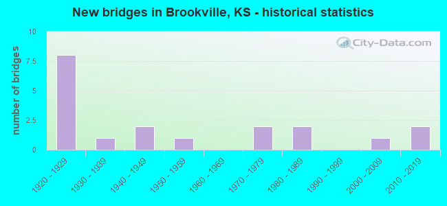
- New bridges - historical statistics
- 81920-1929
- 11930-1939
- 21940-1949
- 11950-1959
- 21970-1979
- 21980-1989
- 12000-2009
- 22010-2019
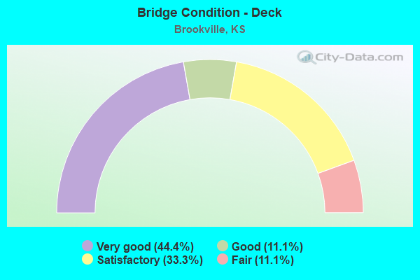
- Bridge Condition - Deck
- 44.4%Very good
- 11.1%Good
- 33.3%Satisfactory
- 11.1%Fair
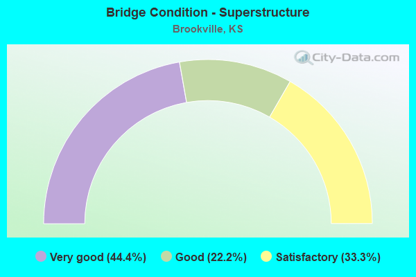
- Bridge Condition - Superstructure
- 44.4%Very good
- 22.2%Good
- 33.3%Satisfactory
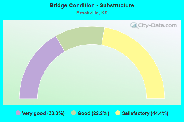
- Bridge Condition - Substructure
- 33.3%Very good
- 22.2%Good
- 44.4%Satisfactory
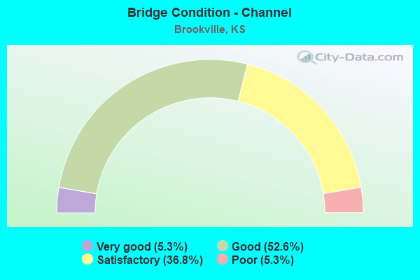
- Bridge Condition - Channel
- 5.3%Very good
- 52.6%Good
- 36.8%Satisfactory
- 5.3%Poor
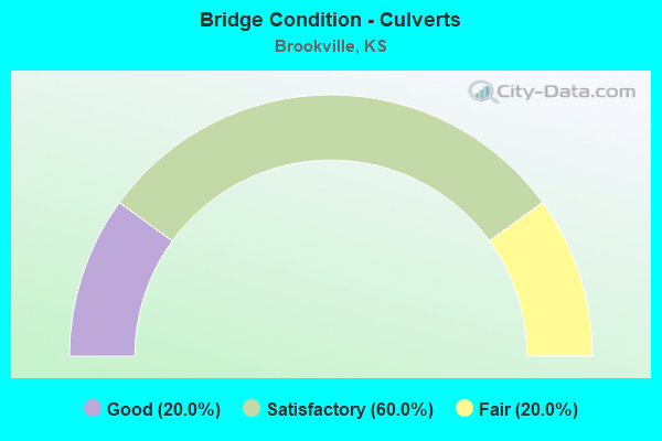
- Bridge Condition - Culverts
- 20.0%Good
- 60.0%Satisfactory
- 20.0%Fair
Find on map >> Show street view
Structure Number: 85021, Location: 0.3S 0.2W OF BROOKVILLE (Lat: 38.768786, Lng: -97.873386), Route carried "on" structure: County highway 447, Year Built: 1984, Status: Open, Structure Length: 4.63m (15.19ft), Average Daily Traffic: 55 (year 2017), Average Future Daily Traffic: 67 (year 2043), Design Load: HS 20, Features Intersected: WEST SPRING CREEK
Minimum Vertical Clearance: 30.47m (99.97ft), Kilometerpoint: 19.308, Lanes on structure: 2, Owner: County Highway Agency, Approaching Roadway Width: 7.3m (24.0ft), Material/Design: Prestressed concrete continuous, Design/Construction: Tee Beam, Number Of Spans In Main Unit: 3, Length of Maximum Span: 15.2m (49.9ft), Curb-To-Curb Width: 8.5m (27.9ft), Out-to-Out Width: 9.1m (29.9ft)
Condition: Deck: Very good, Superstructure: Very good, Substructure: Very good, Channel: Good, Operating Rating: 44.1 metric tons, Method Used To Determine Operating Rating: Load Factor (LF), Inventory Rating: 24.6 metric tons, Method Used To Determine Inventory Rating: Load Factor (LF), Structural Evaluation: Equal to present minimum criteria, Deck Geometry: Better than present minimum criteria, Waterway Adequacy: Better than present minimum criteria, Approach Roadway Alignment: Better than present minimum criteria, Designated Inspection Frequency: Every 24 months, Inspection Date: Febuary 2021, Other Special Inspection Date: November 2020, Deck Structure Type: Concrete Cast-file-Place, Wearing Surface/Protective System: Wearing Surface: Epoxy Overlay, Membrane: Epoxy
Find on map >> Show street view
Structure Number: 85076330472, Location: 1.3S OF BROOKVILLE (Lat: 38.758264, Lng: -97.868636), Route carried "on" structure: County highway , Year Built: 1972, Status: Open, Structure Length: 2.50m (8.20ft), Average Daily Traffic: 33 (year 2017), Average Future Daily Traffic: 40 (year 2043), Features Intersected: STREAM, Facility Carried by Structure: LOCAL 472-763.3
Minimum Vertical Clearance: 30.47m (99.97ft), Kilometerpoint: 0.000, Lanes on structure: 2, Owner: County Highway Agency, Approaching Roadway Width: 4.9m (16.1ft), Material/Design: Steel, Design/Construction: Stringer/Multi-beam, Number Of Spans In Main Unit: 3, Length of Maximum Span: 9.1m (29.9ft), Curb-To-Curb Width: 7.3m (24.0ft), Out-to-Out Width: 7.3m (24.0ft)
Condition: Deck: Satisfactory, Superstructure: Satisfactory, Substructure: Satisfactory, Channel: Satisfactory, Operating Rating: 49.6 metric tons, Method Used To Determine Operating Rating: Load Factor (LF), Inventory Rating: 29.7 metric tons, Method Used To Determine Inventory Rating: Load Factor (LF), Structural Evaluation: Equal to present minimum criteria, Deck Geometry: Equal to present minimum criteria, Waterway Adequacy: Equal to present desirable criteria, Approach Roadway Alignment: Equal to present desirable criteria, Designated Inspection Frequency: Every 24 months, Inspection Date: Febuary 2021, Deck Structure Type: Corrugated Steel, Wearing Surface/Protective System: Wearing Surface: Bituminous
Find on map >> Show street view
Structure Number: 8507635047, Location: 2.0S 5.9W OF BAVARIA (Lat: 38.769358, Lng: -97.864589), Route carried "on" structure: County highway , Year Built: 2004, Status: Open, Structure Length: 3.59m (11.78ft), Average Daily Traffic: 21 (year 2017), Average Future Daily Traffic: 26 (year 2043), Design Load: HS 20, Features Intersected: WEST SPRING CREEK, Facility Carried by Structure: LOCAL 470-763.5
Minimum Vertical Clearance: 30.47m (99.97ft), Kilometerpoint: 0.000, Lanes on structure: 2, Owner: County Highway Agency, Approaching Roadway Width: 6.7m (22.0ft), Material/Design: Concrete continuous, Design/Construction: Slab, Number Of Spans In Main Unit: 3, Length of Maximum Span: 14.0m (45.9ft), Curb-To-Curb Width: 8.6m (28.2ft), Out-to-Out Width: 9.2m (30.2ft)
Condition: Deck: Very good, Superstructure: Good, Substructure: Good, Channel: Good, Operating Rating: 46.6 metric tons, Method Used To Determine Operating Rating: Load Factor (LF), Inventory Rating: 27.9 metric tons, Method Used To Determine Inventory Rating: Load Factor (LF), Structural Evaluation: Better than present minimum criteria, Deck Geometry: Better than present minimum criteria, Waterway Adequacy: Equal to present desirable criteria, Approach Roadway Alignment: Equal to present desirable criteria, Designated Inspection Frequency: Every 24 months, Inspection Date: Febuary 2021, Deck Structure Type: Concrete Cast-file-Place, Wearing Surface/Protective System: Deck Protection: Epoxy Coated Reinforcing
Find on map >> Show street view
Structure Number: 850765004703, Location: 2.3S 5.4W OF BAVARIA (Lat: 38.764631, Lng: -97.854650), Route carried "on" structure: County highway , Year Built: 1972, Status: Open, Structure Length: 0.94m (3.08ft), Average Daily Traffic: 76 (year 2017), Average Future Daily Traffic: 73 (year 2043), Features Intersected: WEST SPRING CREEK, Facility Carried by Structure: LOCAL 765-470.3
Minimum Vertical Clearance: 30.47m (99.97ft), Kilometerpoint: 0.000, Lanes on structure: 2, Owner: County Highway Agency, Approaching Roadway Width: 5.4m (17.7ft), Material/Design: Steel, Design/Construction: Stringer/Multi-beam, Number Of Spans In Main Unit: 1, Length of Maximum Span: 9.1m (29.9ft), Curb-To-Curb Width: 7.3m (24.0ft), Out-to-Out Width: 7.3m (24.0ft)
Condition: Deck: Satisfactory, Superstructure: Good, Substructure: Satisfactory, Channel: Satisfactory, Operating Rating: 45.8 metric tons, Method Used To Determine Operating Rating: Load Factor (LF), Inventory Rating: 27.4 metric tons, Method Used To Determine Inventory Rating: Load Factor (LF), Structural Evaluation: Equal to present minimum criteria, Deck Geometry: Equal to present minimum criteria, Waterway Adequacy: Somewhat better than minimum adequacy, Approach Roadway Alignment: Better than present minimum criteria, Designated Inspection Frequency: Every 24 months, Inspection Date: Febuary 2021, Other Special Inspection Date: November 2020, Deck Structure Type: Concrete Cast-file-Place
Find on map >> Show street view
Structure Number: 850767004704, Location: _1 E 0.5 S of Brookville (Lat: 38.762750, Lng: -97.836194), Route carried "on" structure: Other road 767, Year Built: 2015, Status: Open, Structure Length: 3.73m (12.24ft), Average Daily Traffic: 53 (year 2017), Average Future Daily Traffic: 65 (year 2043), Design Load: HL 93, Features Intersected: WEST SPRING CREEK
Minimum Vertical Clearance: 6.09m (19.98ft), Kilometerpoint: 0.000, Lanes on structure: 2, Owner: County Highway Agency, Approaching Roadway Width: 6.0m (19.7ft), Material/Design: Concrete continuous, Design/Construction: Slab, Number Of Spans In Main Unit: 3, Length of Maximum Span: 14.6m (47.9ft), Curb-To-Curb Width: 8.5m (27.9ft), Out-to-Out Width: 9.1m (29.9ft)
Condition: Deck: Good, Superstructure: Very good, Substructure: Very good, Channel: Good, Operating Rating: 54.9 metric tons, Method Used To Determine Operating Rating: Load and Resistance Factor (LRFR), Inventory Rating: 42.5 metric tons, Method Used To Determine Inventory Rating: Load and Resistance Factor (LRFR), Structural Evaluation: Equal to present desirable criteria, Deck Geometry: Better than present minimum criteria, Waterway Adequacy: Equal to present desirable criteria, Approach Roadway Alignment: Equal to present desirable criteria, Designated Inspection Frequency: Every 24 months, Inspection Date: Febuary 2021, Deck Structure Type: Concrete Cast-file-Place, Wearing Surface/Protective System: Wearing Surface: Monolithic Concrete, Deck Protection: Epoxy Coated Reinforcing
Find on map >> Show street view
Structure Number: 850771004688, Location: 1.8S 2.4W OF BAVARIA (Lat: 38.772500, Lng: -97.798933), Route carried "on" structure: County highway , Year Built: 1958, Status: Posted for load, Structure Length: 0.70m (2.30ft), Average Daily Traffic: 99 (year 2019), Truck Traffic: 6%, Average Future Daily Traffic: 121 (year 2043), Features Intersected: WATERWAY, Facility Carried by Structure: LOCAL 771-468.8
Minimum Vertical Clearance: 30.47m (99.97ft), Kilometerpoint: 0.000, Lanes on structure: 2, Owner: County Highway Agency, Approaching Roadway Width: 5.2m (17.1ft), Material/Design: Concrete, Design/Construction: Culvert, Number Of Spans In Main Unit: 2, Length of Maximum Span: 3.4m (11.2ft), Curb-To-Curb Width: 7.3m (24.0ft), Out-to-Out Width: 7.9m (25.9ft)
Condition: Channel: Good, Culverts: Satisfactory, Operating Rating: 13.5 metric tons, Method Used To Determine Operating Rating: Allowable Stress (AS), Inventory Rating: 9.9 metric tons, Method Used To Determine Inventory Rating: Allowable Stress (AS), Structural Evaluation: High priority of corrective action, Deck Geometry: Equal to present minimum criteria, Waterway Adequacy: Equal to present desirable criteria, Approach Roadway Alignment: Equal to present desirable criteria, Bridge Posting: Required (Relationship of Operating Rating to Maximum Legal Load: 30.0 - 39.9% below), Length Of Structure Improvement: 0.73m (2.40ft), Designated Inspection Frequency: Every 24 months, Inspection Date: Febuary 2021, Bridge Improvement Cost: $29,000, Roadway Improvement Cost: $3,000, Total Project Cost: $44,000
Find on map >> Show street view
Structure Number: 850771004703, Location: 2.3S 2.4W OF BAVARIA (Lat: 38.765747, Lng: -97.798689), Route carried "on" structure: County highway , Year Built: 1989, Status: Open, Structure Length: 3.35m (10.99ft), Average Daily Traffic: 100 (year 2019), Truck Traffic: 6%, Average Future Daily Traffic: 122 (year 2043), Features Intersected: WEST SPRING CREEK, Facility Carried by Structure: LOCAL 771-470.3
Minimum Vertical Clearance: 7.62m (25.00ft), Kilometerpoint: 0.000, Lanes on structure: 2, Owner: County Highway Agency, Approaching Roadway Width: 5.4m (17.7ft), Skew: 2 degrees, Material/Design: Steel continuous, Design/Construction: Stringer/Multi-beam, Number Of Spans In Main Unit: 3, Length of Maximum Span: 15.2m (49.9ft), Curb-To-Curb Width: 8.3m (27.2ft), Out-to-Out Width: 8.5m (27.9ft)
Condition: Deck: Very good, Superstructure: Very good, Substructure: Good, Channel: Satisfactory, Operating Rating: 50.8 metric tons, Method Used To Determine Operating Rating: Load Factor (LF), Inventory Rating: 30.4 metric tons, Method Used To Determine Inventory Rating: Load Factor (LF), Structural Evaluation: Better than present minimum criteria, Deck Geometry: Equal to present minimum criteria, Waterway Adequacy: Equal to present minimum criteria, Approach Roadway Alignment: Meets minimum limits, Designated Inspection Frequency: Every 24 months, Inspection Date: Febuary 2021, Other Special Inspection Date: November 2020, Deck Structure Type: Corrugated Steel, Wearing Surface/Protective System: Wearing Surface: Bituminous
Find on map >> Show street view
Structure Number: 999914000851171, Location: 0.42 MI E ELLSWORTH COLN (Lat: 38.757500, Lng: -97.921111), Route carried "on" structure: State highway 140, Year Built: 1928, Status: Open, Structure Length: 1.58m (5.18ft), Average Daily Traffic: 1,550 (year 2020), Truck Traffic: 9%, Average Future Daily Traffic: 1,713 (year 2041), Design Load: H 15, Features Intersected: WEST SPRING CREEK DRG.
Minimum Vertical Clearance: 30.47m (99.97ft), Kilometerpoint: 0.666, Lanes on structure: 2, Base Highway Network: Yes, Owner: State Highway Agency, Approaching Roadway Width: 7.3m (24.0ft), Material/Design: Concrete, Design/Construction: Culvert, Number Of Spans In Main Unit: 6, Length of Maximum Span: 2.4m (7.9ft), Curb-To-Curb Width: 8.9m (29.2ft), Out-to-Out Width: 9.7m (31.8ft)
Condition: Channel: Satisfactory, Culverts: Satisfactory, Operating Rating: 34.7 metric tons, Method Used To Determine Operating Rating: Load Factor (LF), Inventory Rating: 20.8 metric tons, Method Used To Determine Inventory Rating: Load Factor (LF), Structural Evaluation: Somewhat better than minimum adequacy, Deck Geometry: Somewhat better than minimum adequacy, Waterway Adequacy: Better than present minimum criteria, Approach Roadway Alignment: Somewhat better than minimum adequacy, Length Of Structure Improvement: 5.20m (17.06ft), Designated Inspection Frequency: Every 24 months, Inspection Date: May 2020, Deck Structure Type: Concrete Cast-file-Place, Wearing Surface/Protective System: Wearing Surface: Bituminous
Find on map >> Show street view
Structure Number: 999914000851181, Location: 2.19 MI E ELLSWORTH COLN (Lat: 38.768611, Lng: -97.891389), Route carried "on" structure: State highway 140, Year Built: 1928, Status: Open, Structure Length: 0.78m (2.56ft), Average Daily Traffic: 1,550 (year 2020), Truck Traffic: 9%, Average Future Daily Traffic: 1,713 (year 2041), Design Load: H 15, Features Intersected: WEST SPRING CREEK DRG.
Minimum Vertical Clearance: 30.47m (99.97ft), Kilometerpoint: 3.523, Lanes on structure: 2, Base Highway Network: Yes, Owner: State Highway Agency, Approaching Roadway Width: 7.3m (24.0ft), Material/Design: Concrete, Design/Construction: Culvert, Number Of Spans In Main Unit: 3, Length of Maximum Span: 2.4m (7.9ft), Curb-To-Curb Width: 8.9m (29.2ft), Out-to-Out Width: 9.7m (31.8ft)
Condition: Channel: Good, Culverts: Fair, Operating Rating: 34.7 metric tons, Method Used To Determine Operating Rating: Load Factor (LF), Inventory Rating: 20.8 metric tons, Method Used To Determine Inventory Rating: Load Factor (LF), Structural Evaluation: Somewhat better than minimum adequacy, Deck Geometry: Somewhat better than minimum adequacy, Waterway Adequacy: Equal to present minimum criteria, Approach Roadway Alignment: Better than present minimum criteria, Length Of Structure Improvement: 2.57m (8.43ft), Designated Inspection Frequency: Every 24 months, Inspection Date: May 2020, Deck Structure Type: Concrete Cast-file-Place, Wearing Surface/Protective System: Wearing Surface: Bituminous
Find on map >> Show street view
Structure Number: 999914000851191, Location: 2.45 MI E ELLSWORTH COLN (Lat: 38.770000, Lng: -97.886944), Route carried "on" structure: State highway 140, Year Built: 1928, Year Reconstructed: 1956, Status: Open, Structure Length: 1.06m (3.48ft), Average Daily Traffic: 1,550 (year 2020), Truck Traffic: 9%, Average Future Daily Traffic: 1,713 (year 2041), Design Load: H 15, Features Intersected: WEST SPRING CREEK DRG.
Minimum Vertical Clearance: 30.47m (99.97ft), Kilometerpoint: 3.938, Lanes on structure: 2, Base Highway Network: Yes, Owner: State Highway Agency, Approaching Roadway Width: 7.3m (24.0ft), Material/Design: Concrete, Design/Construction: Culvert, Number Of Spans In Main Unit: 4, Length of Maximum Span: 2.4m (7.9ft), Curb-To-Curb Width: 8.9m (29.2ft), Out-to-Out Width: 9.7m (31.8ft)
Condition: Channel: Good, Culverts: Fair, Operating Rating: 37.0 metric tons, Method Used To Determine Operating Rating: Load Factor (LF), Inventory Rating: 22.1 metric tons, Method Used To Determine Inventory Rating: Load Factor (LF), Structural Evaluation: Somewhat better than minimum adequacy, Deck Geometry: Somewhat better than minimum adequacy, Waterway Adequacy: Better than present minimum criteria, Approach Roadway Alignment: Better than present minimum criteria, Length Of Structure Improvement: 3.47m (11.38ft), Designated Inspection Frequency: Every 24 months, Inspection Date: May 2020, Deck Structure Type: Concrete Cast-file-Place, Wearing Surface/Protective System: Wearing Surface: Bituminous
Find on map >> Show street view
Structure Number: 999914000851201, Location: 2.98 MI E ELLSWORTH COLN (Lat: 38.773056, Lng: -97.877778), Route carried "on" structure: State highway 140, Year Built: 1928, Year Reconstructed: 1956, Status: Open, Structure Length: 1.10m (3.61ft), Average Daily Traffic: 1,550 (year 2020), Truck Traffic: 9%, Average Future Daily Traffic: 1,713 (year 2041), Design Load: H 15, Features Intersected: WEST SPRING CREEK DRG.
Minimum Vertical Clearance: 30.47m (99.97ft), Kilometerpoint: 4.789, Lanes on structure: 2, Base Highway Network: Yes, Owner: State Highway Agency, Approaching Roadway Width: 6.7m (22.0ft), Material/Design: Concrete, Design/Construction: Culvert, Number Of Spans In Main Unit: 4, Length of Maximum Span: 2.4m (7.9ft), Curb-To-Curb Width: 9.8m (32.2ft), Out-to-Out Width: 11.3m (37.1ft)
Condition: Channel: Good, Culverts: Satisfactory, Operating Rating: 37.0 metric tons, Method Used To Determine Operating Rating: Load Factor (LF), Inventory Rating: 22.1 metric tons, Method Used To Determine Inventory Rating: Load Factor (LF), Structural Evaluation: Somewhat better than minimum adequacy, Deck Geometry: Somewhat better than minimum adequacy, Waterway Adequacy: Better than present minimum criteria, Approach Roadway Alignment: Somewhat better than minimum adequacy, Length Of Structure Improvement: 3.60m (11.81ft), Designated Inspection Frequency: Every 24 months, Inspection Date: May 2020, Deck Structure Type: Concrete Cast-file-Place, Wearing Surface/Protective System: Wearing Surface: Bituminous
Find on map >> Show street view
Structure Number: 999914000851221, Location: 5.17 MI E ELLSWORTH COLN (Lat: 38.770833, Lng: -97.837778), Route carried "on" structure: State highway 140, Year Built: 1928, Status: Open, Structure Length: 0.78m (2.56ft), Average Daily Traffic: 2,025 (year 2020), Truck Traffic: 7%, Average Future Daily Traffic: 2,237 (year 2041), Design Load: H 15, Features Intersected: WEST SPRING CREEK DRG.
Minimum Vertical Clearance: 30.47m (99.97ft), Kilometerpoint: 8.320, Lanes on structure: 2, Base Highway Network: Yes, Owner: State Highway Agency, Approaching Roadway Width: 7.3m (24.0ft), Material/Design: Concrete, Design/Construction: Culvert, Number Of Spans In Main Unit: 3, Length of Maximum Span: 2.4m (7.9ft), Curb-To-Curb Width: 8.9m (29.2ft), Out-to-Out Width: 9.6m (31.5ft)
Condition: Channel: Good, Culverts: Good, Operating Rating: 34.7 metric tons, Method Used To Determine Operating Rating: Load Factor (LF), Inventory Rating: 20.8 metric tons, Method Used To Determine Inventory Rating: Load Factor (LF), Structural Evaluation: Somewhat better than minimum adequacy, Deck Geometry: Meets minimum limits, Waterway Adequacy: Equal to present desirable criteria, Approach Roadway Alignment: Better than present minimum criteria, Length Of Structure Improvement: 2.57m (8.43ft), Designated Inspection Frequency: Every 24 months, Inspection Date: May 2020, Deck Structure Type: Concrete Cast-file-Place, Wearing Surface/Protective System: Wearing Surface: Bituminous
Find on map >> Show street view
Structure Number: 999914000851231, Location: 5.70 MI E ELLSWORTH COLN (Lat: 38.771389, Lng: -97.828056), Route carried "on" structure: State highway 140, Year Built: 1928, Status: Open, Structure Length: 1.06m (3.48ft), Average Daily Traffic: 2,025 (year 2020), Truck Traffic: 7%, Average Future Daily Traffic: 2,237 (year 2041), Design Load: H 15, Features Intersected: WEST SPRING CREEK DRG.
Minimum Vertical Clearance: 30.47m (99.97ft), Kilometerpoint: 9.173, Lanes on structure: 2, Base Highway Network: Yes, Owner: State Highway Agency, Approaching Roadway Width: 7.3m (24.0ft), Material/Design: Concrete, Design/Construction: Culvert, Number Of Spans In Main Unit: 4, Length of Maximum Span: 2.4m (7.9ft), Curb-To-Curb Width: 9.0m (29.5ft), Out-to-Out Width: 9.7m (31.8ft)
Condition: Channel: Good, Culverts: Satisfactory, Operating Rating: 36.1 metric tons, Method Used To Determine Operating Rating: Load Factor (LF), Inventory Rating: 21.7 metric tons, Method Used To Determine Inventory Rating: Load Factor (LF), Structural Evaluation: Somewhat better than minimum adequacy, Deck Geometry: Meets minimum limits, Waterway Adequacy: Meets minimum limits, Approach Roadway Alignment: Better than present minimum criteria, Length Of Structure Improvement: 3.47m (11.38ft), Designated Inspection Frequency: Every 24 months, Inspection Date: May 2020, Deck Structure Type: Concrete Cast-file-Place, Wearing Surface/Protective System: Wearing Surface: Bituminous
Find on map >> Show street view
Structure Number: 999914000851241, Location: 6.56 MI E ELLSWORTH COLN (Lat: 38.773056, Lng: -97.812500), Route carried "on" structure: State highway 140, Year Built: 1928, Status: Open, Structure Length: 0.78m (2.56ft), Average Daily Traffic: 2,025 (year 2020), Truck Traffic: 7%, Average Future Daily Traffic: 2,237 (year 2041), Design Load: H 15, Features Intersected: WEST SPRING CREEK DRG.
Minimum Vertical Clearance: 30.47m (99.97ft), Kilometerpoint: 10.543, Lanes on structure: 2, Base Highway Network: Yes, Owner: State Highway Agency, Approaching Roadway Width: 7.3m (24.0ft), Material/Design: Concrete, Design/Construction: Culvert, Number Of Spans In Main Unit: 3, Length of Maximum Span: 2.4m (7.9ft), Curb-To-Curb Width: 8.9m (29.2ft), Out-to-Out Width: 9.7m (31.8ft)
Condition: Channel: Good, Culverts: Satisfactory, Operating Rating: 34.1 metric tons, Method Used To Determine Operating Rating: Load Factor (LF), Inventory Rating: 20.4 metric tons, Method Used To Determine Inventory Rating: Load Factor (LF), Structural Evaluation: Somewhat better than minimum adequacy, Deck Geometry: Meets minimum limits, Waterway Adequacy: Equal to present desirable criteria, Approach Roadway Alignment: Better than present minimum criteria, Length Of Structure Improvement: 2.57m (8.43ft), Designated Inspection Frequency: Every 24 months, Inspection Date: May 2020, Deck Structure Type: Concrete Cast-file-Place, Wearing Surface/Protective System: Wearing Surface: Bituminous
Find on map >> Show street view
Structure Number: 999914000851251, Location: 7.07 MI E ELLSWORTH COLN (Lat: 38.776944, Lng: -97.804444), Route carried "on" structure: State highway 140, Year Built: 1928, Status: Open, Structure Length: 0.78m (2.56ft), Average Daily Traffic: 2,025 (year 2020), Truck Traffic: 7%, Average Future Daily Traffic: 2,237 (year 2041), Design Load: H 15, Features Intersected: SPRING CREEK DRAINAGE
Minimum Vertical Clearance: 30.47m (99.97ft), Kilometerpoint: 11.362, Lanes on structure: 2, Base Highway Network: Yes, Owner: State Highway Agency, Approaching Roadway Width: 7.3m (24.0ft), Material/Design: Concrete, Design/Construction: Culvert, Number Of Spans In Main Unit: 3, Length of Maximum Span: 2.4m (7.9ft), Curb-To-Curb Width: 8.9m (29.2ft), Out-to-Out Width: 9.7m (31.8ft)
Condition: Channel: Satisfactory, Culverts: Good, Operating Rating: 34.1 metric tons, Method Used To Determine Operating Rating: Load Factor (LF), Inventory Rating: 20.4 metric tons, Method Used To Determine Inventory Rating: Load Factor (LF), Structural Evaluation: Somewhat better than minimum adequacy, Deck Geometry: Meets minimum limits, Waterway Adequacy: Equal to present minimum criteria, Approach Roadway Alignment: Better than present minimum criteria, Length Of Structure Improvement: 2.57m (8.43ft), Designated Inspection Frequency: Every 24 months, Inspection Date: May 2020, Deck Structure Type: Concrete Cast-file-Place, Wearing Surface/Protective System: Wearing Surface: Bituminous
Find on map >> Show street view
Structure Number: 999914000851681, Location: 3.46 MI E ELLSWORTH COLN (Lat: 38.772500, Lng: -97.869167), Route carried "on" structure: State highway 140, Year Built: 2016, Status: Open, Structure Length: 2.51m (8.23ft), Average Daily Traffic: 1,625 (year 2020), Truck Traffic: 8%, Average Future Daily Traffic: 1,795 (year 2041), Design Load: HL 93, Features Intersected: WEST SPRING CREEK DRG
Minimum Vertical Clearance: 30.47m (99.97ft), Kilometerpoint: 5.565, Lanes on structure: 2, Base Highway Network: Yes, Owner: State Highway Agency, Approaching Roadway Width: 7.3m (24.0ft), Material/Design: Concrete continuous, Design/Construction: Slab, Number Of Spans In Main Unit: 3, Length of Maximum Span: 9.8m (32.2ft), Curb-To-Curb Width: 12.2m (40.0ft), Out-to-Out Width: 12.8m (42.0ft)
Condition: Deck: Very good, Superstructure: Very good, Substructure: Very good, Channel: Very good, Operating Rating: 64.8 metric tons, Method Used To Determine Operating Rating: Load and Resistance Factor Rating (LRFR) rating reported by rating factor(RF) method using HL-93 loadings, Inventory Rating: 49.9 metric tons, Method Used To Determine Inventory Rating: Load and Resistance Factor Rating (LRFR) rating reported by rating factor(RF) method using HL-93 loadings, Structural Evaluation: Equal to present desirable criteria, Deck Geometry: Better than present minimum criteria, Waterway Adequacy: Equal to present desirable criteria, Approach Roadway Alignment: Equal to present desirable criteria, Length Of Structure Improvement: 8.25m (27.07ft), Designated Inspection Frequency: Every 24 months, Inspection Date: May 2020, Wearing Surface/Protective System: Wearing Surface: Monolithic Concrete, Deck Protection: Epoxy Coated Reinforcing
Find on map >> Show street view
Structure Number: AFKSVUBV00002, Location: .45 MILES SO. OF FARRELLY (Lat: 38.746889, Lng: -97.817417), Route carried "on" structure: Other road , Year Built: 1940, Status: Posted for load, Structure Length: 0.82m (2.69ft), Average Daily Traffic: 10 (year 2014), Average Future Daily Traffic: 12 (year 2034), Features Intersected: RALSTON CREEK, Facility Carried by Structure: AIRPLANE ROAD
Minimum Vertical Clearance: 30+ m (98+ ft), Kilometerpoint: 0.000, Lanes on structure: 2, Owner: Air Force, Approaching Roadway Width: 4.2m (13.8ft), Skew: 3 degrees, Material/Design: Steel, Design/Construction: Stringer/Multi-beam, Number Of Spans In Main Unit: 1, Length of Maximum Span: 7.3m (24.0ft), Curb-To-Curb Width: 5.5m (18.0ft), Out-to-Out Width: 5.9m (19.4ft)
Condition: Deck: Satisfactory, Superstructure: Satisfactory, Substructure: Satisfactory, Channel: Satisfactory, Operating Rating: 30.8 metric tons, Method Used To Determine Operating Rating: Load Factor (LF), Inventory Rating: 18.1 metric tons, Method Used To Determine Inventory Rating: Load Factor (LF), Structural Evaluation: Somewhat better than minimum adequacy, Deck Geometry: Meets minimum limits, Waterway Adequacy: Meets minimum limits, Approach Roadway Alignment: Equal to present desirable criteria, Designated Inspection Frequency: Every 24 months, Inspection Date: October 2020, Bridge Improvement Cost: $25,000, Roadway Improvement Cost: $3,000, Total Project Cost: $38,000, Deck Structure Type: Concrete Cast-file-Place
Find on map >> Show street view
Structure Number: AFKSVUBV00007, Location: 0.3 MILES SOUTH OF FARREL (Lat: 38.751417, Lng: -97.873250), Route carried "on" structure: Other road , Year Built: 1940, Status: Posted for load, Structure Length: 0.79m (2.59ft), Average Daily Traffic: 10 (year 2014), Average Future Daily Traffic: 12 (year 2034), Features Intersected: TRIB WEST SPRING CREEK, Facility Carried by Structure: BROOKVILLE ROAD
Minimum Vertical Clearance: 30+ m (98+ ft), Kilometerpoint: 0.000, Lanes on structure: 2, Owner: Air Force, Approaching Roadway Width: 6.7m (22.0ft), Material/Design: Steel, Design/Construction: Stringer/Multi-beam, Number Of Spans In Main Unit: 1, Length of Maximum Span: 7.0m (23.0ft), Curb-To-Curb Width: 7.2m (23.6ft), Out-to-Out Width: 7.9m (25.9ft)
Condition: Deck: Fair, Superstructure: Satisfactory, Substructure: Satisfactory, Channel: Satisfactory, Operating Rating: 9.1 metric tons, Method Used To Determine Operating Rating: Field evaluation and documented engineering judgment, Inventory Rating: 9.1 metric tons, Method Used To Determine Inventory Rating: Field evaluation and documented engineering judgment, Structural Evaluation: High priority of corrective action, Deck Geometry: Somewhat better than minimum adequacy, Waterway Adequacy: Meets minimum limits, Approach Roadway Alignment: Equal to present desirable criteria, Bridge Posting: Required (Relationship of Operating Rating to Maximum Legal Load: > 39.9% below), Designated Inspection Frequency: Every 24 months, Inspection Date: October 2020, Bridge Improvement Cost: $35,000, Roadway Improvement Cost: $4,000, Total Project Cost: $53,000, Deck Structure Type: Concrete Cast-file-Place
Find on map >> Show street view
Structure Number: AFKSVUBV00009, Location: 0.9 MILES NORTH OF PARSON (Lat: 38.718444, Lng: -97.872972), Route carried "on" structure: Other road , Year Built: 1938, Status: Open, Structure Length: 0.64m (2.10ft), Average Daily Traffic: 10 (year 2014), Average Future Daily Traffic: 12 (year 2034), Features Intersected: TRIB SPRING CREEK, Facility Carried by Structure: BROOKVILLE ROAD
Minimum Vertical Clearance: 30+ m (98+ ft), Kilometerpoint: 0.000, Lanes on structure: 2, Owner: Air Force, Approaching Roadway Width: 7.0m (23.0ft), Material/Design: Concrete, Design/Construction: Culvert, Number Of Spans In Main Unit: 2, Length of Maximum Span: 3.0m (9.8ft), Curb-To-Curb Width: 7.2m (23.6ft), Out-to-Out Width: 7.8m (25.6ft)
Condition: Channel: Poor, Culverts: Satisfactory, Operating Rating: 36.3 metric tons, Method Used To Determine Operating Rating: Field evaluation and documented engineering judgment, Inventory Rating: 32.7 metric tons, Method Used To Determine Inventory Rating: Field evaluation and documented engineering judgment, Structural Evaluation: Equal to present minimum criteria, Deck Geometry: Somewhat better than minimum adequacy, Waterway Adequacy: High priority of corrective action, Approach Roadway Alignment: Equal to present desirable criteria, Designated Inspection Frequency: Every 24 months, Inspection Date: October 2020