Bridge Statistics for Buckhead, Georgia (GA)
Condition, Traffic, Stress, Structural Evaluation, Project Costs
- National Bridge Inventory (NBI) Statistics
- 15Number of bridges
- 197ft / 60.5mTotal length
- $11,714,000Total costs
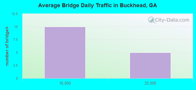
- 150,620Total average daily traffic
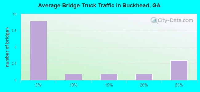
- 25,936Total average daily truck traffic
- National Bridge Inventory (NBI) Registered Bridges for Buckhead
- No street view available for this location
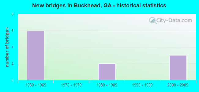
- New bridges - historical statistics
- 61960-1969
- 21980-1989
- 32000-2009
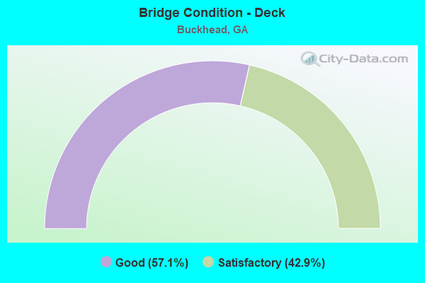
- Bridge Condition - Deck
- 57.1%Good
- 42.9%Satisfactory
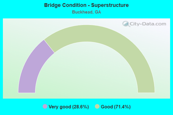
- Bridge Condition - Superstructure
- 28.6%Very good
- 71.4%Good
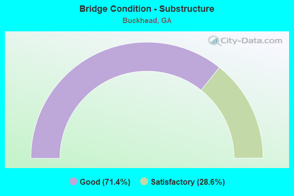
- Bridge Condition - Substructure
- 71.4%Good
- 28.6%Satisfactory
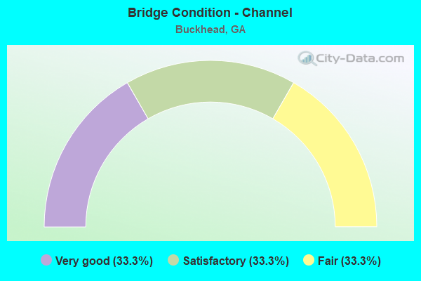
- Bridge Condition - Channel
- 33.3%Very good
- 33.3%Satisfactory
- 33.3%Fair
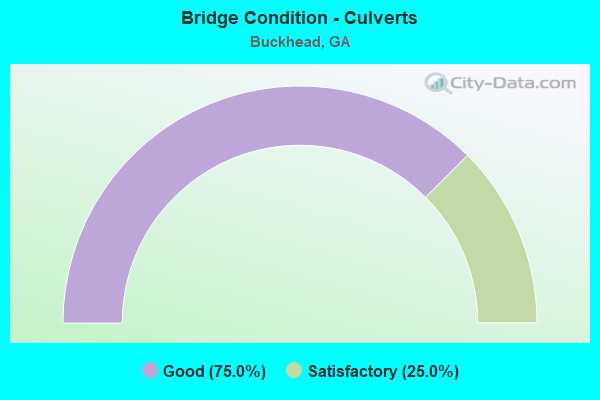
- Bridge Condition - Culverts
- 75.0%Good
- 25.0%Satisfactory
Find on map >> Show street view
Structure Number: 2110002, Location: 3 MI NE OF BUCKHEAD (Lat: 33.608739, Lng: -83.348169), Route carried "on" structure: US 278, Year Built: 1986, Status: Open, Structure Length: 16.15m (52.99ft), Average Daily Traffic: 2,320 (year 2010), Truck Traffic: 1%, Average Future Daily Traffic: 3,480 (year 2030), Design Load: HS 20+Mod, Features Intersected: APALACHEE RIVER
Minimum Vertical Clearance: 30+ m (98+ ft), Kilometerpoint: 32.187, Lanes on structure: 2, Base Highway Network: Yes, Owner: State Highway Agency, Approaching Roadway Width: 8.8m (28.9ft), Material/Design: Prestressed concrete, Design/Construction: Stringer/Multi-beam, Number Of Spans In Main Unit: 6, Length of Maximum Span: 26.8m (87.9ft), Curb-To-Curb Width: 13.4m (44.0ft), Out-to-Out Width: 14.5m (47.6ft)
Condition: Deck: Good, Superstructure: Very good, Substructure: Good, Channel: Very good, Operating Rating: 50.8 metric tons, Method Used To Determine Operating Rating: Load Factor (LF), Inventory Rating: 29.9 metric tons, Method Used To Determine Inventory Rating: Load Factor (LF), Structural Evaluation: Better than present minimum criteria, Deck Geometry: Better than present minimum criteria, Waterway Adequacy: Superior to present desirable criteria, Approach Roadway Alignment: Equal to present desirable criteria, Designated Inspection Frequency: Every 24 months, Underwater Inspection Frequency: Every 60 months, Inspection Date: August 2020, Underwater Inspection Date: August 2019, Bridge Improvement Cost: $2,071,000, Roadway Improvement Cost: $207,000, Total Project Cost: $3,106,000, Deck Structure Type: Concrete Cast-file-Place
Find on map >> Show street view
Structure Number: 2110018, Location: 3.5 MI SE OF BUCKHEAD (Lat: 33.539928, Lng: -83.315069), Route carried "on" structure: County highway 146, Year Built: 1968, Status: Open, Structure Length: 11.46m (37.60ft), Average Daily Traffic: 1,700 (year 2010), Truck Traffic: 2%, Average Future Daily Traffic: 2,550 (year 2030), Design Load: H 15, Features Intersected: I-20, Facility Carried by Structure: PARKS MILL ROAD
Minimum Vertical Clearance: 30+ m (98+ ft), Kilometerpoint: 4.828, Lanes on structure: 2, Lanes under structure: 4, Base Highway Network: Yes, Owner: State Highway Agency, Approaching Roadway Width: 7.0m (23.0ft), Skew: 4 degrees, Material/Design: Steel, Design/Construction: Stringer/Multi-beam, Number Of Spans In Main Unit: 4, Length of Maximum Span: 32.3m (106.0ft), Curb or Sidewalk Widths: Left: 0.6m (2.0ft), Right: 0.6m (2.0ft), Curb-To-Curb Width: 7.3m (24.0ft), Out-to-Out Width: 10.0m (32.8ft)
Condition: Deck: Satisfactory, Superstructure: Good, Substructure: Satisfactory, Operating Rating: 51.7 metric tons, Method Used To Determine Operating Rating: Load Factor (LF), Inventory Rating: 30.8 metric tons, Method Used To Determine Inventory Rating: Load Factor (LF), Structural Evaluation: Equal to present minimum criteria, Deck Geometry: Meets minimum limits, Underclear: Meets minimum limits, Approach Roadway Alignment: Equal to present minimum criteria, Designated Inspection Frequency: Every 24 months, Inspection Date: August 2020, Bridge Improvement Cost: $1,469,000, Roadway Improvement Cost: $147,000, Total Project Cost: $2,204,000, Deck Structure Type: Concrete Cast-file-Place
Find on map >> Show street view
Structure Number: 2110032, Location: 1.9 MI SW OF BUCKHEAD (Lat: 33.554289, Lng: -83.391569), Route carried "on" structure: Interstate 20, Year Built: 1968, Status: Open, Structure Length: 5.88m (19.29ft), Average Daily Traffic: 28,780 (year 2011), Truck Traffic: 22%, Average Future Daily Traffic: 43,170 (year 2031), Design Load: HS 20+Mod, Features Intersected: CR 214- NORTH SUGAR CRK
Minimum Vertical Clearance: 30+ m (98+ ft), Kilometerpoint: 191.512, Lanes on structure: 2, Lanes under structure: 2, Base Highway Network: Yes, Owner: State Highway Agency, Approaching Roadway Width: 13.1m (43.0ft), Skew: 12 degrees, Material/Design: Concrete, Design/Construction: Tee Beam, Number Of Spans In Main Unit: 5, Length of Maximum Span: 12.2m (40.0ft), Curb-To-Curb Width: 11.6m (38.1ft), Out-to-Out Width: 12.3m (40.4ft)
Condition: Deck: Satisfactory, Superstructure: Good, Substructure: Good, Channel: Satisfactory, Operating Rating: 31.7 metric tons, Method Used To Determine Operating Rating: Load Factor (LF), Inventory Rating: 19.0 metric tons, Method Used To Determine Inventory Rating: Load Factor (LF), Structural Evaluation: Meets minimum limits, Deck Geometry: Equal to present minimum criteria, Underclear: High priority of corrective action, Waterway Adequacy: Equal to present desirable criteria, Approach Roadway Alignment: Equal to present desirable criteria, Designated Inspection Frequency: Every 24 months, Inspection Date: August 2020, Bridge Improvement Cost: $754,000, Roadway Improvement Cost: $75,000, Total Project Cost: $1,131,000, Deck Structure Type: Concrete Cast-file-Place
Find on map >> Show street view
Structure Number: 2110033, Location: 1.9 MI SW OF BUCKHEAD (Lat: 33.554528, Lng: -83.391658), Route carried "on" structure: Interstate 20, Year Built: 1968, Status: Open, Structure Length: 5.88m (19.29ft), Average Daily Traffic: 28,780 (year 2011), Truck Traffic: 22%, Average Future Daily Traffic: 43,170 (year 2031), Design Load: HS 20+Mod, Features Intersected: CR 214- NORTH SUGAR CRK
Minimum Vertical Clearance: 30+ m (98+ ft), Kilometerpoint: 191.512, Lanes on structure: 2, Lanes under structure: 2, Base Highway Network: Yes, Owner: State Highway Agency, Approaching Roadway Width: 13.1m (43.0ft), Skew: 12 degrees, Material/Design: Concrete, Design/Construction: Tee Beam, Number Of Spans In Main Unit: 5, Length of Maximum Span: 12.2m (40.0ft), Curb-To-Curb Width: 11.6m (38.1ft), Out-to-Out Width: 12.3m (40.4ft)
Condition: Deck: Satisfactory, Superstructure: Good, Substructure: Satisfactory, Channel: Satisfactory, Operating Rating: 37.1 metric tons, Method Used To Determine Operating Rating: Load Factor (LF), Inventory Rating: 21.7 metric tons, Method Used To Determine Inventory Rating: Load Factor (LF), Structural Evaluation: Somewhat better than minimum adequacy, Deck Geometry: Equal to present minimum criteria, Underclear: Meets minimum limits, Waterway Adequacy: Equal to present desirable criteria, Approach Roadway Alignment: Equal to present desirable criteria, Designated Inspection Frequency: Every 24 months, Inspection Date: August 2020, Bridge Improvement Cost: $754,000, Roadway Improvement Cost: $75,000, Total Project Cost: $1,131,000, Deck Structure Type: Concrete Cast-file-Place
Find on map >> Show street view
Structure Number: 2110034, Location: 1.5 MI S OF BUCKHEAD (Lat: 33.548747, Lng: -83.348169), Route carried "on" structure: Interstate 20, Year Built: 1967, Status: Open, Structure Length: 0.82m (2.69ft), Average Daily Traffic: 26,170 (year 2010), Truck Traffic: 12%, Average Future Daily Traffic: 39,255 (year 2030), Design Load: HS 20+Mod, Features Intersected: SUGAR CREEK TRIB
Minimum Vertical Clearance: 30+ m (98+ ft), Kilometerpoint: 196.340, Lanes on structure: 4, Base Highway Network: Yes, Owner: State Highway Agency, Approaching Roadway Width: 26.2m (86.0ft), Skew: 13 degrees, Material/Design: Concrete, Design/Construction: Culvert, Number Of Spans In Main Unit: 3, Length of Maximum Span: 2.4m (7.9ft)
Condition: Channel: Fair, Culverts: Good, Operating Rating: 89.8 metric tons, Method Used To Determine Operating Rating: Field evaluation and documented engineering judgment, Inventory Rating: 89.8 metric tons, Method Used To Determine Inventory Rating: Field evaluation and documented engineering judgment, Structural Evaluation: Better than present minimum criteria, Waterway Adequacy: Equal to present desirable criteria, Approach Roadway Alignment: Equal to present desirable criteria, Designated Inspection Frequency: Every 24 months, Inspection Date: August 2020, Bridge Improvement Cost: $163,000, Roadway Improvement Cost: $16,000, Total Project Cost: $245,000
Find on map >> Show street view
Structure Number: 211503, Location: 2 MI SW OF BUCKHEAD (Lat: 33.555367, Lng: -83.392042), Route carried "on" structure: County highway 152, Year Built: 1967, Status: Posted for load, Structure Length: 3.29m (10.79ft), Average Daily Traffic: 600 (year 2011), Truck Traffic: 1%, Average Future Daily Traffic: 900 (year 2031), Design Load: HS 15, Features Intersected: NORTH SUGAR CREEK, Facility Carried by Structure: BALDWIN DAIRY ROAD
Minimum Vertical Clearance: 30+ m (98+ ft), Kilometerpoint: 3.219, Lanes on structure: 2, Base Highway Network: Yes, Owner: County Highway Agency, Approaching Roadway Width: 6.1m (20.0ft), Material/Design: Concrete, Design/Construction: Tee Beam, Number Of Spans In Main Unit: 3, Length of Maximum Span: 11.0m (36.1ft), Curb or Sidewalk Widths: Left: 0.6m (2.0ft), Right: 0.6m (2.0ft), Curb-To-Curb Width: 7.3m (24.0ft), Out-to-Out Width: 9.3m (30.5ft)
Condition: Deck: Good, Superstructure: Good, Substructure: Good, Channel: Fair, Operating Rating: 32.6 metric tons, Method Used To Determine Operating Rating: Load Factor (LF), Inventory Rating: 19.0 metric tons, Method Used To Determine Inventory Rating: Load Factor (LF), Structural Evaluation: Somewhat better than minimum adequacy, Deck Geometry: Meets minimum limits, Waterway Adequacy: Equal to present desirable criteria, Approach Roadway Alignment: Equal to present minimum criteria, Designated Inspection Frequency: Every 24 months, Inspection Date: September 2020, Bridge Improvement Cost: $422,000, Roadway Improvement Cost: $42,000, Total Project Cost: $633,000, Deck Structure Type: Concrete Cast-file-Place
Find on map >> Show street view
Structure Number: 2115041, Location: 2.6 MI SW OF BUCKHEAD (Lat: 33.548528, Lng: -83.399839), Route carried "on" structure: County highway 214, Year Built: 1960, Status: Open, Structure Length: 1.01m (3.31ft), Average Daily Traffic: 620 (year 2010), Truck Traffic: 1%, Average Future Daily Traffic: 930 (year 2030), Design Load: H 15, Features Intersected: SUGAR CREEK, Facility Carried by Structure: BARROWS GROVE RD
Minimum Vertical Clearance: 30+ m (98+ ft), Kilometerpoint: 1.609, Lanes on structure: 2, Base Highway Network: Yes, Owner: County Highway Agency, Approaching Roadway Width: 6.1m (20.0ft), Skew: 1 degrees, Material/Design: Concrete, Design/Construction: Culvert, Number Of Spans In Main Unit: 3, Length of Maximum Span: 3.0m (9.8ft)
Condition: Channel: Satisfactory, Culverts: Satisfactory, Operating Rating: 41.7 metric tons, Method Used To Determine Operating Rating: Field evaluation and documented engineering judgment, Inventory Rating: 24.4 metric tons, Method Used To Determine Inventory Rating: Field evaluation and documented engineering judgment, Structural Evaluation: Equal to present minimum criteria, Waterway Adequacy: Equal to present desirable criteria, Approach Roadway Alignment: Equal to present desirable criteria, Designated Inspection Frequency: Every 24 months, Inspection Date: August 2020, Bridge Improvement Cost: $129,000, Roadway Improvement Cost: $13,000, Total Project Cost: $193,000
Find on map >> Show street view
Structure Number: 2115049, Location: 5.6 MI NE OF MADISON (Lat: 33.621008, Lng: -83.377378), Route carried "on" structure: County highway 167, Year Built: 1986, Status: Open, Structure Length: 0.82m (2.69ft), Average Daily Traffic: 100 (year 2010), Truck Traffic: 1%, Average Future Daily Traffic: 150 (year 2030), Design Load: H 15, Features Intersected: BRIAR CREEK, Facility Carried by Structure: BRIAR CREEK ROAD
Minimum Vertical Clearance: 30+ m (98+ ft), Kilometerpoint: 1.609, Lanes on structure: 2, Owner: County Highway Agency, Approaching Roadway Width: 4.9m (16.1ft), Material/Design: Steel, Design/Construction: Culvert, Number Of Spans In Main Unit: 3, Length of Maximum Span: 2.1m (6.9ft)
Condition: Channel: Fair, Culverts: Good, Operating Rating: 41.7 metric tons, Method Used To Determine Operating Rating: Field evaluation and documented engineering judgment, Inventory Rating: 24.4 metric tons, Method Used To Determine Inventory Rating: Field evaluation and documented engineering judgment, Structural Evaluation: Equal to present minimum criteria, Waterway Adequacy: Equal to present desirable criteria, Approach Roadway Alignment: Equal to present desirable criteria, Designated Inspection Frequency: Every 24 months, Inspection Date: August 2020, Bridge Improvement Cost: $105,000, Roadway Improvement Cost: $11,000, Total Project Cost: $158,000
Find on map >> Show street view
Structure Number: 211506, Location: 1.8 MI S OF BUCKHEAD (Lat: 33.542097, Lng: -83.360339), Route carried "on" structure: County highway 2156, Year Built: 2002, Status: Open, Structure Length: 6.55m (21.49ft), Average Daily Traffic: 560 (year 2011), Truck Traffic: 1%, Average Future Daily Traffic: 840 (year 2031), Design Load: HS 20+Mod, Features Intersected: SUGAR CREEK, Facility Carried by Structure: SEVEN ISLANDS RD
Minimum Vertical Clearance: 30+ m (98+ ft), Kilometerpoint: 22.531, Lanes on structure: 2, Base Highway Network: Yes, Owner: County Highway Agency, Approaching Roadway Width: 6.4m (21.0ft), Skew: 4 degrees, Material/Design: Prestressed concrete, Design/Construction: Stringer/Multi-beam, Number Of Spans In Main Unit: 3, Length of Maximum Span: 32.0m (105.0ft), Curb-To-Curb Width: 9.8m (32.2ft), Out-to-Out Width: 10.8m (35.4ft)
Condition: Deck: Good, Superstructure: Very good, Substructure: Good, Channel: Very good, Operating Rating: 71.6 metric tons, Method Used To Determine Operating Rating: Allowable Stress (AS), Inventory Rating: 30.8 metric tons, Method Used To Determine Inventory Rating: Allowable Stress (AS), Structural Evaluation: Better than present minimum criteria, Deck Geometry: Equal to present minimum criteria, Waterway Adequacy: Equal to present desirable criteria, Approach Roadway Alignment: Equal to present desirable criteria, Designated Inspection Frequency: Every 24 months, Inspection Date: August 2020, Bridge Improvement Cost: $840,000, Roadway Improvement Cost: $84,000, Total Project Cost: $1,260,000, Deck Structure Type: Concrete Cast-file-Place
Find on map >> Show street view
Structure Number: 2115065, Location: 1.2 MI S OF BUCKHEAD (Lat: 33.551319, Lng: -83.357847), Route carried "on" structure: County highway 2156, Year Built: 2003, Status: Open, Structure Length: 7.62m (25.00ft), Average Daily Traffic: 1,950 (year 2010), Truck Traffic: 5%, Average Future Daily Traffic: 2,925 (year 2030), Design Load: HS 20+Mod, Features Intersected: I-20, Facility Carried by Structure: SEVEN ISLAND ROAD
Minimum Vertical Clearance: 30+ m (98+ ft), Kilometerpoint: 24.140, Lanes on structure: 2, Lanes under structure: 4, Base Highway Network: Yes, Owner: State Highway Agency, Approaching Roadway Width: 6.4m (21.0ft), Skew: 3 degrees, Material/Design: Prestressed concrete, Design/Construction: Stringer/Multi-beam, Number Of Spans In Main Unit: 2, Length of Maximum Span: 39.0m (128.0ft), Curb-To-Curb Width: 19.6m (64.3ft), Out-to-Out Width: 20.8m (68.2ft)
Condition: Deck: Good, Superstructure: Good, Substructure: Good, Operating Rating: 23.5 metric tons, Method Used To Determine Operating Rating: Load Factor (LF), Inventory Rating: 13.6 metric tons, Method Used To Determine Inventory Rating: Load Factor (LF), Structural Evaluation: Meets minimum limits, Deck Geometry: Superior to present desirable criteria, Underclear: Equal to present desirable criteria, Approach Roadway Alignment: Equal to present desirable criteria, Designated Inspection Frequency: Every 24 months, Inspection Date: August 2020, Bridge Improvement Cost: $977,000, Roadway Improvement Cost: $98,000, Total Project Cost: $1,465,000, Deck Structure Type: Concrete Cast-file-Place
Find on map >> Show street view
Structure Number: 2115069, Location: 2 MI N OF BUCKHEAD (Lat: 33.596778, Lng: -83.357458), Route carried "on" structure: County highway 164, Year Built: 2004, Status: Open, Structure Length: 0.98m (3.22ft), Average Daily Traffic: 1,400 (year 2010), Truck Traffic: 1%, Average Future Daily Traffic: 2,100 (year 2030), Design Load: HS 20+Mod, Features Intersected: GOOSE CREEK, Facility Carried by Structure: APALACHEE RIVER RD
Minimum Vertical Clearance: 30+ m (98+ ft), Kilometerpoint: 3.219, Lanes on structure: 2, Base Highway Network: Yes, Owner: County Highway Agency, Approaching Roadway Width: 6.1m (20.0ft), Material/Design: Concrete, Design/Construction: Culvert, Number Of Spans In Main Unit: 3, Length of Maximum Span: 3.0m (9.8ft)
Condition: Channel: Very good, Culverts: Good, Operating Rating: 55.3 metric tons, Method Used To Determine Operating Rating: Field evaluation and documented engineering judgment, Inventory Rating: 32.6 metric tons, Method Used To Determine Inventory Rating: Field evaluation and documented engineering judgment, Structural Evaluation: Better than present minimum criteria, Waterway Adequacy: Equal to present desirable criteria, Approach Roadway Alignment: Equal to present desirable criteria, Designated Inspection Frequency: Every 24 months, Inspection Date: August 2020, Bridge Improvement Cost: $125,000, Roadway Improvement Cost: $13,000, Total Project Cost: $188,000
Find on map >> Show street view
Structure Number: 2110018, Location: 3.5 MI SE OF BUCKHEAD (Lat: 33.539928, Lng: -83.315069), Route carried "under" structure: Interstate 20, Structure Length: 0. m, Average Daily Traffic: 28,400 (year 2010), Truck Traffic: 15%, Features Intersected: CR 146 PARKS MILL ROAD, Facility Carried by Structure: PARKS MILL ROAD
Minimum Vertical Clearance: 5.48m (17.98ft), Kilometerpoint: 199.559, Lanes on structure: 2, Length of Maximum Span: 0.0m
Find on map >> Show street view
Structure Number: 2110032, Location: 1.9 MI SW OF BUCKHEAD (Lat: 33.554289, Lng: -83.391569), Route carried "under" structure: ServiceCounty highway 214, Structure Length: 0. m, Average Daily Traffic: 420 (year 2010), Truck Traffic: 1%, Features Intersected: I-20 EBL, Facility Carried by Structure: I-20 EBL
Minimum Vertical Clearance: 4.21m (13.81ft), Kilometerpoint: 3.219, Lanes on structure: 2, Length of Maximum Span: 0.0m
Find on map >> Show street view
Structure Number: 2110033, Location: 1.9 MI SW OF BUCKHEAD (Lat: 33.554528, Lng: -83.391658), Route carried "under" structure: ServiceCounty highway 214, Structure Length: 0. m, Average Daily Traffic: 420 (year 2010), Truck Traffic: 1%, Features Intersected: I-20 WBL, Facility Carried by Structure: I-20 WBL
Minimum Vertical Clearance: 4.52m (14.83ft), Kilometerpoint: 3.219, Lanes on structure: 2, Length of Maximum Span: 0.0m
Find on map >> Show street view
Structure Number: 2115065, Location: 1.2 MI S OF BUCKHEAD (Lat: 33.551319, Lng: -83.357847), Route carried "under" structure: Interstate 20, Structure Length: 0. m, Average Daily Traffic: 28,400 (year 2010), Truck Traffic: 20%, Features Intersected: CR 251 SEVEN ISLAND RD, Facility Carried by Structure: SEVEN ISLAND ROAD
Minimum Vertical Clearance: 5.66m (18.57ft), Kilometerpoint: 194.731, Lanes on structure: 2, Length of Maximum Span: 0.0m