Bridge Statistics for Burnside, Kentucky (KY)
Condition, Traffic, Stress, Structural Evaluation, Project Costs
- National Bridge Inventory (NBI) Statistics
- 27Number of bridges
- 1,122ft / 342mTotal length
- $46,940,000Total costs
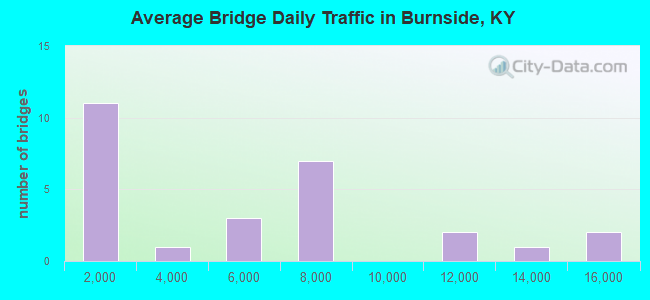
- 138,803Total average daily traffic
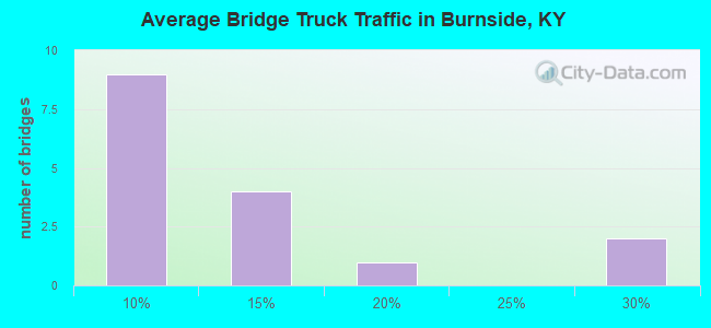
- 13,621Total average daily truck traffic
- National Bridge Inventory (NBI) Registered Bridges for Burnside
- No street view available for this location
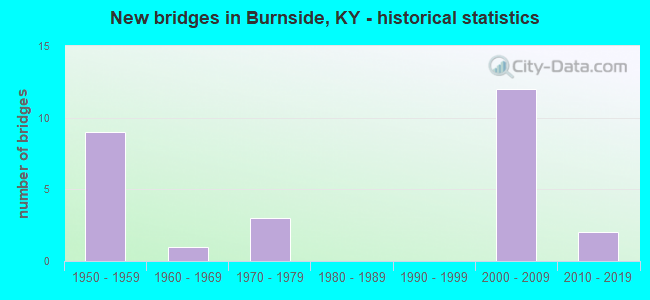
- New bridges - historical statistics
- 91950-1959
- 11960-1969
- 31970-1979
- 122000-2009
- 22010-2019
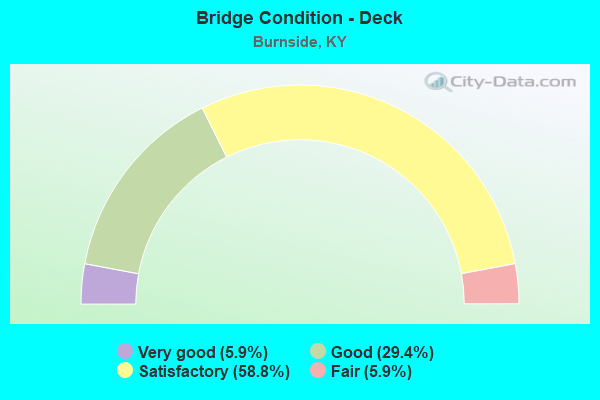
- Bridge Condition - Deck
- 5.9%Very good
- 29.4%Good
- 58.8%Satisfactory
- 5.9%Fair
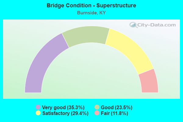
- Bridge Condition - Superstructure
- 35.3%Very good
- 23.5%Good
- 29.4%Satisfactory
- 11.8%Fair
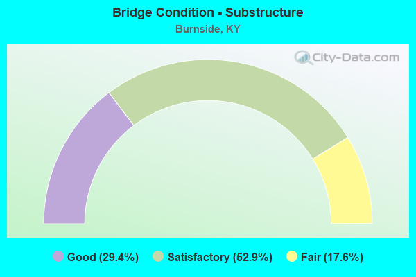
- Bridge Condition - Substructure
- 29.4%Good
- 52.9%Satisfactory
- 17.6%Fair
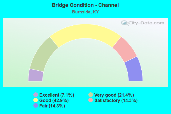
- Bridge Condition - Channel
- 7.1%Excellent
- 21.4%Very good
- 42.9%Good
- 14.3%Satisfactory
- 14.3%Fair
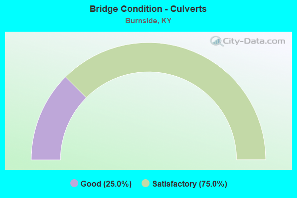
- Bridge Condition - Culverts
- 25.0%Good
- 75.0%Satisfactory
Find on map >> Show street view
Structure Number: 100B00029N, Location: 2.4 MI W OF E-JCT KY 1248 (Lat: 37.051667, Lng: -84.678611), Route carried "on" structure: State highway 80, Year Built: 1951, Status: Posted for load, Structure Length: 36.83m (120.83ft), Average Daily Traffic: 5,942 (year 2018), Truck Traffic: 15%, Average Future Daily Traffic: 5,228 (year 2038), Design Load: H 20, Features Intersected: Fishing Creek
Minimum Vertical Clearance: 30+ m (98+ ft), Kilometerpoint: 22.228, Lanes on structure: 2, Owner: State Highway Agency, Approaching Roadway Width: 6.4m (21.0ft), Material/Design: Steel, Design/Construction: Truss - Deck, Number Of Spans In Main Unit: 3, Number Of Approach Spans: 2, Length of Maximum Span: 110.6m (362.9ft), Curb or Sidewalk Widths: Left: 0.4m (1.3ft), Right: 0.4m (1.3ft), Curb-To-Curb Width: 7.8m (25.6ft), Out-to-Out Width: 9.2m (30.2ft)
Condition: Deck: Fair, Superstructure: Fair, Substructure: Fair, Channel: Good, Operating Rating: 32.4 metric tons, Method Used To Determine Operating Rating: Load Factor (LF), Inventory Rating: 19.4 metric tons, Method Used To Determine Inventory Rating: Load Factor (LF), Structural Evaluation: Meets minimum limits, Deck Geometry: High priority of replacement, Waterway Adequacy: Superior to present desirable criteria, Approach Roadway Alignment: Equal to present desirable criteria, Bridge Posting: Required (Relationship of Operating Rating to Maximum Legal Load: > 39.9% below), Length Of Structure Improvement: 3.68m (12.07ft), Designated Inspection Frequency: Every 12 months, Critical Feature Inspection Frequency: Every 24 months, Underwater Inspection Frequency: Every 60 months, Inspection Date: July 2021, Critical Feature Inspection Date: July 2021, Underwater Inspection Date: November 2020, Bridge Improvement Cost: $4,983,000, Total Project Cost: $4,983,000, Deck Structure Type: Concrete Cast-file-Place, Wearing Surface/Protective System: Wearing Surface: Low Slump Concrete
Find on map >> Show street view
Structure Number: 100B00032R, Location: .25 MI NOR. OF JCT KY 90- (Lat: 37.004444, Lng: -84.614722), Route carried "on" structure: US 27, Year Built: 1950, Status: Posted for load, Structure Length: 21.55m (70.70ft), Average Daily Traffic: 7,059 (year 2020), Truck Traffic: 8%, Average Future Daily Traffic: 6,635 (year 2040), Design Load: H 20, Features Intersected: PITMAN CREEK
Minimum Vertical Clearance: 30+ m (98+ ft), Kilometerpoint: 16.304, Lanes on structure: 2, Base Highway Network: Yes, Owner: State Highway Agency, Approaching Roadway Width: 12.8m (42.0ft), Material/Design: Steel continuous, Design/Construction: Truss - Deck, Number Of Spans In Main Unit: 3, Length of Maximum Span: 91.4m (299.9ft), Curb-To-Curb Width: 9.8m (32.2ft), Out-to-Out Width: 10.8m (35.4ft)
Condition: Deck: Good, Superstructure: Fair, Substructure: Fair, Channel: Good, Operating Rating: 40.8 metric tons, Method Used To Determine Operating Rating: Load Factor (LF), Inventory Rating: 27.4 metric tons, Method Used To Determine Inventory Rating: Load Factor (LF), Structural Evaluation: Somewhat better than minimum adequacy, Deck Geometry: Meets minimum limits, Waterway Adequacy: Superior to present desirable criteria, Approach Roadway Alignment: Equal to present desirable criteria, Bridge Posting: Required (Relationship of Operating Rating to Maximum Legal Load: 20.0 - 29.9% below), Length Of Structure Improvement: 2.14m (7.02ft), Designated Inspection Frequency: Every 24 months, Critical Feature Inspection Frequency: Every 24 months, Underwater Inspection Frequency: Every 60 months, Inspection Date: April 2021, Critical Feature Inspection Date: April 2021, Underwater Inspection Date: November 2020, Bridge Improvement Cost: $3,754,000, Roadway Improvement Cost: $1,000,000, Total Project Cost: $4,754,000, Deck Structure Type: Other, Wearing Surface/Protective System: Wearing Surface: Latex Concrete, Deck Protection: Other
Find on map >> Show street view
Structure Number: 100B00057N, Location: 1.9 MI S.W. OF JCT KY-235 (Lat: 37.035000, Lng: -84.756944), Route carried "on" structure: State highway 761, Year Built: 1952, Status: Open, Structure Length: 1.41m (4.63ft), Average Daily Traffic: 943 (year 2019), Average Future Daily Traffic: 829 (year 2039), Design Load: H 15, Features Intersected: WHITE OAK CREEK
Minimum Vertical Clearance: 30+ m (98+ ft), Kilometerpoint: 7.912, Lanes on structure: 2, Owner: State Highway Agency, Approaching Roadway Width: 5.2m (17.1ft), Skew: 3 degrees, Material/Design: Concrete, Design/Construction: Culvert, Number Of Spans In Main Unit: 3, Length of Maximum Span: 4.2m (13.8ft), Curb or Sidewalk Widths: Left: 0.3m (1.0ft), Right: 0.3m (1.0ft), Out-to-Out Width: 7.1m (23.3ft)
Condition: Channel: Satisfactory, Culverts: Satisfactory, Operating Rating: 54.4 metric tons, Method Used To Determine Operating Rating: Field evaluation and documented engineering judgment, Inventory Rating: 40.8 metric tons, Method Used To Determine Inventory Rating: Field evaluation and documented engineering judgment, Structural Evaluation: Equal to present minimum criteria, Waterway Adequacy: Equal to present minimum criteria, Approach Roadway Alignment: Somewhat better than minimum adequacy, Length Of Structure Improvement: 0.14m (0.46ft), Designated Inspection Frequency: Every 24 months, Inspection Date: July 2020, Bridge Improvement Cost: $115,000, Total Project Cost: $115,000
Find on map >> Show street view
Structure Number: 100B00058N, Location: 2.5 MI S.W. OF JCT KY-235 (Lat: 37.029167, Lng: -84.759167), Route carried "on" structure: State highway 761, Year Built: 1952, Status: Open, Structure Length: 0.88m (2.89ft), Average Daily Traffic: 943 (year 2019), Average Future Daily Traffic: 829 (year 2039), Design Load: H 15, Features Intersected: SPUTTER BRANCH
Minimum Vertical Clearance: 30+ m (98+ ft), Kilometerpoint: 7.084, Lanes on structure: 2, Owner: State Highway Agency, Approaching Roadway Width: 5.2m (17.1ft), Material/Design: Concrete, Design/Construction: Culvert, Number Of Spans In Main Unit: 2, Length of Maximum Span: 4.3m (14.1ft), Curb-To-Curb Width: 6.4m (21.0ft), Out-to-Out Width: 7.3m (24.0ft)
Condition: Channel: Fair, Culverts: Satisfactory, Operating Rating: 54.4 metric tons, Method Used To Determine Operating Rating: Field evaluation and documented engineering judgment, Inventory Rating: 40.8 metric tons, Method Used To Determine Inventory Rating: Field evaluation and documented engineering judgment, Structural Evaluation: Equal to present minimum criteria, Deck Geometry: High priority of corrective action, Waterway Adequacy: Better than present minimum criteria, Approach Roadway Alignment: Somewhat better than minimum adequacy, Length Of Structure Improvement: 0.09m (0.30ft), Designated Inspection Frequency: Every 24 months, Inspection Date: July 2020, Bridge Improvement Cost: $78,000, Total Project Cost: $77,000
Find on map >> Show street view
Structure Number: 100B00074L, Location: WBL 4.0 MI W OF JCT US 27 (Lat: 37.097500, Lng: -84.691389), Route carried "on" structure: State highway 9008, Year Built: 1973, Status: Posted for load, Structure Length: 53.22m (174.61ft), Average Daily Traffic: 4,192 (year 2020), Truck Traffic: 28%, Average Future Daily Traffic: 3,940 (year 2040), Design Load: HS 20+Mod, Features Intersected: FISHING CREEK, Facility Carried by Structure: LOUIE B. NUNN CUMB
Minimum Vertical Clearance: 30+ m (98+ ft), Kilometerpoint: 135.935, Lanes on structure: 2, Base Highway Network: Yes, Owner: State Highway Agency, Approaching Roadway Width: 12.8m (42.0ft), Material/Design: Steel continuous, Design/Construction: Stringer/Multi-beam, Number Of Spans In Main Unit: 11, Length of Maximum Span: 83.8m (274.9ft), Curb or Sidewalk Widths: Left: 0.2m (0.7ft), Right: 0.2m (0.7ft), Curb-To-Curb Width: 9.1m (29.9ft), Out-to-Out Width: 9.9m (32.5ft)
Condition: Deck: Satisfactory, Superstructure: Satisfactory, Substructure: Satisfactory, Channel: Good, Operating Rating: 35.2 metric tons, Method Used To Determine Operating Rating: Load Factor (LF), Inventory Rating: 21.1 metric tons, Method Used To Determine Inventory Rating: Load Factor (LF), Structural Evaluation: Somewhat better than minimum adequacy, Deck Geometry: Meets minimum limits, Waterway Adequacy: Superior to present desirable criteria, Approach Roadway Alignment: Equal to present desirable criteria, Bridge Posting: Required (Relationship of Operating Rating to Maximum Legal Load: 20.0 - 29.9% below), Designated Inspection Frequency: Every 24 months, Critical Feature Inspection Frequency: Every 24 months, Underwater Inspection Frequency: Every 60 months, Inspection Date: August 2021, Critical Feature Inspection Date: August 2021, Underwater Inspection Date: November 2020, Deck Structure Type: Concrete Cast-file-Place, Wearing Surface/Protective System: Wearing Surface: Latex Concrete
Find on map >> Show street view
Structure Number: 100B00074R, Location: EBL 4.0 MI W OF JCT US 27 (Lat: 37.097500, Lng: -84.691389), Route carried "on" structure: State highway 9008, Year Built: 1973, Status: Posted for load, Structure Length: 53.22m (174.61ft), Average Daily Traffic: 4,192 (year 2020), Truck Traffic: 28%, Average Future Daily Traffic: 3,940 (year 2040), Design Load: HS 20+Mod, Features Intersected: FISHING CREEK
Minimum Vertical Clearance: 30+ m (98+ ft), Kilometerpoint: 135.943, Lanes on structure: 2, Base Highway Network: Yes, Owner: State Highway Agency, Approaching Roadway Width: 12.8m (42.0ft), Material/Design: Steel continuous, Design/Construction: Girder and Floorbeam System, Number Of Spans In Main Unit: 11, Length of Maximum Span: 83.8m (274.9ft), Curb or Sidewalk Widths: Left: 0.2m (0.7ft), Right: 0.2m (0.7ft), Curb-To-Curb Width: 9.1m (29.9ft), Out-to-Out Width: 10.2m (33.5ft)
Condition: Deck: Satisfactory, Superstructure: Satisfactory, Substructure: Satisfactory, Channel: Good, Operating Rating: 35.2 metric tons, Method Used To Determine Operating Rating: Load Factor (LF), Inventory Rating: 21.1 metric tons, Method Used To Determine Inventory Rating: Load Factor (LF), Structural Evaluation: Somewhat better than minimum adequacy, Deck Geometry: Meets minimum limits, Waterway Adequacy: Superior to present desirable criteria, Approach Roadway Alignment: Equal to present desirable criteria, Bridge Posting: Required (Relationship of Operating Rating to Maximum Legal Load: 20.0 - 29.9% below), Designated Inspection Frequency: Every 24 months, Critical Feature Inspection Frequency: Every 24 months, Underwater Inspection Frequency: Every 60 months, Inspection Date: August 2021, Critical Feature Inspection Date: August 2021, Underwater Inspection Date: November 2020, Deck Structure Type: Concrete Cast-file-Place, Wearing Surface/Protective System: Wearing Surface: Latex Concrete
Find on map >> Show street view
Structure Number: 100B00091N, Location: 0.9 MILE NW OF US 27 (Lat: 36.941389, Lng: -84.579722), Route carried "on" structure: State highway 804, Year Built: 1962, Status: Posted for load, Structure Length: 6.34m (20.80ft), Average Daily Traffic: 779 (year 2019), Average Future Daily Traffic: 677 (year 2039), Design Load: H 15, Features Intersected: NS (CNO&TP) SYSTEM
Minimum Vertical Clearance: 30+ m (98+ ft), Kilometerpoint: 3.597, Lanes on structure: 2, Owner: State Highway Agency, Approaching Roadway Width: 5.5m (18.0ft), Skew: 4 degrees, Material/Design: Steel continuous, Design/Construction: Frame, Number Of Spans In Main Unit: 3, Length of Maximum Span: 27.4m (89.9ft), Curb or Sidewalk Widths: Left: 0.2m (0.7ft), Right: 0.2m (0.7ft), Curb-To-Curb Width: 6.7m (22.0ft), Out-to-Out Width: 7.3m (24.0ft)
Condition: Deck: Satisfactory, Superstructure: Satisfactory, Substructure: Fair, Operating Rating: 11.0 metric tons, Method Used To Determine Operating Rating: Load and Resistance Factor Rating (LRFR) rating reported by rating factor(RF) method using HL-93 loadings, Inventory Rating: 8.4 metric tons, Method Used To Determine Inventory Rating: Load and Resistance Factor Rating (LRFR) rating reported by rating factor(RF) method using HL-93 loadings, Structural Evaluation: High priority of corrective action, Deck Geometry: Meets minimum limits, Approach Roadway Alignment: Equal to present minimum criteria, Bridge Posting: Required (Relationship of Operating Rating to Maximum Legal Load: 30.0 - 39.9% below), Designated Inspection Frequency: Every 24 months, Inspection Date: July 2020, Deck Structure Type: Concrete Cast-file-Place, Wearing Surface/Protective System: Wearing Surface: Latex Concrete
Find on map >> Show street view
Structure Number: 100B00107L, Location: .25 MI NORTH OF JCT KY 90 (Lat: 37.004444, Lng: -84.614722), Route carried "on" structure: US 27, Year Built: 2000, Status: Open, Structure Length: 23.71m (77.79ft), Average Daily Traffic: 7,059 (year 2020), Truck Traffic: 8%, Average Future Daily Traffic: 6,635 (year 2040), Design Load: HS 25 or greater, Features Intersected: PITTMAN CREEK @ CUMBERL
Minimum Vertical Clearance: 30+ m (98+ ft), Kilometerpoint: 16.304, Lanes on structure: 2, Base Highway Network: Yes, Owner: State Highway Agency, Approaching Roadway Width: 12.8m (42.0ft), Material/Design: Steel continuous, Design/Construction: Stringer/Multi-beam, Number Of Spans In Main Unit: 3, Length of Maximum Span: 92.0m (301.8ft), Curb-To-Curb Width: 11.9m (39.0ft), Out-to-Out Width: 13.1m (43.0ft)
Condition: Deck: Satisfactory, Superstructure: Good, Substructure: Good, Channel: Very good, Operating Rating: 53.0 metric tons, Method Used To Determine Operating Rating: Load Factor (LF), Inventory Rating: 31.8 metric tons, Method Used To Determine Inventory Rating: Load Factor (LF), Structural Evaluation: Better than present minimum criteria, Deck Geometry: Better than present minimum criteria, Waterway Adequacy: Superior to present desirable criteria, Approach Roadway Alignment: Equal to present desirable criteria, Designated Inspection Frequency: Every 24 months, Underwater Inspection Frequency: Every 60 months, Inspection Date: July 2020, Underwater Inspection Date: November 2020, Deck Structure Type: Concrete Cast-file-Place, Wearing Surface/Protective System: Wearing Surface: Monolithic Concrete, Deck Protection: Epoxy Coated Reinforcing
Find on map >> Show street view
Structure Number: 100B00108N, Location: 0.4 MILES S. OF JCT KY 90 (Lat: 36.995556, Lng: -84.606667), Route carried "on" structure: US 27, Year Built: 2001, Status: Open, Structure Length: 42.87m (140.65ft), Average Daily Traffic: 13,473 (year 2015), Truck Traffic: 8%, Average Future Daily Traffic: 12,664 (year 2035), Design Load: HS 25 or greater, Features Intersected: CUMBERLAND RIVER
Minimum Vertical Clearance: 30+ m (98+ ft), Kilometerpoint: 15.022, Lanes on structure: 4, Lanes under structure: 2, Base Highway Network: Yes, Owner: State Highway Agency, Approaching Roadway Width: 24.0m (78.7ft), Skew: 30 degrees, Material/Design: Steel continuous, Design/Construction: Stringer/Multi-beam, Number Of Spans In Main Unit: 5, Number Of Approach Spans: 2, Length of Maximum Span: 84.0m (275.6ft), Curb-To-Curb Width: 24.0m (78.7ft), Out-to-Out Width: 25.8m (84.6ft)
Condition: Deck: Satisfactory, Superstructure: Good, Substructure: Satisfactory, Channel: Very good, Operating Rating: 60.7 metric tons, Method Used To Determine Operating Rating: Load Factor (LF), Inventory Rating: 36.4 metric tons, Method Used To Determine Inventory Rating: Load Factor (LF), Structural Evaluation: Equal to present minimum criteria, Deck Geometry: Superior to present desirable criteria, Underclear: Meets minimum limits, Waterway Adequacy: Superior to present desirable criteria, Approach Roadway Alignment: Equal to present desirable criteria, Designated Inspection Frequency: Every 24 months, Underwater Inspection Frequency: Every 60 months, Inspection Date: July 2020, Underwater Inspection Date: January 2019, Bridge Improvement Cost: $37,011,000, Total Project Cost: $37,011,000, Deck Structure Type: Concrete Cast-file-Place, Wearing Surface/Protective System: Wearing Surface: Monolithic Concrete, Deck Protection: Epoxy Coated Reinforcing
Find on map >> Show street view
Structure Number: 100B00110N, Location: 0.8 MI. W. OF JCT US 27 (Lat: 36.990556, Lng: -84.619444), Route carried "on" structure: State highway 90, Year Built: 2005, Status: Open, Structure Length: 52.17m (171.16ft), Average Daily Traffic: 10,906 (year 2020), Truck Traffic: 10%, Average Future Daily Traffic: 10,142 (year 2040), Design Load: HS 25 or greater, Features Intersected: CUMBERLAND RIVER
Minimum Vertical Clearance: 5.49m (18.01ft), Kilometerpoint: 5.187, Lanes on structure: 4, Owner: State Highway Agency, Approaching Roadway Width: 12.2m (40.0ft), Material/Design: Steel continuous, Design/Construction: Truss - Thru, Number Of Spans In Main Unit: 2, Number Of Approach Spans: 2, Length of Maximum Span: 239.6m (786.1ft), Curb-To-Curb Width: 24.4m (80.1ft), Out-to-Out Width: 26.1m (85.6ft)
Condition: Deck: Satisfactory, Superstructure: Satisfactory, Substructure: Satisfactory, Channel: Very good, Operating Rating: 44.7 metric tons, Method Used To Determine Operating Rating: Load Factor (LF), Inventory Rating: 26.8 metric tons, Method Used To Determine Inventory Rating: Load Factor (LF), Structural Evaluation: Equal to present minimum criteria, Deck Geometry: Superior to present desirable criteria, Waterway Adequacy: Superior to present desirable criteria, Approach Roadway Alignment: Superior to present desirable criteria, Designated Inspection Frequency: Every 24 months, Critical Feature Inspection Frequency: Every 24 months, Underwater Inspection Frequency: Every 60 months, Inspection Date: June 2020, Critical Feature Inspection Date: June 2020, Underwater Inspection Date: November 2020, Deck Structure Type: Concrete Cast-file-Place, Wearing Surface/Protective System: Wearing Surface: Monolithic Concrete, Deck Protection: Epoxy Coated Reinforcing
Find on map >> Show street view
Structure Number: 100B00112N, Location: .450 MI. N. OF JCT US 27 (Lat: 37.005000, Lng: -84.602778), Route carried "on" structure: State highway 1247, Year Built: 2009, Status: Open, Structure Length: 5.95m (19.52ft), Average Daily Traffic: 7,528 (year 2019), Truck Traffic: 11%, Average Future Daily Traffic: 7,001 (year 2039), Design Load: HS 25 or greater, Features Intersected: OLD COOPER PP RD
Minimum Vertical Clearance: 30+ m (98+ ft), Kilometerpoint: 0.805, Lanes on structure: 4, Lanes under structure: 2, Owner: State Highway Agency, Approaching Roadway Width: 18.9m (62.0ft), Skew: 2 degrees, Material/Design: Prestressed concrete continuous, Design/Construction: Stringer/Multi-beam, Number Of Spans In Main Unit: 3, Length of Maximum Span: 27.1m (88.9ft), Curb-To-Curb Width: 26.2m (86.0ft), Out-to-Out Width: 27.4m (89.9ft)
Condition: Deck: Good, Superstructure: Very good, Substructure: Good, Operating Rating: 61.3 metric tons, Method Used To Determine Operating Rating: Load Factor (LF), Inventory Rating: 36.7 metric tons, Method Used To Determine Inventory Rating: Load Factor (LF), Structural Evaluation: Better than present minimum criteria, Deck Geometry: Superior to present desirable criteria, Underclear: Equal to present minimum criteria, Approach Roadway Alignment: Equal to present desirable criteria, Designated Inspection Frequency: Every 24 months, Inspection Date: July 2020, Deck Structure Type: Concrete Cast-file-Place, Wearing Surface/Protective System: Wearing Surface: Monolithic Concrete, Deck Protection: Epoxy Coated Reinforcing
Find on map >> Show street view
Structure Number: 100B00115N, Location: @ JCT KY 90 & US 27 (Lat: 37.000556, Lng: -84.609722), Route carried "on" structure: State highway 90, Year Built: 2008, Status: Open, Structure Length: 9.99m (32.78ft), Average Daily Traffic: 10,906 (year 2020), Truck Traffic: 10%, Average Future Daily Traffic: 10,142 (year 2040), Design Load: HS 25 or greater, Features Intersected: US 27 & KY 1247
Minimum Vertical Clearance: 30+ m (98+ ft), Kilometerpoint: 6.624, Lanes on structure: 4, Lanes under structure: 4, Owner: State Highway Agency, Approaching Roadway Width: 28.7m (94.2ft), Skew: 3 degrees, Material/Design: Prestressed concrete continuous, Design/Construction: Stringer/Multi-beam, Number Of Spans In Main Unit: 4, Length of Maximum Span: 34.4m (112.9ft), Curb-To-Curb Width: 28.7m (94.2ft), Out-to-Out Width: 29.6m (97.1ft)
Condition: Deck: Satisfactory, Superstructure: Very good, Substructure: Satisfactory, Operating Rating: 70.5 metric tons, Method Used To Determine Operating Rating: Load Factor (LF), Inventory Rating: 42.3 metric tons, Method Used To Determine Inventory Rating: Load Factor (LF), Structural Evaluation: Equal to present minimum criteria, Deck Geometry: Superior to present desirable criteria, Underclear: Equal to present minimum criteria, Approach Roadway Alignment: Equal to present minimum criteria, Designated Inspection Frequency: Every 24 months, Inspection Date: July 2020, Deck Structure Type: Concrete Cast-file-Place, Wearing Surface/Protective System: Wearing Surface: Monolithic Concrete, Deck Protection: Epoxy Coated Reinforcing
Find on map >> Show street view
Structure Number: 100B00116L, Location: SBL KY1247 EXIT RAMP B (Lat: 36.999722, Lng: -84.608056), Route carried "on" structure: Ramp US 27, Year Built: 2008, Status: Open, Structure Length: 7.28m (23.88ft), Average Daily Traffic: 6,737 (year 2015), Truck Traffic: 8%, Average Future Daily Traffic: 6,332 (year 2035), Design Load: HS 25 or greater, Features Intersected: NS (CNO & TP ) RR
Minimum Vertical Clearance: 30+ m (98+ ft), Kilometerpoint: 15.514, Lanes on structure: 2, Owner: State Highway Agency, Approaching Roadway Width: 7.0m (23.0ft), Skew: 4 degrees, Material/Design: Prestressed concrete continuous, Design/Construction: Stringer/Multi-beam, Number Of Spans In Main Unit: 3, Length of Maximum Span: 27.6m (90.6ft), Curb-To-Curb Width: 7.0m (23.0ft), Out-to-Out Width: 7.8m (25.6ft)
Condition: Deck: Good, Superstructure: Very good, Substructure: Good, Operating Rating: 81.9 metric tons, Method Used To Determine Operating Rating: Load Factor (LF), Inventory Rating: 49.2 metric tons, Method Used To Determine Inventory Rating: Load Factor (LF), Structural Evaluation: Better than present minimum criteria, Deck Geometry: High priority of replacement, Underclear: Superior to present desirable criteria, Approach Roadway Alignment: Equal to present minimum criteria, Designated Inspection Frequency: Every 24 months, Inspection Date: July 2020, Deck Structure Type: Concrete Cast-file-Place, Wearing Surface/Protective System: Wearing Surface: Monolithic Concrete, Deck Protection: Epoxy Coated Reinforcing
Find on map >> Show street view
Structure Number: 100B00116R, Location: NBL US 27 EXIT RAMP A (Lat: 36.999722, Lng: -84.607778), Route carried "on" structure: Ramp US 27, Year Built: 2008, Status: Open, Structure Length: 7.28m (23.88ft), Average Daily Traffic: 6,737 (year 2015), Truck Traffic: 8%, Average Future Daily Traffic: 6,332 (year 2035), Design Load: HS 25 or greater, Features Intersected: NS (CNO & TP ) RR
Minimum Vertical Clearance: 30+ m (98+ ft), Kilometerpoint: 15.508, Lanes on structure: 2, Owner: State Highway Agency, Approaching Roadway Width: 7.0m (23.0ft), Skew: 4 degrees, Material/Design: Prestressed concrete continuous, Design/Construction: Stringer/Multi-beam, Number Of Spans In Main Unit: 3, Length of Maximum Span: 27.6m (90.6ft), Curb-To-Curb Width: 7.0m (23.0ft), Out-to-Out Width: 7.8m (25.6ft)
Condition: Deck: Satisfactory, Superstructure: Very good, Substructure: Good, Operating Rating: 73.8 metric tons, Method Used To Determine Operating Rating: Load Factor (LF), Inventory Rating: 44.3 metric tons, Method Used To Determine Inventory Rating: Load Factor (LF), Structural Evaluation: Better than present minimum criteria, Deck Geometry: High priority of replacement, Underclear: Superior to present desirable criteria, Approach Roadway Alignment: Equal to present minimum criteria, Designated Inspection Frequency: Every 24 months, Inspection Date: July 2020, Deck Structure Type: Concrete Cast-file-Place, Wearing Surface/Protective System: Wearing Surface: Monolithic Concrete, Deck Protection: Epoxy Coated Reinforcing
Find on map >> Show street view
Structure Number: 100B00117N, Location: @ JCT US 27 & KY 90 (Lat: 37.001667, Lng: -84.608611), Route carried "on" structure: State highway 1247, Year Built: 2008, Status: Open, Structure Length: 6.76m (22.18ft), Average Daily Traffic: 7,528 (year 2019), Truck Traffic: 11%, Average Future Daily Traffic: 7,001 (year 2039), Design Load: HS 25 or greater, Features Intersected: NS (CNO & TP) RR
Minimum Vertical Clearance: 30+ m (98+ ft), Kilometerpoint: 0.148, Lanes on structure: 4, Owner: State Highway Agency, Approaching Roadway Width: 28.7m (94.2ft), Skew: 3 degrees, Material/Design: Prestressed concrete continuous, Design/Construction: Stringer/Multi-beam, Number Of Spans In Main Unit: 3, Length of Maximum Span: 28.0m (91.9ft), Curb-To-Curb Width: 28.7m (94.2ft), Out-to-Out Width: 29.6m (97.1ft)
Condition: Deck: Satisfactory, Superstructure: Very good, Substructure: Satisfactory, Operating Rating: 74.2 metric tons, Method Used To Determine Operating Rating: Load Factor (LF), Inventory Rating: 44.5 metric tons, Method Used To Determine Inventory Rating: Load Factor (LF), Structural Evaluation: Equal to present minimum criteria, Deck Geometry: Superior to present desirable criteria, Underclear: Superior to present desirable criteria, Approach Roadway Alignment: Equal to present desirable criteria, Designated Inspection Frequency: Every 24 months, Inspection Date: July 2020, Deck Structure Type: Concrete Cast-file-Place, Wearing Surface/Protective System: Wearing Surface: Monolithic Concrete, Deck Protection: Epoxy Coated Reinforcing
Find on map >> Show street view
Structure Number: 100B00118N, Location: 269' N. OF JCT KY 1247 (Lat: 37.001944, Lng: -84.608333), Route carried "on" structure: Ramp US 27, Year Built: 2008, Status: Open, Structure Length: 5.96m (19.55ft), Average Daily Traffic: 14,117 (year 2020), Truck Traffic: 8%, Average Future Daily Traffic: 13,269 (year 2040), Design Load: HS 25 or greater, Features Intersected: NS (CNO & TP) RR
Minimum Vertical Clearance: 30+ m (98+ ft), Kilometerpoint: 15.760, Lanes on structure: 2, Owner: State Highway Agency, Approaching Roadway Width: 8.8m (28.9ft), Skew: 3 degrees, Material/Design: Prestressed concrete continuous, Design/Construction: Stringer/Multi-beam, Number Of Spans In Main Unit: 3, Length of Maximum Span: 26.8m (87.9ft), Curb-To-Curb Width: 8.8m (28.9ft), Out-to-Out Width: 9.8m (32.2ft)
Condition: Deck: Satisfactory, Superstructure: Very good, Substructure: Good, Operating Rating: 66.9 metric tons, Method Used To Determine Operating Rating: Load Factor (LF), Inventory Rating: 40.1 metric tons, Method Used To Determine Inventory Rating: Load Factor (LF), Structural Evaluation: Better than present minimum criteria, Deck Geometry: Meets minimum limits, Underclear: Superior to present desirable criteria, Approach Roadway Alignment: Equal to present minimum criteria, Designated Inspection Frequency: Every 24 months, Inspection Date: July 2020, Deck Structure Type: Concrete Cast-file-Place, Wearing Surface/Protective System: Wearing Surface: Monolithic Concrete, Deck Protection: Epoxy Coated Reinforcing
Find on map >> Show street view
Structure Number: 100C00052N, Location: .6 MI E OF JCT CR 5363 (Lat: 36.924444, Lng: -84.607500), Route carried "on" structure: County highway 1368, Year Built: 1972, Status: Posted for load, Structure Length: 1.10m (3.61ft), Average Daily Traffic: 159 (year 2019), Average Future Daily Traffic: 138 (year 2039), Features Intersected: UNNAMED STREAM, Facility Carried by Structure: ECHO PT RD
Minimum Vertical Clearance: 30+ m (98+ ft), Kilometerpoint: 1.046, Lanes on structure: 2, Owner: County Highway Agency, Approaching Roadway Width: 4.9m (16.1ft), Skew: 4 degrees, Material/Design: Concrete, Design/Construction: Slab, Number Of Spans In Main Unit: 3, Length of Maximum Span: 11.0m (36.1ft), Curb-To-Curb Width: 7.6m (24.9ft), Out-to-Out Width: 7.7m (25.3ft)
Condition: Deck: Good, Superstructure: Good, Substructure: Satisfactory, Channel: Good, Operating Rating: 16.3 metric tons, Method Used To Determine Operating Rating: Field evaluation and documented engineering judgment, Inventory Rating: 16.3 metric tons, Method Used To Determine Inventory Rating: Field evaluation and documented engineering judgment, Structural Evaluation: Somewhat better than minimum adequacy, Deck Geometry: Somewhat better than minimum adequacy, Waterway Adequacy: Better than present minimum criteria, Approach Roadway Alignment: High priority of corrective action, Bridge Posting: Required (Relationship of Operating Rating to Maximum Legal Load: > 39.9% below), Designated Inspection Frequency: Every 24 months, Inspection Date: August 2020, Deck Structure Type: Concrete Cast-file-Place, Wearing Surface/Protective System: Wearing Surface: Monolithic Concrete
Find on map >> Show street view
Structure Number: 100C00103N, Location: 2.15 M S of JCT KY 790 (Lat: 36.930000, Lng: -84.623056), Route carried "on" structure: County highway 1363, Year Built: 2013, Status: Open, Structure Length: 1.30m (4.27ft), Average Daily Traffic: 254 (year 2019), Average Future Daily Traffic: 220 (year 2039), Features Intersected: MAYFIELD BRANCH, Facility Carried by Structure: ADERHOLT ROAD
Minimum Vertical Clearance: 30+ m (98+ ft), Kilometerpoint: 3.312, Lanes on structure: 2, Owner: County Highway Agency, Approaching Roadway Width: 6.4m (21.0ft), Skew: 4 degrees, Material/Design: Steel, Design/Construction: Stringer/Multi-beam, Number Of Spans In Main Unit: 1, Length of Maximum Span: 10.8m (35.4ft), Curb-To-Curb Width: 6.1m (20.0ft), Out-to-Out Width: 6.5m (21.3ft)
Condition: Deck: Very good, Superstructure: Satisfactory, Substructure: Satisfactory, Channel: Excellent, Operating Rating: 57.4 metric tons, Method Used To Determine Operating Rating: Load Factor (LF), Inventory Rating: 34.5 metric tons, Method Used To Determine Inventory Rating: Load Factor (LF), Structural Evaluation: Equal to present minimum criteria, Deck Geometry: Meets minimum limits, Waterway Adequacy: Equal to present minimum criteria, Approach Roadway Alignment: Equal to present minimum criteria, Designated Inspection Frequency: Every 24 months, Inspection Date: August 2020, Deck Structure Type: Corrugated Steel
Find on map >> Show street view
Structure Number: 100C00104N, Location: 1.5 Mi. south of 790 (Lat: 36.934444, Lng: -84.628611), Route carried "on" structure: County highway 1363, Year Built: 2015, Status: Posted for load, Structure Length: 2.19m (7.19ft), Average Daily Traffic: 282 (year 2019), Average Future Daily Traffic: 245 (year 2039), Features Intersected: Cedar Sinking Creek, Facility Carried by Structure: Aderholt Road
Minimum Vertical Clearance: 30+ m (98+ ft), Kilometerpoint: 2.412, Lanes on structure: 2, Owner: County Highway Agency, Approaching Roadway Width: 6.1m (20.0ft), Skew: 4 degrees, Material/Design: Steel, Design/Construction: Stringer/Multi-beam, Number Of Spans In Main Unit: 1, Length of Maximum Span: 19.6m (64.3ft), Curb-To-Curb Width: 6.1m (20.0ft), Out-to-Out Width: 6.1m (20.0ft)
Condition: Deck: Good, Superstructure: Good, Substructure: Satisfactory, Channel: Satisfactory, Operating Rating: 53.7 metric tons, Method Used To Determine Operating Rating: Load Factor (LF), Inventory Rating: 32.2 metric tons, Method Used To Determine Inventory Rating: Load Factor (LF), Structural Evaluation: Equal to present minimum criteria, Deck Geometry: Meets minimum limits, Waterway Adequacy: Equal to present minimum criteria, Approach Roadway Alignment: Equal to present minimum criteria, Designated Inspection Frequency: Every 24 months, Inspection Date: August 2020, Deck Structure Type: Open Grating, Wearing Surface/Protective System: Wearing Surface: Other
Find on map >> Show street view
Structure Number: 116B00028N, Location: .40 MI SE OF N-JCT KY 90 (Lat: 36.941944, Lng: -84.710833), Route carried "on" structure: State highway 1619, Year Built: 1956, Status: Open, Structure Length: 0.69m (2.26ft), Average Daily Traffic: 190 (year 2020), Average Future Daily Traffic: 165 (year 2040), Design Load: H 15, Features Intersected: HUTCHINSON BRANCH
Minimum Vertical Clearance: 30+ m (98+ ft), Kilometerpoint: 9.889, Lanes on structure: 2, Owner: State Highway Agency, Approaching Roadway Width: 5.5m (18.0ft), Material/Design: Concrete, Design/Construction: Culvert, Number Of Spans In Main Unit: 2, Length of Maximum Span: 3.0m (9.8ft), Curb-To-Curb Width: 6.4m (21.0ft), Out-to-Out Width: 7.6m (24.9ft)
Condition: Channel: Fair, Culverts: Satisfactory, Operating Rating: 54.4 metric tons, Method Used To Determine Operating Rating: Field evaluation and documented engineering judgment, Inventory Rating: 40.8 metric tons, Method Used To Determine Inventory Rating: Field evaluation and documented engineering judgment, Structural Evaluation: Equal to present minimum criteria, Deck Geometry: Meets minimum limits, Waterway Adequacy: Better than present minimum criteria, Approach Roadway Alignment: Equal to present minimum criteria, Designated Inspection Frequency: Every 24 months, Inspection Date: May 2021
Find on map >> Show street view
Structure Number: 116B00029N, Location: .60 MI SE OF N-JCT KY 90 (Lat: 36.939722, Lng: -84.711389), Route carried "on" structure: State highway 1619, Year Built: 1956, Status: Open, Structure Length: 0.80m (2.62ft), Average Daily Traffic: 190 (year 2020), Average Future Daily Traffic: 165 (year 2040), Design Load: H 15, Features Intersected: HUTCHINSON BRANCH
Minimum Vertical Clearance: 30+ m (98+ ft), Kilometerpoint: 9.622, Lanes on structure: 2, Owner: State Highway Agency, Approaching Roadway Width: 5.2m (17.1ft), Skew: 3 degrees, Material/Design: Concrete, Design/Construction: Culvert, Number Of Spans In Main Unit: 2, Length of Maximum Span: 3.5m (11.5ft), Curb-To-Curb Width: 6.1m (20.0ft), Out-to-Out Width: 7.1m (23.3ft)
Condition: Channel: Good, Culverts: Good, Operating Rating: 54.4 metric tons, Method Used To Determine Operating Rating: Field evaluation and documented engineering judgment, Inventory Rating: 40.8 metric tons, Method Used To Determine Inventory Rating: Field evaluation and documented engineering judgment, Structural Evaluation: Better than present minimum criteria, Deck Geometry: Meets minimum limits, Waterway Adequacy: Better than present minimum criteria, Approach Roadway Alignment: Equal to present desirable criteria, Designated Inspection Frequency: Every 24 months, Inspection Date: May 2021
Find on map >> Show street view
Structure Number: 100B00108N, Location: 0.4 MILES S. OF JCT KY 90 (Lat: 36.995556, Lng: -84.606667), Route carried "under" structure: State highway 2295, Year Built: 2001, Structure Length: 0. m, Average Daily Traffic: 579 (year 2020), Features Intersected: CUMBERLAND RIVER, Facility Carried by Structure: US-27
Minimum Vertical Clearance: 4.50m (14.76ft), Kilometerpoint: 1.888, Lanes on structure: 4, Lanes under structure: 2, Material/Design: Steel continuous, Design/Construction: Stringer/Multi-beam, Length of Maximum Span: 84.0m (275.6ft)
Find on map >> Show street view
Structure Number: 100B00112N, Location: .450 MI. N. OF JCT US 27 (Lat: 37.005000, Lng: -84.602778), Route carried "under" structure: County highway 1349, Year Built: 2009, Structure Length: 0. m, Average Daily Traffic: 3,680 (year 2010), Truck Traffic: 8%, Features Intersected: OLD COOPER PP RD, Facility Carried by Structure: KY 1247
Minimum Vertical Clearance: 7.54m (24.74ft), Kilometerpoint: 0.058, Lanes on structure: 4, Lanes under structure: 2, Material/Design: Prestressed concrete continuous, Design/Construction: Stringer/Multi-beam, Length of Maximum Span: 27.1m (88.9ft)
Find on map >> Show street view
Structure Number: 100B00115N, Location: @ JCT KY 90 & US 27 (Lat: 37.000556, Lng: -84.609722), Route carried "under" structure: US 27, Year Built: 2008, Structure Length: 0. m, Average Daily Traffic: 14,117 (year 2020), Truck Traffic: 8%, Features Intersected: US 27 & KY 1247, Facility Carried by Structure: KY 90
Minimum Vertical Clearance: 6.71m (22.01ft), Kilometerpoint: 15.654, Lanes on structure: 4, Lanes under structure: 4, Material/Design: Prestressed concrete continuous, Design/Construction: Stringer/Multi-beam, Length of Maximum Span: 34.4m (112.9ft)
Find on map >> Show street view
Structure Number: 100R00600N, Location: .70 MI NOR. OF JCT KY 751 (Lat: 36.954722, Lng: -84.580556), Route carried "under" structure: US 27, Year Built: 1959, Structure Length: 0. m, Average Daily Traffic: 7,953 (year 2020), Truck Traffic: 9%, Features Intersected: US-27, Facility Carried by Structure: NS (CNO&TP) System
Minimum Vertical Clearance: 5.13m (16.83ft), Kilometerpoint: 9.743, Lanes under structure: 2, Material/Design: Steel, Design/Construction: Stringer/Multi-beam, Length of Maximum Span: 33.8m (110.9ft)
Find on map >> Show street view
Structure Number: 100R00601N, Location: 1.3 Mi. E Jct. US 27 (Lat: 36.995000, Lng: -84.603056), Route carried "under" structure: State highway 2295, Year Built: 1950, Structure Length: 0. m, Average Daily Traffic: 1,063 (year 2018), Features Intersected: KY-2295, Facility Carried by Structure: NS (CNO&TP) SYSTEM
Minimum Vertical Clearance: 8.66m (28.41ft), Kilometerpoint: 2.108, Lanes under structure: 2, Material/Design: Steel, Design/Construction: Stringer/Multi-beam, Length of Maximum Span: 22.6m (74.1ft)
Find on map >> Show street view
Structure Number: 100R00603N, Location: 2.3 MI E. Jct. US-27 (Lat: 36.988056, Lng: -84.591111), Route carried "under" structure: State highway 2295, Year Built: 1950, Structure Length: 0. m, Average Daily Traffic: 1,295 (year 2019), Features Intersected: KY-2295, Facility Carried by Structure: NS (CNO&TP) SYSTEM
Minimum Vertical Clearance: 4.29m (14.07ft), Kilometerpoint: 3.774, Lanes under structure: 2, Material/Design: Steel, Design/Construction: Stringer/Multi-beam, Length of Maximum Span: 7.1m (23.3ft)