Bridge Statistics for Burnsville, Minnesota (MN)
Condition, Traffic, Stress, Structural Evaluation, Project Costs
- National Bridge Inventory (NBI) Statistics
- 47Number of bridges
- 449ft / 137mTotal length
- $2,869,704,000Total costs
- 1,393,458Total average daily traffic
- 68,133Total average daily truck traffic
- National Bridge Inventory (NBI) Registered Bridges for Burnsville
- No street view available for this location
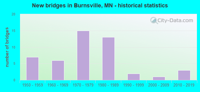
- New bridges - historical statistics
- 71950-1959
- 61960-1969
- 151970-1979
- 131980-1989
- 21990-1999
- 12000-2009
- 32010-2019
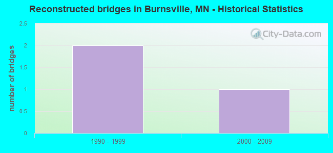
- Reconstructed bridges - Historical Statistics
- 21990-1999
- 12000-2009
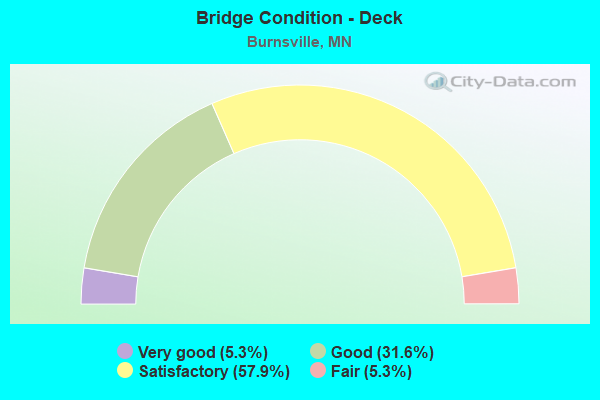
- Bridge Condition - Deck
- 5.3%Very good
- 31.6%Good
- 57.9%Satisfactory
- 5.3%Fair
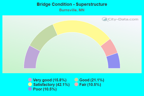
- Bridge Condition - Superstructure
- 15.8%Very good
- 21.1%Good
- 42.1%Satisfactory
- 10.5%Fair
- 10.5%Poor
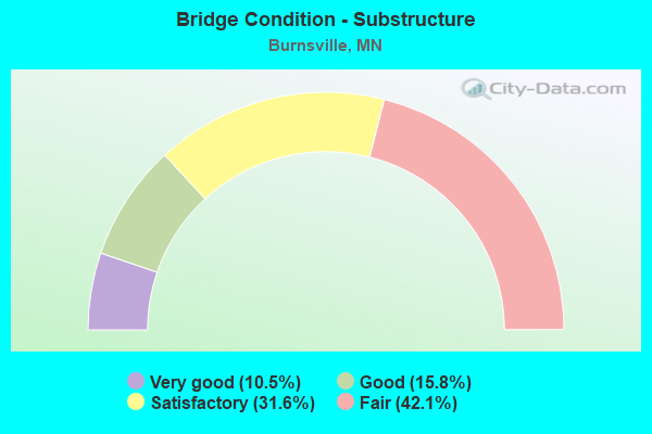
- Bridge Condition - Substructure
- 10.5%Very good
- 15.8%Good
- 31.6%Satisfactory
- 42.1%Fair
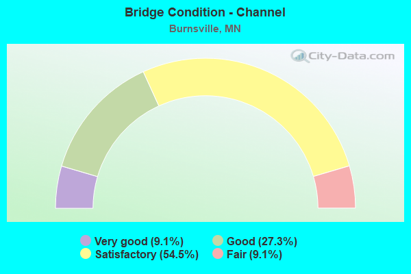
- Bridge Condition - Channel
- 9.1%Very good
- 27.3%Good
- 54.5%Satisfactory
- 9.1%Fair
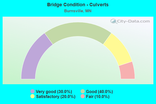
- Bridge Condition - Culverts
- 30.0%Very good
- 40.0%Good
- 20.0%Satisfactory
- 10.0%Fair
Find on map >> Show street view
Structure Number: 19036, Location: AT JCT OF TH 13; CSAH 5 (Lat: 44.772647, Lng: -93.304883), Route carried "on" structure: County highway 5, Year Built: 2013, Status: Open, Structure Length: 5.04m (16.54ft), Average Daily Traffic: 24,800 (year 2017), Average Future Daily Traffic: 24,800 (year 2039), Design Load: HL 93, Features Intersected: TH 13
Minimum Vertical Clearance: 30+ m (98+ ft), Kilometerpoint: 0.000, Lanes on structure: 6, Lanes under structure: 5, Owner: State Highway Agency, Approaching Roadway Width: 16.5m (54.1ft), Skew: 20 degrees, Material/Design: Prestressed concrete, Design/Construction: Stringer/Multi-beam, Number Of Spans In Main Unit: 2, Length of Maximum Span: 25.8m (84.6ft), Curb or Sidewalk Widths: Left: 0.0m, Right: 3.7m (12.1ft), Curb-To-Curb Width: 30.5m (100.1ft), Out-to-Out Width: 35.0m (114.8ft)
Condition: Deck: Good, Superstructure: Very good, Substructure: Good, Operating Rating: 60.3 metric tons, Method Used To Determine Operating Rating: Load and Resistance Factor Rating (LRFR) rating reported by rating factor(RF) method using HL-93 loadings, Inventory Rating: 37.9 metric tons, Method Used To Determine Inventory Rating: Load and Resistance Factor Rating (LRFR) rating reported by rating factor(RF) method using HL-93 loadings, Structural Evaluation: Better than present minimum criteria, Deck Geometry: Superior to present desirable criteria, Underclear: Equal to present desirable criteria, Approach Roadway Alignment: Equal to present desirable criteria, Designated Inspection Frequency: Every 24 months, Inspection Date: April 2021, Deck Structure Type: Concrete Cast-file-Place, Wearing Surface/Protective System: Wearing Surface: Monolithic Concrete, Deck Protection: Epoxy Coated Reinforcing
Find on map >> Show street view
Structure Number: 19522, Location: 1.8 MI S OF JCT TH 13 (Lat: 44.752408, Lng: -93.286156), Route carried "on" structure: County highway 38, Year Built: 1984, Status: Open, Structure Length: 6.24m (20.47ft), Average Daily Traffic: 17,100 (year 2016), Average Future Daily Traffic: 17,100 (year 2039), Design Load: HS 20, Features Intersected: I 35W
Minimum Vertical Clearance: 30+ m (98+ ft), Kilometerpoint: 0.000, Lanes on structure: 4, Lanes under structure: 4, Owner: State Highway Agency, Approaching Roadway Width: 22.6m (74.1ft), Skew: 20 degrees, Material/Design: Prestressed concrete, Design/Construction: Stringer/Multi-beam, Number Of Spans In Main Unit: 2, Length of Maximum Span: 30.5m (100.1ft), Curb or Sidewalk Widths: Left: 2.4m (7.9ft), Right: 2.4m (7.9ft), Curb-To-Curb Width: 18.3m (60.0ft), Out-to-Out Width: 28.7m (94.2ft)
Condition: Deck: Satisfactory, Superstructure: Fair, Substructure: Fair, Operating Rating: 57.8 metric tons, Method Used To Determine Operating Rating: Load Factor (LF), Inventory Rating: 36.6 metric tons, Method Used To Determine Inventory Rating: Load Factor (LF), Structural Evaluation: Somewhat better than minimum adequacy, Deck Geometry: Somewhat better than minimum adequacy, Underclear: Somewhat better than minimum adequacy, Approach Roadway Alignment: Equal to present desirable criteria, Designated Inspection Frequency: Every 24 months, Inspection Date: April 2021, Deck Structure Type: Concrete Cast-file-Place, Wearing Surface/Protective System: Wearing Surface: Low Slump Concrete, Deck Protection: Epoxy Coated Reinforcing
Find on map >> Show street view
Structure Number: 19527, Location: 0.4 MI N OF JCT TH 35E (Lat: 44.745742, Lng: -93.282981), Route carried "on" structure: County highway 42, Year Built: 1989, Status: Open, Structure Length: 8.86m (29.07ft), Average Daily Traffic: 51,292 (year 2019), Truck Traffic: 3%, Average Future Daily Traffic: 51,000 (year 2039), Design Load: HS 25 or greater, Features Intersected: I 35W
Minimum Vertical Clearance: 30+ m (98+ ft), Kilometerpoint: 0.000, Lanes on structure: 10, Lanes under structure: 4, Base Highway Network: Yes, Owner: State Highway Agency, Approaching Roadway Width: 43.3m (142.1ft), Skew: 23 degrees, Material/Design: Steel continuous, Design/Construction: Stringer/Multi-beam, Number Of Spans In Main Unit: 2, Length of Maximum Span: 43.9m (144.0ft), Curb or Sidewalk Widths: Left: 2.4m (7.9ft), Right: 2.4m (7.9ft), Curb-To-Curb Width: 39.0m (128.0ft), Out-to-Out Width: 45.8m (150.3ft)
Condition: Deck: Satisfactory, Superstructure: Satisfactory, Substructure: Fair, Operating Rating: 97.8 metric tons, Method Used To Determine Operating Rating: Load Factor (LF), Inventory Rating: 58.6 metric tons, Method Used To Determine Inventory Rating: Load Factor (LF), Structural Evaluation: Somewhat better than minimum adequacy, Deck Geometry: Somewhat better than minimum adequacy, Underclear: Better than present minimum criteria, Approach Roadway Alignment: Equal to present desirable criteria, Designated Inspection Frequency: Every 24 months, Inspection Date: April 2021, Deck Structure Type: Concrete Cast-file-Place, Wearing Surface/Protective System: Wearing Surface: Low Slump Concrete, Deck Protection: Epoxy Coated Reinforcing
Find on map >> Show street view
Structure Number: 1956, Location: 0.3 MI W OF JCT CSAH 5 (Lat: 44.746453, Lng: -93.309975), Route carried "on" structure: County highway 42, Year Built: 2007, Status: Open, Structure Length: 5.06m (16.60ft), Average Daily Traffic: 37,020 (year 2019), Truck Traffic: 3%, Average Future Daily Traffic: 39,000 (year 2039), Design Load: HL 93, Features Intersected: CP RR
Minimum Vertical Clearance: 30+ m (98+ ft), Kilometerpoint: 0.000, Lanes on structure: 6, Base Highway Network: Yes, Owner: County Highway Agency, Approaching Roadway Width: 28.0m (91.9ft), Skew: 23 degrees, Material/Design: Prestressed concrete, Design/Construction: Stringer/Multi-beam, Number Of Spans In Main Unit: 3, Length of Maximum Span: 17.9m (58.7ft), Curb or Sidewalk Widths: Left: 3.7m (12.1ft), Right: 3.7m (12.1ft), Curb-To-Curb Width: 37.2m (122.0ft), Out-to-Out Width: 46.1m (151.2ft)
Condition: Deck: Good, Superstructure: Very good, Substructure: Very good, Operating Rating: 47.3 metric tons, Method Used To Determine Operating Rating: Load Factor (LF), Inventory Rating: 28.4 metric tons, Method Used To Determine Inventory Rating: Load Factor (LF), Structural Evaluation: Better than present minimum criteria, Deck Geometry: Superior to present desirable criteria, Underclear: Equal to present minimum criteria, Approach Roadway Alignment: Equal to present desirable criteria, Designated Inspection Frequency: Every 24 months, Inspection Date: January 2021, Deck Structure Type: Concrete Cast-file-Place, Wearing Surface/Protective System: Wearing Surface: Low Slump Concrete, Deck Protection: Epoxy Coated Reinforcing
Find on map >> Show street view
Structure Number: 19564, Location: 0.2 MI NE OF JCT TH 35 W (Lat: 44.800850, Lng: -93.284325), Route carried "on" structure: City street 1, Year Built: 2012, Status: Open, Structure Length: 2.30m (7.55ft), Average Daily Traffic: 1,040 (year 1987), Average Future Daily Traffic: 1,040 (year 2029), Design Load: HL 93, Features Intersected: CHANNEL
Minimum Vertical Clearance: 30+ m (98+ ft), Kilometerpoint: 0.000, Lanes on structure: 2, Owner: City or Municipal Highway Agency, Approaching Roadway Width: 8.5m (27.9ft), Material/Design: Prestressed concrete, Design/Construction: Stringer/Multi-beam, Number Of Spans In Main Unit: 1, Length of Maximum Span: 22.6m (74.1ft), Curb or Sidewalk Widths: Left: 3.7m (12.1ft), Right: 0.0m, Curb-To-Curb Width: 8.5m (27.9ft), Out-to-Out Width: 13.5m (44.3ft)
Condition: Deck: Very good, Superstructure: Very good, Substructure: Very good, Channel: Good, Operating Rating: 48.3 metric tons, Method Used To Determine Operating Rating: Load and Resistance Factor Rating (LRFR) rating reported by rating factor(RF) method using HL-93 loadings, Inventory Rating: 36.6 metric tons, Method Used To Determine Inventory Rating: Load and Resistance Factor Rating (LRFR) rating reported by rating factor(RF) method using HL-93 loadings, Structural Evaluation: Equal to present desirable criteria, Deck Geometry: Somewhat better than minimum adequacy, Waterway Adequacy: High priority of corrective action, Approach Roadway Alignment: Equal to present desirable criteria, Designated Inspection Frequency: Every 24 months, Inspection Date: August 2021, Deck Structure Type: Concrete Cast-file-Place, Wearing Surface/Protective System: Wearing Surface: Monolithic Concrete, Deck Protection: Epoxy Coated Reinforcing
Find on map >> Show street view
Structure Number: 19804, Location: 0.5 MI S OF JCT TH 35 E (Lat: 44.730575, Lng: -93.283042), Route carried "on" structure: City street 101, Year Built: 1988, Status: Open, Structure Length: 6.78m (22.24ft), Average Daily Traffic: 7,400 (year 2014), Average Future Daily Traffic: 7,400 (year 2039), Design Load: HS 25 or greater, Features Intersected: I 35
Minimum Vertical Clearance: 30+ m (98+ ft), Kilometerpoint: 0.000, Lanes on structure: 4, Lanes under structure: 6, Owner: State Highway Agency, Approaching Roadway Width: 16.5m (54.1ft), Skew: 3 degrees, Material/Design: Prestressed concrete, Design/Construction: Stringer/Multi-beam, Number Of Spans In Main Unit: 2, Length of Maximum Span: 32.9m (107.9ft), Curb or Sidewalk Widths: Left: 1.8m (5.9ft), Right: 0.0m, Curb-To-Curb Width: 16.5m (54.1ft), Out-to-Out Width: 19.1m (62.7ft)
Condition: Deck: Good, Superstructure: Good, Substructure: Fair, Operating Rating: 71.5 metric tons, Method Used To Determine Operating Rating: Load Factor (LF), Inventory Rating: 40.8 metric tons, Method Used To Determine Inventory Rating: Load Factor (LF), Structural Evaluation: Somewhat better than minimum adequacy, Deck Geometry: Meets minimum limits, Underclear: Somewhat better than minimum adequacy, Approach Roadway Alignment: Equal to present desirable criteria, Designated Inspection Frequency: Every 24 months, Inspection Date: April 2021, Deck Structure Type: Concrete Cast-file-Place, Wearing Surface/Protective System: Wearing Surface: Low Slump Concrete, Deck Protection: Epoxy Coated Reinforcing
Find on map >> Show street view
Structure Number: 19809, Location: AT S JCT TH 35;35E (Lat: 44.739894, Lng: -93.283058), Route carried "on" structure: Interstate 35E, Year Built: 1964, Year Reconstructed: 2013, Status: Open, Structure Length: 10.91m (35.79ft), Average Daily Traffic: 22,500 (year 2017), Truck Traffic: 3%, Average Future Daily Traffic: 22,500 (year 2039), Design Load: HS 20, Features Intersected: I 35W
Minimum Vertical Clearance: 30+ m (98+ ft), Kilometerpoint: 0.000, Lanes on structure: 2, Lanes under structure: 4, Base Highway Network: Yes, Owner: State Highway Agency, Approaching Roadway Width: 11.6m (38.1ft), Skew: 5 degrees, Material/Design: Steel continuous, Design/Construction: Stringer/Multi-beam, Number Of Spans In Main Unit: 4, Length of Maximum Span: 31.9m (104.7ft), Curb-To-Curb Width: 12.1m (39.7ft), Out-to-Out Width: 13.1m (43.0ft)
Condition: Deck: Good, Superstructure: Good, Substructure: Satisfactory, Operating Rating: 59.4 metric tons, Method Used To Determine Operating Rating: Load Factor (LF), Inventory Rating: 35.6 metric tons, Method Used To Determine Inventory Rating: Load Factor (LF), Structural Evaluation: Equal to present minimum criteria, Deck Geometry: Equal to present minimum criteria, Underclear: Somewhat better than minimum adequacy, Approach Roadway Alignment: Equal to present desirable criteria, Designated Inspection Frequency: Every 24 months, Inspection Date: July 2020, Deck Structure Type: Concrete Cast-file-Place, Wearing Surface/Protective System: Wearing Surface: Epoxy Overlay, Deck Protection: Epoxy Coated Reinforcing
Find on map >> Show street view
Structure Number: 19811, Location: 0.4 MI NE OF JCT TH 35W (Lat: 44.743489, Lng: -93.277472), Route carried "on" structure: Interstate 35E, Year Built: 1978, Status: Open, Structure Length: 8.50m (27.89ft), Average Daily Traffic: 28,000 (year 2017), Truck Traffic: 3%, Average Future Daily Traffic: 28,000 (year 2039), Design Load: HS 20, Features Intersected: CSAH 42
Minimum Vertical Clearance: 30+ m (98+ ft), Kilometerpoint: 0.000, Lanes on structure: 2, Lanes under structure: 4, Base Highway Network: Yes, Owner: State Highway Agency, Approaching Roadway Width: 11.6m (38.1ft), Skew: 1 degrees, Material/Design: Steel continuous, Design/Construction: Stringer/Multi-beam, Number Of Spans In Main Unit: 3, Length of Maximum Span: 46.7m (153.2ft), Curb-To-Curb Width: 12.4m (40.7ft), Out-to-Out Width: 13.5m (44.3ft)
Condition: Deck: Satisfactory, Superstructure: Good, Substructure: Good, Operating Rating: 71.8 metric tons, Method Used To Determine Operating Rating: Load Factor (LF), Inventory Rating: 43.1 metric tons, Method Used To Determine Inventory Rating: Load Factor (LF), Structural Evaluation: Better than present minimum criteria, Deck Geometry: Better than present minimum criteria, Underclear: Better than present minimum criteria, Approach Roadway Alignment: Equal to present desirable criteria, Designated Inspection Frequency: Every 24 months, Inspection Date: July 2020, Deck Structure Type: Concrete Cast-file-Place, Wearing Surface/Protective System: Wearing Surface: Low Slump Concrete, Deck Protection: Epoxy Coated Reinforcing
Find on map >> Show street view
Structure Number: 19813, Location: 2.3 MI NE OF JCT TH 35W (Lat: 44.759547, Lng: -93.247986), Route carried "on" structure: Interstate 35E, Year Built: 1979, Status: Open, Structure Length: 7.75m (25.43ft), Average Daily Traffic: 32,500 (year 2017), Truck Traffic: 4%, Average Future Daily Traffic: 32,500 (year 2039), Design Load: HS 20, Features Intersected: CSAH 11
Minimum Vertical Clearance: 30+ m (98+ ft), Kilometerpoint: 0.000, Lanes on structure: 2, Lanes under structure: 5, Base Highway Network: Yes, Owner: State Highway Agency, Approaching Roadway Width: 11.6m (38.1ft), Skew: 3 degrees, Material/Design: Prestressed concrete, Design/Construction: Stringer/Multi-beam, Number Of Spans In Main Unit: 3, Length of Maximum Span: 36.7m (120.4ft), Curb-To-Curb Width: 12.7m (41.7ft), Out-to-Out Width: 13.7m (44.9ft)
Condition: Deck: Good, Superstructure: Satisfactory, Substructure: Satisfactory, Operating Rating: 65.5 metric tons, Method Used To Determine Operating Rating: Load Factor (LF), Inventory Rating: 39.2 metric tons, Method Used To Determine Inventory Rating: Load Factor (LF), Structural Evaluation: Equal to present minimum criteria, Deck Geometry: Better than present minimum criteria, Underclear: Somewhat better than minimum adequacy, Approach Roadway Alignment: Equal to present desirable criteria, Designated Inspection Frequency: Every 24 months, Inspection Date: July 2020, Deck Structure Type: Concrete Cast-file-Place, Wearing Surface/Protective System: Wearing Surface: Low Slump Concrete, Deck Protection: Epoxy Coated Reinforcing
Find on map >> Show street view
Structure Number: 19814, Location: 2.3 MI NE OF JCT TH 35W (Lat: 44.759225, Lng: -93.248008), Route carried "on" structure: Interstate 35E, Year Built: 1979, Status: Open, Structure Length: 7.00m (22.97ft), Average Daily Traffic: 30,500 (year 2019), Truck Traffic: 4%, Average Future Daily Traffic: 32,500 (year 2039), Design Load: HS 20, Features Intersected: CSAH 11
Minimum Vertical Clearance: 30+ m (98+ ft), Kilometerpoint: 0.000, Lanes on structure: 2, Lanes under structure: 5, Base Highway Network: Yes, Owner: State Highway Agency, Approaching Roadway Width: 11.6m (38.1ft), Skew: 3 degrees, Material/Design: Prestressed concrete, Design/Construction: Stringer/Multi-beam, Number Of Spans In Main Unit: 3, Length of Maximum Span: 36.6m (120.1ft), Curb-To-Curb Width: 12.7m (41.7ft), Out-to-Out Width: 13.7m (44.9ft)
Condition: Deck: Good, Superstructure: Satisfactory, Substructure: Satisfactory, Operating Rating: 71.4 metric tons, Method Used To Determine Operating Rating: Load Factor (LF), Inventory Rating: 36.6 metric tons, Method Used To Determine Inventory Rating: Load Factor (LF), Structural Evaluation: Equal to present minimum criteria, Deck Geometry: Better than present minimum criteria, Underclear: Somewhat better than minimum adequacy, Approach Roadway Alignment: Equal to present desirable criteria, Designated Inspection Frequency: Every 24 months, Inspection Date: July 2020, Deck Structure Type: Concrete Cast-file-Place, Wearing Surface/Protective System: Wearing Surface: Low Slump Concrete, Deck Protection: Epoxy Coated Reinforcing
Find on map >> Show street view
Structure Number: 19863, Location: 2.2 MI N OF JCT TH 35E (Lat: 44.769919, Lng: -93.288597), Route carried "on" structure: City street 102, Year Built: 1969, Status: Open, Structure Length: 6.40m (21.00ft), Average Daily Traffic: 16,800 (year 2015), Average Future Daily Traffic: 16,800 (year 2039), Design Load: HS 20, Features Intersected: I 35W
Minimum Vertical Clearance: 30+ m (98+ ft), Kilometerpoint: 0.000, Lanes on structure: 5, Lanes under structure: 6, Owner: State Highway Agency, Approaching Roadway Width: 20.1m (65.9ft), Material/Design: Steel continuous, Design/Construction: Stringer/Multi-beam, Number Of Spans In Main Unit: 2, Length of Maximum Span: 31.3m (102.7ft), Curb or Sidewalk Widths: Left: 1.5m (4.9ft), Right: 1.5m (4.9ft), Curb-To-Curb Width: 18.9m (62.0ft), Out-to-Out Width: 22.8m (74.8ft)
Condition: Deck: Fair, Superstructure: Poor, Substructure: Fair, Operating Rating: 67.3 metric tons, Method Used To Determine Operating Rating: Load Factor (LF), Inventory Rating: 40.2 metric tons, Method Used To Determine Inventory Rating: Load Factor (LF), Structural Evaluation: Meets minimum limits, Deck Geometry: Meets minimum limits, Underclear: Somewhat better than minimum adequacy, Approach Roadway Alignment: Equal to present desirable criteria, Designated Inspection Frequency: Every 12 months, Inspection Date: July 2021, Deck Structure Type: Concrete Cast-file-Place, Wearing Surface/Protective System: Wearing Surface: Low Slump Concrete, Deck Protection: Epoxy Coated Reinforcing
Find on map >> Show street view
Structure Number: 19889, Location: 1.0 MI NE OF JCT TH 35W (Lat: 44.749206, Lng: -93.268264), Route carried "on" structure: City street 101, Year Built: 1979, Status: Open, Structure Length: 9.17m (30.09ft), Average Daily Traffic: 6,800 (year 2014), Average Future Daily Traffic: 6,800 (year 2039), Design Load: HS 20, Features Intersected: I 35E
Minimum Vertical Clearance: 30+ m (98+ ft), Kilometerpoint: 0.000, Lanes on structure: 4, Lanes under structure: 4, Owner: State Highway Agency, Approaching Roadway Width: 17.7m (58.1ft), Skew: 4 degrees, Material/Design: Steel continuous, Design/Construction: Stringer/Multi-beam, Number Of Spans In Main Unit: 2, Length of Maximum Span: 44.8m (147.0ft), Curb or Sidewalk Widths: Left: 1.8m (5.9ft), Right: 1.8m (5.9ft), Curb-To-Curb Width: 17.1m (56.1ft), Out-to-Out Width: 21.4m (70.2ft)
Condition: Deck: Satisfactory, Superstructure: Satisfactory, Substructure: Fair, Operating Rating: 72.8 metric tons, Method Used To Determine Operating Rating: Load Factor (LF), Inventory Rating: 43.7 metric tons, Method Used To Determine Inventory Rating: Load Factor (LF), Structural Evaluation: Somewhat better than minimum adequacy, Deck Geometry: Somewhat better than minimum adequacy, Underclear: Better than present minimum criteria, Approach Roadway Alignment: Equal to present desirable criteria, Designated Inspection Frequency: Every 24 months, Inspection Date: July 2020, Deck Structure Type: Concrete Cast-file-Place, Wearing Surface/Protective System: Wearing Surface: Epoxy Overlay, Deck Protection: Epoxy Coated Reinforcing
Find on map >> Show street view
Structure Number: 19891, Location: AT S JCT TH 35E; 35 (Lat: 44.737269, Lng: -93.283439), Route carried "on" structure: Interstate 35W, Year Built: 1980, Status: Open, Structure Length: 7.36m (24.15ft), Average Daily Traffic: 26,500 (year 2017), Truck Traffic: 9%, Average Future Daily Traffic: 26,500 (year 2039), Design Load: HS 20, Features Intersected: SOTHCROSS DRIVE
Minimum Vertical Clearance: 30+ m (98+ ft), Kilometerpoint: 0.000, Lanes on structure: 2, Lanes under structure: 6, Base Highway Network: Yes, Owner: State Highway Agency, Approaching Roadway Width: 12.5m (41.0ft), Skew: 1 degrees, Material/Design: Steel, Design/Construction: Stringer/Multi-beam, Number Of Spans In Main Unit: 1, Number Of Approach Spans: 2, Length of Maximum Span: 50.6m (166.0ft), Curb-To-Curb Width: 12.4m (40.7ft), Out-to-Out Width: 13.5m (44.3ft)
Condition: Deck: Satisfactory, Superstructure: Satisfactory, Substructure: Good, Operating Rating: 84.9 metric tons, Method Used To Determine Operating Rating: Load Factor (LF), Inventory Rating: 50.6 metric tons, Method Used To Determine Inventory Rating: Load Factor (LF), Structural Evaluation: Equal to present minimum criteria, Deck Geometry: Better than present minimum criteria, Underclear: Superior to present desirable criteria, Approach Roadway Alignment: Equal to present desirable criteria, Designated Inspection Frequency: Every 24 months, Inspection Date: April 2021, Deck Structure Type: Concrete Cast-file-Place, Wearing Surface/Protective System: Wearing Surface: Low Slump Concrete, Deck Protection: Epoxy Coated Reinforcing
Find on map >> Show street view
Structure Number: 19892, Location: AT JCT TH 35E; 35 (Lat: 44.737206, Lng: -93.283158), Route carried "on" structure: Interstate 35W, Year Built: 1980, Status: Open, Structure Length: 7.05m (23.13ft), Average Daily Traffic: 25,000 (year 2019), Truck Traffic: 7%, Average Future Daily Traffic: 26,500 (year 2039), Design Load: HS 20, Features Intersected: SOTHCROSS DRIVE
Minimum Vertical Clearance: 30+ m (98+ ft), Kilometerpoint: 0.000, Lanes on structure: 4, Lanes under structure: 6, Base Highway Network: Yes, Owner: State Highway Agency, Approaching Roadway Width: 16.2m (53.1ft), Skew: 1 degrees, Material/Design: Steel, Design/Construction: Stringer/Multi-beam, Number Of Spans In Main Unit: 1, Number Of Approach Spans: 2, Length of Maximum Span: 50.6m (166.0ft), Curb-To-Curb Width: 21.7m (71.2ft), Out-to-Out Width: 22.7m (74.5ft)
Condition: Deck: Satisfactory, Superstructure: Satisfactory, Substructure: Satisfactory, Operating Rating: 99.6 metric tons, Method Used To Determine Operating Rating: Load Factor (LF), Inventory Rating: 72.2 metric tons, Method Used To Determine Inventory Rating: Load Factor (LF), Structural Evaluation: Equal to present minimum criteria, Deck Geometry: Better than present minimum criteria, Underclear: Better than present minimum criteria, Approach Roadway Alignment: Equal to present desirable criteria, Designated Inspection Frequency: Every 24 months, Inspection Date: April 2021, Deck Structure Type: Concrete Cast-file-Place, Wearing Surface/Protective System: Wearing Surface: Low Slump Concrete, Deck Protection: Epoxy Coated Reinforcing
Find on map >> Show street view
Structure Number: 19893, Location: AT THE JCT TH 35W (Lat: 44.737519, Lng: -93.284569), Route carried "on" structure: Interstate 35E, Year Built: 1979, Status: Open, Structure Length: 9.73m (31.92ft), Average Daily Traffic: 22,500 (year 2017), Truck Traffic: 3%, Average Future Daily Traffic: 22,500 (year 2039), Design Load: HS 20, Features Intersected: Southcross Drive
Minimum Vertical Clearance: 30+ m (98+ ft), Kilometerpoint: 0.000, Lanes on structure: 2, Lanes under structure: 6, Base Highway Network: Yes, Owner: State Highway Agency, Approaching Roadway Width: 11.6m (38.1ft), Material/Design: Steel, Design/Construction: Stringer/Multi-beam, Number Of Spans In Main Unit: 1, Number Of Approach Spans: 4, Length of Maximum Span: 52.3m (171.6ft), Curb-To-Curb Width: 12.4m (40.7ft), Out-to-Out Width: 13.5m (44.3ft)
Condition: Deck: Satisfactory, Superstructure: Satisfactory, Substructure: Satisfactory, Operating Rating: 78.2 metric tons, Method Used To Determine Operating Rating: Load Factor (LF), Inventory Rating: 46.9 metric tons, Method Used To Determine Inventory Rating: Load Factor (LF), Structural Evaluation: Equal to present minimum criteria, Deck Geometry: Better than present minimum criteria, Underclear: Superior to present desirable criteria, Approach Roadway Alignment: Equal to present desirable criteria, Designated Inspection Frequency: Every 24 months, Inspection Date: July 2020, Deck Structure Type: Concrete Cast-file-Place, Wearing Surface/Protective System: Wearing Surface: Epoxy Overlay, Deck Protection: Epoxy Coated Reinforcing
Find on map >> Show street view
Structure Number: 6583, Location: 0.5 MI N OF JCT TH 13 (Lat: 44.782167, Lng: -93.288475), Route carried "on" structure: Interstate 35W, Year Built: 1959, Status: Open, Structure Length: 4.72m (15.49ft), Average Daily Traffic: 92,000 (year 2019), Truck Traffic: 5%, Average Future Daily Traffic: 96,000 (year 2039), Design Load: HS 20, Features Intersected: UP RR, Cliff Rd (CSAH32)
Minimum Vertical Clearance: 30+ m (98+ ft), Kilometerpoint: 0.000, Lanes on structure: 8, Lanes under structure: 2, Base Highway Network: Yes, Owner: State Highway Agency, Approaching Roadway Width: 37.2m (122.0ft), Skew: 31 degrees, Material/Design: Steel continuous, Design/Construction: Stringer/Multi-beam, Number Of Spans In Main Unit: 2, Length of Maximum Span: 22.9m (75.1ft), Curb-To-Curb Width: 38.2m (125.3ft), Out-to-Out Width: 40.0m (131.2ft)
Condition: Deck: Satisfactory, Superstructure: Poor, Substructure: Fair, Operating Rating: 55.5 metric tons, Method Used To Determine Operating Rating: Load Factor (LF), Inventory Rating: 33.3 metric tons, Method Used To Determine Inventory Rating: Load Factor (LF), Structural Evaluation: Meets minimum limits, Deck Geometry: Superior to present desirable criteria, Underclear: High priority of corrective action, Approach Roadway Alignment: Equal to present desirable criteria, Length Of Structure Improvement: 1.59m (5.22ft), Designated Inspection Frequency: Every 12 months, Inspection Date: July 2021, Bridge Improvement Cost: $999,999,000, Deck Structure Type: Concrete Cast-file-Place, Wearing Surface/Protective System: Wearing Surface: Monolithic Concrete, Deck Protection: Epoxy Coated Reinforcing
Find on map >> Show street view
Structure Number: 917, Location: 0.5 MI E OF JCT CSAH 13 (Lat: 46.643589, Lng: -95.509300), Route carried "on" structure: County highway 8, Year Built: 1978, Status: Open, Structure Length: 0.90m (2.95ft), Average Daily Traffic: 1,250 (year 2015), Average Future Daily Traffic: 1,250 (year 2039), Design Load: HS 20, Features Intersected: TOAD RIVER
Minimum Vertical Clearance: 30+ m (98+ ft), Kilometerpoint: 0.000, Lanes on structure: 2, Owner: County Highway Agency, Approaching Roadway Width: 12.8m (42.0ft), Skew: 1 degrees, Material/Design: Concrete, Design/Construction: Culvert, Number Of Spans In Main Unit: 2, Length of Maximum Span: 3.7m (12.1ft)
Condition: Channel: Satisfactory, Culverts: Satisfactory, Operating Rating: 58.8 metric tons, Method Used To Determine Operating Rating: Assigned rating based on Load Factor Design (LFD) reported in metric tons, Inventory Rating: 39.2 metric tons, Method Used To Determine Inventory Rating: Assigned rating based on Load Factor Design (LFD) reported in metric tons, Structural Evaluation: Equal to present minimum criteria, Waterway Adequacy: Equal to present desirable criteria, Approach Roadway Alignment: Equal to present desirable criteria, Length Of Structure Improvement: 0.43m (1.41ft), Designated Inspection Frequency: Every 48 months, Inspection Date: November 2021, Bridge Improvement Cost: $85,000,000, Total Project Cost: $192,000,000
Find on map >> Show street view
Structure Number: 91751, Location: 1.1 MI N OF JCT CSAH 60 (Lat: 46.680533, Lng: -95.542808), Route carried "on" structure: County highway 230, Year Built: 1978, Status: Open, Structure Length: 1.00m (3.28ft), Average Daily Traffic: 31 (year 1986), Average Future Daily Traffic: 31 (year 2029), Design Load: HS 20, Features Intersected: TOAD RIVER
Minimum Vertical Clearance: 30+ m (98+ ft), Kilometerpoint: 0.000, Lanes on structure: 2, Owner: Town or Township Highway Agency, Approaching Roadway Width: 7.6m (24.9ft), Material/Design: Concrete, Design/Construction: Culvert, Number Of Spans In Main Unit: 2, Length of Maximum Span: 4.3m (14.1ft)
Condition: Channel: Good, Culverts: Good, Operating Rating: 53.9 metric tons, Method Used To Determine Operating Rating: Assigned ratings based on Allowable Stress Design (ASD) reported in metric tons, Inventory Rating: 35.9 metric tons, Method Used To Determine Inventory Rating: Assigned ratings based on Allowable Stress Design (ASD) reported in metric tons, Structural Evaluation: Better than present minimum criteria, Waterway Adequacy: Equal to present desirable criteria, Approach Roadway Alignment: Equal to present desirable criteria, Length Of Structure Improvement: 0.49m (1.61ft), Designated Inspection Frequency: Every 48 months, Inspection Date: November 2021, Bridge Improvement Cost: $110,000,000, Total Project Cost: $145,000,000
Find on map >> Show street view
Structure Number: 91798, Location: 0.8 MI W OF JCT CSAH 13 (Lat: 46.716133, Lng: -95.539842), Route carried "on" structure: County highway 1173, Year Built: 1980, Status: Posted for load, Structure Length: 0.90m (2.95ft), Average Daily Traffic: 21 (year 1986), Average Future Daily Traffic: 21 (year 2029), Features Intersected: TOAD RIVER
Minimum Vertical Clearance: 30+ m (98+ ft), Kilometerpoint: 0.000, Lanes on structure: 2, Owner: Town or Township Highway Agency, Approaching Roadway Width: 8.5m (27.9ft), Material/Design: Steel, Design/Construction: Culvert, Number Of Spans In Main Unit: 2, Length of Maximum Span: 4.0m (13.1ft)
Condition: Channel: Good, Culverts: Fair, Operating Rating: 14.7 metric tons, Method Used To Determine Operating Rating: Field evaluation and documented engineering judgment, Inventory Rating: 11.4 metric tons, Method Used To Determine Inventory Rating: Field evaluation and documented engineering judgment, Structural Evaluation: Meets minimum limits, Waterway Adequacy: Somewhat better than minimum adequacy, Approach Roadway Alignment: Equal to present desirable criteria, Bridge Posting: Required (Relationship of Operating Rating to Maximum Legal Load: > 39.9% below), Length Of Structure Improvement: 0.43m (1.41ft), Designated Inspection Frequency: Every 12 months, Inspection Date: November 2021, Bridge Improvement Cost: $91,217,000, Roadway Improvement Cost: $36,487,000, Total Project Cost: $127,704,000
Find on map >> Show street view
Structure Number: 91899, Location: 0.2 MI W OF JCT CSAH 13 (Lat: 46.665306, Lng: -95.524536), Route carried "on" structure: County highway 60, Year Built: 1985, Status: Open, Structure Length: 0.95m (3.12ft), Average Daily Traffic: 380 (year 2015), Average Future Daily Traffic: 380 (year 2039), Design Load: HS 20, Features Intersected: TOAD RIVER
Minimum Vertical Clearance: 30+ m (98+ ft), Kilometerpoint: 0.000, Lanes on structure: 2, Owner: County Highway Agency, Approaching Roadway Width: 11.0m (36.1ft), Material/Design: Concrete, Design/Construction: Culvert, Number Of Spans In Main Unit: 2, Length of Maximum Span: 4.3m (14.1ft)
Condition: Channel: Satisfactory, Culverts: Very good, Operating Rating: 53.9 metric tons, Method Used To Determine Operating Rating: Assigned ratings based on Allowable Stress Design (ASD) reported in metric tons, Inventory Rating: 35.9 metric tons, Method Used To Determine Inventory Rating: Assigned ratings based on Allowable Stress Design (ASD) reported in metric tons, Structural Evaluation: Equal to present desirable criteria, Waterway Adequacy: Equal to present desirable criteria, Approach Roadway Alignment: Equal to present desirable criteria, Length Of Structure Improvement: 0.46m (1.51ft), Designated Inspection Frequency: Every 48 months, Inspection Date: November 2021, Bridge Improvement Cost: $90,000,000, Total Project Cost: $156,000,000
Find on map >> Show street view
Structure Number: 91933, Location: 0.5 MI N OF JCT CSAH 8 (Lat: 46.651256, Lng: -95.519608), Route carried "on" structure: County highway 13, Year Built: 1999, Status: Open, Structure Length: 0.91m (2.99ft), Average Daily Traffic: 860 (year 2015), Average Future Daily Traffic: 860 (year 2039), Design Load: HS 25 or greater, Features Intersected: TOAD RIVER
Minimum Vertical Clearance: 30+ m (98+ ft), Kilometerpoint: 0.000, Lanes on structure: 2, Owner: County Highway Agency, Approaching Roadway Width: 8.5m (27.9ft), Material/Design: Concrete, Design/Construction: Culvert, Number Of Spans In Main Unit: 2, Length of Maximum Span: 3.7m (12.1ft)
Condition: Channel: Satisfactory, Culverts: Good, Operating Rating: 68.6 metric tons, Method Used To Determine Operating Rating: Assigned rating based on Load Factor Design (LFD) reported in metric tons, Inventory Rating: 40.8 metric tons, Method Used To Determine Inventory Rating: Assigned rating based on Load Factor Design (LFD) reported in metric tons, Structural Evaluation: Better than present minimum criteria, Waterway Adequacy: Equal to present desirable criteria, Approach Roadway Alignment: Equal to present desirable criteria, Designated Inspection Frequency: Every 48 months, Inspection Date: November 2020
Find on map >> Show street view
Structure Number: 95049, Location: 0.2 MI W OF JCT CSAH 67 (Lat: 46.716186, Lng: -95.391944), Route carried "on" structure: County highway 1172, Year Built: 1980, Status: Open, Structure Length: 0.93m (3.05ft), Average Daily Traffic: 36 (year 1986), Average Future Daily Traffic: 36 (year 2029), Design Load: HS 20, Features Intersected: RED EYE RIVER
Minimum Vertical Clearance: 30+ m (98+ ft), Kilometerpoint: 0.000, Lanes on structure: 2, Owner: Town or Township Highway Agency, Approaching Roadway Width: 10.7m (35.1ft), Material/Design: Concrete, Design/Construction: Culvert, Number Of Spans In Main Unit: 2, Length of Maximum Span: 3.9m (12.8ft)
Condition: Channel: Fair, Culverts: Good, Operating Rating: 53.9 metric tons, Method Used To Determine Operating Rating: Assigned ratings based on Allowable Stress Design (ASD) reported in metric tons, Inventory Rating: 35.9 metric tons, Method Used To Determine Inventory Rating: Assigned ratings based on Allowable Stress Design (ASD) reported in metric tons, Structural Evaluation: Better than present minimum criteria, Waterway Adequacy: Equal to present desirable criteria, Approach Roadway Alignment: Equal to present desirable criteria, Length Of Structure Improvement: 0.46m (1.51ft), Designated Inspection Frequency: Every 24 months, Inspection Date: November 2020, Bridge Improvement Cost: $68,000,000, Total Project Cost: $161,000,000
Find on map >> Show street view
Structure Number: 95168, Location: 1.4 MI S OF N CO LINE (Lat: 46.696033, Lng: -95.330964), Route carried "on" structure: County highway 108, Year Built: 1979, Status: Open, Structure Length: 0.93m (3.05ft), Average Daily Traffic: 30 (year 1986), Average Future Daily Traffic: 30 (year 2029), Design Load: HS 20, Features Intersected: RED EYE RIVER
Minimum Vertical Clearance: 30+ m (98+ ft), Kilometerpoint: 0.000, Lanes on structure: 2, Owner: Town or Township Highway Agency, Approaching Roadway Width: 7.6m (24.9ft), Material/Design: Concrete, Design/Construction: Culvert, Number Of Spans In Main Unit: 2, Length of Maximum Span: 3.9m (12.8ft)
Condition: Channel: Satisfactory, Culverts: Good, Operating Rating: 53.9 metric tons, Method Used To Determine Operating Rating: Assigned ratings based on Allowable Stress Design (ASD) reported in metric tons, Inventory Rating: 35.9 metric tons, Method Used To Determine Inventory Rating: Assigned ratings based on Allowable Stress Design (ASD) reported in metric tons, Structural Evaluation: Better than present minimum criteria, Waterway Adequacy: Equal to present desirable criteria, Approach Roadway Alignment: Equal to present desirable criteria, Length Of Structure Improvement: 0.46m (1.51ft), Designated Inspection Frequency: Every 48 months, Inspection Date: November 2020, Bridge Improvement Cost: $68,000,000, Total Project Cost: $124,000,000
Find on map >> Show street view
Structure Number: 96883, Location: 1.8 MI N OF JCT CSAH 62 (Lat: 46.699336, Lng: -95.353425), Route carried "on" structure: County highway 67, Year Built: 1990, Status: Open, Structure Length: 0.93m (3.05ft), Average Daily Traffic: 340 (year 2015), Average Future Daily Traffic: 340 (year 2039), Design Load: HS 20, Features Intersected: RED EYE RIVER
Minimum Vertical Clearance: 30+ m (98+ ft), Kilometerpoint: 0.000, Lanes on structure: 2, Owner: County Highway Agency, Approaching Roadway Width: 10.4m (34.1ft), Material/Design: Concrete, Design/Construction: Culvert, Number Of Spans In Main Unit: 2, Length of Maximum Span: 3.9m (12.8ft)
Condition: Channel: Satisfactory, Culverts: Very good, Operating Rating: 53.9 metric tons, Method Used To Determine Operating Rating: Assigned ratings based on Allowable Stress Design (ASD) reported in metric tons, Inventory Rating: 35.9 metric tons, Method Used To Determine Inventory Rating: Assigned ratings based on Allowable Stress Design (ASD) reported in metric tons, Structural Evaluation: Equal to present desirable criteria, Waterway Adequacy: Better than present minimum criteria, Approach Roadway Alignment: Equal to present desirable criteria, Length Of Structure Improvement: 0.46m (1.51ft), Designated Inspection Frequency: Every 48 months, Inspection Date: November 2020, Bridge Improvement Cost: $88,000,000, Total Project Cost: $124,000,000
Find on map >> Show street view
Structure Number: 9693, Location: 3.2 MI N OF JCT TH 210 (Lat: 46.334531, Lng: -96.124083), Route carried "on" structure: Interstate 94, Year Built: 1960, Status: Open, Structure Length: 0.65m (2.13ft), Average Daily Traffic: 9,100 (year 2019), Truck Traffic: 16%, Average Future Daily Traffic: 9,100 (year 2039), Features Intersected: PELICAN RIVER
Minimum Vertical Clearance: 30+ m (98+ ft), Kilometerpoint: 0.000, Lanes on structure: 2, Base Highway Network: Yes, Owner: State Highway Agency, Approaching Roadway Width: 11.6m (38.1ft), Skew: 3 degrees, Material/Design: Concrete, Design/Construction: Culvert, Number Of Spans In Main Unit: 2, Length of Maximum Span: 3.0m (9.8ft)
Condition: Channel: Very good, Culverts: Satisfactory, Operating Rating: 39.2 metric tons, Method Used To Determine Operating Rating: Assigned ratings based on Allowable Stress Design (ASD) reported in metric tons, Inventory Rating: 29.4 metric tons, Method Used To Determine Inventory Rating: Assigned ratings based on Allowable Stress Design (ASD) reported in metric tons, Structural Evaluation: Equal to present minimum criteria, Waterway Adequacy: Equal to present desirable criteria, Approach Roadway Alignment: Equal to present desirable criteria, Designated Inspection Frequency: Every 24 months, Inspection Date: August 2021
Find on map >> Show street view
Structure Number: 9693, Location: 0.4 MI S OF JCT TH 13 (Lat: 44.777667, Lng: -93.260222), Route carried "on" structure: City street 104, Year Built: 1969, Status: Open, Structure Length: 3.63m (11.91ft), Average Daily Traffic: 5,100 (year 2014), Average Future Daily Traffic: 5,100 (year 2039), Design Load: H 20, Features Intersected: PED WALK
Minimum Vertical Clearance: 30+ m (98+ ft), Kilometerpoint: 0.000, Lanes on structure: 2, Owner: Local Agency, Approaching Roadway Width: 13.7m (44.9ft), Material/Design: Steel, Design/Construction: Culvert, Number Of Spans In Main Unit: 1, Length of Maximum Span: 3.3m (10.8ft)
Condition: Culverts: Very good, Operating Rating: 39.2 metric tons, Method Used To Determine Operating Rating: Assigned ratings based on Allowable Stress Design (ASD) reported in metric tons, Inventory Rating: 26.1 metric tons, Method Used To Determine Inventory Rating: Assigned ratings based on Allowable Stress Design (ASD) reported in metric tons, Structural Evaluation: Equal to present minimum criteria, Approach Roadway Alignment: Equal to present desirable criteria, Designated Inspection Frequency: Every 24 months, Inspection Date: June 2020
Find on map >> Show street view
Structure Number: 9779, Location: AT THE JCT OF TH 13; 35W (Lat: 44.775322, Lng: -93.288369), Route carried "on" structure: State highway 13, Year Built: 1959, Year Reconstructed: 1996, Status: Open, Structure Length: 5.92m (19.42ft), Average Daily Traffic: 17,750 (year 2015), Truck Traffic: 8%, Average Future Daily Traffic: 17,750 (year 2039), Design Load: HS 20, Features Intersected: I 35W
Minimum Vertical Clearance: 30+ m (98+ ft), Kilometerpoint: 0.000, Lanes on structure: 3, Lanes under structure: 4, Base Highway Network: Yes, Owner: State Highway Agency, Approaching Roadway Width: 12.2m (40.0ft), Skew: 1 degrees, Material/Design: Steel continuous, Design/Construction: Stringer/Multi-beam, Number Of Spans In Main Unit: 2, Length of Maximum Span: 28.7m (94.2ft), Curb-To-Curb Width: 12.8m (42.0ft), Out-to-Out Width: 13.8m (45.3ft)
Condition: Deck: Satisfactory, Superstructure: Satisfactory, Substructure: Fair, Operating Rating: 57.1 metric tons, Method Used To Determine Operating Rating: Load Factor (LF), Inventory Rating: 34.3 metric tons, Method Used To Determine Inventory Rating: Load Factor (LF), Structural Evaluation: Somewhat better than minimum adequacy, Deck Geometry: Meets minimum limits, Underclear: High priority of corrective action, Approach Roadway Alignment: Better than present minimum criteria, Length Of Structure Improvement: 1.98m (6.50ft), Designated Inspection Frequency: Every 24 months, Inspection Date: July 2020, Bridge Improvement Cost: $999,999,000, Roadway Improvement Cost: $59,000,000, Total Project Cost: $889,000,000, Deck Structure Type: Concrete Cast-file-Place, Wearing Surface/Protective System: Wearing Surface: Low Slump Concrete, Deck Protection: Epoxy Coated Reinforcing
Find on map >> Show street view
Structure Number: 978, Location: AT THE JCT OF TH 13; 35W (Lat: 44.775108, Lng: -93.288375), Route carried "on" structure: State highway 13, Year Built: 1959, Year Reconstructed: 1996, Status: Open, Structure Length: 5.92m (19.42ft), Average Daily Traffic: 20,000 (year 2019), Truck Traffic: 4%, Average Future Daily Traffic: 17,750 (year 2039), Design Load: HS 20, Features Intersected: I 35W
Minimum Vertical Clearance: 30+ m (98+ ft), Kilometerpoint: 0.000, Lanes on structure: 3, Lanes under structure: 4, Base Highway Network: Yes, Owner: State Highway Agency, Approaching Roadway Width: 12.2m (40.0ft), Skew: 1 degrees, Material/Design: Steel continuous, Design/Construction: Stringer/Multi-beam, Number Of Spans In Main Unit: 2, Length of Maximum Span: 28.7m (94.2ft), Curb-To-Curb Width: 12.8m (42.0ft), Out-to-Out Width: 13.8m (45.3ft)
Condition: Deck: Satisfactory, Superstructure: Fair, Substructure: Fair, Operating Rating: 57.3 metric tons, Method Used To Determine Operating Rating: Load Factor (LF), Inventory Rating: 34.3 metric tons, Method Used To Determine Inventory Rating: Load Factor (LF), Structural Evaluation: Somewhat better than minimum adequacy, Deck Geometry: Meets minimum limits, Underclear: High priority of corrective action, Approach Roadway Alignment: Better than present minimum criteria, Length Of Structure Improvement: 1.98m (6.50ft), Designated Inspection Frequency: Every 24 months, Inspection Date: July 2020, Bridge Improvement Cost: $999,999,000, Roadway Improvement Cost: $59,000,000, Total Project Cost: $889,000,000, Deck Structure Type: Concrete Cast-file-Place, Wearing Surface/Protective System: Wearing Surface: Low Slump Concrete, Deck Protection: Epoxy Coated Reinforcing
Find on map >> Show street view
Structure Number: L5773, Location: 0.1 MI W OF TH 77 (Lat: 44.825006, Lng: -93.233483), Route carried "on" structure: City street 980, Year Built: 1953, Status: Posted for load, Structure Length: 0.79m (2.59ft), Average Daily Traffic: 872 (year 1987), Average Future Daily Traffic: 872 (year 2029), Features Intersected: BLACKDOG CREEK
Minimum Vertical Clearance: 30+ m (98+ ft), Kilometerpoint: 0.000, Lanes on structure: 2, Owner: City or Municipal Highway Agency, Approaching Roadway Width: 6.7m (22.0ft), Material/Design: Concrete, Design/Construction: Frame, Number Of Spans In Main Unit: 1, Length of Maximum Span: 6.7m (22.0ft), Curb-To-Curb Width: 6.7m (22.0ft), Out-to-Out Width: 7.3m (24.0ft)
Condition: Deck: Satisfactory, Superstructure: Good, Substructure: Satisfactory, Channel: Satisfactory, Operating Rating: 23.2 metric tons, Method Used To Determine Operating Rating: Field evaluation and documented engineering judgment, Inventory Rating: 13.9 metric tons, Method Used To Determine Inventory Rating: Field evaluation and documented engineering judgment, Structural Evaluation: Meets minimum limits, Deck Geometry: Meets minimum limits, Waterway Adequacy: Somewhat better than minimum adequacy, Approach Roadway Alignment: Somewhat better than minimum adequacy, Bridge Posting: Required (Relationship of Operating Rating to Maximum Legal Load: > 39.9% below), Length Of Structure Improvement: 0.40m (1.31ft), Designated Inspection Frequency: Every 12 months, Underwater Inspection Frequency: Every 60 months, Inspection Date: August 2021, Underwater Inspection Date: June 2021, Bridge Improvement Cost: $75,000,000, Roadway Improvement Cost: $15,000,000, Total Project Cost: $62,000,000, Deck Structure Type: Concrete Cast-file-Place, Wearing Surface/Protective System: Wearing Surface: Low Slump Concrete
Find on map >> Show street view
Structure Number: 19036, Location: AT JCT OF TH 13; CSAH 5 (Lat: 44.772647, Lng: -93.304883), Route carried "under" structure: State highway 13, Year Built: 2013, Structure Length: 0. m, Average Daily Traffic: 56,852 (year 2019), Truck Traffic: 8%, Features Intersected: TH 13, Facility Carried by Structure: CSAH 5
Minimum Vertical Clearance: 5.18m (16.99ft), Kilometerpoint: 0.000, Lanes under structure: 5, Material/Design: Prestressed concrete, Design/Construction: Stringer/Multi-beam, Length of Maximum Span: 25.8m (84.6ft)
Find on map >> Show street view
Structure Number: 19522, Location: 1.8 MI S OF JCT TH 13 (Lat: 44.752408, Lng: -93.286156), Route carried "under" structure: Interstate 35W, Year Built: 1984, Structure Length: 0. m, Average Daily Traffic: 78,000 (year 2019), Truck Traffic: 6%, Features Intersected: I 35W, Facility Carried by Structure: CSAH 38
Minimum Vertical Clearance: 5.09m (16.70ft), Kilometerpoint: 0.000, Lanes on structure: 4, Lanes under structure: 4, Material/Design: Prestressed concrete, Design/Construction: Stringer/Multi-beam, Length of Maximum Span: 30.5m (100.1ft)
Find on map >> Show street view
Structure Number: 19527, Location: 0.4 MI N OF JCT TH 35E (Lat: 44.745742, Lng: -93.282981), Route carried "under" structure: Interstate 35W, Year Built: 1989, Structure Length: 0. m, Average Daily Traffic: 50,000 (year 2019), Truck Traffic: 7%, Features Intersected: I 35W, Facility Carried by Structure: CSAH 42
Minimum Vertical Clearance: 5.30m (17.39ft), Kilometerpoint: 0.000, Lanes on structure: 10, Lanes under structure: 4, Material/Design: Steel continuous, Design/Construction: Stringer/Multi-beam, Length of Maximum Span: 43.9m (144.0ft)
Find on map >> Show street view
Structure Number: 19804, Location: 0.5 MI S OF JCT TH 35 E (Lat: 44.730575, Lng: -93.283042), Route carried "under" structure: Interstate 35, Year Built: 1988, Structure Length: 0. m, Average Daily Traffic: 104,000 (year 2019), Truck Traffic: 8%, Features Intersected: I 35, Facility Carried by Structure: MSAS 101
Minimum Vertical Clearance: 5.91m (19.39ft), Kilometerpoint: 0.000, Lanes on structure: 4, Lanes under structure: 6, Material/Design: Prestressed concrete, Design/Construction: Stringer/Multi-beam, Length of Maximum Span: 32.9m (107.9ft)
Find on map >> Show street view
Structure Number: 19809, Location: AT S JCT TH 35;35E (Lat: 44.739894, Lng: -93.283058), Route carried "under" structure: Interstate 35W, Year Built: 1964, Structure Length: 0. m, Average Daily Traffic: 50,000 (year 2019), Truck Traffic: 7%, Features Intersected: I 35W, Facility Carried by Structure: I 35E
Minimum Vertical Clearance: 4.88m (16.01ft), Kilometerpoint: 0.000, Lanes on structure: 2, Lanes under structure: 4, Material/Design: Steel continuous, Design/Construction: Stringer/Multi-beam, Length of Maximum Span: 31.9m (104.7ft)
Find on map >> Show street view
Structure Number: 19811, Location: 0.4 MI NE OF JCT TH 35W (Lat: 44.743489, Lng: -93.277472), Route carried "under" structure: County highway 42, Year Built: 1978, Structure Length: 0. m, Average Daily Traffic: 51,292 (year 2019), Truck Traffic: 3%, Features Intersected: CSAH 42, Facility Carried by Structure: I 35E
Minimum Vertical Clearance: 5.43m (17.81ft), Kilometerpoint: 0.000, Lanes on structure: 2, Lanes under structure: 4, Material/Design: Steel continuous, Design/Construction: Stringer/Multi-beam, Length of Maximum Span: 46.7m (153.2ft)
Find on map >> Show street view
Structure Number: 19812, Location: 0.4 MI NE OF JCT TH 35W (Lat: 44.743344, Lng: -93.277200), Route carried "under" structure: County highway 42, Year Built: 1978, Structure Length: 0. m, Average Daily Traffic: 51,292 (year 2019), Truck Traffic: 3%, Features Intersected: CSAH 42, Facility Carried by Structure: I 35E
Minimum Vertical Clearance: 5.36m (17.59ft), Kilometerpoint: 0.000, Lanes on structure: 2, Lanes under structure: 4, Material/Design: Steel continuous, Design/Construction: Stringer/Multi-beam, Length of Maximum Span: 46.7m (153.2ft)
Find on map >> Show street view
Structure Number: 19813, Location: 2.3 MI NE OF JCT TH 35W (Lat: 44.759547, Lng: -93.247986), Route carried "under" structure: County highway 11, Year Built: 1979, Structure Length: 0. m, Average Daily Traffic: 19,000 (year 2007), Features Intersected: CSAH 11, Facility Carried by Structure: I 35E
Minimum Vertical Clearance: 6.92m (22.70ft), Kilometerpoint: 0.000, Lanes on structure: 2, Lanes under structure: 5, Material/Design: Prestressed concrete, Design/Construction: Stringer/Multi-beam, Length of Maximum Span: 36.7m (120.4ft)
Find on map >> Show street view
Structure Number: 19814, Location: 2.3 MI NE OF JCT TH 35W (Lat: 44.759225, Lng: -93.248008), Route carried "under" structure: County highway 11, Year Built: 1979, Structure Length: 0. m, Average Daily Traffic: 19,000 (year 2007), Features Intersected: CSAH 11, Facility Carried by Structure: I 35E
Minimum Vertical Clearance: 5.49m (18.01ft), Kilometerpoint: 0.000, Lanes on structure: 2, Lanes under structure: 5, Material/Design: Prestressed concrete, Design/Construction: Stringer/Multi-beam, Length of Maximum Span: 36.6m (120.1ft)
Find on map >> Show street view
Structure Number: 19863, Location: 2.2 MI N OF JCT TH 35E (Lat: 44.769919, Lng: -93.288597), Route carried "under" structure: Interstate 35W, Year Built: 1969, Structure Length: 0. m, Average Daily Traffic: 89,000 (year 2019), Truck Traffic: 6%, Features Intersected: I 35W, Facility Carried by Structure: MSAS 102
Minimum Vertical Clearance: 4.94m (16.21ft), Kilometerpoint: 0.000, Lanes on structure: 5, Lanes under structure: 6, Material/Design: Steel continuous, Design/Construction: Stringer/Multi-beam, Length of Maximum Span: 31.3m (102.7ft)
Find on map >> Show street view
Structure Number: 19866, Location: 1.6 MI NE OF JCT TH 35W (Lat: 44.753747, Lng: -93.261100), Route carried "under" structure: Interstate 35E, Year Built: 1979, Structure Length: 0. m, Average Daily Traffic: 59,000 (year 2019), Truck Traffic: 4%, Features Intersected: I 35E, Facility Carried by Structure: CSAH 38
Minimum Vertical Clearance: 6.25m (20.51ft), Kilometerpoint: 0.000, Lanes on structure: 4, Lanes under structure: 4, Material/Design: Steel continuous, Design/Construction: Stringer/Multi-beam, Length of Maximum Span: 46.6m (152.9ft)
Find on map >> Show street view
Structure Number: 19889, Location: 1.0 MI NE OF JCT TH 35W (Lat: 44.749206, Lng: -93.268264), Route carried "under" structure: Interstate 35E, Year Built: 1979, Structure Length: 0. m, Average Daily Traffic: 59,000 (year 2019), Truck Traffic: 4%, Features Intersected: I 35E, Facility Carried by Structure: MSAS 101
Minimum Vertical Clearance: 6.04m (19.82ft), Kilometerpoint: 0.000, Lanes on structure: 4, Lanes under structure: 4, Material/Design: Steel continuous, Design/Construction: Stringer/Multi-beam, Length of Maximum Span: 44.8m (147.0ft)
Find on map >> Show street view
Structure Number: 19891, Location: AT S JCT TH 35E; 35 (Lat: 44.737269, Lng: -93.283439), Route carried "under" structure: City street 113, Year Built: 1980, Structure Length: 0. m, Average Daily Traffic: 6,800 (year 2007), Features Intersected: SOTHCROSS DRIVE, Facility Carried by Structure: I 35W
Minimum Vertical Clearance: 5.55m (18.21ft), Kilometerpoint: 0.000, Lanes on structure: 2, Lanes under structure: 6, Material/Design: Steel, Design/Construction: Stringer/Multi-beam, Length of Maximum Span: 50.6m (166.0ft)
Find on map >> Show street view
Structure Number: 19892, Location: AT JCT TH 35E; 35 (Lat: 44.737206, Lng: -93.283158), Route carried "under" structure: City street 113, Year Built: 1980, Structure Length: 0. m, Average Daily Traffic: 6,800 (year 2007), Features Intersected: SOTHCROSS DRIVE, Facility Carried by Structure: I 35W
Minimum Vertical Clearance: 5.09m (16.70ft), Kilometerpoint: 0.000, Lanes on structure: 4, Lanes under structure: 6, Material/Design: Steel, Design/Construction: Stringer/Multi-beam, Length of Maximum Span: 50.6m (166.0ft)
Find on map >> Show street view
Structure Number: 19893, Location: AT THE JCT TH 35W (Lat: 44.737519, Lng: -93.284569), Route carried "under" structure: City street 113, Year Built: 1979, Structure Length: 0. m, Average Daily Traffic: 6,600 (year 2005), Features Intersected: Southcross Drive, Facility Carried by Structure: I 35E
Minimum Vertical Clearance: 8.20m (26.90ft), Kilometerpoint: 0.000, Lanes on structure: 2, Lanes under structure: 6, Material/Design: Steel, Design/Construction: Stringer/Multi-beam, Length of Maximum Span: 52.3m (171.6ft)
Find on map >> Show street view
Structure Number: 6583, Location: 0.5 MI N OF JCT TH 13 (Lat: 44.782167, Lng: -93.288475), Route carried "under" structure: County highway 32, Year Built: 1959, Structure Length: 0. m, Average Daily Traffic: 11,300 (year 2007), Features Intersected: UP RR, Cliff Rd (CSAH32), Facility Carried by Structure: I 35W
Minimum Vertical Clearance: 6.07m (19.91ft), Kilometerpoint: 0.000, Lanes on structure: 8, Lanes under structure: 2, Material/Design: Steel continuous, Design/Construction: Stringer/Multi-beam, Length of Maximum Span: 22.9m (75.1ft)
Find on map >> Show street view
Structure Number: 9779, Location: AT THE JCT OF TH 13; 35W (Lat: 44.775322, Lng: -93.288369), Route carried "under" structure: Interstate 35W, Year Built: 1959, Structure Length: 0. m, Average Daily Traffic: 89,000 (year 2019), Truck Traffic: 6%, Features Intersected: I 35W, Facility Carried by Structure: MN 13
Minimum Vertical Clearance: 4.66m (15.29ft), Kilometerpoint: 0.000, Lanes on structure: 3, Lanes under structure: 4, Material/Design: Steel continuous, Design/Construction: Stringer/Multi-beam, Length of Maximum Span: 28.7m (94.2ft)
Find on map >> Show street view
Structure Number: 978, Location: AT THE JCT OF TH 13; 35W (Lat: 44.775108, Lng: -93.288375), Route carried "under" structure: Interstate 35W, Year Built: 1959, Structure Length: 0. m, Average Daily Traffic: 89,000 (year 2019), Truck Traffic: 6%, Features Intersected: I 35W, Facility Carried by Structure: MN 13
Minimum Vertical Clearance: 4.66m (15.29ft), Kilometerpoint: 0.000, Lanes on structure: 3, Lanes under structure: 4, Material/Design: Steel continuous, Design/Construction: Stringer/Multi-beam, Length of Maximum Span: 28.7m (94.2ft)