Bridge Statistics for Cabin John, Maryland (MD)
Condition, Traffic, Stress, Structural Evaluation, Project Costs
- National Bridge Inventory (NBI) Statistics
- 15Number of bridges
- 335ft / 102mTotal length
- $15,018,000Total costs
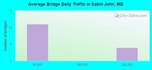
- 984,873Total average daily traffic
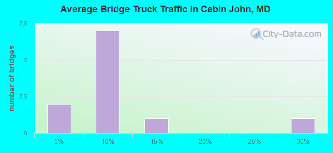
- 93,216Total average daily truck traffic
- National Bridge Inventory (NBI) Registered Bridges for Cabin John
- No street view available for this location
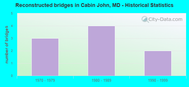
- Reconstructed bridges - Historical Statistics
- 31970-1979
- 41980-1989
- 21990-1999
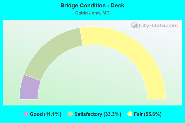
- Bridge Condition - Deck
- 11.1%Good
- 33.3%Satisfactory
- 55.6%Fair
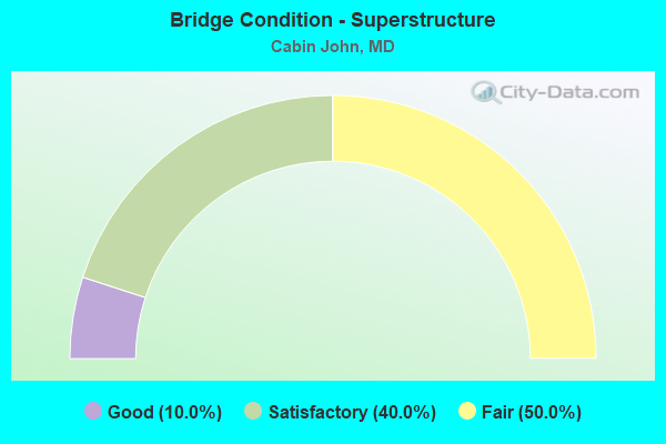
- Bridge Condition - Superstructure
- 10.0%Good
- 40.0%Satisfactory
- 50.0%Fair
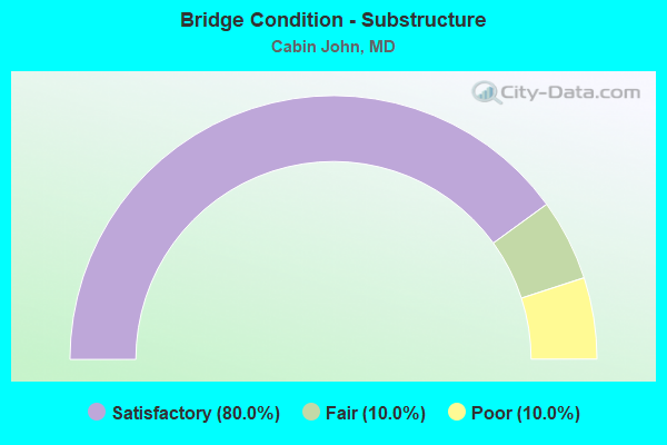
- Bridge Condition - Substructure
- 80.0%Satisfactory
- 10.0%Fair
- 10.0%Poor
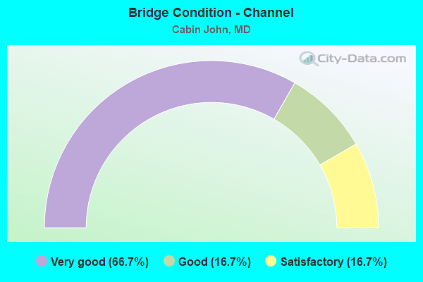
- Bridge Condition - Channel
- 66.7%Very good
- 16.7%Good
- 16.7%Satisfactory
Find on map >> Show street view
Structure Number: 10000015008601, Location: 0.02 MILE SOUTH OF GV 6 (Lat: 38.970494, Lng: -77.146886), Route carried "on" structure: Ramp Interstate 495X, Year Built: 1964, Year Reconstructed: 1970, Status: Open, Structure Length: 7.71m (25.30ft), Average Daily Traffic: 22,160 (year 2012), Truck Traffic: 8%, Average Future Daily Traffic: 27,700 (year 2032), Design Load: H 20, Features Intersected: CABIN JOHN CREEK
Minimum Vertical Clearance: 30+ m (98+ ft), Kilometerpoint: 2.294, Lanes on structure: 1, Base Highway Network: Yes, Owner: State Highway Agency, Approaching Roadway Width: 8.2m (26.9ft), Material/Design: Concrete continuous, Design/Construction: Box Beam or Girders - Multiple, Number Of Spans In Main Unit: 3, Length of Maximum Span: 31.7m (104.0ft), Curb or Sidewalk Widths: Left: 0.0m, Right: 1.4m (4.6ft), Curb-To-Curb Width: 8.2m (26.9ft), Out-to-Out Width: 11.0m (36.1ft)
Condition: Deck: Fair, Superstructure: Fair, Substructure: Satisfactory, Channel: Good, Operating Rating: 88.4 metric tons, Method Used To Determine Operating Rating: Load Factor (LF), Inventory Rating: 53.1 metric tons, Method Used To Determine Inventory Rating: Load Factor (LF), Structural Evaluation: Somewhat better than minimum adequacy, Deck Geometry: Superior to present desirable criteria, Waterway Adequacy: Superior to present desirable criteria, Approach Roadway Alignment: Equal to present desirable criteria, Length Of Structure Improvement: 7.71m (25.30ft), Designated Inspection Frequency: Every 24 months, Inspection Date: May 2020, Bridge Improvement Cost: $546,000, Roadway Improvement Cost: $55,000, Total Project Cost: $601,000, Deck Structure Type: Concrete Cast-file-Place, Wearing Surface/Protective System: Wearing Surface: Bituminous
Find on map >> Show street view
Structure Number: 10000015008701, Location: 0.11 MILE NORTH OF GV 6 (Lat: 38.971300, Lng: -77.147428), Route carried "on" structure: Interstate 495X, Year Built: 1964, Year Reconstructed: 1970, Status: Open, Structure Length: 8.29m (27.20ft), Average Daily Traffic: 19,820 (year 2009), Truck Traffic: 8%, Average Future Daily Traffic: 11,081 (year 2026), Design Load: H 20, Features Intersected: CABIN JOHN CREEK
Minimum Vertical Clearance: 30+ m (98+ ft), Kilometerpoint: 0.177, Lanes on structure: 2, Base Highway Network: Yes, Owner: State Highway Agency, Approaching Roadway Width: 8.2m (26.9ft), Material/Design: Concrete continuous, Design/Construction: Box Beam or Girders - Multiple, Number Of Spans In Main Unit: 3, Length of Maximum Span: 32.6m (107.0ft), Curb or Sidewalk Widths: Left: 0.0m, Right: 1.4m (4.6ft), Curb-To-Curb Width: 8.2m (26.9ft), Out-to-Out Width: 11.0m (36.1ft)
Condition: Deck: Fair, Superstructure: Fair, Substructure: Satisfactory, Channel: Very good, Operating Rating: 79.8 metric tons, Method Used To Determine Operating Rating: Load Factor (LF), Inventory Rating: 47.6 metric tons, Method Used To Determine Inventory Rating: Load Factor (LF), Structural Evaluation: Somewhat better than minimum adequacy, Deck Geometry: High priority of replacement, Waterway Adequacy: Superior to present desirable criteria, Approach Roadway Alignment: Equal to present desirable criteria, Length Of Structure Improvement: 8.29m (27.20ft), Designated Inspection Frequency: Every 24 months, Inspection Date: July 2020, Bridge Improvement Cost: $588,000, Roadway Improvement Cost: $59,000, Total Project Cost: $647,000, Deck Structure Type: Concrete Cast-file-Place, Wearing Surface/Protective System: Wearing Surface: Bituminous
Find on map >> Show street view
Structure Number: 10000015010101, Location: 0.34 MILE EAST OF VA LINE (Lat: 38.972000, Lng: -77.178858), Route carried "on" structure: Interstate 495, Year Built: 1963, Year Reconstructed: 1991, Status: Open, Structure Length: 11.00m (36.09ft), Average Daily Traffic: 214,005 (year 2009), Truck Traffic: 8%, Average Future Daily Traffic: 244,752 (year 2026), Design Load: HS 20+Mod, Features Intersected: CLARA BARTON PKWY EBR
Minimum Vertical Clearance: 30+ m (98+ ft), Kilometerpoint: 0.558, Lanes on structure: 8, Lanes under structure: 2, Base Highway Network: Yes, Owner: State Highway Agency, Approaching Roadway Width: 40.8m (133.9ft), Skew: 21 degrees, Material/Design: Steel, Design/Construction: Stringer/Multi-beam, Number Of Spans In Main Unit: 4, Length of Maximum Span: 29.3m (96.1ft), Curb-To-Curb Width: 46.8m (153.5ft), Out-to-Out Width: 48.0m (157.5ft)
Condition: Deck: Satisfactory, Superstructure: Satisfactory, Substructure: Satisfactory, Channel: Very good, Operating Rating: 64.4 metric tons, Method Used To Determine Operating Rating: Load Factor (LF), Inventory Rating: 38.1 metric tons, Method Used To Determine Inventory Rating: Load Factor (LF), Structural Evaluation: Equal to present minimum criteria, Deck Geometry: Superior to present desirable criteria, Underclear: Meets minimum limits, Waterway Adequacy: Superior to present desirable criteria, Approach Roadway Alignment: Equal to present desirable criteria, Length Of Structure Improvement: 11.00m (36.09ft), Designated Inspection Frequency: Every 24 months, Inspection Date: September 2021, Bridge Improvement Cost: $3,411,000, Roadway Improvement Cost: $341,000, Total Project Cost: $3,752,000, Deck Structure Type: Concrete Cast-file-Place, Wearing Surface/Protective System: Wearing Surface: Bituminous, Deck Protection: Epoxy Coated Reinforcing
Find on map >> Show street view
Structure Number: 10000015010202, Location: W OF INTERCHANGE (Lat: 38.971258, Lng: -77.156900), Route carried "on" structure: Federal lands road 6, Year Built: 1963, Status: Open, Structure Length: 15.54m (50.98ft), Average Daily Traffic: 13,090 (year 2009), Truck Traffic: 8%, Average Future Daily Traffic: 19,635 (year 2029), Design Load: HS 20, Features Intersected: ROCK RUN, Facility Carried by Structure: CLARA BARTON PKWY
Minimum Vertical Clearance: 30+ m (98+ ft), Kilometerpoint: 4.650, Lanes on structure: 6, Base Highway Network: Yes, Owner: State Highway Agency, Approaching Roadway Width: 12.2m (40.0ft), Skew: 2 degrees, Material/Design: Concrete, Design/Construction: Culvert, Length of Maximum Span: 3.0m (9.8ft)
Condition: Channel: Satisfactory, Culverts: Satisfactory, Operating Rating: 32.7 metric tons, Method Used To Determine Operating Rating: Field evaluation and documented engineering judgment, Inventory Rating: 32.7 metric tons, Method Used To Determine Inventory Rating: Field evaluation and documented engineering judgment, Structural Evaluation: Equal to present minimum criteria, Waterway Adequacy: Equal to present desirable criteria, Approach Roadway Alignment: Equal to present desirable criteria, Designated Inspection Frequency: Every 24 months, Inspection Date: August 2021
Find on map >> Show street view
Structure Number: 10000015010401, Location: 0.52 MILE EAST OF VA LINE (Lat: 38.974353, Lng: -77.178367), Route carried "on" structure: Interstate 495, Year Built: 1963, Year Reconstructed: 1991, Status: Open, Structure Length: 18.50m (60.70ft), Average Daily Traffic: 214,005 (year 2009), Truck Traffic: 8%, Average Future Daily Traffic: 244,752 (year 2026), Design Load: HS 20+Mod, Features Intersected: MACARTHUR BLVD, CB PKWY
Minimum Vertical Clearance: 30+ m (98+ ft), Kilometerpoint: 0.837, Lanes on structure: 9, Lanes under structure: 5, Base Highway Network: Yes, Owner: State Highway Agency, Approaching Roadway Width: 44.5m (146.0ft), Skew: 29 degrees, Material/Design: Steel, Design/Construction: Stringer/Multi-beam, Number Of Spans In Main Unit: 5, Number Of Approach Spans: 1, Length of Maximum Span: 33.2m (108.9ft), Curb-To-Curb Width: 44.6m (146.3ft), Out-to-Out Width: 45.8m (150.3ft)
Condition: Deck: Fair, Superstructure: Fair, Substructure: Satisfactory, Operating Rating: 74.8 metric tons, Method Used To Determine Operating Rating: Load Factor (LF), Inventory Rating: 44.9 metric tons, Method Used To Determine Inventory Rating: Load Factor (LF), Structural Evaluation: Somewhat better than minimum adequacy, Deck Geometry: Superior to present desirable criteria, Underclear: High priority of corrective action, Approach Roadway Alignment: Equal to present desirable criteria, Length Of Structure Improvement: 18.50m (60.70ft), Designated Inspection Frequency: Every 24 months, Inspection Date: August 2020, Bridge Improvement Cost: $5,470,000, Roadway Improvement Cost: $547,000, Total Project Cost: $6,017,000, Deck Structure Type: Concrete Cast-file-Place, Wearing Surface/Protective System: Wearing Surface: Bituminous, Deck Protection: Epoxy Coated Reinforcing
Find on map >> Show street view
Structure Number: 10000015010501, Location: 0.06 MI S OF MD 996 (Lat: 38.981275, Lng: -77.172481), Route carried "on" structure: County highway 781, Year Built: 1962, Year Reconstructed: 1970, Status: Open, Structure Length: 6.80m (22.31ft), Average Daily Traffic: 2,910 (year 2009), Truck Traffic: 8%, Average Future Daily Traffic: 4,480 (year 2031), Design Load: H 20, Features Intersected: IS 495, Facility Carried by Structure: PERSIMMON TREE RD
Minimum Vertical Clearance: 30+ m (98+ ft), Kilometerpoint: 0.901, Lanes on structure: 2, Lanes under structure: 6, Owner: State Highway Agency, Approaching Roadway Width: 12.2m (40.0ft), Material/Design: Steel, Design/Construction: Stringer/Multi-beam, Number Of Spans In Main Unit: 4, Length of Maximum Span: 22.9m (75.1ft), Curb or Sidewalk Widths: Left: 1.6m (5.2ft), Right: 0.0m, Curb-To-Curb Width: 9.1m (29.9ft), Out-to-Out Width: 11.9m (39.0ft)
Condition: Deck: Fair, Superstructure: Fair, Substructure: Fair, Operating Rating: 53.5 metric tons, Method Used To Determine Operating Rating: Load Factor (LF), Inventory Rating: 32.2 metric tons, Method Used To Determine Inventory Rating: Load Factor (LF), Structural Evaluation: Somewhat better than minimum adequacy, Deck Geometry: Meets minimum limits, Underclear: Somewhat better than minimum adequacy, Approach Roadway Alignment: Equal to present minimum criteria, Length Of Structure Improvement: 6.80m (22.31ft), Designated Inspection Frequency: Every 24 months, Inspection Date: September 2020, Bridge Improvement Cost: $522,000, Roadway Improvement Cost: $52,000, Total Project Cost: $574,000, Deck Structure Type: Concrete Cast-file-Place, Wearing Surface/Protective System: Wearing Surface: Bituminous
Find on map >> Show street view
Structure Number: 10000015010601, Location: 0.59 MILE EAST OF MD 190 (Lat: 38.983631, Lng: -77.160722), Route carried "on" structure: Interstate 495, Year Built: 1962, Year Reconstructed: 1990, Status: Open, Structure Length: 4.72m (15.49ft), Average Daily Traffic: 214,005 (year 2009), Truck Traffic: 25%, Average Future Daily Traffic: 247,805 (year 2029), Design Load: HS 20+Mod, Features Intersected: SEVEN LOCKS RD
Minimum Vertical Clearance: 30+ m (98+ ft), Kilometerpoint: 2.864, Lanes on structure: 9, Lanes under structure: 2, Base Highway Network: Yes, Owner: State Highway Agency, Approaching Roadway Width: 51.5m (169.0ft), Skew: 34 degrees, Material/Design: Steel, Design/Construction: Stringer/Multi-beam, Number Of Spans In Main Unit: 3, Length of Maximum Span: 22.6m (74.1ft), Curb-To-Curb Width: 46.3m (151.9ft), Out-to-Out Width: 47.5m (155.8ft)
Condition: Deck: Satisfactory, Superstructure: Satisfactory, Substructure: Satisfactory, Operating Rating: 75.7 metric tons, Method Used To Determine Operating Rating: Load Factor (LF), Inventory Rating: 45.4 metric tons, Method Used To Determine Inventory Rating: Load Factor (LF), Structural Evaluation: Equal to present minimum criteria, Deck Geometry: Superior to present desirable criteria, Underclear: Better than present minimum criteria, Approach Roadway Alignment: Equal to present desirable criteria, Designated Inspection Frequency: Every 24 months, Inspection Date: June 2021, Deck Structure Type: Concrete Cast-file-Place, Wearing Surface/Protective System: Wearing Surface: Bituminous, Deck Protection: Epoxy Coated Reinforcing
Find on map >> Show street view
Structure Number: 10000015014201, Location: 0.39 MI E OF VA LINE (Lat: 38.972469, Lng: -77.178622), Route carried "on" structure: Ramp Interstate 495, Year Built: 1963, Year Reconstructed: 1990, Status: Open, Structure Length: 13.38m (43.90ft), Average Daily Traffic: 7,021 (year 2006), Truck Traffic: 8%, Average Future Daily Traffic: 7,583 (year 2026), Design Load: HS 20+Mod, Features Intersected: CLARA BARTON PKY & CANAL
Minimum Vertical Clearance: 30+ m (98+ ft), Kilometerpoint: 0.113, Lanes on structure: 1, Lanes under structure: 4, Base Highway Network: Yes, Owner: State Highway Agency, Approaching Roadway Width: 7.3m (24.0ft), Skew: 9 degrees, Material/Design: Steel, Design/Construction: Stringer/Multi-beam, Number Of Spans In Main Unit: 3, Number Of Approach Spans: 2, Length of Maximum Span: 29.6m (97.1ft), Curb-To-Curb Width: 7.4m (24.3ft), Out-to-Out Width: 8.6m (28.2ft)
Condition: Deck: Satisfactory, Superstructure: Satisfactory, Substructure: Satisfactory, Channel: Very good, Operating Rating: 90.2 metric tons, Method Used To Determine Operating Rating: Load Factor (LF), Inventory Rating: 54.0 metric tons, Method Used To Determine Inventory Rating: Load Factor (LF), Structural Evaluation: Equal to present minimum criteria, Deck Geometry: Better than present minimum criteria, Underclear: High priority of corrective action, Waterway Adequacy: Equal to present desirable criteria, Approach Roadway Alignment: Equal to present minimum criteria, Length Of Structure Improvement: 13.38m (43.90ft), Designated Inspection Frequency: Every 24 months, Inspection Date: May 2021, Bridge Improvement Cost: $743,000, Roadway Improvement Cost: $74,000, Total Project Cost: $817,000, Deck Structure Type: Concrete Cast-file-Place, Wearing Surface/Protective System: Wearing Surface: Bituminous
Find on map >> Show street view
Structure Number: 3300031P, Location: 0.7 MILES SOUTH OF I-495; (Lat: 38.972917, Lng: -77.164444), Route carried "on" structure: Federal lands road 6, Year Built: 1961, Status: Open, Structure Length: 0.86m (2.82ft), Average Daily Traffic: 8,970 (year 2013), Truck Traffic: 1%, Average Future Daily Traffic: 12,600 (year 2033), Design Load: H 20, Features Intersected: RIVERSIDE DRIVE, Facility Carried by Structure: CLARA BARTON PARKW
Minimum Vertical Clearance: 30+ m (98+ ft), Kilometerpoint: 7.049, Lanes on structure: 4, Lanes under structure: 2, Owner: National Park Service, Approaching Roadway Width: 19.5m (64.0ft), Skew: 20 degrees, Material/Design: Concrete, Design/Construction: Frame, Number Of Spans In Main Unit: 1, Length of Maximum Span: 8.6m (28.2ft), Curb-To-Curb Width: 24.4m (80.1ft), Out-to-Out Width: 25.6m (84.0ft)
Condition: Superstructure: Good, Substructure: Satisfactory, Operating Rating: 82.5 metric tons, Method Used To Determine Operating Rating: Load Factor (LF), Inventory Rating: 49.0 metric tons, Method Used To Determine Inventory Rating: Load Factor (LF), Structural Evaluation: Equal to present minimum criteria, Deck Geometry: Superior to present desirable criteria, Underclear: High priority of corrective action, Approach Roadway Alignment: Equal to present desirable criteria, Designated Inspection Frequency: Every 24 months, Inspection Date: April 2021, Bridge Improvement Cost: $40,000, Roadway Improvement Cost: $4,000, Total Project Cost: $60,000 ( Estimate for 2021)
Find on map >> Show street view
Structure Number: 3300032P, Location: 1.3 MILES SOUTH OF I-495. (Lat: 38.971000, Lng: -77.152694), Route carried "on" structure: Alternate Federal lands road 6, Year Built: 1962, Year Reconstructed: 1991, Status: Open, Structure Length: 3.66m (12.01ft), Average Daily Traffic: 1,000 (year 2013), Truck Traffic: 10%, Average Future Daily Traffic: 1,100 (year 2033), Design Load: H 20, Features Intersected: CLARA BARTON PARKWAY, Facility Carried by Structure: ERICSSON ROAD
Minimum Vertical Clearance: 30+ m (98+ ft), Kilometerpoint: 6.019, Lanes on structure: 2, Lanes under structure: 4, Owner: National Park Service, Approaching Roadway Width: 11.0m (36.1ft), Material/Design: Prestressed concrete, Design/Construction: Stringer/Multi-beam, Number Of Spans In Main Unit: 1, Length of Maximum Span: 36.6m (120.1ft), Curb or Sidewalk Widths: Left: 1.2m (3.9ft), Right: 1.2m (3.9ft), Curb-To-Curb Width: 11.0m (36.1ft), Out-to-Out Width: 14.2m (46.6ft)
Condition: Deck: Good, Superstructure: Fair, Substructure: Poor, Operating Rating: 32.7 metric tons, Method Used To Determine Operating Rating: Field evaluation and documented engineering judgment, Inventory Rating: 19.0 metric tons, Method Used To Determine Inventory Rating: Field evaluation and documented engineering judgment, Structural Evaluation: Meets minimum limits, Deck Geometry: Better than present minimum criteria, Underclear: Somewhat better than minimum adequacy, Approach Roadway Alignment: Equal to present desirable criteria, Length Of Structure Improvement: 3.66m (12.01ft), Designated Inspection Frequency: Every 24 months, Inspection Date: April 2021, Bridge Improvement Cost: $750,000, Roadway Improvement Cost: $75,000, Total Project Cost: $1,125,000 ( Estimate for 2021), Deck Structure Type: Concrete Cast-file-Place
Find on map >> Show street view
Structure Number: 3300033P, Location: 1.6 MILES SOUTH OF I-495. (Lat: 38.970889, Lng: -77.147028), Route carried "on" structure: Federal lands road 6, Year Built: 1963, Year Reconstructed: 1985, Status: Open, Structure Length: 11.52m (37.80ft), Average Daily Traffic: 8,970 (year 2013), Truck Traffic: 1%, Average Future Daily Traffic: 12,600 (year 2033), Design Load: H 20, Features Intersected: CABIN JOHN CREEK & CABIN, Facility Carried by Structure: CLARA BARTON PARKW
Minimum Vertical Clearance: 30+ m (98+ ft), Kilometerpoint: 5.536, Lanes on structure: 4, Lanes under structure: 2, Owner: National Park Service, Approaching Roadway Width: 17.1m (56.1ft), Skew: 24 degrees, Material/Design: Concrete continuous, Design/Construction: Box Beam or Girders - Multiple, Number Of Spans In Main Unit: 3, Length of Maximum Span: 45.7m (149.9ft), Curb or Sidewalk Widths: Left: 1.4m (4.6ft), Right: 1.4m (4.6ft), Curb-To-Curb Width: 18.4m (60.4ft), Out-to-Out Width: 21.8m (71.5ft)
Condition: Deck: Fair, Superstructure: Satisfactory, Substructure: Satisfactory, Channel: Very good, Operating Rating: 32.7 metric tons, Method Used To Determine Operating Rating: Load Factor (LF), Inventory Rating: 20.0 metric tons, Method Used To Determine Inventory Rating: Load Factor (LF), Structural Evaluation: Somewhat better than minimum adequacy, Deck Geometry: Somewhat better than minimum adequacy, Underclear: Somewhat better than minimum adequacy, Waterway Adequacy: Equal to present desirable criteria, Approach Roadway Alignment: Equal to present desirable criteria, Length Of Structure Improvement: 11.52m (37.80ft), Designated Inspection Frequency: Every 24 months, Inspection Date: April 2021, Bridge Improvement Cost: $950,000, Roadway Improvement Cost: $95,000, Total Project Cost: $1,425,000 ( Estimate for 2021), Deck Structure Type: Concrete Cast-file-Place, Wearing Surface/Protective System: Wearing Surface: Latex Concrete
Find on map >> Show street view
Structure Number: 10000015010401, Location: 0.55 MI W OF MD 191 (Lat: 38.974322, Lng: -77.178511), Route carried "under" structure: County highway 4690, Year Built: 1963, Structure Length: 0. m, Average Daily Traffic: 12,002 (year 2009), Features Intersected: MAC ARTHUR BLVD & GWMP, Facility Carried by Structure: IS 495
Minimum Vertical Clearance: 3.96m (12.99ft), Kilometerpoint: 7.868, Lanes on structure: 4, Lanes under structure: 5, Material/Design: Steel, Design/Construction: Stringer/Multi-beam, Length of Maximum Span: 33.2m (108.9ft)
Find on map >> Show street view
Structure Number: 10000015010501, Location: 0.06 MI S OF MD 996 (Lat: 38.981275, Lng: -77.172481), Route carried "under" structure: Interstate 495, Year Built: 1962, Structure Length: 0. m, Average Daily Traffic: 214,005 (year 2009), Features Intersected: IS 495, Facility Carried by Structure: PERSIMMON TREE RD
Minimum Vertical Clearance: 4.88m (16.01ft), Kilometerpoint: 1.786, Lanes on structure: 2, Lanes under structure: 6, Material/Design: Steel, Design/Construction: Stringer/Multi-beam, Length of Maximum Span: 23.5m (77.1ft)
Find on map >> Show street view
Structure Number: 10000015010801, Location: 0.24 MILE SOUTH OF IS 495 (Lat: 38.984356, Lng: -77.159200), Route carried "under" structure: Interstate 495X, Year Built: 1962, Structure Length: 0. m, Average Daily Traffic: 19,820 (year 2009), Features Intersected: IS 495X & C J CR, Facility Carried by Structure: IS 495
Minimum Vertical Clearance: 6.10m (20.01ft), Kilometerpoint: 1.963, Lanes on structure: 3, Lanes under structure: 2, Material/Design: Steel, Design/Construction: Stringer/Multi-beam, Length of Maximum Span: 25.3m (83.0ft)
Find on map >> Show street view
Structure Number: 10000015014201, Location: 0.39 MI E OF VA LINE (Lat: 38.972469, Lng: -77.178622), Route carried "under" structure: Federal lands road GV6, Year Built: 1963, Structure Length: 0. m, Average Daily Traffic: 13,090 (year 2009), Features Intersected: CLARA BARTON PKWY, Facility Carried by Structure: IS 495 SE RAMP
Minimum Vertical Clearance: 6.10m (20.01ft), Kilometerpoint: 4.328, Lanes on structure: 1, Lanes under structure: 4, Material/Design: Steel, Design/Construction: Stringer/Multi-beam, Length of Maximum Span: 29.6m (97.1ft)