Bridge Statistics for Cahokia, Illinois (IL)
Condition, Traffic, Stress, Structural Evaluation, Project Costs
- National Bridge Inventory (NBI) Statistics
- 22Number of bridges
- 610ft / 186mTotal length
- $1,125,000Total costs
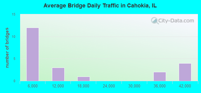
- 277,175Total average daily traffic
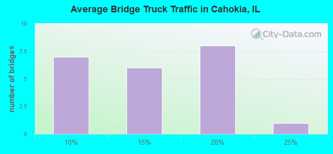
- 44,885Total average daily truck traffic
- National Bridge Inventory (NBI) Registered Bridges for Cahokia
- No street view available for this location
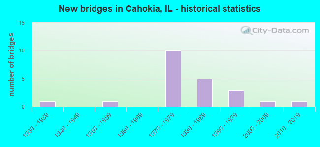
- New bridges - historical statistics
- 11930-1939
- 11950-1959
- 101970-1979
- 51980-1989
- 31990-1999
- 12000-2009
- 12010-2019
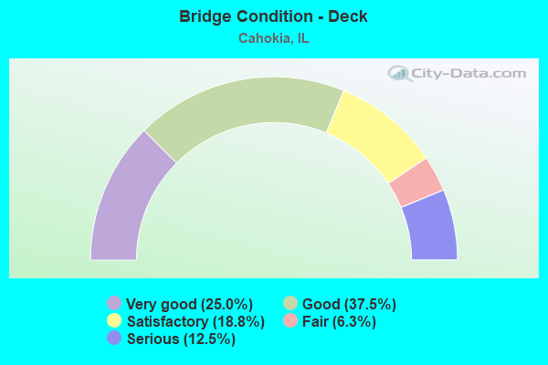
- Bridge Condition - Deck
- 25.0%Very good
- 37.5%Good
- 18.8%Satisfactory
- 6.3%Fair
- 12.5%Serious
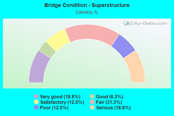
- Bridge Condition - Superstructure
- 18.8%Very good
- 6.3%Good
- 12.5%Satisfactory
- 31.3%Fair
- 12.5%Poor
- 18.8%Serious
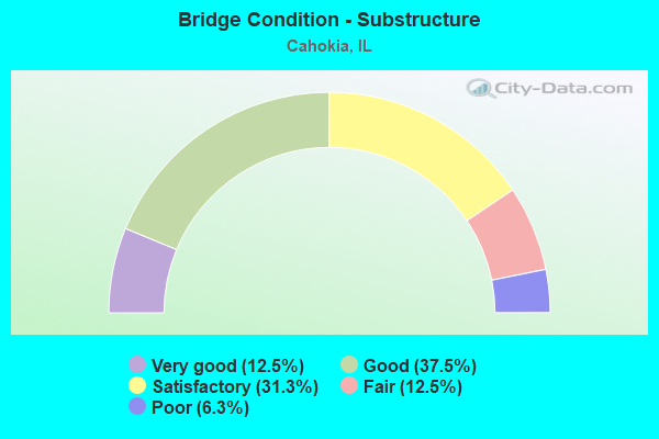
- Bridge Condition - Substructure
- 12.5%Very good
- 37.5%Good
- 31.3%Satisfactory
- 12.5%Fair
- 6.3%Poor
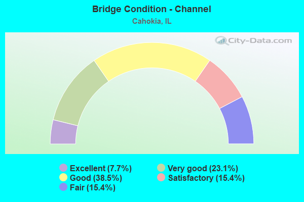
- Bridge Condition - Channel
- 7.7%Excellent
- 23.1%Very good
- 38.5%Good
- 15.4%Satisfactory
- 15.4%Fair
Find on map >> Show street view
Structure Number: 820038, Location: NORTH OF DUPO (Lat: 38.548844, Lng: -90.194406), Route carried "on" structure: State highway 3, Year Built: 2012, Status: Open, Structure Length: 30.03m (98.52ft), Average Daily Traffic: 8,200 (year 2021), Truck Traffic: 18%, Average Future Daily Traffic: 13,075 (year 2032), Design Load: HS 25 or greater, Features Intersected: UPRR & PduPont Canal
Minimum Vertical Clearance: 30+ m (98+ ft), Kilometerpoint: 224.755, Lanes on structure: 4, Base Highway Network: Yes, Owner: State Highway Agency, Approaching Roadway Width: 17.1m (56.1ft), Skew: 30 degrees, Material/Design: Steel continuous, Design/Construction: Stringer/Multi-beam, Number Of Spans In Main Unit: 4, Length of Maximum Span: 100.6m (330.1ft), Curb-To-Curb Width: 17.1m (56.1ft), Out-to-Out Width: 18.0m (59.1ft)
Condition: Deck: Very good, Superstructure: Very good, Substructure: Very good, Channel: Excellent, Operating Rating: 59.6 metric tons, Method Used To Determine Operating Rating: Load and Resistance Factor Rating (LRFR) rating reported by rating factor(RF) method using HL-93 loadings, Inventory Rating: 46.0 metric tons, Method Used To Determine Inventory Rating: Load and Resistance Factor Rating (LRFR) rating reported by rating factor(RF) method using HL-93 loadings, Structural Evaluation: Equal to present desirable criteria, Deck Geometry: Somewhat better than minimum adequacy, Underclear: Superior to present desirable criteria, Waterway Adequacy: Superior to present desirable criteria, Approach Roadway Alignment: Equal to present desirable criteria, Designated Inspection Frequency: Every 24 months, Inspection Date: September 2021, Deck Structure Type: Concrete Cast-file-Place, Wearing Surface/Protective System: Deck Protection: Epoxy Coated Reinforcing
Find on map >> Show street view
Structure Number: 820085, Location: 0.8 M E FAI 255 (Lat: 38.550519, Lng: -90.147522), Route carried "on" structure: State highway 157, Year Built: 1932, Status: Posted for load, Structure Length: 1.16m (3.81ft), Average Daily Traffic: 7,100 (year 2021), Truck Traffic: 8%, Average Future Daily Traffic: 8,734 (year 2032), Features Intersected: GOOSE LAKE CANAL
Minimum Vertical Clearance: 30+ m (98+ ft), Kilometerpoint: 4.699, Lanes on structure: 2, Base Highway Network: Yes, Owner: State Highway Agency, Approaching Roadway Width: 9.1m (29.9ft), Skew: 3 degrees, Material/Design: Concrete, Design/Construction: Tee Beam, Number Of Spans In Main Unit: 1, Length of Maximum Span: 11.1m (36.4ft), Curb-To-Curb Width: 13.1m (43.0ft), Out-to-Out Width: 14.2m (46.6ft)
Condition: Deck: Fair, Superstructure: Fair, Substructure: Satisfactory, Channel: Satisfactory, Operating Rating: 42.1 metric tons, Method Used To Determine Operating Rating: Load Factor (LF) rating reported by rating factor (RF) method using MS18 loading, Inventory Rating: 25.3 metric tons, Method Used To Determine Inventory Rating: Load Factor (LF) rating reported by rating factor (RF) method using MS18 loading, Structural Evaluation: Somewhat better than minimum adequacy, Deck Geometry: Somewhat better than minimum adequacy, Waterway Adequacy: Equal to present minimum criteria, Approach Roadway Alignment: Equal to present desirable criteria, Bridge Posting: Required (Relationship of Operating Rating to Maximum Legal Load: 10.0 - 19.9% below), Designated Inspection Frequency: Every 12 months, Underwater Inspection Frequency: Every 24 months, Inspection Date: June 2021, Underwater Inspection Date: June 2021, Deck Structure Type: Concrete Cast-file-Place
Find on map >> Show street view
Structure Number: 820104, Location: 2.6 M S JCT ILL 157 (Lat: 38.524239, Lng: -90.105025), Route carried "on" structure: State highway 163, Year Built: 1959, Year Reconstructed: 1990, Status: Open, Structure Length: 3.60m (11.81ft), Average Daily Traffic: 3,000 (year 2021), Truck Traffic: 11%, Average Future Daily Traffic: 4,132 (year 2032), Design Load: HS 20, Features Intersected: N PRAIRIE duPONT CR
Minimum Vertical Clearance: 30+ m (98+ ft), Kilometerpoint: 7.210, Lanes on structure: 2, Base Highway Network: Yes, Owner: State Highway Agency, Approaching Roadway Width: 11.0m (36.1ft), Material/Design: Steel continuous, Design/Construction: Stringer/Multi-beam, Number Of Spans In Main Unit: 2, Length of Maximum Span: 19.1m (62.7ft), Curb-To-Curb Width: 9.8m (32.2ft), Out-to-Out Width: 10.7m (35.1ft)
Condition: Deck: Good, Superstructure: Very good, Substructure: Good, Channel: Good, Operating Rating: 52.8 metric tons, Method Used To Determine Operating Rating: Load Factor (LF) rating reported by rating factor (RF) method using MS18 loading, Inventory Rating: 32.4 metric tons, Method Used To Determine Inventory Rating: Load Factor (LF) rating reported by rating factor (RF) method using MS18 loading, Structural Evaluation: Better than present minimum criteria, Deck Geometry: Meets minimum limits, Waterway Adequacy: Equal to present desirable criteria, Approach Roadway Alignment: Equal to present desirable criteria, Designated Inspection Frequency: Every 24 months, Other Special Inspection Frequency: Every 24 months, Inspection Date: August 2021, Other Special Inspection Date: June 2021, Deck Structure Type: Concrete Cast-file-Place, Wearing Surface/Protective System: Deck Protection: Epoxy Coated Reinforcing
Find on map >> Show street view
Structure Number: 82022, Location: .75MI S ILL 157 (Lat: 38.543831, Lng: -90.173192), Route carried "on" structure: Interstate 255, Year Built: 1979, Status: Open, Structure Length: 3.71m (12.17ft), Average Daily Traffic: 33,000 (year 2021), Truck Traffic: 17%, Average Future Daily Traffic: 38,284 (year 2032), Design Load: HS 20+Mod, Features Intersected: STOLLE RD FAU 9208
Minimum Vertical Clearance: 30+ m (98+ ft), Kilometerpoint: 13.647, Lanes on structure: 6, Lanes under structure: 2, Base Highway Network: Yes, Owner: State Highway Agency, Approaching Roadway Width: 34.1m (111.9ft), Skew: 34 degrees, Material/Design: Steel, Design/Construction: Stringer/Multi-beam, Number Of Spans In Main Unit: 1, Length of Maximum Span: 36.9m (121.1ft), Curb-To-Curb Width: 34.1m (111.9ft), Out-to-Out Width: 36.9m (121.1ft)
Condition: Deck: Very good, Superstructure: Serious, Substructure: Fair, Operating Rating: 84.2 metric tons, Method Used To Determine Operating Rating: Load Factor (LF) rating reported by rating factor (RF) method using MS18 loading, Inventory Rating: 50.5 metric tons, Method Used To Determine Inventory Rating: Load Factor (LF) rating reported by rating factor (RF) method using MS18 loading, Structural Evaluation: High priority of corrective action, Deck Geometry: Superior to present desirable criteria, Underclear: Equal to present minimum criteria, Approach Roadway Alignment: Equal to present desirable criteria, Designated Inspection Frequency: Every 12 months, Inspection Date: January 2022, Deck Structure Type: Concrete Cast-file-Place, Wearing Surface/Protective System: Deck Protection: Epoxy Coated Reinforcing
Find on map >> Show street view
Structure Number: 820221, Location: .50 M SW OF ILL 157 (Lat: 38.545619, Lng: -90.170036), Route carried "on" structure: Interstate 255, Year Built: 1981, Status: Open, Structure Length: 72.21m (236.91ft), Average Daily Traffic: 33,000 (year 2021), Truck Traffic: 17%, Average Future Daily Traffic: 38,284 (year 2032), Design Load: HS 20+Mod, Features Intersected: P.DUPONT&BLUE WATERS
Minimum Vertical Clearance: 30+ m (98+ ft), Kilometerpoint: 13.985, Lanes on structure: 6, Base Highway Network: Yes, Owner: State Highway Agency, Approaching Roadway Width: 34.1m (111.9ft), Skew: 35 degrees, Material/Design: Steel continuous, Design/Construction: Stringer/Multi-beam, Number Of Spans In Main Unit: 14, Length of Maximum Span: 61.9m (203.1ft), Curb-To-Curb Width: 34.1m (111.9ft), Out-to-Out Width: 36.9m (121.1ft)
Condition: Deck: Good, Superstructure: Fair, Substructure: Satisfactory, Channel: Very good, Operating Rating: 61.2 metric tons, Method Used To Determine Operating Rating: Load Factor (LF) rating reported by rating factor (RF) method using MS18 loading, Inventory Rating: 36.6 metric tons, Method Used To Determine Inventory Rating: Load Factor (LF) rating reported by rating factor (RF) method using MS18 loading, Structural Evaluation: Somewhat better than minimum adequacy, Deck Geometry: Superior to present desirable criteria, Waterway Adequacy: Superior to present desirable criteria, Approach Roadway Alignment: Equal to present desirable criteria, Designated Inspection Frequency: Every 24 months, Other Special Inspection Frequency: Every 48 months, Inspection Date: January 2021, Other Special Inspection Date: November 2018, Deck Structure Type: Concrete Cast-file-Place, Wearing Surface/Protective System: Deck Protection: Epoxy Coated Reinforcing
Find on map >> Show street view
Structure Number: 820222, Location: 0.50 SO OF DORIS AVE (Lat: 38.550431, Lng: -90.162250), Route carried "on" structure: Interstate 255, Year Built: 1979, Status: Open, Structure Length: 4.75m (15.58ft), Average Daily Traffic: 39,400 (year 2021), Truck Traffic: 18%, Average Future Daily Traffic: 40,480 (year 2032), Design Load: HS 20+Mod, Features Intersected: ILL 157
Minimum Vertical Clearance: 30+ m (98+ ft), Kilometerpoint: 14.854, Lanes on structure: 6, Lanes under structure: 5, Base Highway Network: Yes, Owner: State Highway Agency, Approaching Roadway Width: 34.1m (111.9ft), Skew: 30 degrees, Material/Design: Steel continuous, Design/Construction: Stringer/Multi-beam, Number Of Spans In Main Unit: 2, Length of Maximum Span: 25.9m (85.0ft), Curb-To-Curb Width: 44.0m (144.4ft), Out-to-Out Width: 44.9m (147.3ft)
Condition: Deck: Good, Superstructure: Fair, Substructure: Satisfactory, Operating Rating: 74.8 metric tons, Method Used To Determine Operating Rating: Load Factor (LF) rating reported by rating factor (RF) method using MS18 loading, Inventory Rating: 44.7 metric tons, Method Used To Determine Inventory Rating: Load Factor (LF) rating reported by rating factor (RF) method using MS18 loading, Structural Evaluation: Somewhat better than minimum adequacy, Deck Geometry: Superior to present desirable criteria, Underclear: Equal to present minimum criteria, Approach Roadway Alignment: Equal to present desirable criteria, Designated Inspection Frequency: Every 24 months, Inspection Date: January 2021, Deck Structure Type: Concrete Cast-file-Place, Wearing Surface/Protective System: Deck Protection: Epoxy Coated Reinforcing
Find on map >> Show street view
Structure Number: 820223, Location: 0.5 M N OF ILL 157 (Lat: 38.555081, Lng: -90.155211), Route carried "on" structure: Interstate 255, Year Built: 1979, Status: Open, Structure Length: 3.30m (10.83ft), Average Daily Traffic: 39,400 (year 2021), Truck Traffic: 18%, Average Future Daily Traffic: 40,480 (year 2032), Design Load: HS 20+Mod, Features Intersected: DORIS AVE/FAU 9199
Minimum Vertical Clearance: 30+ m (98+ ft), Kilometerpoint: 15.642, Lanes on structure: 6, Lanes under structure: 2, Base Highway Network: Yes, Owner: State Highway Agency, Approaching Roadway Width: 34.1m (111.9ft), Skew: 32 degrees, Material/Design: Steel, Design/Construction: Stringer/Multi-beam, Number Of Spans In Main Unit: 1, Number Of Approach Spans: 2, Length of Maximum Span: 32.3m (106.0ft), Curb-To-Curb Width: 36.4m (119.4ft), Out-to-Out Width: 37.2m (122.0ft)
Condition: Deck: Good, Superstructure: Fair, Substructure: Good, Operating Rating: 75.5 metric tons, Method Used To Determine Operating Rating: Load Factor (LF) rating reported by rating factor (RF) method using MS18 loading, Inventory Rating: 45.0 metric tons, Method Used To Determine Inventory Rating: Load Factor (LF) rating reported by rating factor (RF) method using MS18 loading, Structural Evaluation: Somewhat better than minimum adequacy, Deck Geometry: Superior to present desirable criteria, Underclear: Somewhat better than minimum adequacy, Approach Roadway Alignment: Equal to present desirable criteria, Designated Inspection Frequency: Every 24 months, Inspection Date: January 2021, Deck Structure Type: Concrete Cast-file-Place, Wearing Surface/Protective System: Deck Protection: Epoxy Coated Reinforcing
Find on map >> Show street view
Structure Number: 820224, Location: 0.5 Mi N OF IL 157 (Lat: 38.557050, Lng: -90.147819), Route carried "on" structure: Interstate 255, Year Built: 1979, Status: Open, Structure Length: 3.30m (10.83ft), Average Daily Traffic: 39,400 (year 2021), Truck Traffic: 18%, Average Future Daily Traffic: 40,480 (year 2032), Design Load: HS 20+Mod, Features Intersected: JEROME LA FAU 9197
Minimum Vertical Clearance: 30+ m (98+ ft), Kilometerpoint: 16.334, Lanes on structure: 6, Lanes under structure: 2, Base Highway Network: Yes, Owner: State Highway Agency, Approaching Roadway Width: 34.1m (111.9ft), Skew: 32 degrees, Material/Design: Steel, Design/Construction: Stringer/Multi-beam, Number Of Spans In Main Unit: 1, Number Of Approach Spans: 2, Length of Maximum Span: 32.3m (106.0ft), Curb-To-Curb Width: 34.9m (114.5ft), Out-to-Out Width: 37.1m (121.7ft)
Condition: Deck: Very good, Superstructure: Satisfactory, Substructure: Good, Operating Rating: 85.2 metric tons, Method Used To Determine Operating Rating: Load Factor (LF) rating reported by rating factor (RF) method using MS18 loading, Inventory Rating: 50.9 metric tons, Method Used To Determine Inventory Rating: Load Factor (LF) rating reported by rating factor (RF) method using MS18 loading, Structural Evaluation: Equal to present minimum criteria, Deck Geometry: Superior to present desirable criteria, Underclear: Meets minimum limits, Approach Roadway Alignment: Equal to present desirable criteria, Designated Inspection Frequency: Every 24 months, Inspection Date: January 2021, Deck Structure Type: Concrete Cast-file-Place, Wearing Surface/Protective System: Deck Protection: Epoxy Coated Reinforcing
Find on map >> Show street view
Structure Number: 820225, Location: 0.5 M S MOUSETTE LN (Lat: 38.558439, Lng: -90.143097), Route carried "on" structure: Interstate 255, Year Built: 1982, Status: Open, Structure Length: 1.16m (3.81ft), Average Daily Traffic: 39,400 (year 2021), Truck Traffic: 18%, Average Future Daily Traffic: 40,480 (year 2032), Design Load: HS 20+Mod, Features Intersected: GOOSE LAKE DITCH
Minimum Vertical Clearance: 30+ m (98+ ft), Kilometerpoint: 16.737, Lanes on structure: 6, Base Highway Network: Yes, Owner: State Highway Agency, Approaching Roadway Width: 34.1m (111.9ft), Skew: 33 degrees, Material/Design: Concrete continuous, Design/Construction: Culvert, Number Of Spans In Main Unit: 3, Length of Maximum Span: 3.9m (12.8ft)
Condition: Channel: Very good, Culverts: Good, Operating Rating: 97.2 metric tons, Method Used To Determine Operating Rating: Load Factor (LF) rating reported by rating factor (RF) method using MS18 loading, Inventory Rating: 97.2 metric tons, Method Used To Determine Inventory Rating: Load Factor (LF) rating reported by rating factor (RF) method using MS18 loading, Structural Evaluation: Better than present minimum criteria, Waterway Adequacy: Equal to present desirable criteria, Approach Roadway Alignment: Equal to present desirable criteria, Designated Inspection Frequency: Every 24 months, Inspection Date: January 2021
Find on map >> Show street view
Structure Number: 820263, Location: 0.50 MI S DORIS AVE (Lat: 38.549006, Lng: -90.161344), Route carried "on" structure: Other road , Year Built: 1980, Status: Open, Structure Length: 25.39m (83.30ft), Average Daily Traffic: 2,800 (year 2018), Truck Traffic: 12%, Average Future Daily Traffic: 1,151 (year 2032), Design Load: HS 20, Features Intersected: BLUE WATERS DITCH, Facility Carried by Structure: I-255 RAMP E
Minimum Vertical Clearance: 30+ m (98+ ft), Kilometerpoint: 0.402, Lanes on structure: 1, Base Highway Network: Yes (Inventory Route: 10255040, Subroute: 70), Owner: State Highway Agency, Approaching Roadway Width: 8.1m (26.6ft), Material/Design: Steel continuous, Design/Construction: Stringer/Multi-beam, Number Of Spans In Main Unit: 8, Length of Maximum Span: 34.1m (111.9ft), Curb-To-Curb Width: 7.9m (25.9ft), Out-to-Out Width: 8.9m (29.2ft)
Condition: Deck: Satisfactory, Superstructure: Fair, Substructure: Good, Channel: Good, Operating Rating: 69.0 metric tons, Method Used To Determine Operating Rating: Load Factor (LF) rating reported by rating factor (RF) method using MS18 loading, Inventory Rating: 41.5 metric tons, Method Used To Determine Inventory Rating: Load Factor (LF) rating reported by rating factor (RF) method using MS18 loading, Structural Evaluation: Somewhat better than minimum adequacy, Deck Geometry: High priority of corrective action, Waterway Adequacy: Superior to present desirable criteria, Approach Roadway Alignment: Equal to present minimum criteria, Designated Inspection Frequency: Every 24 months, Inspection Date: January 2021, Deck Structure Type: Concrete Cast-file-Place, Wearing Surface/Protective System: Deck Protection: Epoxy Coated Reinforcing
Find on map >> Show street view
Structure Number: 820273, Location: 1.5M S ILL 157 (Lat: 38.552156, Lng: -90.201303), Route carried "on" structure: Other road , Year Built: 1984, Status: Open, Structure Length: 10.70m (35.10ft), Average Daily Traffic: 1,700 (year 2018), Truck Traffic: 8%, Average Future Daily Traffic: 2,354 (year 2032), Design Load: HS 20, Features Intersected: Prairie duPont Canal, Facility Carried by Structure: FAU 9206-WATER ST
Minimum Vertical Clearance: 30+ m (98+ ft), Kilometerpoint: 1.883, Lanes on structure: 2, Owner: State Highway Agency, Approaching Roadway Width: 6.7m (22.0ft), Skew: 2 degrees, Material/Design: Steel continuous, Design/Construction: Stringer/Multi-beam, Number Of Spans In Main Unit: 3, Length of Maximum Span: 41.8m (137.1ft), Curb-To-Curb Width: 8.5m (27.9ft), Out-to-Out Width: 9.5m (31.2ft)
Condition: Deck: Good, Superstructure: Satisfactory, Substructure: Good, Channel: Good, Operating Rating: 55.1 metric tons, Method Used To Determine Operating Rating: Load Factor (LF) rating reported by rating factor (RF) method using MS18 loading, Inventory Rating: 33.4 metric tons, Method Used To Determine Inventory Rating: Load Factor (LF) rating reported by rating factor (RF) method using MS18 loading, Structural Evaluation: Equal to present minimum criteria, Deck Geometry: Somewhat better than minimum adequacy, Waterway Adequacy: Better than present minimum criteria, Approach Roadway Alignment: Equal to present minimum criteria, Designated Inspection Frequency: Every 24 months, Inspection Date: August 2020, Deck Structure Type: Concrete Cast-file-Place, Wearing Surface/Protective System: Deck Protection: Epoxy Coated Reinforcing
Find on map >> Show street view
Structure Number: 820303, Location: IL 157CAHOKIA E OF 3 (Lat: 38.565636, Lng: -90.178906), Route carried "on" structure: State highway 157, Year Built: 2009, Status: Open, Structure Length: 5.04m (16.54ft), Average Daily Traffic: 12,500 (year 2021), Truck Traffic: 6%, Average Future Daily Traffic: 12,970 (year 2032), Design Load: HS 20, Features Intersected: UP RAILROAD
Minimum Vertical Clearance: 30+ m (98+ ft), Kilometerpoint: 1.094, Lanes on structure: 4, Base Highway Network: Yes, Owner: State Highway Agency, Approaching Roadway Width: 18.0m (59.1ft), Skew: 30 degrees, Material/Design: Steel continuous, Design/Construction: Stringer/Multi-beam, Number Of Spans In Main Unit: 3, Length of Maximum Span: 21.2m (69.6ft), Curb or Sidewalk Widths: Left: 0.0m, Right: 1.5m (4.9ft), Curb-To-Curb Width: 23.0m (75.5ft), Out-to-Out Width: 25.3m (83.0ft)
Condition: Deck: Very good, Superstructure: Very good, Substructure: Very good, Operating Rating: 89.1 metric tons, Method Used To Determine Operating Rating: Load Factor (LF) rating reported by rating factor (RF) method using MS18 loading, Inventory Rating: 54.4 metric tons, Method Used To Determine Inventory Rating: Load Factor (LF) rating reported by rating factor (RF) method using MS18 loading, Structural Evaluation: Equal to present desirable criteria, Deck Geometry: Superior to present desirable criteria, Underclear: Superior to present desirable criteria, Approach Roadway Alignment: Equal to present desirable criteria, Designated Inspection Frequency: Every 48 months, Inspection Date: June 2021, Deck Structure Type: Concrete Cast-file-Place, Wearing Surface/Protective System: Deck Protection: Epoxy Coated Reinforcing
Find on map >> Show street view
Structure Number: 823086, Location: .10 MI S ILL 157 (Lat: 38.548497, Lng: -90.160311), Route carried "on" structure: Other road , Year Built: 1992, Status: Open, Structure Length: 7.34m (24.08ft), Average Daily Traffic: 2,550 (year 2018), Truck Traffic: 16%, Average Future Daily Traffic: 4,812 (year 2032), Design Load: HS 20, Features Intersected: PRAIRIE DUPONT CK, Facility Carried by Structure: FAU 9218
Minimum Vertical Clearance: 30+ m (98+ ft), Kilometerpoint: 0.097, Lanes on structure: 2, Base Highway Network: Yes, Owner: County Highway Agency, Approaching Roadway Width: 7.3m (24.0ft), Material/Design: Prestressed concrete, Design/Construction: Box Beam or Girders - Multiple, Number Of Spans In Main Unit: 3, Length of Maximum Span: 24.4m (80.1ft), Curb-To-Curb Width: 9.1m (29.9ft), Out-to-Out Width: 9.1m (29.9ft)
Condition: Deck: Serious, Superstructure: Serious, Substructure: Good, Channel: Good, Operating Rating: 62.2 metric tons, Method Used To Determine Operating Rating: Load Factor (LF) rating reported by rating factor (RF) method using MS18 loading, Inventory Rating: 31.8 metric tons, Method Used To Determine Inventory Rating: Load Factor (LF) rating reported by rating factor (RF) method using MS18 loading, Structural Evaluation: High priority of corrective action, Deck Geometry: Meets minimum limits, Waterway Adequacy: Superior to present desirable criteria, Approach Roadway Alignment: Equal to present desirable criteria, Length Of Structure Improvement: 7.32m (24.02ft), Designated Inspection Frequency: Every 24 months, Other Special Inspection Frequency: Every 12 months, Inspection Date: Febuary 2020, Other Special Inspection Date: October 2021, Bridge Improvement Cost: $1,080,000, Roadway Improvement Cost: $45,000, Total Project Cost: $1,125,000, Deck Structure Type: Concrete Precast Panels
Find on map >> Show street view
Structure Number: 823094, Location: 2.0 MI W IL 163 (Lat: 38.519625, Lng: -90.142278), Route carried "on" structure: County highway , Year Built: 1997, Status: Posted for load, Structure Length: 5.18m (16.99ft), Average Daily Traffic: 775 (year 2021), Truck Traffic: 6%, Average Future Daily Traffic: 994 (year 2032), Design Load: HS 20, Features Intersected: PRAIRIE DUPONT CK, Facility Carried by Structure: IMBS STATION RD
Minimum Vertical Clearance: 30+ m (98+ ft), Kilometerpoint: 7.371, Lanes on structure: 2, Owner: County Highway Agency, Approaching Roadway Width: 9.7m (31.8ft), Skew: 1 degrees, Material/Design: Prestressed concrete, Design/Construction: Box Beam or Girders - Multiple, Number Of Spans In Main Unit: 3, Length of Maximum Span: 18.0m (59.1ft), Curb-To-Curb Width: 9.8m (32.2ft), Out-to-Out Width: 9.8m (32.2ft)
Condition: Deck: Serious, Superstructure: Serious, Substructure: Poor, Channel: Good, Operating Rating: 9.4 metric tons, Method Used To Determine Operating Rating: Load Factor (LF) rating reported by rating factor (RF) method using MS18 loading, Inventory Rating: 3.6 metric tons, Method Used To Determine Inventory Rating: Load Factor (LF) rating reported by rating factor (RF) method using MS18 loading, Structural Evaluation: High priority of corrective action, Deck Geometry: Equal to present minimum criteria, Waterway Adequacy: Superior to present desirable criteria, Approach Roadway Alignment: Equal to present desirable criteria, Bridge Posting: Required (Relationship of Operating Rating to Maximum Legal Load: > 39.9% below), Designated Inspection Frequency: Every 24 months, Other Special Inspection Frequency: Every 3 months, Inspection Date: March 2021, Other Special Inspection Date: September 2021, Deck Structure Type: Concrete Precast Panels, Wearing Surface/Protective System: Wearing Surface: Bituminous, Membrane: Built-up
Find on map >> Show street view
Structure Number: 82403, Location: 0.4 MI S CH 40 (Lat: 38.513244, Lng: -90.145556), Route carried "on" structure: County highway , Year Built: 1971, Status: Open, Structure Length: 2.32m (7.61ft), Average Daily Traffic: 325 (year 2018), Truck Traffic: 10%, Average Future Daily Traffic: 392 (year 2032), Design Load: HS 15, Features Intersected: SPARROW CR, Facility Carried by Structure: WAGNER RD/ TR 40
Minimum Vertical Clearance: 30+ m (98+ ft), Kilometerpoint: 0.595, Lanes on structure: 2, Owner: Town or Township Highway Agency, Approaching Roadway Width: 7.3m (24.0ft), Material/Design: Concrete, Design/Construction: Channel Beam, Number Of Spans In Main Unit: 3, Length of Maximum Span: 8.5m (27.9ft), Curb-To-Curb Width: 8.5m (27.9ft), Out-to-Out Width: 9.1m (29.9ft)
Condition: Deck: Satisfactory, Superstructure: Poor, Substructure: Satisfactory, Channel: Fair, Operating Rating: 69.3 metric tons, Method Used To Determine Operating Rating: Load Factor (LF) rating reported by rating factor (RF) method using MS18 loading, Inventory Rating: 26.9 metric tons, Method Used To Determine Inventory Rating: Load Factor (LF) rating reported by rating factor (RF) method using MS18 loading, Structural Evaluation: Meets minimum limits, Deck Geometry: Equal to present minimum criteria, Waterway Adequacy: Equal to present desirable criteria, Approach Roadway Alignment: Equal to present desirable criteria, Designated Inspection Frequency: Every 24 months, Inspection Date: Febuary 2021, Deck Structure Type: Concrete Precast Panels, Wearing Surface/Protective System: Wearing Surface: Gravel
Find on map >> Show street view
Structure Number: 824099, Location: 0.2 MI E WAGNER RD (Lat: 38.513831, Lng: -90.142422), Route carried "on" structure: County highway , Year Built: 1978, Status: Open, Structure Length: 3.05m (10.01ft), Average Daily Traffic: 250 (year 2018), Truck Traffic: 12%, Average Future Daily Traffic: 209 (year 2032), Design Load: HS 20, Features Intersected: HICKMAN CREEK, Facility Carried by Structure: OTTEN RD/ TR 107
Minimum Vertical Clearance: 30+ m (98+ ft), Kilometerpoint: 0.274, Lanes on structure: 2, Owner: Town or Township Highway Agency, Approaching Roadway Width: 6.1m (20.0ft), Material/Design: Concrete, Design/Construction: Channel Beam, Number Of Spans In Main Unit: 3, Length of Maximum Span: 11.6m (38.1ft), Curb-To-Curb Width: 8.5m (27.9ft), Out-to-Out Width: 9.2m (30.2ft)
Condition: Deck: Satisfactory, Superstructure: Poor, Substructure: Satisfactory, Channel: Satisfactory, Operating Rating: 52.5 metric tons, Method Used To Determine Operating Rating: Load Factor (LF) rating reported by rating factor (RF) method using MS18 loading, Inventory Rating: 31.4 metric tons, Method Used To Determine Inventory Rating: Load Factor (LF) rating reported by rating factor (RF) method using MS18 loading, Structural Evaluation: Meets minimum limits, Deck Geometry: Equal to present minimum criteria, Waterway Adequacy: Better than present minimum criteria, Approach Roadway Alignment: Equal to present desirable criteria, Designated Inspection Frequency: Every 24 months, Inspection Date: Febuary 2021, Deck Structure Type: Concrete Precast Panels
Find on map >> Show street view
Structure Number: 8266, Location: 1.25 MI NE CH 39 (Lat: 38.540669, Lng: -90.150828), Route carried "on" structure: City street , Year Built: 1995, Status: Open, Structure Length: 2.51m (8.23ft), Average Daily Traffic: 75 (year 2018), Truck Traffic: 13%, Average Future Daily Traffic: 166 (year 2032), Design Load: HS 20, Features Intersected: PRAIRIE DU PONT, Facility Carried by Structure: MULLINS CREEK RD
Minimum Vertical Clearance: 30+ m (98+ ft), Kilometerpoint: 0.016, Lanes on structure: 2, Owner: City or Municipal Highway Agency, Approaching Roadway Width: 5.5m (18.0ft), Material/Design: Prestressed concrete, Design/Construction: Box Beam or Girders - Multiple, Number Of Spans In Main Unit: 1, Length of Maximum Span: 24.4m (80.1ft), Curb-To-Curb Width: 8.3m (27.2ft), Out-to-Out Width: 8.3m (27.2ft)
Condition: Deck: Good, Superstructure: Good, Substructure: Fair, Channel: Fair, Operating Rating: 58.6 metric tons, Method Used To Determine Operating Rating: Load Factor (LF) rating reported by rating factor (RF) method using MS18 loading, Inventory Rating: 32.4 metric tons, Method Used To Determine Inventory Rating: Load Factor (LF) rating reported by rating factor (RF) method using MS18 loading, Structural Evaluation: Somewhat better than minimum adequacy, Deck Geometry: Equal to present minimum criteria, Waterway Adequacy: Better than present minimum criteria, Approach Roadway Alignment: Meets minimum limits, Designated Inspection Frequency: Every 24 months, Inspection Date: April 2020, Deck Structure Type: Concrete Precast Panels, Wearing Surface/Protective System: Wearing Surface: Bituminous
Find on map >> Show street view
Structure Number: 828, Location: 0.1 MI E JEROME LA (Lat: 38.554522, Lng: -90.145625), Route carried "on" structure: Other road , Year Built: 1989, Status: Open, Structure Length: 1.46m (4.79ft), Average Daily Traffic: 1,400 (year 2018), Truck Traffic: 11%, Average Future Daily Traffic: 2,458 (year 2032), Features Intersected: GOOSE LAKE DITCH, Facility Carried by Structure: MOUSETTE LA/FAU 92
Minimum Vertical Clearance: 30+ m (98+ ft), Kilometerpoint: 4.715, Lanes on structure: 2, Owner: City or Municipal Highway Agency, Approaching Roadway Width: 12.2m (40.0ft), Material/Design: Concrete, Design/Construction: Culvert, Number Of Spans In Main Unit: 4, Length of Maximum Span: 2.4m (7.9ft), Curb-To-Curb Width: 9.1m (29.9ft), Out-to-Out Width: 9.4m (30.8ft)
Condition: Channel: Very good, Culverts: Good, Operating Rating: 53.8 metric tons, Method Used To Determine Operating Rating: Field evaluation and documented engineering judgment, Inventory Rating: 32.4 metric tons, Method Used To Determine Inventory Rating: Field evaluation and documented engineering judgment, Structural Evaluation: Better than present minimum criteria, Deck Geometry: Somewhat better than minimum adequacy, Waterway Adequacy: Equal to present desirable criteria, Approach Roadway Alignment: Equal to present desirable criteria, Designated Inspection Frequency: Every 48 months, Inspection Date: May 2018, Wearing Surface/Protective System: Wearing Surface: Other
Find on map >> Show street view
Structure Number: 82022, Location: .75MI S ILL 157 (Lat: 38.543831, Lng: -90.173192), Route carried "under" structure: Other road , Year Built: 1979, Structure Length: 0. m, Average Daily Traffic: 1,600 (year 2021), Truck Traffic: 20%, Features Intersected: STOLLE RD FAU 9208, Facility Carried by Structure: FAI 255
Minimum Vertical Clearance: 4.50m (14.76ft), Kilometerpoint: 1.996, Lanes on structure: 6, Lanes under structure: 2, Material/Design: Steel, Design/Construction: Stringer/Multi-beam, Length of Maximum Span: 36.9m (121.1ft)
Find on map >> Show street view
Structure Number: 820222, Location: 0.50 SO OF DORIS AVE (Lat: 38.550431, Lng: -90.162250), Route carried "under" structure: State highway 157, Year Built: 1979, Structure Length: 0. m, Average Daily Traffic: 8,750 (year 2021), Truck Traffic: 6%, Features Intersected: ILL 157, Facility Carried by Structure: FAI 255
Minimum Vertical Clearance: 5.21m (17.09ft), Kilometerpoint: 3.315, Lanes on structure: 6, Lanes under structure: 5, Material/Design: Steel continuous, Design/Construction: Stringer/Multi-beam, Length of Maximum Span: 25.9m (85.0ft)
Find on map >> Show street view
Structure Number: 820223, Location: 0.5 M N OF ILL 157 (Lat: 38.555081, Lng: -90.155211), Route carried "under" structure: Other road , Year Built: 1979, Structure Length: 0. m, Average Daily Traffic: 900 (year 2018), Truck Traffic: 5%, Features Intersected: DORIS AVE/FAU 9199, Facility Carried by Structure: FAI 255
Minimum Vertical Clearance: 4.42m (14.50ft), Kilometerpoint: 1.529, Lanes on structure: 6, Lanes under structure: 2, Material/Design: Steel, Design/Construction: Stringer/Multi-beam, Length of Maximum Span: 32.3m (106.0ft)
Find on map >> Show street view
Structure Number: 820224, Location: 0.5 Mi N OF IL 157 (Lat: 38.557050, Lng: -90.147819), Route carried "under" structure: Other road , Year Built: 1979, Structure Length: 0. m, Average Daily Traffic: 1,650 (year 2018), Truck Traffic: 8%, Features Intersected: JEROME LA FAU 9197, Facility Carried by Structure: FAI 255
Minimum Vertical Clearance: 4.45m (14.60ft), Kilometerpoint: 4.055, Lanes on structure: 6, Lanes under structure: 2, Material/Design: Steel, Design/Construction: Stringer/Multi-beam, Length of Maximum Span: 32.3m (106.0ft)