Bridge Statistics for Cairo, Illinois (IL)
Condition, Traffic, Stress, Structural Evaluation, Project Costs
- National Bridge Inventory (NBI) Statistics
- 24Number of bridges
- 2,635ft / 803mTotal length
- $58,963,000Total costs
- 107,620Total average daily traffic
- 40,175Total average daily truck traffic
- National Bridge Inventory (NBI) Registered Bridges for Cairo
- No street view available for this location
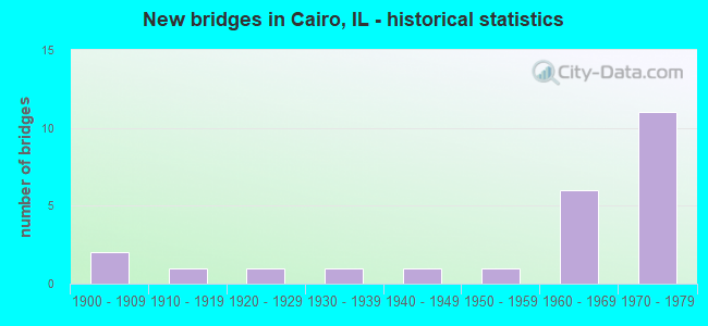
- New bridges - historical statistics
- 21900-1909
- 11910-1919
- 11920-1929
- 11930-1939
- 11940-1949
- 11950-1959
- 61960-1969
- 111970-1979
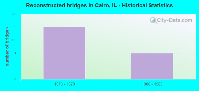
- Reconstructed bridges - Historical Statistics
- 21970-1979
- 11980-1989
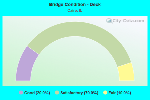
- Bridge Condition - Deck
- 20.0%Good
- 70.0%Satisfactory
- 10.0%Fair
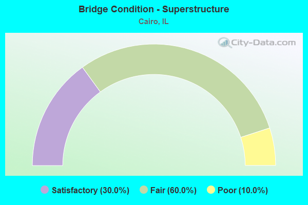
- Bridge Condition - Superstructure
- 30.0%Satisfactory
- 60.0%Fair
- 10.0%Poor
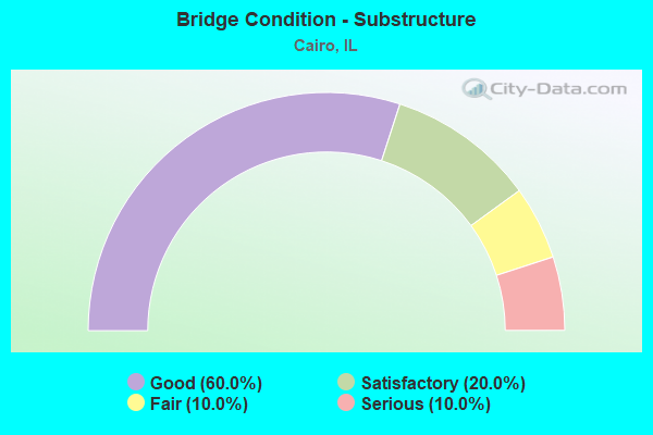
- Bridge Condition - Substructure
- 60.0%Good
- 20.0%Satisfactory
- 10.0%Fair
- 10.0%Serious
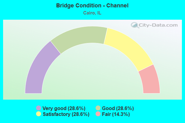
- Bridge Condition - Channel
- 28.6%Very good
- 28.6%Good
- 28.6%Satisfactory
- 14.3%Fair
Find on map >> Show street view
Structure Number: 20001, Location: 0.3 MI S PULASKI CO (Lat: 37.077281, Lng: -89.188400), Route carried "on" structure: Interstate 57, Year Built: 1968, Status: Open, Structure Length: 52.06m (170.80ft), Average Daily Traffic: 6,700 (year 2021), Truck Traffic: 49%, Average Future Daily Traffic: 5,704 (year 2032), Design Load: HS 20+Mod, Features Intersected: TR-163B
Minimum Vertical Clearance: 30+ m (98+ ft), Kilometerpoint: 6.260, Lanes on structure: 2, Lanes under structure: 2, Base Highway Network: Yes, Owner: State Highway Agency, Approaching Roadway Width: 11.0m (36.1ft), Skew: 4 degrees, Material/Design: Prestressed concrete continuous, Design/Construction: Stringer/Multi-beam, Number Of Spans In Main Unit: 25, Number Of Approach Spans: 3, Length of Maximum Span: 20.0m (65.6ft), Curb-To-Curb Width: 9.9m (32.5ft), Out-to-Out Width: 10.9m (35.8ft)
Condition: Deck: Satisfactory, Superstructure: Fair, Substructure: Satisfactory, Operating Rating: 58.0 metric tons, Method Used To Determine Operating Rating: Load Factor (LF) rating reported by rating factor (RF) method using MS18 loading, Inventory Rating: 34.7 metric tons, Method Used To Determine Inventory Rating: Load Factor (LF) rating reported by rating factor (RF) method using MS18 loading, Structural Evaluation: Somewhat better than minimum adequacy, Deck Geometry: Meets minimum limits, Underclear: High priority of corrective action, Approach Roadway Alignment: Equal to present desirable criteria, Designated Inspection Frequency: Every 24 months, Inspection Date: July 2021, Deck Structure Type: Concrete Cast-file-Place, Wearing Surface/Protective System: Wearing Surface: Other
Find on map >> Show street view
Structure Number: 20002, Location: 0.3 MI S PULASKI CO (Lat: 37.077369, Lng: -89.188400), Route carried "on" structure: Interstate 57, Year Built: 1968, Status: Open, Structure Length: 53.95m (177.00ft), Average Daily Traffic: 6,700 (year 2021), Truck Traffic: 49%, Average Future Daily Traffic: 5,704 (year 2032), Design Load: HS 20+Mod, Features Intersected: TR 163B GOLDEN LILLY
Minimum Vertical Clearance: 30+ m (98+ ft), Kilometerpoint: 6.276, Lanes on structure: 2, Lanes under structure: 2, Base Highway Network: Yes, Owner: State Highway Agency, Approaching Roadway Width: 11.0m (36.1ft), Skew: 4 degrees, Material/Design: Prestressed concrete continuous, Design/Construction: Stringer/Multi-beam, Number Of Spans In Main Unit: 26, Number Of Approach Spans: 3, Length of Maximum Span: 20.0m (65.6ft), Curb-To-Curb Width: 9.9m (32.5ft), Out-to-Out Width: 10.9m (35.8ft)
Condition: Deck: Satisfactory, Superstructure: Satisfactory, Substructure: Good, Operating Rating: 28.8 metric tons, Method Used To Determine Operating Rating: Load and Resistance Factor Rating (LRFR) rating reported by rating factor(RF) method using HL-93 loadings, Inventory Rating: 22.0 metric tons, Method Used To Determine Inventory Rating: Load and Resistance Factor Rating (LRFR) rating reported by rating factor(RF) method using HL-93 loadings, Structural Evaluation: Somewhat better than minimum adequacy, Deck Geometry: Meets minimum limits, Underclear: Superior to present desirable criteria, Approach Roadway Alignment: Equal to present desirable criteria, Length Of Structure Improvement: 53.95m (177.00ft), Designated Inspection Frequency: Every 24 months, Inspection Date: July 2021, Bridge Improvement Cost: $3,813,000, Roadway Improvement Cost: $381,000, Total Project Cost: $5,720,000, Deck Structure Type: Concrete Cast-file-Place, Wearing Surface/Protective System: Wearing Surface: Other
Find on map >> Show street view
Structure Number: 20003, Location: PULASKI CO LINE (Lat: 37.080069, Lng: -89.188336), Route carried "on" structure: Interstate 57, Year Built: 1967, Status: Open, Structure Length: 21.76m (71.39ft), Average Daily Traffic: 6,700 (year 2021), Truck Traffic: 49%, Average Future Daily Traffic: 5,704 (year 2032), Design Load: HS 20+Mod, Features Intersected: CACHE RIVER
Minimum Vertical Clearance: 30+ m (98+ ft), Kilometerpoint: 6.759, Lanes on structure: 2, Base Highway Network: Yes, Owner: State Highway Agency, Approaching Roadway Width: 11.0m (36.1ft), Skew: 4 degrees, Material/Design: Steel continuous, Design/Construction: Girder and Floorbeam System, Number Of Spans In Main Unit: 3, Number Of Approach Spans: 5, Length of Maximum Span: 56.7m (186.0ft), Curb-To-Curb Width: 9.9m (32.5ft), Out-to-Out Width: 10.9m (35.8ft)
Condition: Deck: Satisfactory, Superstructure: Satisfactory, Substructure: Good, Channel: Very good, Operating Rating: 49.6 metric tons, Method Used To Determine Operating Rating: Load Factor (LF) rating reported by rating factor (RF) method using MS18 loading, Inventory Rating: 29.8 metric tons, Method Used To Determine Inventory Rating: Load Factor (LF) rating reported by rating factor (RF) method using MS18 loading, Structural Evaluation: Equal to present minimum criteria, Deck Geometry: Meets minimum limits, Waterway Adequacy: Equal to present desirable criteria, Approach Roadway Alignment: Equal to present desirable criteria, Designated Inspection Frequency: Every 24 months, Critical Feature Inspection Frequency: Every 24 months, Underwater Inspection Frequency: Every 60 months, Inspection Date: March 2021, Critical Feature Inspection Date: March 2021, Underwater Inspection Date: June 2020, Deck Structure Type: Concrete Cast-file-Place, Wearing Surface/Protective System: Wearing Surface: Other
Find on map >> Show street view
Structure Number: 20004, Location: PULASKI CO LINE (Lat: 37.080161, Lng: -89.188333), Route carried "on" structure: Interstate 57, Year Built: 1967, Status: Open, Structure Length: 21.76m (71.39ft), Average Daily Traffic: 6,700 (year 2021), Truck Traffic: 49%, Average Future Daily Traffic: 5,704 (year 2032), Design Load: HS 20+Mod, Features Intersected: CACHE RIVER
Minimum Vertical Clearance: 30+ m (98+ ft), Kilometerpoint: 6.775, Lanes on structure: 2, Base Highway Network: Yes, Owner: State Highway Agency, Approaching Roadway Width: 11.0m (36.1ft), Skew: 4 degrees, Material/Design: Steel continuous, Design/Construction: Girder and Floorbeam System, Number Of Spans In Main Unit: 3, Number Of Approach Spans: 5, Length of Maximum Span: 56.7m (186.0ft), Curb-To-Curb Width: 9.9m (32.5ft), Out-to-Out Width: 10.9m (35.8ft)
Condition: Deck: Satisfactory, Superstructure: Satisfactory, Substructure: Good, Channel: Good, Operating Rating: 49.6 metric tons, Method Used To Determine Operating Rating: Load Factor (LF) rating reported by rating factor (RF) method using MS18 loading, Inventory Rating: 29.8 metric tons, Method Used To Determine Inventory Rating: Load Factor (LF) rating reported by rating factor (RF) method using MS18 loading, Structural Evaluation: Equal to present minimum criteria, Deck Geometry: Meets minimum limits, Waterway Adequacy: Equal to present desirable criteria, Approach Roadway Alignment: Equal to present desirable criteria, Designated Inspection Frequency: Every 24 months, Critical Feature Inspection Frequency: Every 24 months, Underwater Inspection Frequency: Every 60 months, Inspection Date: March 2021, Critical Feature Inspection Date: March 2021, Underwater Inspection Date: June 2020, Deck Structure Type: Concrete Cast-file-Place, Wearing Surface/Protective System: Wearing Surface: Other
Find on map >> Show street view
Structure Number: 20005, Location: CAIRO (Lat: 36.986214, Lng: -89.150244), Route carried "on" structure: US 60, Year Built: 1929, Year Reconstructed: 1983, Status: Posted for load, Structure Length: 157.93m (518.14ft), Average Daily Traffic: 3,400 (year 2021), Truck Traffic: 18%, Average Future Daily Traffic: 5,029 (year 2032), Design Load: H 15, Features Intersected: MISSISSIPPI R
Minimum Vertical Clearance: 5.46m (17.91ft), Kilometerpoint: 0.885, Lanes on structure: 2, Owner: State Highway Agency, Approaching Roadway Width: 7.3m (24.0ft), Navigation Control: Yes ( Vertical Clearance: 18.9m (62.0ft), Horizontal Clearance: 205.7m (674.9ft)), Material/Design: Steel continuous, Design/Construction: Truss - Thru, Number Of Spans In Main Unit: 7, Number Of Approach Spans: 34, Length of Maximum Span: 213.4m (700.1ft), Curb-To-Curb Width: 6.1m (20.0ft), Out-to-Out Width: 7.6m (24.9ft)
Condition: Deck: Satisfactory, Superstructure: Poor, Substructure: Serious, Channel: Satisfactory, Operating Rating: 35.6 metric tons, Method Used To Determine Operating Rating: Load Factor (LF) rating reported by rating factor (RF) method using MS18 loading, Inventory Rating: 21.4 metric tons, Method Used To Determine Inventory Rating: Load Factor (LF) rating reported by rating factor (RF) method using MS18 loading, Structural Evaluation: High priority of corrective action, Deck Geometry: High priority of replacement, Waterway Adequacy: Better than present minimum criteria, Approach Roadway Alignment: Somewhat better than minimum adequacy, Bridge Posting: Required (Relationship of Operating Rating to Maximum Legal Load: 10.0 - 19.9% below), Length Of Structure Improvement: 157.79m (517.68ft), Designated Inspection Frequency: Every 12 months, Critical Feature Inspection Frequency: Every 24 months, Underwater Inspection Frequency: Every 60 months, Inspection Date: March 2021, Critical Feature Inspection Date: March 2021, Underwater Inspection Date: March 2021, Bridge Improvement Cost: $15,444,000, Roadway Improvement Cost: $1,544,000, Total Project Cost: $23,166,000, Deck Structure Type: Concrete Cast-file-Place, Wearing Surface/Protective System: Deck Protection: Epoxy Coated Reinforcing
Find on map >> Show street view
Structure Number: 20006, Location: 1 MI S CAIRO (Lat: 36.988831, Lng: -89.151158), Route carried "on" structure: US 51, Year Built: 1937, Year Reconstructed: 1979, Status: Open, Structure Length: 178.77m (586.52ft), Average Daily Traffic: 5,650 (year 2021), Truck Traffic: 24%, Average Future Daily Traffic: 4,874 (year 2032), Design Load: H 20, Features Intersected: OHIO RIVER
Minimum Vertical Clearance: 6.10m (20.01ft), Kilometerpoint: 0.274, Lanes on structure: 2, Base Highway Network: Yes, Owner: State Highway Agency, Approaching Roadway Width: 7.9m (25.9ft), Navigation Control: Yes ( Vertical Clearance: 15.2m (49.9ft), Horizontal Clearance: 195.1m (640.1ft)), Material/Design: Steel continuous, Design/Construction: Truss - Thru, Number Of Spans In Main Unit: 5, Number Of Approach Spans: 27, Length of Maximum Span: 243.8m (799.9ft), Curb-To-Curb Width: 6.1m (20.0ft), Out-to-Out Width: 7.9m (25.9ft)
Condition: Deck: Fair, Superstructure: Fair, Substructure: Fair, Channel: Good, Operating Rating: 23.7 metric tons, Method Used To Determine Operating Rating: Load Factor (LF) rating reported by rating factor (RF) method using MS18 loading, Inventory Rating: 14.3 metric tons, Method Used To Determine Inventory Rating: Load Factor (LF) rating reported by rating factor (RF) method using MS18 loading, Structural Evaluation: High priority of replacement, Deck Geometry: High priority of replacement, Underclear: Superior to present desirable criteria, Waterway Adequacy: Somewhat better than minimum adequacy, Approach Roadway Alignment: Meets minimum limits, Length Of Structure Improvement: 178.77m (586.52ft), Designated Inspection Frequency: Every 12 months, Critical Feature Inspection Frequency: Every 24 months, Underwater Inspection Frequency: Every 60 months, Inspection Date: August 2020, Critical Feature Inspection Date: August 2020, Underwater Inspection Date: August 2018, Bridge Improvement Cost: $20,051,000, Roadway Improvement Cost: $2,005,000, Total Project Cost: $30,077,000, Deck Structure Type: Concrete Cast-file-Place, Wearing Surface/Protective System: Wearing Surface: Latex Concrete
Find on map >> Show street view
Structure Number: 20014, Location: 2.8 MI S ILL 127 (Lat: 37.093525, Lng: -89.256653), Route carried "on" structure: State highway 3, Year Built: 1948, Year Reconstructed: 1991, Status: Open, Structure Length: 8.56m (28.08ft), Average Daily Traffic: 2,150 (year 2021), Truck Traffic: 15%, Average Future Daily Traffic: 2,333 (year 2032), Design Load: HS 20, Features Intersected: CACHE RIVER
Minimum Vertical Clearance: 30+ m (98+ ft), Kilometerpoint: 9.173, Lanes on structure: 2, Base Highway Network: Yes, Owner: State Highway Agency, Approaching Roadway Width: 10.7m (35.1ft), Skew: 2 degrees, Material/Design: Steel continuous, Design/Construction: Stringer/Multi-beam, Number Of Spans In Main Unit: 3, Length of Maximum Span: 33.1m (108.6ft), Curb-To-Curb Width: 9.8m (32.2ft), Out-to-Out Width: 10.7m (35.1ft)
Condition: Deck: Good, Superstructure: Fair, Substructure: Good, Channel: Very good, Operating Rating: 60.3 metric tons, Method Used To Determine Operating Rating: Load Factor (LF) rating reported by rating factor (RF) method using MS18 loading, Inventory Rating: 36.0 metric tons, Method Used To Determine Inventory Rating: Load Factor (LF) rating reported by rating factor (RF) method using MS18 loading, Structural Evaluation: Somewhat better than minimum adequacy, Deck Geometry: Meets minimum limits, Waterway Adequacy: Equal to present desirable criteria, Approach Roadway Alignment: Equal to present desirable criteria, Designated Inspection Frequency: Every 24 months, Underwater Inspection Frequency: Every 60 months, Inspection Date: January 2021, Underwater Inspection Date: September 2020, Deck Structure Type: Concrete Cast-file-Place, Wearing Surface/Protective System: Deck Protection: Epoxy Coated Reinforcing
Find on map >> Show street view
Structure Number: 20022, Location: I-57 AT CAIRO (Lat: 37.024031, Lng: -89.211008), Route carried "on" structure: Interstate 57, Year Built: 1978, Status: Open, Structure Length: 124.68m (409.06ft), Average Daily Traffic: 13,500 (year 2021), Truck Traffic: 49%, Average Future Daily Traffic: 14,414 (year 2032), Design Load: HS 20, Features Intersected: MISSISSIPPI RIVER
Minimum Vertical Clearance: 5.33m (17.49ft), Kilometerpoint: 0.016, Lanes on structure: 4, Base Highway Network: Yes, Owner: State Highway Agency, Approaching Roadway Width: 24.4m (80.1ft), Skew: 30 degrees, Navigation Control: Yes ( Vertical Clearance: 18.3m (60.0ft), Horizontal Clearance: 243.8m (799.9ft)), Material/Design: Steel continuous, Design/Construction: Arch - Thru, Number Of Spans In Main Unit: 3, Number Of Approach Spans: 14, Length of Maximum Span: 250.3m (821.2ft), Curb-To-Curb Width: 18.0m (59.1ft), Out-to-Out Width: 20.1m (65.9ft)
Condition: Deck: Satisfactory, Superstructure: Fair, Substructure: Satisfactory, Channel: Fair, Operating Rating: 47.0 metric tons, Method Used To Determine Operating Rating: Load Factor (LF) rating reported by rating factor (RF) method using MS18 loading, Inventory Rating: 28.2 metric tons, Method Used To Determine Inventory Rating: Load Factor (LF) rating reported by rating factor (RF) method using MS18 loading, Structural Evaluation: Somewhat better than minimum adequacy, Deck Geometry: Meets minimum limits, Waterway Adequacy: Superior to present desirable criteria, Approach Roadway Alignment: Equal to present desirable criteria, Designated Inspection Frequency: Every 24 months, Critical Feature Inspection Frequency: Every 24 months, Underwater Inspection Frequency: Every 60 months, Inspection Date: March 2020, Critical Feature Inspection Date: March 2020, Underwater Inspection Date: April 2020, Deck Structure Type: Concrete Cast-file-Place, Wearing Surface/Protective System: Wearing Surface: Other
Find on map >> Show street view
Structure Number: 20023, Location: CAIRO INTERCHANGE (Lat: 37.034261, Lng: -89.203678), Route carried "on" structure: Interstate 57, Year Built: 1978, Status: Open, Structure Length: 91.95m (301.67ft), Average Daily Traffic: 6,750 (year 2021), Truck Traffic: 49%, Average Future Daily Traffic: 7,207 (year 2032), Design Load: HS 20+Mod, Features Intersected: US 51-CS 6010A-CMTL
Minimum Vertical Clearance: 30+ m (98+ ft), Kilometerpoint: 1.481, Lanes on structure: 2, Lanes under structure: 8, Base Highway Network: Yes, Owner: State Highway Agency, Approaching Roadway Width: 12.2m (40.0ft), Skew: 3 degrees, Material/Design: Steel continuous, Design/Construction: Stringer/Multi-beam, Number Of Spans In Main Unit: 30, Length of Maximum Span: 45.7m (149.9ft), Curb-To-Curb Width: 11.9m (39.0ft), Out-to-Out Width: 12.9m (42.3ft)
Condition: Deck: Good, Superstructure: Fair, Substructure: Good, Operating Rating: 59.9 metric tons, Method Used To Determine Operating Rating: Load Factor (LF) rating reported by rating factor (RF) method using MS18 loading, Inventory Rating: 35.6 metric tons, Method Used To Determine Inventory Rating: Load Factor (LF) rating reported by rating factor (RF) method using MS18 loading, Structural Evaluation: Somewhat better than minimum adequacy, Deck Geometry: Equal to present minimum criteria, Underclear: Better than present minimum criteria, Approach Roadway Alignment: Equal to present desirable criteria, Designated Inspection Frequency: Every 24 months, Other Special Inspection Frequency: Every 13 months, Inspection Date: March 2020, Other Special Inspection Date: April 2021, Deck Structure Type: Concrete Cast-file-Place, Wearing Surface/Protective System: Wearing Surface: Other
Find on map >> Show street view
Structure Number: 20024, Location: CAIRO INTERCHANGE (Lat: 37.034381, Lng: -89.203614), Route carried "on" structure: Interstate 57, Year Built: 1978, Status: Open, Structure Length: 90.62m (297.31ft), Average Daily Traffic: 6,750 (year 2021), Truck Traffic: 49%, Average Future Daily Traffic: 7,207 (year 2032), Design Load: HS 20+Mod, Features Intersected: IL 3-CS6010A-CMTL RR
Minimum Vertical Clearance: 30+ m (98+ ft), Kilometerpoint: 1.497, Lanes on structure: 2, Lanes under structure: 8, Base Highway Network: Yes, Owner: State Highway Agency, Approaching Roadway Width: 12.2m (40.0ft), Skew: 3 degrees, Material/Design: Steel continuous, Design/Construction: Stringer/Multi-beam, Number Of Spans In Main Unit: 30, Length of Maximum Span: 45.7m (149.9ft), Curb-To-Curb Width: 11.9m (39.0ft), Out-to-Out Width: 13.0m (42.7ft)
Condition: Deck: Satisfactory, Superstructure: Fair, Substructure: Good, Operating Rating: 58.3 metric tons, Method Used To Determine Operating Rating: Load Factor (LF) rating reported by rating factor (RF) method using MS18 loading, Inventory Rating: 34.7 metric tons, Method Used To Determine Inventory Rating: Load Factor (LF) rating reported by rating factor (RF) method using MS18 loading, Structural Evaluation: Somewhat better than minimum adequacy, Deck Geometry: Equal to present minimum criteria, Underclear: Better than present minimum criteria, Approach Roadway Alignment: Equal to present desirable criteria, Designated Inspection Frequency: Every 24 months, Other Special Inspection Frequency: Every 13 months, Inspection Date: March 2020, Other Special Inspection Date: April 2021, Deck Structure Type: Concrete Cast-file-Place, Wearing Surface/Protective System: Wearing Surface: Other
Find on map >> Show street view
Structure Number: 772002, Location: AT ALEXANDER CO LINE (Lat: 37.079192, Lng: -89.185575), Route carried "on" structure: State highway 37, Year Built: 1953, Status: Open, Structure Length: 0.87m (2.85ft), Average Daily Traffic: 1,500 (year 2021), Truck Traffic: 14%, Average Future Daily Traffic: 2,251 (year 2032), Design Load: H 20, Features Intersected: CACHE RIVER
Minimum Vertical Clearance: 30+ m (98+ ft), Kilometerpoint: 4.570, Lanes on structure: 2, Base Highway Network: Yes, Owner: State Highway Agency, Approaching Roadway Width: 7.6m (24.9ft), Material/Design: Concrete continuous, Design/Construction: Culvert, Number Of Spans In Main Unit: 2, Length of Maximum Span: 3.7m (12.1ft)
Condition: Channel: Satisfactory, Culverts: Good, Operating Rating: 54.1 metric tons, Method Used To Determine Operating Rating: Field evaluation and documented engineering judgment, Inventory Rating: 32.4 metric tons, Method Used To Determine Inventory Rating: Field evaluation and documented engineering judgment, Structural Evaluation: Better than present minimum criteria, Waterway Adequacy: Equal to present minimum criteria, Approach Roadway Alignment: Equal to present desirable criteria, Designated Inspection Frequency: Every 24 months, Inspection Date: August 2021
Find on map >> Show street view
Structure Number: 20001, Location: 0.3 MI S PULASKI CO (Lat: 37.077283, Lng: -89.188092), Route carried "under" structure: County highway , Year Built: 1968, Structure Length: 0. m, Average Daily Traffic: 325 (year 2017), Truck Traffic: 3%, Features Intersected: TR-163B, Facility Carried by Structure: FAI-57 NB
Minimum Vertical Clearance: 4.11m (13.48ft), Kilometerpoint: 0.821, Lanes on structure: 2, Lanes under structure: 2, Material/Design: Prestressed concrete continuous, Design/Construction: Stringer/Multi-beam, Length of Maximum Span: 20.0m (65.6ft)
Find on map >> Show street view
Structure Number: 20002, Location: 0.3 MI S PULASKI CO (Lat: 37.077281, Lng: -89.188400), Route carried "under" structure: County highway , Year Built: 1968, Structure Length: 0. m, Average Daily Traffic: 325 (year 2017), Truck Traffic: 3%, Features Intersected: TR 163B GOLDEN LILLY, Facility Carried by Structure: I 57 SB
Minimum Vertical Clearance: 4.24m (13.91ft), Kilometerpoint: 0.789, Lanes on structure: 2, Lanes under structure: 2, Material/Design: Prestressed concrete continuous, Design/Construction: Stringer/Multi-beam, Length of Maximum Span: 20.0m (65.6ft)
Find on map >> Show street view
Structure Number: 20023, Location: CAIRO INTERCHANGE (Lat: 37.041625, Lng: -89.200917), Route carried "under" structure: US 51, Year Built: 1978, Structure Length: 0. m, Average Daily Traffic: 3,250 (year 2021), Truck Traffic: 19%, Features Intersected: US 51-CS 6010A-CMTL, Facility Carried by Structure: I 57 NB
Minimum Vertical Clearance: 4.85m (15.91ft), Kilometerpoint: 8.513, Lanes on structure: 2, Lanes under structure: 4, Material/Design: Steel continuous, Design/Construction: Stringer/Multi-beam, Length of Maximum Span: 45.7m (149.9ft)
Find on map >> Show street view
Structure Number: 20023, Location: CAIRO INTERCHANGE (Lat: 37.040811, Lng: -89.201392), Route carried "under" structure: County highway , Year Built: 1978, Structure Length: 0. m, Average Daily Traffic: 500 (year 2017), Truck Traffic: 2%, Features Intersected: US 51-CS 6010A-CMTL, Facility Carried by Structure: I 57 NB
Minimum Vertical Clearance: 8.03m (26.35ft), Kilometerpoint: 0.740, Lanes on structure: 2, Lanes under structure: 2, Material/Design: Steel continuous, Design/Construction: Stringer/Multi-beam, Length of Maximum Span: 45.7m (149.9ft)
Find on map >> Show street view
Structure Number: 20023, Location: CAIRO INTERCHANGE (Lat: 37.037503, Lng: -89.201656), Route carried "under" structure: County highway , Year Built: 1978, Structure Length: 0. m, Average Daily Traffic: 10 (year 2017), Features Intersected: US 51-CS 6010A-CMTL, Facility Carried by Structure: I 57 NB
Minimum Vertical Clearance: 5.33m (17.49ft), Kilometerpoint: 0.016, Lanes on structure: 2, Lanes under structure: 2, Material/Design: Steel continuous, Design/Construction: Stringer/Multi-beam, Length of Maximum Span: 45.7m (149.9ft)
Find on map >> Show street view
Structure Number: 20024, Location: CAIRO INTERCHANGE (Lat: 37.041603, Lng: -89.201244), Route carried "under" structure: US 51, Year Built: 1978, Structure Length: 0. m, Average Daily Traffic: 3,250 (year 2021), Truck Traffic: 19%, Features Intersected: IL 3-CS6010A-CMTL RR, Facility Carried by Structure: I 57 SB
Minimum Vertical Clearance: 4.78m (15.68ft), Kilometerpoint: 8.545, Lanes on structure: 2, Lanes under structure: 4, Material/Design: Steel continuous, Design/Construction: Stringer/Multi-beam, Length of Maximum Span: 45.7m (149.9ft)
Find on map >> Show street view
Structure Number: 20024, Location: CAIRO INTERCHANGE (Lat: 37.040808, Lng: -89.201597), Route carried "under" structure: County highway , Year Built: 1978, Structure Length: 0. m, Average Daily Traffic: 500 (year 2017), Truck Traffic: 2%, Features Intersected: IL 3-CS6010A-CMTL RR, Facility Carried by Structure: I 57 SB
Minimum Vertical Clearance: 7.80m (25.59ft), Kilometerpoint: 0.724, Lanes on structure: 2, Lanes under structure: 2, Material/Design: Steel continuous, Design/Construction: Stringer/Multi-beam, Length of Maximum Span: 45.7m (149.9ft)
Find on map >> Show street view
Structure Number: 20024, Location: CAIRO INTERCHANGE (Lat: 37.037811, Lng: -89.202139), Route carried "under" structure: City street , Year Built: 1978, Structure Length: 0. m, Average Daily Traffic: 10 (year 2017), Truck Traffic: 10%, Features Intersected: IL 3-CS6010A-CMTL RR, Facility Carried by Structure: I 57 SB
Minimum Vertical Clearance: 5.08m (16.67ft), Kilometerpoint: 0.032, Lanes on structure: 2, Lanes under structure: 2, Material/Design: Steel continuous, Design/Construction: Stringer/Multi-beam, Length of Maximum Span: 45.7m (149.9ft)
Find on map >> Show street view
Structure Number: 20025, Location: 1 MI. N. OF ILL 3 (Lat: 37.056953, Lng: -89.195011), Route carried "under" structure: Interstate 57, Year Built: 1977, Structure Length: 0. m, Average Daily Traffic: 13,400 (year 2021), Truck Traffic: 49%, Features Intersected: FAI 57 & US 51, Facility Carried by Structure: I.C.G.R.R.
Minimum Vertical Clearance: 6.55m (21.49ft), Kilometerpoint: 4.023, Lanes under structure: 4, Material/Design: Steel, Design/Construction: Girder and Floorbeam System, Length of Maximum Span: 34.7m (113.8ft)
Find on map >> Show street view
Structure Number: 20026, Location: 0.5 MI E I-57 (Lat: 37.041242, Lng: -89.192125), Route carried "under" structure: US 51, Year Built: 1974, Structure Length: 0. m, Average Daily Traffic: 4,400 (year 2021), Truck Traffic: 17%, Features Intersected: US 51, Facility Carried by Structure: ICG RR
Minimum Vertical Clearance: 4.60m (15.09ft), Kilometerpoint: 7.709, Lanes under structure: 4, Material/Design: Steel, Design/Construction: Stringer/Multi-beam, Length of Maximum Span: 19.2m (63.0ft)
Find on map >> Show street view
Structure Number: 29903, Location: 1ST OVRHEAD CAIRO (Lat: 37.021703, Lng: -89.185706), Route carried "under" structure: US 51, Year Built: 1903, Structure Length: 0. m, Average Daily Traffic: 5,050 (year 2021), Truck Traffic: 18%, Features Intersected: US 51, Facility Carried by Structure: ICG RR
Minimum Vertical Clearance: 4.42m (14.50ft), Kilometerpoint: 5.295, Lanes under structure: 4, Material/Design: Steel, Design/Construction: Girder and Floorbeam System, Length of Maximum Span: 20.1m (65.9ft)
Find on map >> Show street view
Structure Number: 29905, Location: 2ND OVERHEAD CAIRO (Lat: 37.021292, Lng: -89.185617), Route carried "under" structure: US 51, Year Built: 1903, Structure Length: 0. m, Average Daily Traffic: 5,050 (year 2021), Truck Traffic: 18%, Features Intersected: US 51, Facility Carried by Structure: ICG RR
Minimum Vertical Clearance: 9.47m (31.07ft), Kilometerpoint: 5.246, Lanes under structure: 4, Material/Design: Concrete, Design/Construction: Arch - Deck, Length of Maximum Span: 17.7m (58.1ft)
Find on map >> Show street view
Structure Number: 29906, Location: 3RD OVERHEAD CAIRO (Lat: 37.019272, Lng: -89.184750), Route carried "under" structure: US 51, Year Built: 1917, Structure Length: 0. m, Average Daily Traffic: 5,050 (year 2021), Truck Traffic: 18%, Features Intersected: US 51, Facility Carried by Structure: PENN CENTRAL
Minimum Vertical Clearance: 4.50m (14.76ft), Kilometerpoint: 5.005, Lanes under structure: 4, Material/Design: Steel, Design/Construction: Girder and Floorbeam System, Length of Maximum Span: 13.1m (43.0ft)