Bridge Statistics for Calumet Park, Illinois (IL)
Condition, Traffic, Stress, Structural Evaluation, Project Costs
- National Bridge Inventory (NBI) Statistics
- 11Number of bridges
- 98ft / 29.7mTotal length
- $4,479,000Total costs
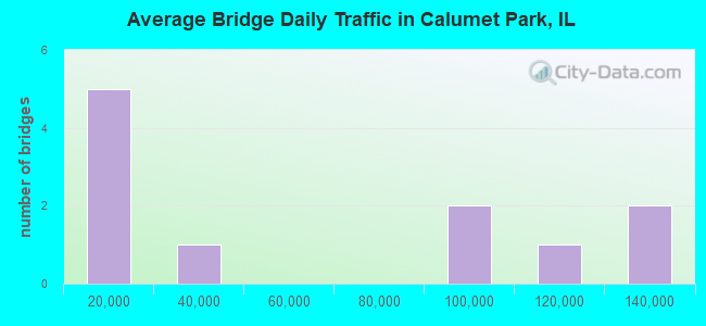
- 636,750Total average daily traffic
- 35,962Total average daily truck traffic
- National Bridge Inventory (NBI) Registered Bridges for Calumet Park
- No street view available for this location
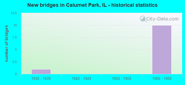
- New bridges - historical statistics
- 11930-1939
- 101960-1969
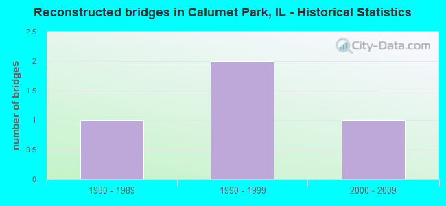
- Reconstructed bridges - Historical Statistics
- 11980-1989
- 21990-1999
- 12000-2009
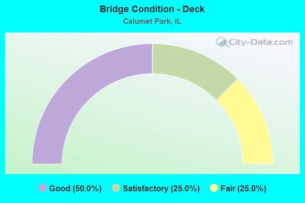
- Bridge Condition - Deck
- 50.0%Good
- 25.0%Satisfactory
- 25.0%Fair
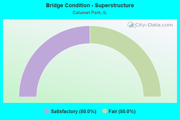
- Bridge Condition - Superstructure
- 50.0%Satisfactory
- 50.0%Fair
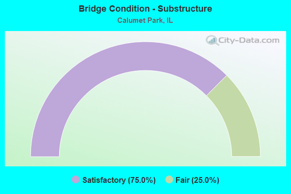
- Bridge Condition - Substructure
- 75.0%Satisfactory
- 25.0%Fair
Find on map >> Show street view
Structure Number: 160294, Location: 1 M S 127TH ST (Lat: 41.655397, Lng: -87.660619), Route carried "on" structure: Other road , Year Built: 1933, Year Reconstructed: 1998, Status: Open, Structure Length: 11.53m (37.83ft), Average Daily Traffic: 18,900 (year 2021), Truck Traffic: 4%, Average Future Daily Traffic: 16,068 (year 2032), Design Load: HS 20, Features Intersected: CAL SAG CHANNEL, Facility Carried by Structure: ASHLAND AVE
Minimum Vertical Clearance: 4.50m (14.76ft), Kilometerpoint: 2.269, Lanes on structure: 4, Base Highway Network: Yes, Owner: State Highway Agency, Approaching Roadway Width: 12.2m (40.0ft), Navigation Control: Yes ( Vertical Clearance: 7.9m (25.9ft), Horizontal Clearance: 68.6m (225.1ft)), Material/Design: Steel, Design/Construction: Truss - Thru, Number Of Spans In Main Unit: 1, Number Of Approach Spans: 2, Length of Maximum Span: 76.2m (250.0ft), Curb or Sidewalk Widths: Left: 1.7m (5.6ft), Right: 1.7m (5.6ft), Curb-To-Curb Width: 13.4m (44.0ft), Out-to-Out Width: 19.3m (63.3ft)
Condition: Deck: Good, Superstructure: Fair, Substructure: Satisfactory, Channel: Very good, Operating Rating: 58.3 metric tons, Method Used To Determine Operating Rating: Load Factor (LF) rating reported by rating factor (RF) method using MS18 loading, Inventory Rating: 34.7 metric tons, Method Used To Determine Inventory Rating: Load Factor (LF) rating reported by rating factor (RF) method using MS18 loading, Structural Evaluation: Somewhat better than minimum adequacy, Deck Geometry: High priority of replacement, Waterway Adequacy: Equal to present desirable criteria, Approach Roadway Alignment: Equal to present desirable criteria, Length Of Structure Improvement: 11.77m (38.62ft), Designated Inspection Frequency: Every 24 months, Critical Feature Inspection Frequency: Every 24 months, Underwater Inspection Frequency: Every 60 months, Inspection Date: May 2021, Critical Feature Inspection Date: May 2021, Underwater Inspection Date: July 2020, Bridge Improvement Cost: $1,533,000, Roadway Improvement Cost: $153,000, Total Project Cost: $2,529,000, Deck Structure Type: Concrete Cast-file-Place, Wearing Surface/Protective System: Wearing Surface: Epoxy Overlay
Find on map >> Show street view
Structure Number: 160904, Location: 3.1 M SW IL 1 (Lat: 41.677531, Lng: -87.661739), Route carried "on" structure: Other road , Year Built: 1965, Year Reconstructed: 2004, Status: Open, Structure Length: 5.17m (16.96ft), Average Daily Traffic: 19,900 (year 2021), Truck Traffic: 3%, Average Future Daily Traffic: 21,733 (year 2032), Design Load: HS 20, Features Intersected: I- 57, Facility Carried by Structure: 119TH ST
Minimum Vertical Clearance: 30+ m (98+ ft), Kilometerpoint: 5.633, Lanes on structure: 5, Lanes under structure: 6, Base Highway Network: Yes, Owner: State Highway Agency, Approaching Roadway Width: 13.4m (44.0ft), Material/Design: Steel continuous, Design/Construction: Stringer/Multi-beam, Number Of Spans In Main Unit: 2, Length of Maximum Span: 25.3m (83.0ft), Curb or Sidewalk Widths: Left: 2.3m (7.5ft), Right: 2.3m (7.5ft), Curb-To-Curb Width: 20.0m (65.6ft), Out-to-Out Width: 25.3m (83.0ft)
Condition: Deck: Good, Superstructure: Satisfactory, Substructure: Satisfactory, Operating Rating: 65.1 metric tons, Method Used To Determine Operating Rating: Load Factor (LF) rating reported by rating factor (RF) method using MS18 loading, Inventory Rating: 39.2 metric tons, Method Used To Determine Inventory Rating: Load Factor (LF) rating reported by rating factor (RF) method using MS18 loading, Structural Evaluation: Equal to present minimum criteria, Deck Geometry: Somewhat better than minimum adequacy, Underclear: Meets minimum limits, Approach Roadway Alignment: Equal to present desirable criteria, Designated Inspection Frequency: Every 24 months, Inspection Date: November 2021, Deck Structure Type: Concrete Cast-file-Place, Wearing Surface/Protective System: Deck Protection: Epoxy Coated Reinforcing
Find on map >> Show street view
Structure Number: 160909, Location: 4.1 M SW IL 1 (Lat: 41.662844, Lng: -87.663281), Route carried "on" structure: Other road , Year Built: 1966, Year Reconstructed: 1994, Status: Open, Structure Length: 6.68m (21.92ft), Average Daily Traffic: 28,500 (year 2021), Truck Traffic: 4%, Average Future Daily Traffic: 18,540 (year 2032), Design Load: HS 20, Features Intersected: I- 57, Facility Carried by Structure: 127TH ST
Minimum Vertical Clearance: 30+ m (98+ ft), Kilometerpoint: 25.202, Lanes on structure: 7, Lanes under structure: 6, Base Highway Network: Yes, Owner: State Highway Agency, Approaching Roadway Width: 27.4m (89.9ft), Material/Design: Steel continuous, Design/Construction: Stringer/Multi-beam, Number Of Spans In Main Unit: 2, Number Of Approach Spans: 2, Length of Maximum Span: 25.0m (82.0ft), Curb or Sidewalk Widths: Left: 1.7m (5.6ft), Right: 1.7m (5.6ft), Curb-To-Curb Width: 27.4m (89.9ft), Out-to-Out Width: 31.4m (103.0ft)
Condition: Deck: Fair, Superstructure: Fair, Substructure: Fair, Operating Rating: 59.6 metric tons, Method Used To Determine Operating Rating: Load Factor (LF) rating reported by rating factor (RF) method using MS18 loading, Inventory Rating: 36.0 metric tons, Method Used To Determine Inventory Rating: Load Factor (LF) rating reported by rating factor (RF) method using MS18 loading, Structural Evaluation: Somewhat better than minimum adequacy, Deck Geometry: Somewhat better than minimum adequacy, Underclear: Meets minimum limits, Approach Roadway Alignment: Equal to present desirable criteria, Designated Inspection Frequency: Every 24 months, Inspection Date: March 2020, Deck Structure Type: Concrete Cast-file-Place, Wearing Surface/Protective System: Deck Protection: Epoxy Coated Reinforcing
Find on map >> Show street view
Structure Number: 162034, Location: 3.8 M SW IL 1 (Lat: 41.666281, Lng: -87.664075), Route carried "on" structure: City street , Year Built: 1966, Year Reconstructed: 2009, Status: Open, Structure Length: 6.32m (20.73ft), Average Daily Traffic: 1,050 (year 2018), Truck Traffic: 15%, Average Future Daily Traffic: 5,159 (year 2032), Design Load: HS 20, Features Intersected: I- 57, Facility Carried by Structure: 125TH ST
Minimum Vertical Clearance: 30+ m (98+ ft), Kilometerpoint: 0.080, Lanes on structure: 2, Lanes under structure: 8, Owner: State Highway Agency, Approaching Roadway Width: 7.9m (25.9ft), Material/Design: Steel continuous, Design/Construction: Stringer/Multi-beam, Number Of Spans In Main Unit: 2, Length of Maximum Span: 33.3m (109.3ft), Curb or Sidewalk Widths: Left: 1.7m (5.6ft), Right: 1.7m (5.6ft), Curb-To-Curb Width: 7.9m (25.9ft), Out-to-Out Width: 12.5m (41.0ft)
Condition: Deck: Satisfactory, Superstructure: Satisfactory, Substructure: Satisfactory, Operating Rating: 69.7 metric tons, Method Used To Determine Operating Rating: Load Factor (LF) rating reported by rating factor (RF) method using MS18 loading, Inventory Rating: 41.8 metric tons, Method Used To Determine Inventory Rating: Load Factor (LF) rating reported by rating factor (RF) method using MS18 loading, Structural Evaluation: Equal to present minimum criteria, Deck Geometry: Meets minimum limits, Underclear: High priority of replacement, Approach Roadway Alignment: Equal to present desirable criteria, Length Of Structure Improvement: 7.71m (25.30ft), Designated Inspection Frequency: Every 24 months, Inspection Date: Febuary 2022, Bridge Improvement Cost: $1,300,000, Roadway Improvement Cost: $130,000, Total Project Cost: $1,950,000, Deck Structure Type: Concrete Cast-file-Place, Wearing Surface/Protective System: Deck Protection: Epoxy Coated Reinforcing
Find on map >> Show street view
Structure Number: 160066, Location: 2.5 NE ILL 83 (Lat: 41.658169, Lng: -87.662100), Route carried "under" structure: Other road , Year Built: 1966, Structure Length: 0. m, Average Daily Traffic: 13,200 (year 2021), Truck Traffic: 3%, Features Intersected: VERMONT ST, Facility Carried by Structure: I- 57 SB
Minimum Vertical Clearance: 4.70m (15.42ft), Kilometerpoint: 2.511, Lanes on structure: 4, Lanes under structure: 4, Material/Design: Steel continuous, Design/Construction: Stringer/Multi-beam, Length of Maximum Span: 21.3m (69.9ft)
Find on map >> Show street view
Structure Number: 160067, Location: 2.5 NE ILL 83 (Lat: 41.658089, Lng: -87.662361), Route carried "under" structure: Other road , Year Built: 1966, Structure Length: 0. m, Average Daily Traffic: 13,200 (year 2021), Truck Traffic: 3%, Features Intersected: VERMONT ST, Facility Carried by Structure: I- 57 NB
Minimum Vertical Clearance: 4.57m (14.99ft), Kilometerpoint: 2.478, Lanes on structure: 3, Lanes under structure: 4, Material/Design: Steel continuous, Design/Construction: Stringer/Multi-beam, Length of Maximum Span: 21.3m (69.9ft)
Find on map >> Show street view
Structure Number: 160068, Location: 3.7 M SW ILL 1 (Lat: 41.668181, Lng: -87.662472), Route carried "under" structure: Interstate 57, Year Built: 1966, Structure Length: 0. m, Average Daily Traffic: 120,800 (year 2021), Truck Traffic: 6%, Features Intersected: I- 57, Facility Carried by Structure: RR - METRA
Minimum Vertical Clearance: 4.88m (16.01ft), Kilometerpoint: 569.000, Lanes under structure: 6, Material/Design: Steel, Design/Construction: Girder and Floorbeam System, Length of Maximum Span: 42.7m (140.1ft)
Find on map >> Show street view
Structure Number: 160904, Location: 3.1 M SW IL 1 (Lat: 41.677531, Lng: -87.661739), Route carried "under" structure: Interstate 57, Year Built: 1965, Structure Length: 0. m, Average Daily Traffic: 113,200 (year 2021), Truck Traffic: 6%, Features Intersected: I- 57, Facility Carried by Structure: 119TH ST
Minimum Vertical Clearance: 4.70m (15.42ft), Kilometerpoint: 570.078, Lanes on structure: 5, Lanes under structure: 6, Material/Design: Steel continuous, Design/Construction: Stringer/Multi-beam, Length of Maximum Span: 25.3m (83.0ft)
Find on map >> Show street view
Structure Number: 160909, Location: 4.1 M SW IL 1 (Lat: 41.662850, Lng: -87.662581), Route carried "under" structure: Interstate 57, Year Built: 1966, Structure Length: 0. m, Average Daily Traffic: 93,600 (year 2021), Truck Traffic: 6%, Features Intersected: I- 57, Facility Carried by Structure: 127TH ST
Minimum Vertical Clearance: 4.57m (14.99ft), Kilometerpoint: 568.437, Lanes on structure: 7, Lanes under structure: 6, Material/Design: Steel continuous, Design/Construction: Stringer/Multi-beam, Length of Maximum Span: 25.0m (82.0ft)
Find on map >> Show street view
Structure Number: 162033, Location: 3.6 M SW IL 1 (Lat: 41.670308, Lng: -87.662189), Route carried "under" structure: Interstate 57, Year Built: 1966, Structure Length: 0. m, Average Daily Traffic: 120,800 (year 2021), Truck Traffic: 6%, Features Intersected: I- 57, Facility Carried by Structure: 123RD ST
Minimum Vertical Clearance: 4.65m (15.26ft), Kilometerpoint: 569.306, Lanes on structure: 2, Lanes under structure: 6, Material/Design: Steel continuous, Design/Construction: Stringer/Multi-beam, Length of Maximum Span: 21.6m (70.9ft)
Find on map >> Show street view
Structure Number: 162034, Location: 3.8 M SW IL 1 (Lat: 41.666567, Lng: -87.662631), Route carried "under" structure: Interstate 57, Year Built: 1966, Structure Length: 0. m, Average Daily Traffic: 93,600 (year 2021), Truck Traffic: 6%, Features Intersected: I- 57, Facility Carried by Structure: 125TH ST
Minimum Vertical Clearance: 4.78m (15.68ft), Kilometerpoint: 568.855, Lanes on structure: 2, Lanes under structure: 8, Material/Design: Steel continuous, Design/Construction: Stringer/Multi-beam, Length of Maximum Span: 33.3m (109.3ft)