Bridge Statistics for Campbell, Minnesota (MN)
Condition, Traffic, Stress, Structural Evaluation, Project Costs
- National Bridge Inventory (NBI) Statistics
- 18Number of bridges
- 82ft / 24.5mTotal length
- $802,000,000Total costs
- 1,649Total average daily traffic
- 139Total average daily truck traffic
- 1,603Total future (year 2029) average daily traffic
- National Bridge Inventory (NBI) Registered Bridges for Campbell
- No street view available for this location
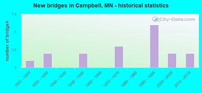
- New bridges - historical statistics
- 11920-1929
- 21930-1939
- 21950-1959
- 31970-1979
- 61990-1999
- 22000-2009
- 22010-2019
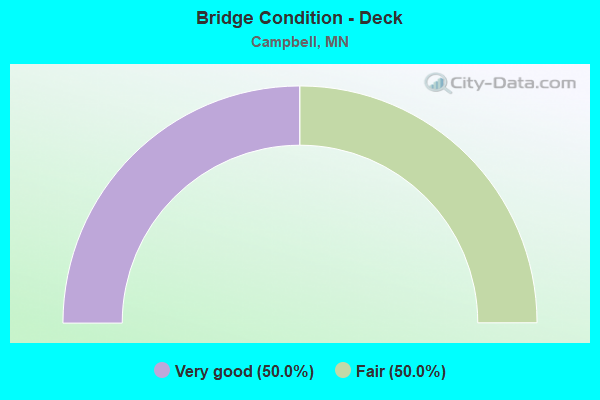
- Bridge Condition - Deck
- 50.0%Very good
- 50.0%Fair
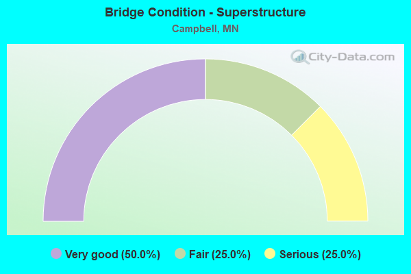
- Bridge Condition - Superstructure
- 50.0%Very good
- 25.0%Fair
- 25.0%Serious
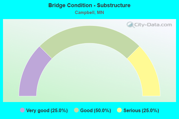
- Bridge Condition - Substructure
- 25.0%Very good
- 50.0%Good
- 25.0%Serious
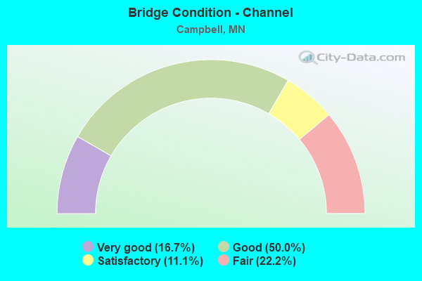
- Bridge Condition - Channel
- 16.7%Very good
- 50.0%Good
- 11.1%Satisfactory
- 22.2%Fair
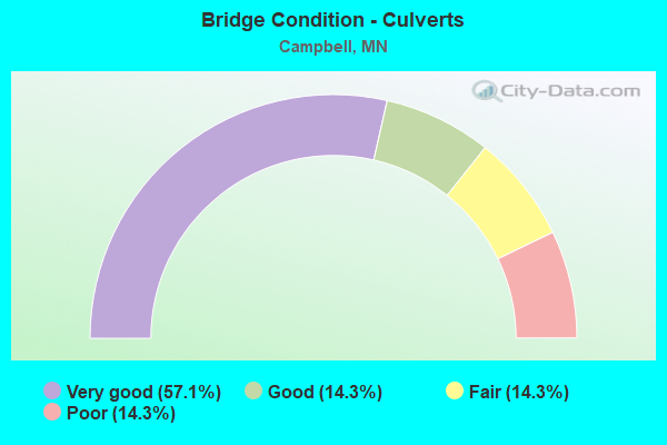
- Bridge Condition - Culverts
- 57.1%Very good
- 14.3%Good
- 14.3%Fair
- 14.3%Poor
Find on map >> Show street view
Structure Number: 7145, Location: 0.5 MI S OF JCT TH 9 (Lat: 46.095256, Lng: -96.410544), Route carried "on" structure: County highway 4, Year Built: 1955, Status: Posted for load, Structure Length: 4.31m (14.14ft), Average Daily Traffic: 235 (year 2014), Average Future Daily Traffic: 235 (year 2039), Features Intersected: RABBIT RIVER
Minimum Vertical Clearance: 30+ m (98+ ft), Kilometerpoint: 0.000, Lanes on structure: 2, Owner: County Highway Agency, Approaching Roadway Width: 9.1m (29.9ft), Material/Design: Steel continuous, Design/Construction: Stringer/Multi-beam, Number Of Spans In Main Unit: 3, Length of Maximum Span: 18.3m (60.0ft), Curb-To-Curb Width: 7.3m (24.0ft), Out-to-Out Width: 8.1m (26.6ft)
Condition: Deck: Fair, Superstructure: Fair, Substructure: Good, Channel: Satisfactory, Operating Rating: 27.3 metric tons, Method Used To Determine Operating Rating: Load Factor (LF), Inventory Rating: 16.3 metric tons, Method Used To Determine Inventory Rating: Load Factor (LF), Structural Evaluation: Somewhat better than minimum adequacy, Deck Geometry: Somewhat better than minimum adequacy, Waterway Adequacy: Equal to present desirable criteria, Approach Roadway Alignment: Equal to present desirable criteria, Bridge Posting: Required (Relationship of Operating Rating to Maximum Legal Load: 20.0 - 29.9% below), Length Of Structure Improvement: 1.59m (5.22ft), Designated Inspection Frequency: Every 24 months, Other Special Inspection Frequency: Every 60 months, Inspection Date: September 2021, Other Special Inspection Date: October 2020, Bridge Improvement Cost: $501,000,000, Roadway Improvement Cost: $25,000,000, Total Project Cost: $381,000,000, Deck Structure Type: Concrete Cast-file-Place, Wearing Surface/Protective System: Wearing Surface: Monolithic Concrete
Find on map >> Show street view
Structure Number: 84003, Location: 1.0 MI SE OF CAMPBELL (Lat: 46.086631, Lng: -96.390939), Route carried "on" structure: State highway 9, Year Built: 1991, Status: Open, Structure Length: 2.74m (8.99ft), Average Daily Traffic: 520 (year 2019), Truck Traffic: 13%, Average Future Daily Traffic: 445 (year 2039), Design Load: HS 25 or greater, Features Intersected: RABBIT RIVER
Minimum Vertical Clearance: 30+ m (98+ ft), Kilometerpoint: 0.000, Lanes on structure: 2, Base Highway Network: Yes, Owner: State Highway Agency, Approaching Roadway Width: 11.0m (36.1ft), Material/Design: Prestressed concrete, Design/Construction: Stringer/Multi-beam, Number Of Spans In Main Unit: 1, Length of Maximum Span: 26.0m (85.3ft), Curb-To-Curb Width: 10.6m (34.8ft), Out-to-Out Width: 11.6m (38.1ft)
Condition: Deck: Very good, Superstructure: Very good, Substructure: Good, Channel: Very good, Operating Rating: 86.9 metric tons, Method Used To Determine Operating Rating: Load Factor (LF), Inventory Rating: 42.1 metric tons, Method Used To Determine Inventory Rating: Load Factor (LF), Structural Evaluation: Better than present minimum criteria, Deck Geometry: Equal to present minimum criteria, Waterway Adequacy: Equal to present desirable criteria, Approach Roadway Alignment: Equal to present desirable criteria, Designated Inspection Frequency: Every 24 months, Inspection Date: August 2020, Deck Structure Type: Concrete Cast-file-Place, Wearing Surface/Protective System: Wearing Surface: Monolithic Concrete, Deck Protection: Epoxy Coated Reinforcing
Find on map >> Show street view
Structure Number: 84525, Location: 0.7 MI W OF JCT TH 9 (Lat: 46.065094, Lng: -96.384047), Route carried "on" structure: County highway 152, Year Built: 1999, Status: Open, Structure Length: 2.44m (8.01ft), Average Daily Traffic: 30 (year 2010), Average Future Daily Traffic: 30 (year 2039), Design Load: HS 25 or greater, Features Intersected: S FK RABBIT RIVER
Minimum Vertical Clearance: 30+ m (98+ ft), Kilometerpoint: 0.000, Lanes on structure: 2, Owner: County Highway Agency, Approaching Roadway Width: 8.5m (27.9ft), Skew: 3 degrees, Material/Design: Prestressed concrete, Design/Construction: Stringer/Multi-beam, Number Of Spans In Main Unit: 1, Length of Maximum Span: 21.2m (69.6ft), Curb-To-Curb Width: 9.8m (32.2ft), Out-to-Out Width: 10.7m (35.1ft)
Condition: Deck: Very good, Superstructure: Very good, Substructure: Very good, Channel: Good, Operating Rating: 76.7 metric tons, Method Used To Determine Operating Rating: Load Factor (LF), Inventory Rating: 46.0 metric tons, Method Used To Determine Inventory Rating: Load Factor (LF), Structural Evaluation: Equal to present desirable criteria, Deck Geometry: Equal to present desirable criteria, Waterway Adequacy: Superior to present desirable criteria, Approach Roadway Alignment: Equal to present desirable criteria, Designated Inspection Frequency: Every 24 months, Inspection Date: November 2020, Deck Structure Type: Concrete Cast-file-Place, Wearing Surface/Protective System: Wearing Surface: Monolithic Concrete, Deck Protection: Epoxy Coated Reinforcing
Find on map >> Show street view
Structure Number: 84J38, Location: 1.3 MI W OF JCT TH 9 (Lat: 46.050564, Lng: -96.384108), Route carried "on" structure: County highway 120, Year Built: 2000, Status: Open, Structure Length: 1.14m (3.74ft), Average Daily Traffic: 10 (year 1999), Average Future Daily Traffic: 10 (year 2029), Design Load: HS 20, Features Intersected: S Fk Rabbit River
Minimum Vertical Clearance: 30+ m (98+ ft), Kilometerpoint: 0.000, Lanes on structure: 2, Owner: County Highway Agency, Approaching Roadway Width: 7.3m (24.0ft), Skew: 3 degrees, Material/Design: Concrete, Design/Construction: Culvert, Number Of Spans In Main Unit: 2, Length of Maximum Span: 4.1m (13.5ft)
Condition: Channel: Fair, Culverts: Very good, Operating Rating: 53.9 metric tons, Method Used To Determine Operating Rating: Assigned ratings based on Allowable Stress Design (ASD) reported in metric tons, Inventory Rating: 35.9 metric tons, Method Used To Determine Inventory Rating: Assigned ratings based on Allowable Stress Design (ASD) reported in metric tons, Structural Evaluation: Equal to present desirable criteria, Waterway Adequacy: Better than present minimum criteria, Approach Roadway Alignment: Better than present minimum criteria, Designated Inspection Frequency: Every 48 months, Inspection Date: October 2021
Find on map >> Show street view
Structure Number: 84J44, Location: 1.1 MI N OF JCT TH 55 (Lat: 46.052339, Lng: -96.389428), Route carried "on" structure: County highway 151, Year Built: 2000, Status: Open, Structure Length: 1.14m (3.74ft), Average Daily Traffic: 18 (year 1999), Average Future Daily Traffic: 18 (year 2029), Design Load: HS 20, Features Intersected: S Fk Rabbit River
Minimum Vertical Clearance: 30+ m (98+ ft), Kilometerpoint: 0.000, Lanes on structure: 2, Owner: County Highway Agency, Approaching Roadway Width: 7.3m (24.0ft), Skew: 3 degrees, Material/Design: Concrete, Design/Construction: Culvert, Number Of Spans In Main Unit: 2, Length of Maximum Span: 4.0m (13.1ft)
Condition: Channel: Good, Culverts: Very good, Operating Rating: 53.9 metric tons, Method Used To Determine Operating Rating: Assigned ratings based on Allowable Stress Design (ASD) reported in metric tons, Inventory Rating: 35.9 metric tons, Method Used To Determine Inventory Rating: Assigned ratings based on Allowable Stress Design (ASD) reported in metric tons, Structural Evaluation: Equal to present desirable criteria, Waterway Adequacy: Better than present minimum criteria, Approach Roadway Alignment: Better than present minimum criteria, Designated Inspection Frequency: Every 48 months, Inspection Date: October 2021
Find on map >> Show street view
Structure Number: 84J72, Location: 0.1 MI N OF JCT TH 9 (Lat: 46.085006, Lng: -96.389192), Route carried "on" structure: County highway 95, Year Built: 2018, Status: Open, Structure Length: 0.66m (2.17ft), Average Daily Traffic: 17 (year 2017), Average Future Daily Traffic: 17 (year 2037), Design Load: HL 93, Features Intersected: CD #12
Minimum Vertical Clearance: 30+ m (98+ ft), Kilometerpoint: 0.000, Lanes on structure: 2, Owner: County Highway Agency, Approaching Roadway Width: 8.5m (27.9ft), Material/Design: Concrete, Design/Construction: Culvert, Number Of Spans In Main Unit: 2, Length of Maximum Span: 3.0m (9.8ft)
Condition: Channel: Good, Culverts: Very good, Operating Rating: 42.1 metric tons, Method Used To Determine Operating Rating: Assigned ratings based on Load and Resistance Factor Design (LRFD) reported by rating factor (RF) using HL93 loadings, Inventory Rating: 32.4 metric tons, Method Used To Determine Inventory Rating: Assigned ratings based on Load and Resistance Factor Design (LRFD) reported by rating factor (RF) using HL93 loadings, Structural Evaluation: Equal to present desirable criteria, Waterway Adequacy: Superior to present desirable criteria, Approach Roadway Alignment: Equal to present desirable criteria, Designated Inspection Frequency: Every 48 months, Inspection Date: September 2019
Find on map >> Show street view
Structure Number: 84J73, Location: 1.0 MI N OF JCT CSAH 4 (Lat: 46.107956, Lng: -96.471925), Route carried "on" structure: County highway 140, Year Built: 2018, Status: Open, Structure Length: 0.90m (2.95ft), Average Daily Traffic: 17 (year 2017), Average Future Daily Traffic: 17 (year 2037), Design Load: HL 93, Features Intersected: RABBIT RIVER
Minimum Vertical Clearance: 30+ m (98+ ft), Kilometerpoint: 0.000, Lanes on structure: 2, Owner: County Highway Agency, Approaching Roadway Width: 8.5m (27.9ft), Material/Design: Concrete, Design/Construction: Culvert, Number Of Spans In Main Unit: 2, Length of Maximum Span: 4.3m (14.1ft)
Condition: Channel: Good, Culverts: Very good, Operating Rating: 42.1 metric tons, Method Used To Determine Operating Rating: Assigned ratings based on Load and Resistance Factor Design (LRFD) reported by rating factor (RF) using HL93 loadings, Inventory Rating: 32.4 metric tons, Method Used To Determine Inventory Rating: Assigned ratings based on Load and Resistance Factor Design (LRFD) reported by rating factor (RF) using HL93 loadings, Structural Evaluation: Equal to present desirable criteria, Waterway Adequacy: Superior to present desirable criteria, Approach Roadway Alignment: Equal to present desirable criteria, Designated Inspection Frequency: Every 48 months, Inspection Date: September 2019
Find on map >> Show street view
Structure Number: 8934, Location: 0.1 MI E OF JCT TH9 (Lat: 46.079583, Lng: -96.384369), Route carried "on" structure: County highway 2, Year Built: 1950, Status: Open, Structure Length: 0.80m (2.62ft), Average Daily Traffic: 25 (year 2010), Average Future Daily Traffic: 25 (year 2039), Features Intersected: JUD DITCH # 12
Minimum Vertical Clearance: 30+ m (98+ ft), Kilometerpoint: 0.000, Lanes on structure: 2, Owner: County Highway Agency, Approaching Roadway Width: 8.5m (27.9ft), Skew: 3 degrees, Material/Design: Concrete, Design/Construction: Culvert, Number Of Spans In Main Unit: 2, Length of Maximum Span: 4.4m (14.4ft)
Condition: Channel: Good, Culverts: Poor, Operating Rating: 53.9 metric tons, Method Used To Determine Operating Rating: Assigned ratings based on Allowable Stress Design (ASD) reported in metric tons, Inventory Rating: 35.9 metric tons, Method Used To Determine Inventory Rating: Assigned ratings based on Allowable Stress Design (ASD) reported in metric tons, Structural Evaluation: Meets minimum limits, Waterway Adequacy: Better than present minimum criteria, Approach Roadway Alignment: Better than present minimum criteria, Length Of Structure Improvement: 0.40m (1.31ft), Designated Inspection Frequency: Every 12 months, Inspection Date: September 2021, Bridge Improvement Cost: $59,000,000, Roadway Improvement Cost: $3,000,000, Total Project Cost: $46,000,000
Find on map >> Show street view
Structure Number: 9003, Location: 0.1 MI E OF JCT TH9 (Lat: 46.065078, Lng: -96.371406), Route carried "on" structure: County highway 6, Year Built: 1936, Status: Open, Structure Length: 0.93m (3.05ft), Average Daily Traffic: 5 (year 2010), Average Future Daily Traffic: 5 (year 2039), Features Intersected: JUD DITCH # 12
Minimum Vertical Clearance: 30+ m (98+ ft), Kilometerpoint: 0.000, Lanes on structure: 2, Owner: County Highway Agency, Approaching Roadway Width: 6.7m (22.0ft), Skew: 3 degrees, Material/Design: Concrete, Design/Construction: Culvert, Number Of Spans In Main Unit: 2, Length of Maximum Span: 4.4m (14.4ft)
Condition: Channel: Fair, Culverts: Poor, Operating Rating: 53.9 metric tons, Method Used To Determine Operating Rating: Assigned ratings based on Allowable Stress Design (ASD) reported in metric tons, Inventory Rating: 35.9 metric tons, Method Used To Determine Inventory Rating: Assigned ratings based on Allowable Stress Design (ASD) reported in metric tons, Structural Evaluation: Meets minimum limits, Waterway Adequacy: Better than present minimum criteria, Approach Roadway Alignment: Better than present minimum criteria, Designated Inspection Frequency: Every 24 months, Inspection Date: September 2021
Find on map >> Show street view
Structure Number: 91617, Location: 0.1 MI S OF JCT CR 156 (Lat: 46.151858, Lng: -96.369050), Route carried "on" structure: County highway 169, Year Built: 1978, Status: Open, Structure Length: 0.76m (2.49ft), Average Daily Traffic: 40 (year 2010), Average Future Daily Traffic: 40 (year 2039), Design Load: HS 20, Features Intersected: CO DITCH # 8
Minimum Vertical Clearance: 30+ m (98+ ft), Kilometerpoint: 0.000, Lanes on structure: 2, Owner: County Highway Agency, Approaching Roadway Width: 8.5m (27.9ft), Material/Design: Concrete, Design/Construction: Culvert, Number Of Spans In Main Unit: 2, Length of Maximum Span: 3.1m (10.2ft)
Condition: Channel: Very good, Culverts: Good, Operating Rating: 53.9 metric tons, Method Used To Determine Operating Rating: Assigned ratings based on Allowable Stress Design (ASD) reported in metric tons, Inventory Rating: 35.9 metric tons, Method Used To Determine Inventory Rating: Assigned ratings based on Allowable Stress Design (ASD) reported in metric tons, Structural Evaluation: Better than present minimum criteria, Waterway Adequacy: Better than present minimum criteria, Approach Roadway Alignment: Equal to present desirable criteria, Designated Inspection Frequency: Every 48 months, Inspection Date: September 2019
Find on map >> Show street view
Structure Number: 91647, Location: 1.8 MI N OF JCT CSAH 4 (Lat: 46.133861, Lng: -96.388589), Route carried "on" structure: County highway 95, Year Built: 1978, Status: Open, Structure Length: 1.16m (3.81ft), Average Daily Traffic: 20 (year 1986), Average Future Daily Traffic: 20 (year 2029), Design Load: HS 20, Features Intersected: CO DITCH # 8A
Minimum Vertical Clearance: 30+ m (98+ ft), Kilometerpoint: 0.000, Lanes on structure: 2, Owner: County Highway Agency, Approaching Roadway Width: 7.3m (24.0ft), Skew: 4 degrees, Material/Design: Concrete, Design/Construction: Culvert, Number Of Spans In Main Unit: 2, Length of Maximum Span: 3.1m (10.2ft)
Condition: Channel: Satisfactory, Culverts: Very good, Operating Rating: 53.9 metric tons, Method Used To Determine Operating Rating: Assigned ratings based on Allowable Stress Design (ASD) reported in metric tons, Inventory Rating: 35.9 metric tons, Method Used To Determine Inventory Rating: Assigned ratings based on Allowable Stress Design (ASD) reported in metric tons, Structural Evaluation: Equal to present desirable criteria, Waterway Adequacy: Better than present minimum criteria, Approach Roadway Alignment: Equal to present desirable criteria, Designated Inspection Frequency: Every 48 months, Inspection Date: September 2019
Find on map >> Show street view
Structure Number: 91648, Location: 0.9 MI W OF JCT CR 169 (Lat: 46.137408, Lng: -96.388450), Route carried "on" structure: County highway 107, Year Built: 1978, Status: Open, Structure Length: 0.89m (2.92ft), Average Daily Traffic: 20 (year 1986), Average Future Daily Traffic: 20 (year 2029), Design Load: HS 20, Features Intersected: CO DITCH # 8A
Minimum Vertical Clearance: 30+ m (98+ ft), Kilometerpoint: 0.000, Lanes on structure: 2, Owner: County Highway Agency, Approaching Roadway Width: 7.3m (24.0ft), Material/Design: Concrete, Design/Construction: Culvert, Number Of Spans In Main Unit: 2, Length of Maximum Span: 3.5m (11.5ft)
Condition: Channel: Very good, Culverts: Good, Operating Rating: 53.9 metric tons, Method Used To Determine Operating Rating: Assigned ratings based on Allowable Stress Design (ASD) reported in metric tons, Inventory Rating: 35.9 metric tons, Method Used To Determine Inventory Rating: Assigned ratings based on Allowable Stress Design (ASD) reported in metric tons, Structural Evaluation: Better than present minimum criteria, Waterway Adequacy: Better than present minimum criteria, Approach Roadway Alignment: Equal to present desirable criteria, Designated Inspection Frequency: Every 48 months, Inspection Date: September 2019
Find on map >> Show street view
Structure Number: 96722, Location: 1.3 MI NW OF CAMPBELL (Lat: 46.114803, Lng: -96.416114), Route carried "on" structure: State highway 9, Year Built: 1991, Status: Open, Structure Length: 1.40m (4.59ft), Average Daily Traffic: 601 (year 2019), Truck Traffic: 12%, Average Future Daily Traffic: 630 (year 2039), Design Load: HS 25 or greater, Features Intersected: STREAM
Minimum Vertical Clearance: 30+ m (98+ ft), Kilometerpoint: 0.000, Lanes on structure: 2, Base Highway Network: Yes, Owner: State Highway Agency, Approaching Roadway Width: 11.0m (36.1ft), Material/Design: Concrete, Design/Construction: Culvert, Number Of Spans In Main Unit: 3, Length of Maximum Span: 3.7m (12.1ft)
Condition: Channel: Fair, Culverts: Fair, Operating Rating: 58.8 metric tons, Method Used To Determine Operating Rating: Assigned rating based on Load Factor Design (LFD) reported in metric tons, Inventory Rating: 39.2 metric tons, Method Used To Determine Inventory Rating: Assigned rating based on Load Factor Design (LFD) reported in metric tons, Structural Evaluation: Somewhat better than minimum adequacy, Waterway Adequacy: Better than present minimum criteria, Approach Roadway Alignment: Equal to present desirable criteria, Designated Inspection Frequency: Every 24 months, Inspection Date: August 2020
Find on map >> Show street view
Structure Number: 97151, Location: 0.6 MI N OF JCT TH 9 (Lat: 46.116103, Lng: -96.409478), Route carried "on" structure: County highway 17, Year Built: 1995, Status: Open, Structure Length: 1.41m (4.63ft), Average Daily Traffic: 40 (year 2010), Average Future Daily Traffic: 40 (year 2039), Design Load: HS 25 or greater, Features Intersected: STREAM
Minimum Vertical Clearance: 30+ m (98+ ft), Kilometerpoint: 0.000, Lanes on structure: 2, Owner: County Highway Agency, Approaching Roadway Width: 8.5m (27.9ft), Skew: 3 degrees, Material/Design: Concrete, Design/Construction: Culvert, Number Of Spans In Main Unit: 3, Length of Maximum Span: 3.5m (11.5ft)
Condition: Channel: Good, Culverts: Very good, Operating Rating: 58.8 metric tons, Method Used To Determine Operating Rating: Assigned rating based on Load Factor Design (LFD) reported in metric tons, Inventory Rating: 39.2 metric tons, Method Used To Determine Inventory Rating: Assigned rating based on Load Factor Design (LFD) reported in metric tons, Structural Evaluation: Equal to present desirable criteria, Waterway Adequacy: Superior to present desirable criteria, Approach Roadway Alignment: Equal to present desirable criteria, Designated Inspection Frequency: Every 48 months, Inspection Date: September 2019
Find on map >> Show street view
Structure Number: 97512, Location: 0.6 MI W OF JCT TH 9 (Lat: 46.079753, Lng: -96.394614), Route carried "on" structure: County highway 116, Year Built: 1993, Status: Open, Structure Length: 1.03m (3.38ft), Average Daily Traffic: 6 (year 1993), Average Future Daily Traffic: 6 (year 2029), Design Load: HS 20, Features Intersected: S FK RABBIT RIVER
Minimum Vertical Clearance: 30+ m (98+ ft), Kilometerpoint: 0.000, Lanes on structure: 2, Owner: County Highway Agency, Approaching Roadway Width: 7.3m (24.0ft), Skew: 1 degrees, Material/Design: Concrete, Design/Construction: Culvert, Number Of Spans In Main Unit: 2, Length of Maximum Span: 3.6m (11.8ft)
Condition: Channel: Good, Culverts: Very good, Operating Rating: 53.9 metric tons, Method Used To Determine Operating Rating: Assigned ratings based on Allowable Stress Design (ASD) reported in metric tons, Inventory Rating: 35.9 metric tons, Method Used To Determine Inventory Rating: Assigned ratings based on Allowable Stress Design (ASD) reported in metric tons, Structural Evaluation: Equal to present desirable criteria, Waterway Adequacy: Superior to present desirable criteria, Approach Roadway Alignment: Equal to present desirable criteria, Designated Inspection Frequency: Every 48 months, Inspection Date: September 2019
Find on map >> Show street view
Structure Number: 97997, Location: 0.5 MI S OF JCT CR 152 (Lat: 46.057883, Lng: -96.389289), Route carried "on" structure: County highway 151, Year Built: 1995, Status: Open, Structure Length: 0.90m (2.95ft), Average Daily Traffic: 11 (year 1994), Average Future Daily Traffic: 11 (year 2029), Design Load: HS 20, Features Intersected: S FK RABBIT RIVER
Minimum Vertical Clearance: 30+ m (98+ ft), Kilometerpoint: 0.000, Lanes on structure: 2, Owner: County Highway Agency, Approaching Roadway Width: 7.3m (24.0ft), Material/Design: Concrete, Design/Construction: Culvert, Number Of Spans In Main Unit: 2, Length of Maximum Span: 3.5m (11.5ft)
Condition: Channel: Good, Culverts: Very good, Operating Rating: 53.9 metric tons, Method Used To Determine Operating Rating: Assigned ratings based on Allowable Stress Design (ASD) reported in metric tons, Inventory Rating: 35.9 metric tons, Method Used To Determine Inventory Rating: Assigned ratings based on Allowable Stress Design (ASD) reported in metric tons, Structural Evaluation: Equal to present desirable criteria, Waterway Adequacy: Superior to present desirable criteria, Approach Roadway Alignment: Better than present minimum criteria, Designated Inspection Frequency: Every 48 months, Inspection Date: September 2019
Find on map >> Show street view
Structure Number: L7336, Location: 1.9 MI NE OF JCT CSAH4 (Lat: 46.110222, Lng: -96.436181), Route carried "on" structure: County highway 112, Year Built: 1930, Status: Posted for load, Structure Length: 0.67m (2.20ft), Average Daily Traffic: 14 (year 1970), Average Future Daily Traffic: 14 (year 2029), Features Intersected: RABBIT RIVER
Minimum Vertical Clearance: 30+ m (98+ ft), Kilometerpoint: 0.000, Lanes on structure: 2, Owner: County Highway Agency, Approaching Roadway Width: 6.7m (22.0ft), Material/Design: Steel, Design/Construction: Culvert, Number Of Spans In Main Unit: 1, Length of Maximum Span: 6.7m (22.0ft)
Condition: Channel: Fair, Culverts: Fair, Operating Rating: 10.2 metric tons, Method Used To Determine Operating Rating: Field evaluation and documented engineering judgment, Inventory Rating: 7.8 metric tons, Method Used To Determine Inventory Rating: Field evaluation and documented engineering judgment, Structural Evaluation: High priority of corrective action, Waterway Adequacy: Better than present minimum criteria, Approach Roadway Alignment: Meets minimum limits, Bridge Posting: Required (Relationship of Operating Rating to Maximum Legal Load: > 39.9% below), Length Of Structure Improvement: 0.34m (1.12ft), Designated Inspection Frequency: Every 12 months, Inspection Date: September 2021, Bridge Improvement Cost: $127,500,000, Roadway Improvement Cost: $10,000,000
Find on map >> Show street view
Structure Number: L7356, Location: 0.3 MI N OF JCT TH9 (Lat: 46.087958, Lng: -96.389122), Route carried "on" structure: County highway 95, Year Built: 1920, Status: Closed, Structure Length: 1.25m (4.10ft), Average Daily Traffic: 20 (year 1970), Average Future Daily Traffic: 20 (year 2029), Features Intersected: RABBIT RIVER
Minimum Vertical Clearance: 30+ m (98+ ft), Kilometerpoint: 0.000, Lanes on structure: 2, Owner: County Highway Agency, Approaching Roadway Width: 8.5m (27.9ft), Material/Design: Steel, Design/Construction: Truss - Thru, Number Of Spans In Main Unit: 1, Length of Maximum Span: 11.6m (38.1ft), Curb-To-Curb Width: 5.9m (19.4ft), Out-to-Out Width: 6.1m (20.0ft)
Condition: Deck: Fair, Superstructure: Serious, Substructure: Serious, Channel: Good, Operating Rating: 24.9 metric tons, Method Used To Determine Operating Rating: Load Factor (LF), Inventory Rating: 14.9 metric tons, Method Used To Determine Inventory Rating: Load Factor (LF), Structural Evaluation: High priority of corrective action, Deck Geometry: Meets minimum limits, Waterway Adequacy: Better than present minimum criteria, Approach Roadway Alignment: Somewhat better than minimum adequacy, Bridge Posting: Required (Relationship of Operating Rating to Maximum Legal Load: 30.0 - 39.9% below), Length Of Structure Improvement: 0.52m (1.71ft), Designated Inspection Frequency: Every 12 months, Inspection Date: September 2019, Bridge Improvement Cost: $360,000,000, Roadway Improvement Cost: $15,000,000, Total Project Cost: $375,000,000, Deck Structure Type: Concrete Cast-file-Place, Wearing Surface/Protective System: Wearing Surface: Gravel