Bridge Statistics for Carthage, Mississippi (MS)
Condition, Traffic, Stress, Structural Evaluation, Project Costs
- National Bridge Inventory (NBI) Statistics
- 30Number of bridges
- 522ft / 159mTotal length
- $378,557,000Total costs
- 108,420Total average daily traffic
- 12,059Total average daily truck traffic
- National Bridge Inventory (NBI) Registered Bridges for Carthage
- No street view available for this location
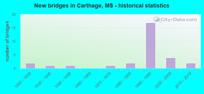
- New bridges - historical statistics
- 21930-1939
- 11940-1949
- 11950-1959
- 11970-1979
- 21980-1989
- 171990-1999
- 42000-2009
- 22010-2019
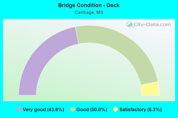
- Bridge Condition - Deck
- 43.8%Very good
- 50.0%Good
- 6.3%Satisfactory
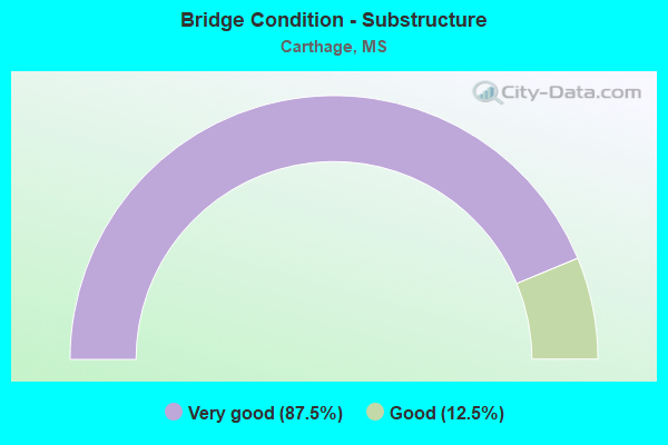
- Bridge Condition - Substructure
- 87.5%Very good
- 12.5%Good
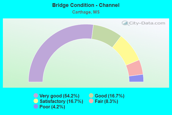
- Bridge Condition - Channel
- 54.2%Very good
- 16.7%Good
- 16.7%Satisfactory
- 8.3%Fair
- 4.2%Poor
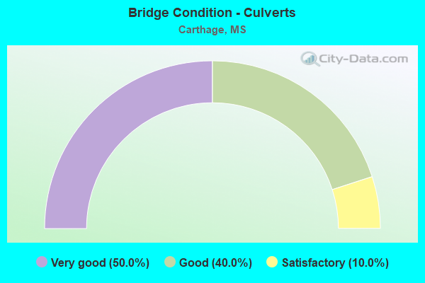
- Bridge Condition - Culverts
- 50.0%Very good
- 40.0%Good
- 10.0%Satisfactory
Find on map >> Show street view
Structure Number: S125, Location: 0.3KM W INT SR35 & REDWTR (Lat: 32.766278, Lng: -89.543528), Route carried "on" structure: Federal lands road 26, Year Built: 1985, Status: Open, Structure Length: 1.03m (3.38ft), Average Daily Traffic: 300 (year 2021), Truck Traffic: 2%, Average Future Daily Traffic: 350 (year 2041), Design Load: HS 20, Features Intersected: REDWATER CREEK
Minimum Vertical Clearance: 30+ m (98+ ft), Kilometerpoint: 0.600, Lanes on structure: 2, Owner: Bureau of Indian Affairs, Approaching Roadway Width: 6.6m (21.7ft), Skew: 1 degrees, Material/Design: Concrete, Design/Construction: Culvert, Number Of Spans In Main Unit: 2, Length of Maximum Span: 5.0m (16.4ft), Curb or Sidewalk Widths: Left: 0.3m (1.0ft), Right: 0.3m (1.0ft), Curb-To-Curb Width: 6.6m (21.7ft), Out-to-Out Width: 12.2m (40.0ft)
Condition: Channel: Good, Culverts: Satisfactory, Operating Rating: 44.2 metric tons, Method Used To Determine Operating Rating: Allowable Stress (AS), Inventory Rating: 32.4 metric tons, Method Used To Determine Inventory Rating: Allowable Stress (AS), Structural Evaluation: Equal to present minimum criteria, Deck Geometry: Meets minimum limits, Waterway Adequacy: Better than present minimum criteria, Approach Roadway Alignment: Equal to present desirable criteria, Designated Inspection Frequency: Every 24 months, Inspection Date: Febuary 2021
Find on map >> Show street view
Structure Number: S136, Location: .36KM W INT SR35 & REDWTR (Lat: 32.766278, Lng: -89.544389), Route carried "on" structure: Federal lands road 26, Year Built: 1994, Status: Open, Structure Length: 1.16m (3.81ft), Average Daily Traffic: 300 (year 2021), Truck Traffic: 2%, Average Future Daily Traffic: 360 (year 2041), Design Load: HS 20, Features Intersected: CARTHAGE CREEK
Minimum Vertical Clearance: 30+ m (98+ ft), Kilometerpoint: 0.800, Lanes on structure: 2, Owner: Bureau of Indian Affairs, Approaching Roadway Width: 7.3m (24.0ft), Skew: 3 degrees, Material/Design: Concrete, Design/Construction: Culvert, Number Of Spans In Main Unit: 2, Length of Maximum Span: 5.6m (18.4ft), Curb or Sidewalk Widths: Left: 0.3m (1.0ft), Right: 0.3m (1.0ft), Curb-To-Curb Width: 7.2m (23.6ft), Out-to-Out Width: 14.4m (47.2ft)
Condition: Channel: Satisfactory, Culverts: Good, Operating Rating: 44.5 metric tons, Method Used To Determine Operating Rating: Allowable Stress (AS), Inventory Rating: 32.7 metric tons, Method Used To Determine Inventory Rating: Allowable Stress (AS), Structural Evaluation: Better than present minimum criteria, Deck Geometry: Meets minimum limits, Waterway Adequacy: Better than present minimum criteria, Approach Roadway Alignment: Equal to present desirable criteria, Designated Inspection Frequency: Every 24 months, Inspection Date: Febuary 2021
Find on map >> Show street view
Structure Number: S14, Location: 0.5KM SE INT. SR36 & SR25 (Lat: 32.768000, Lng: -89.536250), Route carried "on" structure: Federal lands road 2635, Year Built: 1992, Status: Open, Structure Length: 0.63m (2.07ft), Average Daily Traffic: 100 (year 2021), Truck Traffic: 10%, Average Future Daily Traffic: 120 (year 2041), Design Load: HS 20, Features Intersected: UNNAMED CREEK
Minimum Vertical Clearance: 30+ m (98+ ft), Kilometerpoint: 1.400, Lanes on structure: 2, Owner: Bureau of Indian Affairs, Approaching Roadway Width: 7.3m (24.0ft), Material/Design: Concrete, Design/Construction: Culvert, Number Of Spans In Main Unit: 2, Length of Maximum Span: 3.1m (10.2ft), Curb-To-Curb Width: 7.3m (24.0ft), Out-to-Out Width: 14.6m (47.9ft)
Condition: Channel: Very good, Culverts: Good, Operating Rating: 44.2 metric tons, Method Used To Determine Operating Rating: Allowable Stress (AS), Inventory Rating: 32.4 metric tons, Method Used To Determine Inventory Rating: Allowable Stress (AS), Structural Evaluation: Better than present minimum criteria, Deck Geometry: Equal to present minimum criteria, Waterway Adequacy: Equal to present desirable criteria, Approach Roadway Alignment: Equal to present desirable criteria, Designated Inspection Frequency: Every 24 months, Inspection Date: Febuary 2021
Find on map >> Show street view
Structure Number: 31000160401067, Location: 2.6 MI E SR 25 (Lat: 32.713611, Lng: -89.587489), Route carried "on" structure: State highway 16, Year Built: 1939, Status: Open, Structure Length: 1.07m (3.51ft), Average Daily Traffic: 6,400 (year 2020), Truck Traffic: 14%, Average Future Daily Traffic: 6,600 (year 2040), Design Load: H 15, Features Intersected: YELLOW CREEK
Minimum Vertical Clearance: 30+ m (98+ ft), Kilometerpoint: 13.789, Lanes on structure: 2, Base Highway Network: Yes (Inventory Route: 1, Subroute: 1), Owner: State Highway Agency, Approaching Roadway Width: 10.3m (33.8ft), Material/Design: Concrete, Design/Construction: Culvert, Number Of Spans In Main Unit: 2, Length of Maximum Span: 4.9m (16.1ft)
Condition: Channel: Very good, Culverts: Very good, Operating Rating: 68.7 metric tons, Method Used To Determine Operating Rating: Load Factor (LF), Inventory Rating: 41.1 metric tons, Method Used To Determine Inventory Rating: Load Factor (LF), Structural Evaluation: Equal to present desirable criteria, Waterway Adequacy: Equal to present desirable criteria, Approach Roadway Alignment: Equal to present desirable criteria, Designated Inspection Frequency: Every 24 months, Inspection Date: January 2020
Find on map >> Show street view
Structure Number: 3100016040108, Location: 4.0 MI E SR 25 (Lat: 32.721233, Lng: -89.566508), Route carried "on" structure: State highway 16, Year Built: 2004, Status: Open, Structure Length: 7.37m (24.18ft), Average Daily Traffic: 6,400 (year 2020), Truck Traffic: 14%, Average Future Daily Traffic: 6,600 (year 2040), Design Load: HS 20, Features Intersected: PELLAPHALIA CREEK
Minimum Vertical Clearance: 30+ m (98+ ft), Kilometerpoint: 15.929, Lanes on structure: 2, Base Highway Network: Yes (Inventory Route: 1, Subroute: 1), Owner: State Highway Agency, Approaching Roadway Width: 13.4m (44.0ft), Material/Design: Prestressed concrete continuous, Design/Construction: Stringer/Multi-beam, Number Of Spans In Main Unit: 6, Length of Maximum Span: 12.0m (39.4ft), Curb-To-Curb Width: 13.4m (44.0ft), Out-to-Out Width: 14.3m (46.9ft)
Condition: Deck: Very good, Superstructure: Very good, Substructure: Very good, Channel: Good, Operating Rating: 59.3 metric tons, Method Used To Determine Operating Rating: Load Factor (LF), Inventory Rating: 34.3 metric tons, Method Used To Determine Inventory Rating: Load Factor (LF), Structural Evaluation: Equal to present desirable criteria, Deck Geometry: Equal to present minimum criteria, Waterway Adequacy: Equal to present desirable criteria, Approach Roadway Alignment: Equal to present desirable criteria, Designated Inspection Frequency: Every 24 months, Inspection Date: January 2022, Deck Structure Type: Concrete Cast-file-Place
Find on map >> Show street view
Structure Number: 31000160401099, Location: 5.7 MI E SR 25 (Lat: 32.732092, Lng: -89.536478), Route carried "on" structure: State highway 16, Year Built: 1938, Status: Open, Structure Length: 1.65m (5.41ft), Average Daily Traffic: 14,000 (year 2020), Truck Traffic: 5%, Average Future Daily Traffic: 14,000 (year 2040), Design Load: H 15, Features Intersected: TOWN CREEK
Minimum Vertical Clearance: 30+ m (98+ ft), Kilometerpoint: 18.989, Lanes on structure: 4, Base Highway Network: Yes (Inventory Route: 1, Subroute: 1), Owner: State Highway Agency, Approaching Roadway Width: 19.8m (65.0ft), Skew: 3 degrees, Material/Design: Concrete, Design/Construction: Culvert, Number Of Spans In Main Unit: 2, Length of Maximum Span: 6.7m (22.0ft)
Condition: Channel: Very good, Culverts: Good, Operating Rating: 42.1 metric tons, Method Used To Determine Operating Rating: Load Factor (LF), Inventory Rating: 25.3 metric tons, Method Used To Determine Inventory Rating: Load Factor (LF), Structural Evaluation: Equal to present minimum criteria, Waterway Adequacy: Equal to present desirable criteria, Approach Roadway Alignment: Equal to present desirable criteria, Length Of Structure Improvement: 1.65m (5.41ft), Designated Inspection Frequency: Every 24 months, Inspection Date: January 2020, Bridge Improvement Cost: $123,000,000, Roadway Improvement Cost: $200,000,000, Total Project Cost: $374,000,000
Find on map >> Show street view
Structure Number: 31000160401118, Location: 1.8 MI E SR 35 (Lat: 32.742233, Lng: -89.505850), Route carried "on" structure: State highway 16, Year Built: 2004, Status: Open, Structure Length: 3.66m (12.01ft), Average Daily Traffic: 5,900 (year 2020), Truck Traffic: 10%, Average Future Daily Traffic: 6,100 (year 2040), Design Load: HS 20, Features Intersected: POLLARD CREEK
Minimum Vertical Clearance: 30+ m (98+ ft), Kilometerpoint: 22.093, Lanes on structure: 2, Base Highway Network: Yes (Inventory Route: 1, Subroute: 1), Owner: State Highway Agency, Approaching Roadway Width: 13.4m (44.0ft), Material/Design: Prestressed concrete continuous, Design/Construction: Stringer/Multi-beam, Number Of Spans In Main Unit: 3, Length of Maximum Span: 12.2m (40.0ft), Curb-To-Curb Width: 13.4m (44.0ft), Out-to-Out Width: 14.3m (46.9ft)
Condition: Deck: Very good, Superstructure: Very good, Substructure: Very good, Channel: Poor, Operating Rating: 59.3 metric tons, Method Used To Determine Operating Rating: Load Factor (LF), Inventory Rating: 34.3 metric tons, Method Used To Determine Inventory Rating: Load Factor (LF), Structural Evaluation: Equal to present desirable criteria, Deck Geometry: Equal to present minimum criteria, Waterway Adequacy: Equal to present desirable criteria, Approach Roadway Alignment: Equal to present desirable criteria, Designated Inspection Frequency: Every 24 months, Inspection Date: January 2020, Deck Structure Type: Concrete Cast-file-Place
Find on map >> Show street view
Structure Number: 31000160401148, Location: 4.9 MI E SR 35 (Lat: 32.760561, Lng: -89.461164), Route carried "on" structure: State highway 16, Year Built: 2004, Status: Open, Structure Length: 30.24m (99.21ft), Average Daily Traffic: 5,900 (year 2020), Truck Traffic: 10%, Average Future Daily Traffic: 6,100 (year 2040), Design Load: HS 20, Features Intersected: LOBUTCHA CREEK
Minimum Vertical Clearance: 30+ m (98+ ft), Kilometerpoint: 26.757, Lanes on structure: 2, Base Highway Network: Yes (Inventory Route: 1, Subroute: 1), Owner: State Highway Agency, Approaching Roadway Width: 13.4m (44.0ft), Material/Design: Prestressed concrete, Design/Construction: Stringer/Multi-beam, Number Of Spans In Main Unit: 1, Number Of Approach Spans: 20, Length of Maximum Span: 34.1m (111.9ft), Curb-To-Curb Width: 13.4m (44.0ft), Out-to-Out Width: 14.3m (46.9ft)
Condition: Deck: Good, Superstructure: Very good, Substructure: Very good, Channel: Satisfactory, Operating Rating: 59.3 metric tons, Method Used To Determine Operating Rating: Load Factor (LF), Inventory Rating: 25.7 metric tons, Method Used To Determine Inventory Rating: Load Factor (LF), Structural Evaluation: Equal to present minimum criteria, Deck Geometry: Equal to present minimum criteria, Waterway Adequacy: Equal to present desirable criteria, Approach Roadway Alignment: Equal to present desirable criteria, Designated Inspection Frequency: Every 24 months, Inspection Date: January 2020, Deck Structure Type: Concrete Cast-file-Place
Find on map >> Show street view
Structure Number: 31000250400514, Location: 7.0 MI N SR 16 (Lat: 32.769975, Lng: -89.546442), Route carried "on" structure: State highway 25, Year Built: 1986, Status: Open, Structure Length: 0.94m (3.08ft), Average Daily Traffic: 5,200 (year 2020), Truck Traffic: 21%, Average Future Daily Traffic: 7,300 (year 2040), Design Load: HS 20+Mod, Features Intersected: TOWN CREEK
Minimum Vertical Clearance: 30+ m (98+ ft), Kilometerpoint: 28.926, Lanes on structure: 2, Base Highway Network: Yes (Inventory Route: 2, Subroute: 1), Owner: State Highway Agency, Approaching Roadway Width: 12.8m (42.0ft), Material/Design: Concrete, Design/Construction: Culvert, Number Of Spans In Main Unit: 2, Length of Maximum Span: 4.3m (14.1ft)
Condition: Channel: Fair, Culverts: Very good, Operating Rating: 45.0 metric tons, Method Used To Determine Operating Rating: Load Factor (LF), Inventory Rating: 27.0 metric tons, Method Used To Determine Inventory Rating: Load Factor (LF), Structural Evaluation: Equal to present minimum criteria, Waterway Adequacy: Equal to present desirable criteria, Approach Roadway Alignment: Equal to present desirable criteria, Designated Inspection Frequency: Every 24 months, Inspection Date: Febuary 2020
Find on map >> Show street view
Structure Number: 31000250400517A, Location: SR 25 OVER SR 35 (Lat: 32.770639, Lng: -89.540286), Route carried "on" structure: State highway 25, Year Built: 1999, Status: Open, Structure Length: 9.80m (32.15ft), Average Daily Traffic: 2,600 (year 2020), Truck Traffic: 21%, Average Future Daily Traffic: 3,650 (year 2040), Design Load: HS 20, Features Intersected: SR 35
Minimum Vertical Clearance: 30+ m (98+ ft), Kilometerpoint: 28.627, Lanes on structure: 2, Lanes under structure: 4, Base Highway Network: Yes (Inventory Route: 2, Subroute: 1), Owner: State Highway Agency, Approaching Roadway Width: 12.2m (40.0ft), Material/Design: Prestressed concrete continuous, Design/Construction: Stringer/Multi-beam, Number Of Spans In Main Unit: 2, Number Of Approach Spans: 2, Length of Maximum Span: 29.0m (95.1ft), Curb-To-Curb Width: 12.2m (40.0ft), Out-to-Out Width: 13.0m (42.7ft)
Condition: Deck: Good, Superstructure: Very good, Substructure: Very good, Operating Rating: 52.2 metric tons, Method Used To Determine Operating Rating: Load Factor (LF), Inventory Rating: 31.3 metric tons, Method Used To Determine Inventory Rating: Load Factor (LF), Structural Evaluation: Better than present minimum criteria, Deck Geometry: Better than present minimum criteria, Underclear: Superior to present desirable criteria, Approach Roadway Alignment: Equal to present desirable criteria, Designated Inspection Frequency: Every 24 months, Inspection Date: Febuary 2020, Deck Structure Type: Concrete Cast-file-Place
Find on map >> Show street view
Structure Number: 31000250400517B, Location: SR 25 OVER SR 35 (Lat: 32.770328, Lng: -89.541281), Route carried "on" structure: State highway 25, Year Built: 1999, Status: Open, Structure Length: 9.80m (32.15ft), Average Daily Traffic: 2,600 (year 2020), Truck Traffic: 21%, Average Future Daily Traffic: 3,650 (year 2040), Design Load: HS 20, Features Intersected: SR 35
Minimum Vertical Clearance: 30+ m (98+ ft), Kilometerpoint: 29.411, Lanes on structure: 2, Lanes under structure: 4, Base Highway Network: Yes (Inventory Route: 2, Subroute: 1), Owner: State Highway Agency, Approaching Roadway Width: 12.2m (40.0ft), Material/Design: Prestressed concrete continuous, Design/Construction: Stringer/Multi-beam, Number Of Spans In Main Unit: 2, Number Of Approach Spans: 2, Length of Maximum Span: 29.0m (95.1ft), Curb-To-Curb Width: 12.2m (40.0ft), Out-to-Out Width: 13.0m (42.7ft)
Condition: Deck: Good, Superstructure: Very good, Substructure: Very good, Operating Rating: 52.2 metric tons, Method Used To Determine Operating Rating: Load Factor (LF), Inventory Rating: 31.3 metric tons, Method Used To Determine Inventory Rating: Load Factor (LF), Structural Evaluation: Better than present minimum criteria, Deck Geometry: Better than present minimum criteria, Underclear: Superior to present desirable criteria, Approach Roadway Alignment: Equal to present desirable criteria, Designated Inspection Frequency: Every 24 months, Inspection Date: Febuary 2020, Deck Structure Type: Concrete Cast-file-Place
Find on map >> Show street view
Structure Number: 31000250400529, Location: 1.1 MI N SR 35 (Lat: 32.776261, Lng: -89.523131), Route carried "on" structure: State highway 25, Year Built: 1959, Status: Open, Structure Length: 0.91m (2.99ft), Average Daily Traffic: 6,200 (year 2020), Truck Traffic: 16%, Average Future Daily Traffic: 8,700 (year 2040), Design Load: H 15, Features Intersected: POLLARD CREEK
Minimum Vertical Clearance: 30+ m (98+ ft), Kilometerpoint: 31.271, Lanes on structure: 4, Base Highway Network: Yes (Inventory Route: 2, Subroute: 1), Owner: State Highway Agency, Approaching Roadway Width: 17.1m (56.1ft), Skew: 1 degrees, Material/Design: Concrete, Design/Construction: Culvert, Number Of Spans In Main Unit: 2, Length of Maximum Span: 4.4m (14.4ft)
Condition: Channel: Very good, Culverts: Very good, Operating Rating: 55.9 metric tons, Method Used To Determine Operating Rating: Load Factor (LF), Inventory Rating: 33.5 metric tons, Method Used To Determine Inventory Rating: Load Factor (LF), Structural Evaluation: Equal to present desirable criteria, Waterway Adequacy: Equal to present desirable criteria, Approach Roadway Alignment: Equal to present desirable criteria, Designated Inspection Frequency: Every 24 months, Inspection Date: Febuary 2020
Find on map >> Show street view
Structure Number: 31000350401316, Location: 1.4 MI N SR 487 (Lat: 32.700522, Lng: -89.522706), Route carried "on" structure: State highway 35, Year Built: 1995, Status: Open, Structure Length: 3.72m (12.20ft), Average Daily Traffic: 8,100 (year 2020), Truck Traffic: 13%, Average Future Daily Traffic: 8,300 (year 2040), Design Load: HS 20, Features Intersected: PEARL RIVER RELIEF
Minimum Vertical Clearance: 30+ m (98+ ft), Kilometerpoint: 15.298, Lanes on structure: 2, Base Highway Network: Yes (Inventory Route: 3, Subroute: 1), Owner: State Highway Agency, Approaching Roadway Width: 13.4m (44.0ft), Skew: 3 degrees, Material/Design: Prestressed concrete continuous, Design/Construction: Stringer/Multi-beam, Number Of Spans In Main Unit: 3, Length of Maximum Span: 12.2m (40.0ft), Curb-To-Curb Width: 13.4m (44.0ft), Out-to-Out Width: 14.3m (46.9ft)
Condition: Deck: Good, Superstructure: Very good, Substructure: Very good, Channel: Very good, Operating Rating: 60.2 metric tons, Method Used To Determine Operating Rating: Load Factor (LF), Inventory Rating: 31.8 metric tons, Method Used To Determine Inventory Rating: Load Factor (LF), Structural Evaluation: Better than present minimum criteria, Deck Geometry: Equal to present minimum criteria, Waterway Adequacy: Equal to present desirable criteria, Approach Roadway Alignment: Equal to present desirable criteria, Designated Inspection Frequency: Every 24 months, Inspection Date: Febuary 2020, Deck Structure Type: Concrete Cast-file-Place
Find on map >> Show street view
Structure Number: 3100035040132, Location: 0.1 MI N SR 488 (Lat: 32.705397, Lng: -89.525667), Route carried "on" structure: State highway 35, Year Built: 1995, Status: Open, Structure Length: 39.68m (130.18ft), Average Daily Traffic: 9,100 (year 2020), Truck Traffic: 10%, Average Future Daily Traffic: 9,400 (year 2040), Design Load: HS 20, Features Intersected: PEARL RIVER
Minimum Vertical Clearance: 30+ m (98+ ft), Kilometerpoint: 15.908, Lanes on structure: 2, Base Highway Network: Yes (Inventory Route: 3, Subroute: 1), Owner: State Highway Agency, Approaching Roadway Width: 13.4m (44.0ft), Material/Design: Steel continuous, Design/Construction: Stringer/Multi-beam, Number Of Spans In Main Unit: 6, Number Of Approach Spans: 2, Length of Maximum Span: 61.0m (200.1ft), Curb-To-Curb Width: 13.4m (44.0ft), Out-to-Out Width: 14.3m (46.9ft)
Condition: Deck: Good, Superstructure: Very good, Substructure: Very good, Channel: Very good, Operating Rating: 55.3 metric tons, Method Used To Determine Operating Rating: Load Factor (LF), Inventory Rating: 31.7 metric tons, Method Used To Determine Inventory Rating: Load Factor (LF), Structural Evaluation: Better than present minimum criteria, Deck Geometry: Equal to present minimum criteria, Waterway Adequacy: Equal to present desirable criteria, Approach Roadway Alignment: Equal to present desirable criteria, Designated Inspection Frequency: Every 24 months, Inspection Date: March 2020, Deck Structure Type: Concrete Cast-file-Place
Find on map >> Show street view
Structure Number: 31000350401324, Location: 0.6 MI N SR 488 (Lat: 32.711439, Lng: -89.528239), Route carried "on" structure: State highway 35, Year Built: 1995, Status: Open, Structure Length: 16.52m (54.20ft), Average Daily Traffic: 9,100 (year 2020), Truck Traffic: 10%, Average Future Daily Traffic: 9,400 (year 2040), Design Load: HS 20, Features Intersected: POLLARD CREEK
Minimum Vertical Clearance: 30+ m (98+ ft), Kilometerpoint: 16.620, Lanes on structure: 2, Base Highway Network: Yes (Inventory Route: 3, Subroute: 1), Owner: State Highway Agency, Approaching Roadway Width: 13.4m (44.0ft), Material/Design: Prestressed concrete, Design/Construction: Stringer/Multi-beam, Number Of Spans In Main Unit: 1, Number Of Approach Spans: 12, Length of Maximum Span: 18.3m (60.0ft), Curb-To-Curb Width: 13.4m (44.0ft), Out-to-Out Width: 14.3m (46.9ft)
Condition: Deck: Satisfactory, Superstructure: Very good, Substructure: Very good, Channel: Good, Operating Rating: 63.8 metric tons, Method Used To Determine Operating Rating: Load Factor (LF), Inventory Rating: 30.6 metric tons, Method Used To Determine Inventory Rating: Load Factor (LF), Structural Evaluation: Better than present minimum criteria, Deck Geometry: Equal to present minimum criteria, Waterway Adequacy: Equal to present desirable criteria, Approach Roadway Alignment: Equal to present desirable criteria, Designated Inspection Frequency: Every 24 months, Inspection Date: March 2020, Deck Structure Type: Concrete Cast-file-Place
Find on map >> Show street view
Structure Number: 31000350401328, Location: 0.9 MI N SR 488 (Lat: 32.716339, Lng: -89.530286), Route carried "on" structure: State highway 35, Year Built: 1995, Status: Open, Structure Length: 5.55m (18.21ft), Average Daily Traffic: 9,100 (year 2020), Truck Traffic: 10%, Average Future Daily Traffic: 9,400 (year 2040), Design Load: HS 20, Features Intersected: RELIEF
Minimum Vertical Clearance: 30+ m (98+ ft), Kilometerpoint: 17.196, Lanes on structure: 2, Base Highway Network: Yes (Inventory Route: 3, Subroute: 1), Owner: State Highway Agency, Approaching Roadway Width: 13.4m (44.0ft), Material/Design: Prestressed concrete continuous, Design/Construction: Stringer/Multi-beam, Number Of Spans In Main Unit: 4, Length of Maximum Span: 18.3m (60.0ft), Curb-To-Curb Width: 13.4m (44.0ft), Out-to-Out Width: 14.3m (46.9ft)
Condition: Deck: Good, Superstructure: Very good, Substructure: Very good, Channel: Very good, Operating Rating: 54.1 metric tons, Method Used To Determine Operating Rating: Load Factor (LF), Inventory Rating: 26.8 metric tons, Method Used To Determine Inventory Rating: Load Factor (LF), Structural Evaluation: Equal to present minimum criteria, Deck Geometry: Equal to present minimum criteria, Waterway Adequacy: Equal to present desirable criteria, Approach Roadway Alignment: Equal to present desirable criteria, Designated Inspection Frequency: Every 24 months, Inspection Date: Febuary 2020, Deck Structure Type: Concrete Cast-file-Place
Find on map >> Show street view
Structure Number: 31004880400016, Location: 1.6 MI E SR 35 (Lat: 32.700867, Lng: -89.497689), Route carried "on" structure: State highway 488, Year Built: 1996, Status: Open, Structure Length: 4.18m (13.71ft), Average Daily Traffic: 980 (year 2020), Truck Traffic: 12%, Average Future Daily Traffic: 980 (year 2040), Design Load: HS 20, Features Intersected: POTTOCK CREEK
Minimum Vertical Clearance: 30+ m (98+ ft), Kilometerpoint: 2.697, Lanes on structure: 2, Owner: State Highway Agency, Approaching Roadway Width: 12.2m (40.0ft), Material/Design: Prestressed concrete continuous, Design/Construction: Stringer/Multi-beam, Number Of Spans In Main Unit: 3, Length of Maximum Span: 13.7m (44.9ft), Curb-To-Curb Width: 12.2m (40.0ft), Out-to-Out Width: 13.0m (42.7ft)
Condition: Deck: Good, Superstructure: Very good, Substructure: Very good, Channel: Very good, Operating Rating: 59.0 metric tons, Method Used To Determine Operating Rating: Load Factor (LF), Inventory Rating: 35.3 metric tons, Method Used To Determine Inventory Rating: Load Factor (LF), Structural Evaluation: Equal to present desirable criteria, Deck Geometry: Equal to present desirable criteria, Waterway Adequacy: Equal to present desirable criteria, Approach Roadway Alignment: Equal to present desirable criteria, Designated Inspection Frequency: Every 24 months, Inspection Date: Febuary 2020, Deck Structure Type: Concrete Cast-file-Place
Find on map >> Show street view
Structure Number: SA4000000000002, Location: SEC 20 T 9N R 6E B (Lat: 32.621333, Lng: -89.702639), Route carried "on" structure: County highway 433, Year Built: 1997, Status: Open, Structure Length: 0.80m (2.62ft), Average Daily Traffic: 220 (year 2015), Truck Traffic: 8%, Average Future Daily Traffic: 330 (year 2030), Design Load: HS 20, Features Intersected: GIBBS CREEK, Facility Carried by Structure: UTAH ROAD
Minimum Vertical Clearance: 30+ m (98+ ft), Kilometerpoint: 6.115, Lanes on structure: 2, Owner: County Highway Agency, Approaching Roadway Width: 6.7m (22.0ft), Material/Design: Concrete, Design/Construction: Culvert, Number Of Spans In Main Unit: 2, Length of Maximum Span: 3.7m (12.1ft)
Condition: Channel: Good, Culverts: Very good, Operating Rating: 69.0 metric tons, Method Used To Determine Operating Rating: Load Factor (LF) rating reported by rating factor (RF) method using MS18 loading, Inventory Rating: 41.5 metric tons, Method Used To Determine Inventory Rating: Load Factor (LF) rating reported by rating factor (RF) method using MS18 loading, Structural Evaluation: Equal to present desirable criteria, Waterway Adequacy: Equal to present desirable criteria, Approach Roadway Alignment: Equal to present desirable criteria, Length Of Structure Improvement: 0.80m (2.62ft), Designated Inspection Frequency: Every 24 months, Inspection Date: March 2021, Bridge Improvement Cost: $250,000, Roadway Improvement Cost: $100,000, Total Project Cost: $350,000 ( Estimate for 2019)
Find on map >> Show street view
Structure Number: SA4000000000035, Location: SEC 1 T10N R 7E B (Lat: 32.748997, Lng: -89.540117), Route carried "on" structure: County highway 521, Year Built: 2005, Status: Open, Structure Length: 1.08m (3.54ft), Average Daily Traffic: 1,400 (year 2015), Truck Traffic: 8%, Average Future Daily Traffic: 2,100 (year 2030), Design Load: HS 20, Features Intersected: TOWN CREEK, Facility Carried by Structure: CART.-TH'STOWN RD.
Minimum Vertical Clearance: 30+ m (98+ ft), Kilometerpoint: 0.160, Lanes on structure: 2, Owner: County Highway Agency, Approaching Roadway Width: 7.3m (24.0ft), Skew: 3 degrees, Material/Design: Concrete, Design/Construction: Culvert, Number Of Spans In Main Unit: 2, Length of Maximum Span: 4.3m (14.1ft)
Condition: Channel: Satisfactory, Culverts: Very good, Operating Rating: 54.8 metric tons, Method Used To Determine Operating Rating: Load Factor (LF) rating reported by rating factor (RF) method using MS18 loading, Inventory Rating: 32.7 metric tons, Method Used To Determine Inventory Rating: Load Factor (LF) rating reported by rating factor (RF) method using MS18 loading, Structural Evaluation: Equal to present desirable criteria, Waterway Adequacy: Equal to present desirable criteria, Approach Roadway Alignment: Better than present minimum criteria, Length Of Structure Improvement: 1.08m (3.54ft), Designated Inspection Frequency: Every 24 months, Inspection Date: March 2021, Bridge Improvement Cost: $250,000, Roadway Improvement Cost: $100,000, Total Project Cost: $350,000 ( Estimate for 2019)
Find on map >> Show street view
Structure Number: SA4000000000036, Location: SEC 1 T10N R 7E (Lat: 32.742900, Lng: -89.539683), Route carried "on" structure: City street 342, Year Built: 1994, Status: Open, Structure Length: 2.10m (6.89ft), Average Daily Traffic: 400 (year 2015), Truck Traffic: 8%, Average Future Daily Traffic: 600 (year 2035), Design Load: H 15, Features Intersected: TOWN CREEK, Facility Carried by Structure: COTTEN BLVD
Minimum Vertical Clearance: 30+ m (98+ ft), Kilometerpoint: 0.482, Lanes on structure: 2, Owner: City or Municipal Highway Agency, Approaching Roadway Width: 6.1m (20.0ft), Material/Design: Concrete, Design/Construction: Channel Beam, Number Of Spans In Main Unit: 3, Length of Maximum Span: 9.4m (30.8ft), Curb or Sidewalk Widths: Left: 0.2m (0.7ft), Right: 0.2m (0.7ft), Curb-To-Curb Width: 8.1m (26.6ft), Out-to-Out Width: 8.5m (27.9ft)
Condition: Deck: Very good, Superstructure: Very good, Substructure: Very good, Channel: Very good, Operating Rating: 53.5 metric tons, Method Used To Determine Operating Rating: Load Factor (LF) rating reported by rating factor (RF) method using MS18 loading, Inventory Rating: 32.1 metric tons, Method Used To Determine Inventory Rating: Load Factor (LF) rating reported by rating factor (RF) method using MS18 loading, Structural Evaluation: Better than present minimum criteria, Deck Geometry: Somewhat better than minimum adequacy, Waterway Adequacy: Equal to present desirable criteria, Approach Roadway Alignment: Equal to present desirable criteria, Length Of Structure Improvement: 3.05m (10.01ft), Designated Inspection Frequency: Every 24 months, Inspection Date: Febuary 2021, Bridge Improvement Cost: $382,000, Roadway Improvement Cost: $100,000, Total Project Cost: $482,000 ( Estimate for 2021), Deck Structure Type: Concrete Precast Panels, Wearing Surface/Protective System: Wearing Surface: Bituminous
Find on map >> Show street view
Structure Number: SA4000000000037, Location: SEC 1 T10N R 7E (Lat: 32.738800, Lng: -89.539250), Route carried "on" structure: City street 461, Year Built: 2010, Status: Open, Structure Length: 2.38m (7.81ft), Average Daily Traffic: 480 (year 2015), Truck Traffic: 8%, Average Future Daily Traffic: 720 (year 2035), Design Load: HL 93, Features Intersected: TOWN CREEK, Facility Carried by Structure: WILLIAMS ST
Minimum Vertical Clearance: 30+ m (98+ ft), Kilometerpoint: 1.046, Lanes on structure: 2, Owner: City or Municipal Highway Agency, Approaching Roadway Width: 7.9m (25.9ft), Material/Design: Concrete, Design/Construction: Channel Beam, Number Of Spans In Main Unit: 3, Length of Maximum Span: 12.2m (40.0ft), Curb or Sidewalk Widths: Left: 0.5m (1.6ft), Right: 0.5m (1.6ft), Curb-To-Curb Width: 8.5m (27.9ft), Out-to-Out Width: 9.5m (31.2ft)
Condition: Deck: Very good, Superstructure: Very good, Substructure: Very good, Channel: Very good, Operating Rating: 44.7 metric tons, Method Used To Determine Operating Rating: Load and Resistance Factor Rating (LRFR) rating reported by rating factor(RF) method using HL-93 loadings, Inventory Rating: 34.3 metric tons, Method Used To Determine Inventory Rating: Load and Resistance Factor Rating (LRFR) rating reported by rating factor(RF) method using HL-93 loadings, Structural Evaluation: Equal to present desirable criteria, Deck Geometry: Somewhat better than minimum adequacy, Waterway Adequacy: Equal to present desirable criteria, Approach Roadway Alignment: Equal to present desirable criteria, Length Of Structure Improvement: 3.60m (11.81ft), Designated Inspection Frequency: Every 24 months, Inspection Date: Febuary 2021, Bridge Improvement Cost: $413,000, Roadway Improvement Cost: $100,000, Total Project Cost: $513,000 ( Estimate for 2019), Deck Structure Type: Concrete Precast Panels, Wearing Surface/Protective System: Wearing Surface: Monolithic Concrete
Find on map >> Show street view
Structure Number: SA4000000000038, Location: SEC 10 T10N R 7E (Lat: 32.725781, Lng: -89.567650), Route carried "on" structure: County highway 183, Year Built: 1997, Status: Open, Structure Length: 4.66m (15.29ft), Average Daily Traffic: 320 (year 2015), Truck Traffic: 8%, Average Future Daily Traffic: 480 (year 2035), Design Load: HS 20, Features Intersected: PELLAPHALIA CREEK, Facility Carried by Structure: OLD CANTON ROAD
Minimum Vertical Clearance: 30+ m (98+ ft), Kilometerpoint: 3.057, Lanes on structure: 2, Owner: County Highway Agency, Approaching Roadway Width: 7.3m (24.0ft), Material/Design: Prestressed concrete, Design/Construction: Stringer/Multi-beam, Number Of Spans In Main Unit: 4, Length of Maximum Span: 18.3m (60.0ft), Curb or Sidewalk Widths: Left: 0.5m (1.6ft), Right: 0.5m (1.6ft), Curb-To-Curb Width: 9.1m (29.9ft), Out-to-Out Width: 10.1m (33.1ft)
Condition: Deck: Very good, Superstructure: Very good, Substructure: Very good, Channel: Very good, Operating Rating: 68.7 metric tons, Method Used To Determine Operating Rating: Load Factor (LF) rating reported by rating factor (RF) method using MS18 loading, Inventory Rating: 41.1 metric tons, Method Used To Determine Inventory Rating: Load Factor (LF) rating reported by rating factor (RF) method using MS18 loading, Structural Evaluation: Equal to present desirable criteria, Deck Geometry: Equal to present minimum criteria, Waterway Adequacy: Equal to present desirable criteria, Approach Roadway Alignment: Equal to present desirable criteria, Length Of Structure Improvement: 5.88m (19.29ft), Designated Inspection Frequency: Every 24 months, Inspection Date: Febuary 2021, Bridge Improvement Cost: $676,000, Roadway Improvement Cost: $100,000, Total Project Cost: $776,000 ( Estimate for 2021), Deck Structure Type: Concrete Cast-file-Place, Wearing Surface/Protective System: Wearing Surface: Monolithic Concrete
Find on map >> Show street view
Structure Number: SA4000000000039, Location: SEC 12 T10N R 7E (Lat: 32.736469, Lng: -89.538131), Route carried "on" structure: City street 482, Year Built: 1999, Status: Open, Structure Length: 2.83m (9.28ft), Average Daily Traffic: 800 (year 2015), Truck Traffic: 8%, Average Future Daily Traffic: 1,200 (year 2035), Design Load: HS 20, Features Intersected: TOWN CREEK, Facility Carried by Structure: OLD CANTON ROAD
Minimum Vertical Clearance: 30+ m (98+ ft), Kilometerpoint: 2.092, Lanes on structure: 2, Owner: City or Municipal Highway Agency, Approaching Roadway Width: 7.9m (25.9ft), Material/Design: Concrete, Design/Construction: Channel Beam, Number Of Spans In Main Unit: 3, Length of Maximum Span: 9.4m (30.8ft), Curb or Sidewalk Widths: Left: 0.5m (1.6ft), Right: 0.5m (1.6ft), Curb-To-Curb Width: 9.1m (29.9ft), Out-to-Out Width: 10.1m (33.1ft)
Condition: Deck: Very good, Superstructure: Very good, Substructure: Very good, Channel: Very good, Operating Rating: 59.3 metric tons, Method Used To Determine Operating Rating: Load Factor (LF) rating reported by rating factor (RF) method using MS18 loading, Inventory Rating: 35.6 metric tons, Method Used To Determine Inventory Rating: Load Factor (LF) rating reported by rating factor (RF) method using MS18 loading, Structural Evaluation: Equal to present desirable criteria, Deck Geometry: Equal to present minimum criteria, Waterway Adequacy: Equal to present desirable criteria, Approach Roadway Alignment: Equal to present desirable criteria, Length Of Structure Improvement: 4.05m (13.29ft), Designated Inspection Frequency: Every 24 months, Inspection Date: Febuary 2021, Bridge Improvement Cost: $462,000, Roadway Improvement Cost: $100,000, Total Project Cost: $562,000 ( Estimate for 2019), Deck Structure Type: Concrete Precast Panels, Wearing Surface/Protective System: Wearing Surface: Monolithic Concrete
Find on map >> Show street view
Structure Number: SA400000000004, Location: SEC 34 T10N R 7E B (Lat: 32.667333, Lng: -89.566883), Route carried "on" structure: County highway 1548, Year Built: 1975, Status: Open, Structure Length: 3.66m (12.01ft), Average Daily Traffic: 580 (year 2015), Truck Traffic: 8%, Average Future Daily Traffic: 870 (year 2030), Design Load: HS 15, Features Intersected: CREAL FIELD BRANCH, Facility Carried by Structure: PLEASANT HILL RD
Minimum Vertical Clearance: 30+ m (98+ ft), Kilometerpoint: 8.368, Lanes on structure: 2, Owner: County Highway Agency, Approaching Roadway Width: 6.7m (22.0ft), Material/Design: Prestressed concrete, Design/Construction: Stringer/Multi-beam, Number Of Spans In Main Unit: 3, Length of Maximum Span: 12.2m (40.0ft), Curb or Sidewalk Widths: Left: 0.4m (1.3ft), Right: 0.4m (1.3ft), Curb-To-Curb Width: 7.9m (25.9ft), Out-to-Out Width: 8.8m (28.9ft)
Condition: Deck: Good, Superstructure: Very good, Substructure: Good, Channel: Fair, Operating Rating: 60.3 metric tons, Method Used To Determine Operating Rating: Load Factor (LF) rating reported by rating factor (RF) method using MS18 loading, Inventory Rating: 27.2 metric tons, Method Used To Determine Inventory Rating: Load Factor (LF) rating reported by rating factor (RF) method using MS18 loading, Structural Evaluation: Equal to present minimum criteria, Deck Geometry: Somewhat better than minimum adequacy, Waterway Adequacy: Equal to present desirable criteria, Approach Roadway Alignment: Better than present minimum criteria, Length Of Structure Improvement: 4.88m (16.01ft), Designated Inspection Frequency: Every 24 months, Inspection Date: March 2021, Bridge Improvement Cost: $560,000, Roadway Improvement Cost: $100,000, Total Project Cost: $660,000 ( Estimate for 2019), Deck Structure Type: Concrete Cast-file-Place, Wearing Surface/Protective System: Wearing Surface: Monolithic Concrete
Find on map >> Show street view
Structure Number: SA4000000000064, Location: SEC 30 T11N R 8E (Lat: 32.771556, Lng: -89.519083), Route carried "on" structure: County highway 1519, Year Built: 1948, Status: Open, Structure Length: 0.75m (2.46ft), Average Daily Traffic: 1,100 (year 2016), Truck Traffic: 8%, Average Future Daily Traffic: 1,650 (year 2036), Design Load: HS 15, Features Intersected: POLLARD CREEK, Facility Carried by Structure: N. JORDAN STREET
Minimum Vertical Clearance: 30+ m (98+ ft), Kilometerpoint: 4.023, Lanes on structure: 2, Owner: County Highway Agency, Approaching Roadway Width: 5.5m (18.0ft), Material/Design: Concrete, Design/Construction: Culvert, Number Of Spans In Main Unit: 2, Length of Maximum Span: 3.7m (12.1ft)
Condition: Channel: Satisfactory, Culverts: Good, Operating Rating: 56.1 metric tons, Method Used To Determine Operating Rating: Load Factor (LF) rating reported by rating factor (RF) method using MS18 loading, Inventory Rating: 33.7 metric tons, Method Used To Determine Inventory Rating: Load Factor (LF) rating reported by rating factor (RF) method using MS18 loading, Structural Evaluation: Better than present minimum criteria, Waterway Adequacy: Equal to present desirable criteria, Approach Roadway Alignment: Equal to present desirable criteria, Length Of Structure Improvement: 0.75m (2.46ft), Designated Inspection Frequency: Every 24 months, Inspection Date: Febuary 2020, Bridge Improvement Cost: $250,000, Roadway Improvement Cost: $100,000, Total Project Cost: $350,000 ( Estimate for 2020)
Find on map >> Show street view
Structure Number: SA400000000A041, Location: SEC 6 T10N R 8E (Lat: 32.747250, Lng: -89.508267), Route carried "on" structure: City street 484, Year Built: 2013, Status: Open, Structure Length: 2.38m (7.81ft), Average Daily Traffic: 240 (year 2016), Truck Traffic: 8%, Average Future Daily Traffic: 360 (year 2036), Design Load: HL 93, Features Intersected: POLLARD CREEK, Facility Carried by Structure: FRANKLIN STREET
Minimum Vertical Clearance: 30+ m (98+ ft), Kilometerpoint: 0.165, Lanes on structure: 2, Owner: City or Municipal Highway Agency, Approaching Roadway Width: 8.1m (26.6ft), Material/Design: Concrete, Design/Construction: Channel Beam, Number Of Spans In Main Unit: 3, Length of Maximum Span: 12.2m (40.0ft), Curb or Sidewalk Widths: Left: 0.5m (1.6ft), Right: 0.5m (1.6ft), Curb-To-Curb Width: 8.5m (27.9ft), Out-to-Out Width: 9.5m (31.2ft)
Condition: Deck: Very good, Superstructure: Very good, Substructure: Good, Channel: Very good, Operating Rating: 44.7 metric tons, Method Used To Determine Operating Rating: Load and Resistance Factor Rating (LRFR) rating reported by rating factor(RF) method using HL-93 loadings, Inventory Rating: 34.3 metric tons, Method Used To Determine Inventory Rating: Load and Resistance Factor Rating (LRFR) rating reported by rating factor(RF) method using HL-93 loadings, Structural Evaluation: Better than present minimum criteria, Deck Geometry: Equal to present minimum criteria, Waterway Adequacy: Equal to present desirable criteria, Approach Roadway Alignment: Better than present minimum criteria, Length Of Structure Improvement: 3.60m (11.81ft), Designated Inspection Frequency: Every 24 months, Inspection Date: Febuary 2020, Bridge Improvement Cost: $414,000, Roadway Improvement Cost: $100,000, Total Project Cost: $514,000 ( Estimate for 2020), Deck Structure Type: Concrete Precast Panels, Wearing Surface/Protective System: Wearing Surface: Monolithic Concrete
Find on map >> Show street view
Structure Number: 31000250400517A, Location: SR 25 OVER SR 35 (Lat: 32.770600, Lng: -89.540931), Route carried "under" structure: State highway 35, Year Built: 1999, Structure Length: 0. m, Average Daily Traffic: 2,200 (year 2017), Truck Traffic: 8%, Features Intersected: SR 35, Facility Carried by Structure: SR 25
Minimum Vertical Clearance: 5.37m (17.62ft), Kilometerpoint: 0.497, Lanes on structure: 2, Lanes under structure: 4, Material/Design: Prestressed concrete continuous, Design/Construction: Stringer/Multi-beam, Length of Maximum Span: 29.0m (95.1ft)
Find on map >> Show street view
Structure Number: 31000250400517A, Location: SR 25 OVER SR 35 (Lat: 32.770619, Lng: -89.540639), Route carried "under" structure: State highway 35, Year Built: 1999, Structure Length: 0. m, Average Daily Traffic: 2,200 (year 2017), Truck Traffic: 8%, Features Intersected: SR 35, Facility Carried by Structure: SR 25
Minimum Vertical Clearance: 5.48m (17.98ft), Kilometerpoint: 23.318, Lanes on structure: 2, Lanes under structure: 4, Material/Design: Prestressed concrete continuous, Design/Construction: Stringer/Multi-beam, Length of Maximum Span: 29.0m (95.1ft)
Find on map >> Show street view
Structure Number: 31000250400517B, Location: SR 25 OVER SR 35 (Lat: 32.770361, Lng: -89.540900), Route carried "under" structure: State highway 35, Year Built: 1999, Structure Length: 0. m, Average Daily Traffic: 3,100 (year 2017), Truck Traffic: 8%, Features Intersected: SR 35, Facility Carried by Structure: SR 25
Minimum Vertical Clearance: 5.95m (19.52ft), Kilometerpoint: 0.525, Lanes on structure: 2, Lanes under structure: 4, Material/Design: Prestressed concrete continuous, Design/Construction: Stringer/Multi-beam, Length of Maximum Span: 29.0m (95.1ft)
Find on map >> Show street view
Structure Number: 31000250400517B, Location: SR 25 OVER SR 35 (Lat: 32.770381, Lng: -89.540611), Route carried "under" structure: State highway 35, Year Built: 1999, Structure Length: 0. m, Average Daily Traffic: 3,100 (year 2017), Truck Traffic: 8%, Features Intersected: SR 35, Facility Carried by Structure: SR 25
Minimum Vertical Clearance: 6.07m (19.91ft), Kilometerpoint: 23.290, Lanes on structure: 2, Lanes under structure: 4, Material/Design: Prestressed concrete continuous, Design/Construction: Stringer/Multi-beam, Length of Maximum Span: 29.0m (95.1ft)