Bridge Statistics for Cassville, West Virginia (WV)
Condition, Traffic, Stress, Structural Evaluation, Project Costs
- National Bridge Inventory (NBI) Statistics
- 24Number of bridges
- 180ft / 54.6mTotal length
- $6,017,000Total costs
- 120,545Total average daily traffic
- 13,920Total average daily truck traffic
- National Bridge Inventory (NBI) Registered Bridges for Cassville
- No street view available for this location
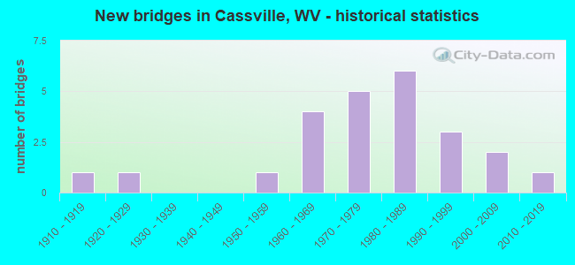
- New bridges - historical statistics
- 11910-1919
- 11920-1929
- 11950-1959
- 41960-1969
- 51970-1979
- 61980-1989
- 31990-1999
- 22000-2009
- 12010-2019
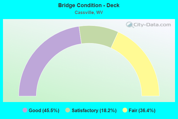
- Bridge Condition - Deck
- 45.5%Good
- 18.2%Satisfactory
- 36.4%Fair
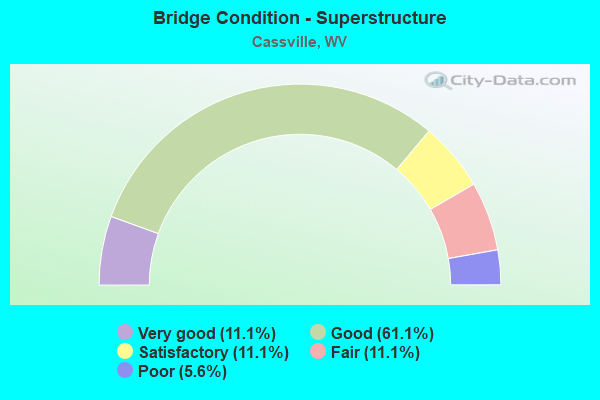
- Bridge Condition - Superstructure
- 11.1%Very good
- 61.1%Good
- 11.1%Satisfactory
- 11.1%Fair
- 5.6%Poor
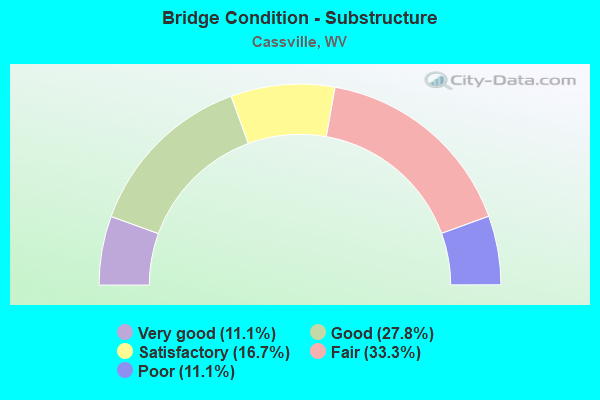
- Bridge Condition - Substructure
- 11.1%Very good
- 27.8%Good
- 16.7%Satisfactory
- 33.3%Fair
- 11.1%Poor
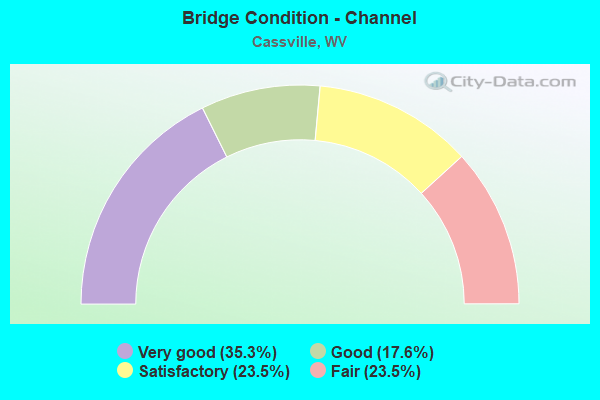
- Bridge Condition - Channel
- 35.3%Very good
- 17.6%Good
- 23.5%Satisfactory
- 23.5%Fair
Find on map >> Show street view
Structure Number: 31A015, Location: 0.01 MI WEST US ROUTE 19 (Lat: 39.668600, Lng: -80.029700), Route carried "on" structure: State highway 700, Year Built: 1921, Status: Posted for load, Structure Length: 0.82m (2.69ft), Average Daily Traffic: 6,200 (year 2019), Truck Traffic: 6%, Average Future Daily Traffic: 8,000 (year 2041), Features Intersected: GUSTON RUN, Facility Carried by Structure: WV ROUTE 7
Minimum Vertical Clearance: 30+ m (98+ ft), Kilometerpoint: 44.627, Lanes on structure: 2, Base Highway Network: Yes, Owner: State Highway Agency, Approaching Roadway Width: 7.9m (25.9ft), Material/Design: Concrete, Design/Construction: Slab, Number Of Spans In Main Unit: 1, Length of Maximum Span: 7.3m (24.0ft), Curb-To-Curb Width: 9.5m (31.2ft), Out-to-Out Width: 10.0m (32.8ft)
Condition: Deck: Fair, Superstructure: Poor, Substructure: Fair, Channel: Satisfactory, Operating Rating: 53.5 metric tons, Method Used To Determine Operating Rating: Field evaluation and documented engineering judgment, Inventory Rating: 24.5 metric tons, Method Used To Determine Inventory Rating: Field evaluation and documented engineering judgment, Structural Evaluation: Meets minimum limits, Deck Geometry: High priority of corrective action, Waterway Adequacy: Equal to present minimum criteria, Approach Roadway Alignment: Better than present minimum criteria, Length Of Structure Improvement: 1.40m (4.59ft), Designated Inspection Frequency: Every 24 months, Inspection Date: December 2021, Bridge Improvement Cost: $268,000, Roadway Improvement Cost: $199,000, Total Project Cost: $742,000 ( Estimate for 2022), Deck Structure Type: Concrete Cast-file-Place, Wearing Surface/Protective System: Wearing Surface: Bituminous
Find on map >> Show street view
Structure Number: 31A091, Location: 0.07 MI SOUTH WV RT 7 (Lat: 39.679800, Lng: -80.108500), Route carried "on" structure: County highway 3700, Year Built: 1989, Status: Open, Structure Length: 1.54m (5.05ft), Average Daily Traffic: 500 (year 2019), Truck Traffic: 6%, Average Future Daily Traffic: 775 (year 2041), Design Load: HS 25 or greater, Features Intersected: DOLLS RUN, Facility Carried by Structure: MONONGALIA CR 37
Minimum Vertical Clearance: 30+ m (98+ ft), Kilometerpoint: 14.903, Lanes on structure: 2, Owner: State Highway Agency, Approaching Roadway Width: 5.2m (17.1ft), Skew: 3 degrees, Material/Design: Prestressed concrete, Design/Construction: Box Beam or Girders - Multiple, Number Of Spans In Main Unit: 1, Length of Maximum Span: 14.0m (45.9ft), Curb-To-Curb Width: 6.1m (20.0ft), Out-to-Out Width: 6.5m (21.3ft)
Condition: Superstructure: Satisfactory, Substructure: Good, Channel: Good, Operating Rating: 88.9 metric tons, Method Used To Determine Operating Rating: Load Factor (LF), Inventory Rating: 59.9 metric tons, Method Used To Determine Inventory Rating: Load Factor (LF), Structural Evaluation: Equal to present minimum criteria, Deck Geometry: High priority of corrective action, Waterway Adequacy: Equal to present minimum criteria, Approach Roadway Alignment: Equal to present minimum criteria, Designated Inspection Frequency: Every 24 months, Inspection Date: November 2021, Deck Structure Type: Other, Wearing Surface/Protective System: Wearing Surface: Bituminous, Deck Protection: Epoxy Coated Reinforcing
Find on map >> Show street view
Structure Number: 31A1, Location: 0.01 MI NORTH MGL CO 43/9 (Lat: 39.666100, Lng: -80.063100), Route carried "on" structure: County highway 4300, Year Built: 1981, Status: Open, Structure Length: 0.84m (2.76ft), Average Daily Traffic: 800 (year 2019), Truck Traffic: 8%, Average Future Daily Traffic: 1,100 (year 0020), Design Load: HS 20, Features Intersected: SCOTTS RUN, Facility Carried by Structure: MONO CO RT 43
Minimum Vertical Clearance: 30+ m (98+ ft), Kilometerpoint: 6.727, Lanes on structure: 2, Owner: State Highway Agency, Approaching Roadway Width: 6.7m (22.0ft), Material/Design: Prestressed concrete, Design/Construction: Slab, Number Of Spans In Main Unit: 1, Length of Maximum Span: 7.9m (25.9ft), Curb-To-Curb Width: 5.9m (19.4ft), Out-to-Out Width: 6.1m (20.0ft)
Condition: Superstructure: Good, Substructure: Fair, Channel: Fair, Operating Rating: 71.7 metric tons, Method Used To Determine Operating Rating: Field evaluation and documented engineering judgment, Inventory Rating: 32.7 metric tons, Method Used To Determine Inventory Rating: Field evaluation and documented engineering judgment, Structural Evaluation: Somewhat better than minimum adequacy, Deck Geometry: High priority of replacement, Waterway Adequacy: Somewhat better than minimum adequacy, Approach Roadway Alignment: Equal to present desirable criteria, Length Of Structure Improvement: 0.85m (2.79ft), Designated Inspection Frequency: Every 24 months, Other Special Inspection Frequency: Every 12 months, Inspection Date: November 2021, Other Special Inspection Date: November 2021, Bridge Improvement Cost: $298,000, Roadway Improvement Cost: $237,000, Total Project Cost: $583,000 ( Estimate for 2022), Deck Structure Type: Other, Wearing Surface/Protective System: Wearing Surface: Bituminous
Find on map >> Show street view
Structure Number: 31A103, Location: 0.25 MI NORTH WV RT 7 (Lat: 39.666200, Lng: -80.063100), Route carried "on" structure: County highway 4300, Year Built: 1988, Status: Open, Structure Length: 0.87m (2.85ft), Average Daily Traffic: 800 (year 2019), Truck Traffic: 6%, Average Future Daily Traffic: 1,240 (year 2041), Design Load: HS 25 or greater, Features Intersected: BRANCH OF SCOTTS RUN, Facility Carried by Structure: MONO CO RT 43
Minimum Vertical Clearance: 30+ m (98+ ft), Kilometerpoint: 7.049, Lanes on structure: 2, Owner: State Highway Agency, Approaching Roadway Width: 4.9m (16.1ft), Skew: 3 degrees, Material/Design: Prestressed concrete, Design/Construction: Box Beam or Girders - Multiple, Number Of Spans In Main Unit: 1, Length of Maximum Span: 8.2m (26.9ft), Curb-To-Curb Width: 6.0m (19.7ft), Out-to-Out Width: 6.5m (21.3ft)
Condition: Superstructure: Good, Substructure: Poor, Channel: Good, Operating Rating: 88.9 metric tons, Method Used To Determine Operating Rating: Load Factor (LF), Inventory Rating: 68.9 metric tons, Method Used To Determine Inventory Rating: Load Factor (LF), Structural Evaluation: Meets minimum limits, Deck Geometry: High priority of replacement, Waterway Adequacy: Better than present minimum criteria, Approach Roadway Alignment: Better than present minimum criteria, Length Of Structure Improvement: 1.43m (4.69ft), Designated Inspection Frequency: Every 24 months, Inspection Date: November 2021, Bridge Improvement Cost: $238,000, Roadway Improvement Cost: $193,000, Total Project Cost: $454,000 ( Estimate for 2022), Deck Structure Type: Other, Wearing Surface/Protective System: Wearing Surface: Bituminous, Deck Protection: Epoxy Coated Reinforcing
Find on map >> Show street view
Structure Number: 31A133, Location: 0.23 MI SOUTH CO RT 54 (Lat: 39.678600, Lng: -80.023700), Route carried "on" structure: County highway 5000, Year Built: 1987, Status: Open, Structure Length: 0.84m (2.76ft), Average Daily Traffic: 800 (year 2019), Truck Traffic: 8%, Average Future Daily Traffic: 1,250 (year 2041), Design Load: HS 20, Features Intersected: WADES RUN, Facility Carried by Structure: MONONGALIA CR 50
Minimum Vertical Clearance: 30+ m (98+ ft), Kilometerpoint: 1.690, Lanes on structure: 2, Owner: State Highway Agency, Approaching Roadway Width: 5.2m (17.1ft), Skew: 2 degrees, Material/Design: Prestressed concrete, Design/Construction: Box Beam or Girders - Multiple, Number Of Spans In Main Unit: 1, Length of Maximum Span: 7.9m (25.9ft), Curb-To-Curb Width: 6.1m (20.0ft), Out-to-Out Width: 6.5m (21.3ft)
Condition: Superstructure: Good, Substructure: Fair, Channel: Good, Operating Rating: 88.9 metric tons, Method Used To Determine Operating Rating: Load Factor (LF), Inventory Rating: 60.8 metric tons, Method Used To Determine Inventory Rating: Load Factor (LF), Structural Evaluation: Somewhat better than minimum adequacy, Deck Geometry: High priority of corrective action, Waterway Adequacy: Better than present minimum criteria, Approach Roadway Alignment: Equal to present desirable criteria, Designated Inspection Frequency: Every 24 months, Inspection Date: November 2021, Deck Structure Type: Other, Wearing Surface/Protective System: Wearing Surface: Bituminous, Deck Protection: Epoxy Coated Reinforcing
Find on map >> Show street view
Structure Number: 31A134, Location: 0.04 MI SOUTH CO RT 54 (Lat: 39.682131, Lng: -80.025069), Route carried "on" structure: County highway 5000, Year Built: 1989, Status: Open, Structure Length: 0.78m (2.56ft), Average Daily Traffic: 800 (year 2018), Truck Traffic: 6%, Average Future Daily Traffic: 1,100 (year 2038), Design Load: HS 25 or greater, Features Intersected: WADES RUN, Facility Carried by Structure: MON CO RT 50
Minimum Vertical Clearance: 30+ m (98+ ft), Kilometerpoint: 1.996, Lanes on structure: 2, Owner: State Highway Agency, Approaching Roadway Width: 4.3m (14.1ft), Skew: 4 degrees, Material/Design: Prestressed concrete, Design/Construction: Box Beam or Girders - Multiple, Number Of Spans In Main Unit: 1, Length of Maximum Span: 7.3m (24.0ft), Curb-To-Curb Width: 5.2m (17.1ft), Out-to-Out Width: 5.5m (18.0ft)
Condition: Superstructure: Good, Substructure: Fair, Channel: Satisfactory, Operating Rating: 88.9 metric tons, Method Used To Determine Operating Rating: Load Factor (LF), Inventory Rating: 71.7 metric tons, Method Used To Determine Inventory Rating: Load Factor (LF), Structural Evaluation: Somewhat better than minimum adequacy, Deck Geometry: High priority of replacement, Waterway Adequacy: Equal to present minimum criteria, Approach Roadway Alignment: Better than present minimum criteria, Length Of Structure Improvement: 0.79m (2.59ft), Designated Inspection Frequency: Every 24 months, Inspection Date: Febuary 2020, Bridge Improvement Cost: $178,000, Roadway Improvement Cost: $104,000, Total Project Cost: $328,000 ( Estimate for 2020), Deck Structure Type: Other, Wearing Surface/Protective System: Wearing Surface: Bituminous, Deck Protection: Epoxy Coated Reinforcing
Find on map >> Show street view
Structure Number: 31A157, Location: 0.34 MI SOUTH CO RT 54 (Lat: 39.678600, Lng: -80.023700), Route carried "on" structure: County highway 5000, Year Built: 1989, Status: Open, Structure Length: 1.14m (3.74ft), Average Daily Traffic: 800 (year 2019), Truck Traffic: 6%, Average Future Daily Traffic: 1,240 (year 2041), Design Load: HS 25 or greater, Features Intersected: WADES RUN, Facility Carried by Structure: MONONGALIA CR 50
Minimum Vertical Clearance: 30+ m (98+ ft), Kilometerpoint: 1.513, Lanes on structure: 2, Owner: State Highway Agency, Approaching Roadway Width: 5.5m (18.0ft), Skew: 4 degrees, Material/Design: Prestressed concrete, Design/Construction: Box Beam or Girders - Multiple, Number Of Spans In Main Unit: 1, Length of Maximum Span: 9.8m (32.2ft), Curb-To-Curb Width: 6.0m (19.7ft), Out-to-Out Width: 6.5m (21.3ft)
Condition: Superstructure: Good, Substructure: Fair, Channel: Fair, Operating Rating: 88.9 metric tons, Method Used To Determine Operating Rating: Load Factor (LF), Inventory Rating: 59.0 metric tons, Method Used To Determine Inventory Rating: Load Factor (LF), Structural Evaluation: Somewhat better than minimum adequacy, Deck Geometry: High priority of replacement, Waterway Adequacy: Better than present minimum criteria, Approach Roadway Alignment: Meets minimum limits, Length Of Structure Improvement: 1.83m (6.00ft), Designated Inspection Frequency: Every 24 months, Inspection Date: October 2021, Bridge Improvement Cost: $334,000, Roadway Improvement Cost: $281,000, Total Project Cost: $344,000 ( Estimate for 2022), Deck Structure Type: Other, Wearing Surface/Protective System: Wearing Surface: Bituminous, Deck Protection: Epoxy Coated Reinforcing
Find on map >> Show street view
Structure Number: 31A175, Location: 1.10 MI NORTH CO RT 19/24 (Lat: 39.666781, Lng: -80.021611), Route carried "on" structure: Interstate 7900, Year Built: 1972, Status: Open, Structure Length: 12.77m (41.90ft), Average Daily Traffic: 17,800 (year 2019), Truck Traffic: 16%, Average Future Daily Traffic: 25,450 (year 2041), Design Load: HS 20, Features Intersected: Scotts Run & US 19 (F), Facility Carried by Structure: INTERSTATE 79 SB
Minimum Vertical Clearance: 30+ m (98+ ft), Kilometerpoint: 251.009, Lanes on structure: 2, Lanes under structure: 2, Base Highway Network: Yes, Owner: State Highway Agency, Approaching Roadway Width: 11.3m (37.1ft), Skew: 5 degrees, Material/Design: Steel continuous, Design/Construction: Stringer/Multi-beam, Number Of Spans In Main Unit: 1, Number Of Approach Spans: 3, Length of Maximum Span: 40.5m (132.9ft), Curb-To-Curb Width: 12.3m (40.4ft), Out-to-Out Width: 13.6m (44.6ft)
Condition: Deck: Satisfactory, Superstructure: Fair, Substructure: Poor, Channel: Fair, Operating Rating: 66.2 metric tons, Method Used To Determine Operating Rating: Load Factor (LF), Inventory Rating: 39.9 metric tons, Method Used To Determine Inventory Rating: Load Factor (LF), Structural Evaluation: Meets minimum limits, Deck Geometry: Better than present minimum criteria, Underclear: Meets minimum limits, Waterway Adequacy: Superior to present desirable criteria, Approach Roadway Alignment: Equal to present desirable criteria, Length Of Structure Improvement: 12.77m (41.90ft), Designated Inspection Frequency: Every 24 months, Other Special Inspection Frequency: Every 12 months, Inspection Date: August 2021, Other Special Inspection Date: August 2021, Bridge Improvement Cost: $1,121,000, Roadway Improvement Cost: $116,000, Total Project Cost: $1,349,000 ( Estimate for 2021), Deck Structure Type: Concrete Cast-file-Place, Wearing Surface/Protective System: Wearing Surface: Latex Concrete
Find on map >> Show street view
Structure Number: 31A176, Location: 3.40 MI NORTH CO RT 19/24 (Lat: 39.692439, Lng: -80.042750), Route carried "on" structure: Interstate 7900, Year Built: 1967, Status: Open, Structure Length: 5.85m (19.19ft), Average Daily Traffic: 13,850 (year 2019), Truck Traffic: 16%, Average Future Daily Traffic: 19,805 (year 2041), Design Load: HS 20, Features Intersected: US 19, Facility Carried by Structure: INTERSTATE 79 SB
Minimum Vertical Clearance: 30+ m (98+ ft), Kilometerpoint: 254.711, Lanes on structure: 2, Lanes under structure: 2, Base Highway Network: Yes, Owner: State Highway Agency, Approaching Roadway Width: 11.6m (38.1ft), Skew: 4 degrees, Material/Design: Steel continuous, Design/Construction: Stringer/Multi-beam, Number Of Spans In Main Unit: 1, Number Of Approach Spans: 2, Length of Maximum Span: 26.1m (85.6ft), Curb-To-Curb Width: 12.2m (40.0ft), Out-to-Out Width: 13.4m (44.0ft)
Condition: Deck: Fair, Superstructure: Good, Substructure: Satisfactory, Operating Rating: 78.9 metric tons, Method Used To Determine Operating Rating: Load Factor (LF), Inventory Rating: 47.2 metric tons, Method Used To Determine Inventory Rating: Load Factor (LF), Structural Evaluation: Equal to present minimum criteria, Deck Geometry: Better than present minimum criteria, Underclear: Equal to present minimum criteria, Approach Roadway Alignment: Equal to present desirable criteria, Designated Inspection Frequency: Every 24 months, Inspection Date: August 2021, Deck Structure Type: Concrete Cast-file-Place, Wearing Surface/Protective System: Wearing Surface: Latex Concrete
Find on map >> Show street view
Structure Number: 31A221, Location: 1.10 MI NORTH CO RT 19/24 (Lat: 39.666869, Lng: -80.021211), Route carried "on" structure: Interstate 7900, Year Built: 1972, Status: Open, Structure Length: 12.31m (40.39ft), Average Daily Traffic: 22,050 (year 2018), Truck Traffic: 18%, Average Future Daily Traffic: 30,000 (year 2038), Design Load: HS 20, Features Intersected: Scotts Run & US 19 (F), Facility Carried by Structure: INTERSTATE 79 NB
Minimum Vertical Clearance: 30+ m (98+ ft), Kilometerpoint: 251.009, Lanes on structure: 2, Lanes under structure: 2, Base Highway Network: Yes, Owner: State Highway Agency, Approaching Roadway Width: 11.6m (38.1ft), Skew: 5 degrees, Material/Design: Steel continuous, Design/Construction: Stringer/Multi-beam, Number Of Spans In Main Unit: 1, Number Of Approach Spans: 3, Length of Maximum Span: 36.0m (118.1ft), Curb-To-Curb Width: 12.3m (40.4ft), Out-to-Out Width: 13.6m (44.6ft)
Condition: Deck: Fair, Superstructure: Fair, Substructure: Fair, Channel: Fair, Operating Rating: 61.7 metric tons, Method Used To Determine Operating Rating: Load Factor (LF), Inventory Rating: 37.2 metric tons, Method Used To Determine Inventory Rating: Load Factor (LF), Structural Evaluation: Somewhat better than minimum adequacy, Deck Geometry: Better than present minimum criteria, Underclear: Meets minimum limits, Waterway Adequacy: Superior to present desirable criteria, Approach Roadway Alignment: Equal to present desirable criteria, Length Of Structure Improvement: 12.31m (40.39ft), Designated Inspection Frequency: Every 24 months, Other Special Inspection Frequency: Every 12 months, Inspection Date: August 2021, Other Special Inspection Date: August 2021, Bridge Improvement Cost: $1,114,000, Roadway Improvement Cost: $117,000, Total Project Cost: $1,353,000 ( Estimate for 2021), Deck Structure Type: Concrete Cast-file-Place, Wearing Surface/Protective System: Wearing Surface: Latex Concrete
Find on map >> Show street view
Structure Number: 31A223, Location: 3.40 MI NORTH CO RT 19/24 (Lat: 39.692631, Lng: -80.042561), Route carried "on" structure: Interstate 7900, Year Built: 1967, Status: Open, Structure Length: 5.85m (19.19ft), Average Daily Traffic: 13,850 (year 2019), Truck Traffic: 16%, Average Future Daily Traffic: 19,805 (year 2041), Design Load: HS 20, Features Intersected: US 19, Facility Carried by Structure: INTERSTATE 79 NB
Minimum Vertical Clearance: 30+ m (98+ ft), Kilometerpoint: 254.711, Lanes on structure: 2, Lanes under structure: 2, Base Highway Network: Yes, Owner: State Highway Agency, Approaching Roadway Width: 11.6m (38.1ft), Skew: 4 degrees, Material/Design: Steel continuous, Design/Construction: Stringer/Multi-beam, Number Of Spans In Main Unit: 1, Number Of Approach Spans: 2, Length of Maximum Span: 26.1m (85.6ft), Curb-To-Curb Width: 12.2m (40.0ft), Out-to-Out Width: 13.4m (44.0ft)
Condition: Deck: Fair, Superstructure: Good, Substructure: Satisfactory, Operating Rating: 78.9 metric tons, Method Used To Determine Operating Rating: Load Factor (LF), Inventory Rating: 47.2 metric tons, Method Used To Determine Inventory Rating: Load Factor (LF), Structural Evaluation: Equal to present minimum criteria, Deck Geometry: Better than present minimum criteria, Underclear: Better than present minimum criteria, Approach Roadway Alignment: Better than present minimum criteria, Length Of Structure Improvement: 5.82m (19.09ft), Designated Inspection Frequency: Every 24 months, Inspection Date: August 2021, Bridge Improvement Cost: $568,000, Roadway Improvement Cost: $111,000, Total Project Cost: $864,000 ( Estimate for 2021), Deck Structure Type: Concrete Cast-file-Place, Wearing Surface/Protective System: Wearing Surface: Latex Concrete
Find on map >> Show street view
Structure Number: 31A266, Location: 0.01 MI NORTH US ROUTE 19 (Lat: 39.674519, Lng: -80.035150), Route carried "on" structure: County highway 5002, Year Built: 1955, Status: Open, Structure Length: 0.80m (2.62ft), Average Daily Traffic: 10 (year 2019), Average Future Daily Traffic: 14 (year 2041), Features Intersected: GUSTON RUN, Facility Carried by Structure: MON CO Rt 50/2
Minimum Vertical Clearance: 30+ m (98+ ft), Kilometerpoint: 0.016, Lanes on structure: 2, Owner: State Highway Agency, Approaching Roadway Width: 3.0m (9.8ft), Material/Design: Concrete, Design/Construction: Channel Beam, Number Of Spans In Main Unit: 1, Length of Maximum Span: 6.3m (20.7ft), Curb-To-Curb Width: 6.8m (22.3ft), Out-to-Out Width: 7.4m (24.3ft)
Condition: Deck: Satisfactory, Superstructure: Satisfactory, Substructure: Satisfactory, Channel: Satisfactory, Operating Rating: 71.7 metric tons, Method Used To Determine Operating Rating: Field evaluation and documented engineering judgment, Inventory Rating: 32.7 metric tons, Method Used To Determine Inventory Rating: Field evaluation and documented engineering judgment, Structural Evaluation: Equal to present minimum criteria, Deck Geometry: Somewhat better than minimum adequacy, Waterway Adequacy: Better than present minimum criteria, Approach Roadway Alignment: Somewhat better than minimum adequacy, Designated Inspection Frequency: Every 24 months, Inspection Date: April 2021, Deck Structure Type: Concrete Cast-file-Place, Wearing Surface/Protective System: Wearing Surface: Gravel
Find on map >> Show street view
Structure Number: 31A269, Location: 0.05 MI SOUTH WV RT 7 (Lat: 39.667400, Lng: -80.050750), Route carried "on" structure: County highway 752, Year Built: 1996, Status: Open, Structure Length: 1.27m (4.17ft), Average Daily Traffic: 50 (year 2019), Average Future Daily Traffic: 70 (year 2039), Design Load: HS 25 or greater, Features Intersected: SCOTTS RUN, Facility Carried by Structure: MONONGALIA CR 7/52
Minimum Vertical Clearance: 30+ m (98+ ft), Kilometerpoint: 0.080, Lanes on structure: 1, Owner: State Highway Agency, Approaching Roadway Width: 4.0m (13.1ft), Skew: 2 degrees, Material/Design: Prestressed concrete, Design/Construction: Box Beam or Girders - Multiple, Number Of Spans In Main Unit: 1, Length of Maximum Span: 11.6m (38.1ft), Curb-To-Curb Width: 4.5m (14.8ft), Out-to-Out Width: 4.7m (15.4ft)
Condition: Deck: Good, Superstructure: Good, Substructure: Very good, Channel: Very good, Operating Rating: 81.6 metric tons, Method Used To Determine Operating Rating: Load Factor (LF), Inventory Rating: 49.0 metric tons, Method Used To Determine Inventory Rating: Load Factor (LF), Structural Evaluation: Better than present minimum criteria, Deck Geometry: Equal to present minimum criteria, Waterway Adequacy: Better than present minimum criteria, Approach Roadway Alignment: Equal to present minimum criteria, Designated Inspection Frequency: Every 48 months, Inspection Date: Febuary 2021, Deck Structure Type: Other, Wearing Surface/Protective System: Deck Protection: Epoxy Coated Reinforcing
Find on map >> Show street view
Structure Number: 31A274, Location: 0.01 MI EAST CO RT 7/53 (Lat: 39.667100, Lng: -80.035481), Route carried "on" structure: County highway 718, Year Built: 1999, Status: Open, Structure Length: 1.13m (3.71ft), Average Daily Traffic: 200 (year 2019), Truck Traffic: 6%, Average Future Daily Traffic: 310 (year 2041), Design Load: HS 25 or greater, Features Intersected: SCOTTS RUN, Facility Carried by Structure: MON CO RT 7/18
Minimum Vertical Clearance: 30+ m (98+ ft), Kilometerpoint: 2.221, Lanes on structure: 2, Owner: State Highway Agency, Approaching Roadway Width: 4.9m (16.1ft), Skew: 3 degrees, Material/Design: Prestressed concrete, Design/Construction: Box Beam or Girders - Multiple, Number Of Spans In Main Unit: 1, Length of Maximum Span: 9.8m (32.2ft), Curb-To-Curb Width: 6.3m (20.7ft), Out-to-Out Width: 6.5m (21.3ft)
Condition: Superstructure: Good, Substructure: Good, Channel: Very good, Operating Rating: 78.0 metric tons, Method Used To Determine Operating Rating: Load Factor (LF), Inventory Rating: 46.3 metric tons, Method Used To Determine Inventory Rating: Load Factor (LF), Structural Evaluation: Better than present minimum criteria, Deck Geometry: Meets minimum limits, Waterway Adequacy: Equal to present minimum criteria, Approach Roadway Alignment: Somewhat better than minimum adequacy, Designated Inspection Frequency: Every 48 months, Inspection Date: April 2021, Deck Structure Type: Other, Wearing Surface/Protective System: Wearing Surface: Bituminous, Deck Protection: Epoxy Coated Reinforcing
Find on map >> Show street view
Structure Number: 31A275, Location: 0.01 MI EAST MON CO 7/27 (Lat: 39.688081, Lng: -80.110639), Route carried "on" structure: State highway 700, Year Built: 1999, Status: Open, Structure Length: 1.48m (4.86ft), Average Daily Traffic: 3,900 (year 2019), Truck Traffic: 6%, Average Future Daily Traffic: 5,030 (year 2041), Design Load: HS 25 or greater, Features Intersected: DOLLS RUN, Facility Carried by Structure: WV 7
Minimum Vertical Clearance: 30+ m (98+ ft), Kilometerpoint: 35.341, Lanes on structure: 2, Base Highway Network: Yes, Owner: State Highway Agency, Approaching Roadway Width: 7.9m (25.9ft), Skew: 2 degrees, Material/Design: Steel, Design/Construction: Stringer/Multi-beam, Number Of Spans In Main Unit: 1, Length of Maximum Span: 14.0m (45.9ft), Curb-To-Curb Width: 12.0m (39.4ft), Out-to-Out Width: 13.0m (42.7ft)
Condition: Deck: Good, Superstructure: Good, Substructure: Good, Channel: Very good, Operating Rating: 62.6 metric tons, Method Used To Determine Operating Rating: Load Factor (LF), Inventory Rating: 37.2 metric tons, Method Used To Determine Inventory Rating: Load Factor (LF), Structural Evaluation: Better than present minimum criteria, Deck Geometry: Somewhat better than minimum adequacy, Waterway Adequacy: Superior to present desirable criteria, Approach Roadway Alignment: Superior to present desirable criteria, Designated Inspection Frequency: Every 48 months, Inspection Date: November 2021, Deck Structure Type: Concrete Cast-file-Place, Wearing Surface/Protective System: Deck Protection: Epoxy Coated Reinforcing
Find on map >> Show street view
Structure Number: 31A294, Location: 0.09 MI WEST MGL CO 43 (Lat: 39.622231, Lng: -80.050189), Route carried "on" structure: County highway 4304, Year Built: 1973, Status: Open, Structure Length: 0.89m (2.92ft), Average Daily Traffic: 10 (year 2019), Average Future Daily Traffic: 15 (year 2041), Features Intersected: DENTS RUN, Facility Carried by Structure: MGL CO ROUTE 43
Minimum Vertical Clearance: 30+ m (98+ ft), Kilometerpoint: 2.929, Lanes on structure: 2, Owner: State Highway Agency, Approaching Roadway Width: 3.7m (12.1ft), Material/Design: Steel, Design/Construction: Culvert, Number Of Spans In Main Unit: 1, Length of Maximum Span: 8.9m (29.2ft), Curb or Sidewalk Widths: Left: 0.0m, Right: 1.5m (4.9ft)
Condition: Channel: Satisfactory, Culverts: Satisfactory, Operating Rating: 71.7 metric tons, Method Used To Determine Operating Rating: Field evaluation and documented engineering judgment, Inventory Rating: 32.7 metric tons, Method Used To Determine Inventory Rating: Field evaluation and documented engineering judgment, Structural Evaluation: Equal to present minimum criteria, Waterway Adequacy: Somewhat better than minimum adequacy, Approach Roadway Alignment: Equal to present minimum criteria, Designated Inspection Frequency: Every 24 months, Inspection Date: April 2021
Find on map >> Show street view
Structure Number: 31A298, Location: 0.01 MI WEST CO RT 37 (Lat: 39.672400, Lng: -80.117711), Route carried "on" structure: County highway 3702, Year Built: 2006, Status: Open, Structure Length: 0.85m (2.79ft), Average Daily Traffic: 50 (year 2019), Truck Traffic: 6%, Average Future Daily Traffic: 70 (year 2041), Design Load: HL 93, Features Intersected: PEDLAR RUN, Facility Carried by Structure: MGL CO RT 37/2
Minimum Vertical Clearance: 30+ m (98+ ft), Kilometerpoint: 0.016, Lanes on structure: 1, Owner: State Highway Agency, Approaching Roadway Width: 3.7m (12.1ft), Skew: 3 degrees, Material/Design: Prestressed concrete, Design/Construction: Box Beam or Girders - Multiple, Number Of Spans In Main Unit: 1, Length of Maximum Span: 7.3m (24.0ft), Curb-To-Curb Width: 4.6m (15.1ft), Out-to-Out Width: 4.6m (15.1ft)
Condition: Deck: Good, Superstructure: Good, Substructure: Good, Channel: Very good, Operating Rating: 55.3 metric tons, Method Used To Determine Operating Rating: Load and Resistance Factor (LRFR), Inventory Rating: 44.4 metric tons, Method Used To Determine Inventory Rating: Load and Resistance Factor (LRFR), Structural Evaluation: Better than present minimum criteria, Deck Geometry: Better than present minimum criteria, Waterway Adequacy: Equal to present desirable criteria, Approach Roadway Alignment: Better than present minimum criteria, Designated Inspection Frequency: Every 48 months, Inspection Date: Febuary 2021, Deck Structure Type: Other, Wearing Surface/Protective System: Deck Protection: Epoxy Coated Reinforcing
Find on map >> Show street view
Structure Number: 31A31, Location: 0.06 MI WEST MGL CO 7/27 (Lat: 39.685650, Lng: -80.109439), Route carried "on" structure: State highway 700, Year Built: 2008, Status: Open, Structure Length: 2.39m (7.84ft), Average Daily Traffic: 3,900 (year 2018), Truck Traffic: 7%, Average Future Daily Traffic: 5,300 (year 2038), Design Load: HL 93, Features Intersected: DOLLS RUN, Facility Carried by Structure: WV ROUTE 7
Minimum Vertical Clearance: 30+ m (98+ ft), Kilometerpoint: 35.615, Lanes on structure: 2, Base Highway Network: Yes, Owner: State Highway Agency, Approaching Roadway Width: 10.1m (33.1ft), Skew: 3 degrees, Material/Design: Steel, Design/Construction: Stringer/Multi-beam, Number Of Spans In Main Unit: 1, Length of Maximum Span: 22.9m (75.1ft), Curb-To-Curb Width: 10.4m (34.1ft), Out-to-Out Width: 11.1m (36.4ft)
Condition: Deck: Good, Superstructure: Very good, Substructure: Good, Channel: Very good, Operating Rating: 57.1 metric tons, Method Used To Determine Operating Rating: Load and Resistance Factor (LRFR), Inventory Rating: 43.5 metric tons, Method Used To Determine Inventory Rating: Load and Resistance Factor (LRFR), Structural Evaluation: Better than present minimum criteria, Deck Geometry: Somewhat better than minimum adequacy, Waterway Adequacy: Equal to present desirable criteria, Approach Roadway Alignment: Equal to present desirable criteria, Designated Inspection Frequency: Every 48 months, Inspection Date: April 2019, Deck Structure Type: Concrete Cast-file-Place, Wearing Surface/Protective System: Wearing Surface: Monolithic Concrete, Deck Protection: Epoxy Coated Reinforcing
Find on map >> Show street view
Structure Number: 31A328, Location: 0.16 mi E of Mgl Co 43 (Lat: 39.664669, Lng: -80.060119), Route carried "on" structure: State highway 7, Year Built: 2015, Status: Open, Structure Length: 2.15m (7.05ft), Average Daily Traffic: 3,750 (year 2016), Truck Traffic: 7%, Average Future Daily Traffic: 5,100 (year 2036), Design Load: HL 93, Features Intersected: Scotts Run
Minimum Vertical Clearance: 30+ m (98+ ft), Kilometerpoint: 41.859, Lanes on structure: 2, Base Highway Network: Yes, Owner: State Highway Agency, Approaching Roadway Width: 7.9m (25.9ft), Skew: 2 degrees, Material/Design: Concrete, Design/Construction: Box Beam or Girders - Single/Spread, Number Of Spans In Main Unit: 1, Length of Maximum Span: 20.7m (67.9ft), Curb-To-Curb Width: 9.1m (29.9ft), Out-to-Out Width: 9.9m (32.5ft)
Condition: Deck: Good, Superstructure: Very good, Substructure: Very good, Channel: Very good, Operating Rating: 47.2 metric tons, Method Used To Determine Operating Rating: Load and Resistance Factor (LRFR), Inventory Rating: 36.3 metric tons, Method Used To Determine Inventory Rating: Load and Resistance Factor (LRFR), Structural Evaluation: Equal to present desirable criteria, Deck Geometry: Meets minimum limits, Waterway Adequacy: Better than present minimum criteria, Approach Roadway Alignment: Superior to present desirable criteria, Designated Inspection Frequency: Every 48 months, Inspection Date: May 2018, Deck Structure Type: Concrete Cast-file-Place, Wearing Surface/Protective System: Deck Protection: Epoxy Coated Reinforcing
Find on map >> Show street view
Structure Number: 31A027, Location: 0.16 MI SOUTH WV RT 7 (Lat: 39.664181, Lng: -80.070481), Route carried "under" structure: County highway 716, Year Built: 1914, Structure Length: 0. m, Average Daily Traffic: 100 (year 2019), Features Intersected: NORFOLK SOUTHERN RR, Facility Carried by Structure: NORFOLK SOUTHERN
Minimum Vertical Clearance: 3.61m (11.84ft), Kilometerpoint: 0.257, Lanes under structure: 2, Length of Maximum Span: 6.2m (20.3ft)
Find on map >> Show street view
Structure Number: 31A175, Location: 1.10 MI NORTH CO RT 19/24 (Lat: 39.666781, Lng: -80.021611), Route carried "under" structure: US 1900, Year Built: 1972, Structure Length: 0. m, Average Daily Traffic: 10,800 (year 0018), Truck Traffic: 4%, Features Intersected: Scotts Run & US 19 (F), Facility Carried by Structure: INTERSTATE 79 SB
Minimum Vertical Clearance: 6.76m (22.18ft), Kilometerpoint: 25.894, Lanes on structure: 2, Lanes under structure: 2, Length of Maximum Span: 40.5m (132.9ft)
Find on map >> Show street view
Structure Number: 31A176, Location: 3.40 MI NORTH CO RT 19/24 (Lat: 39.692439, Lng: -80.042750), Route carried "under" structure: US 1900, Year Built: 1967, Structure Length: 0. m, Average Daily Traffic: 3,600 (year 0018), Truck Traffic: 4%, Features Intersected: US 19, Facility Carried by Structure: INTERSTATE 79 SB
Minimum Vertical Clearance: 4.95m (16.24ft), Kilometerpoint: 29.837, Lanes on structure: 2, Lanes under structure: 2, Length of Maximum Span: 26.1m (85.6ft)
Find on map >> Show street view
Structure Number: 31A221, Location: 1.10 MI NORTH CO RT 19/24 (Lat: 39.666869, Lng: -80.021211), Route carried "under" structure: US 1900, Year Built: 1972, Structure Length: 0. m, Average Daily Traffic: 11,575 (year 0016), Truck Traffic: 4%, Features Intersected: Scotts Run & US 19 (F), Facility Carried by Structure: INTERSTATE 79 NB
Minimum Vertical Clearance: 6.50m (21.33ft), Kilometerpoint: 25.894, Lanes on structure: 2, Lanes under structure: 2, Length of Maximum Span: 36.0m (118.1ft)
Find on map >> Show street view
Structure Number: 31A223, Location: 3.40 MI NORTH CO RT 19/24 (Lat: 39.692631, Lng: -80.042561), Route carried "under" structure: US 1900, Year Built: 1967, Structure Length: 0. m, Average Daily Traffic: 4,350 (year 0016), Truck Traffic: 4%, Features Intersected: US 19, Facility Carried by Structure: INTERSTATE 79 NB
Minimum Vertical Clearance: 5.11m (16.77ft), Kilometerpoint: 29.837, Lanes on structure: 2, Lanes under structure: 2, Length of Maximum Span: 26.1m (85.6ft)