Bridge Statistics for Castle Hayne, North Carolina (NC)
Condition, Traffic, Stress, Structural Evaluation, Project Costs
- National Bridge Inventory (NBI) Statistics
- 26Number of bridges
- 417ft / 127mTotal length
- 373,243Total average daily traffic
- 56,129Total average daily truck traffic
- National Bridge Inventory (NBI) Registered Bridges for Castle Hayne
- No street view available for this location
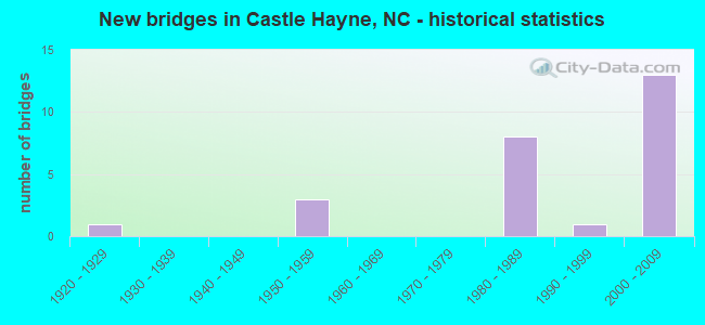
- New bridges - historical statistics
- 11920-1929
- 31950-1959
- 81980-1989
- 11990-1999
- 132000-2009
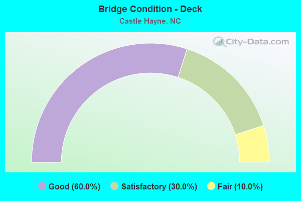
- Bridge Condition - Deck
- 60.0%Good
- 30.0%Satisfactory
- 10.0%Fair
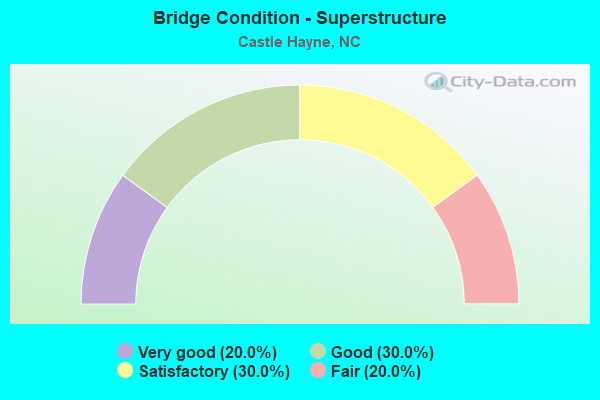
- Bridge Condition - Superstructure
- 20.0%Very good
- 30.0%Good
- 30.0%Satisfactory
- 20.0%Fair
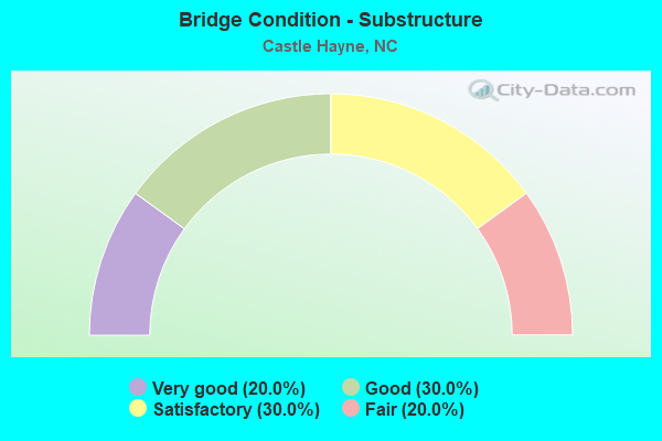
- Bridge Condition - Substructure
- 20.0%Very good
- 30.0%Good
- 30.0%Satisfactory
- 20.0%Fair
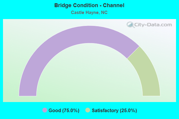
- Bridge Condition - Channel
- 75.0%Good
- 25.0%Satisfactory
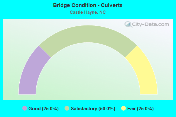
- Bridge Condition - Culverts
- 25.0%Good
- 50.0%Satisfactory
- 25.0%Fair
Find on map >> Show street view
Structure Number: 1290025, Location: 0.3 MI.E.JCT.NC132 (Lat: 34.329697, Lng: -77.881939), Route carried "on" structure: State highway 2103, Year Built: 1993, Status: Open, Structure Length: 0.76m (2.49ft), Average Daily Traffic: 210 (year 1992), Truck Traffic: 7%, Average Future Daily Traffic: 420 (year 2040), Design Load: HS 20+Mod, Features Intersected: BR.PRINCE GEORGE CREEK
Minimum Vertical Clearance: 30+ m (98+ ft), Kilometerpoint: 0.000, Lanes on structure: 2, Owner: State Highway Agency, Approaching Roadway Width: 5.4m (17.7ft), Material/Design: Concrete continuous, Design/Construction: Culvert, Number Of Spans In Main Unit: 2, Length of Maximum Span: 3.6m (11.8ft)
Condition: Channel: Good, Culverts: Good, Operating Rating: 41.7 metric tons, Method Used To Determine Operating Rating: Field evaluation and documented engineering judgment, Inventory Rating: 32.6 metric tons, Method Used To Determine Inventory Rating: Field evaluation and documented engineering judgment, Structural Evaluation: Better than present minimum criteria, Waterway Adequacy: Better than present minimum criteria, Approach Roadway Alignment: Equal to present desirable criteria, Designated Inspection Frequency: Every 24 months, Inspection Date: December 2020
Find on map >> Show street view
Structure Number: 1290031, Location: 1.2 MI. N. JCT. SR1340 (Lat: 34.364525, Lng: -77.897644), Route carried "on" structure: US 117, Year Built: 1951, Status: Open, Structure Length: 14.69m (48.20ft), Average Daily Traffic: 14,500 (year 2019), Truck Traffic: 6%, Average Future Daily Traffic: 29,000 (year 2040), Design Load: HS 15, Features Intersected: NE. CAPE FEAR RIVER
Minimum Vertical Clearance: 30+ m (98+ ft), Kilometerpoint: 0.000, Lanes on structure: 2, Owner: State Highway Agency, Approaching Roadway Width: 7.3m (24.0ft), Skew: 2 degrees, Navigation Control: Yes ( Vertical Clearance: 0.7m (2.3ft), Horizontal Clearance: 2.3m (7.5ft)), Material/Design: Steel continuous, Design/Construction: Stringer/Multi-beam, Number Of Spans In Main Unit: 3, Number Of Approach Spans: 5, Length of Maximum Span: 32.0m (105.0ft), Curb or Sidewalk Widths: Left: 0.6m (2.0ft), Right: 0.6m (2.0ft), Curb-To-Curb Width: 8.5m (27.9ft), Out-to-Out Width: 10.4m (34.1ft)
Condition: Deck: Satisfactory, Superstructure: Fair, Substructure: Fair, Channel: Satisfactory, Operating Rating: 41.7 metric tons, Method Used To Determine Operating Rating: Load Factor (LF), Inventory Rating: 25.4 metric tons, Method Used To Determine Inventory Rating: Load Factor (LF), Structural Evaluation: Somewhat better than minimum adequacy, Deck Geometry: Meets minimum limits, Waterway Adequacy: Better than present minimum criteria, Approach Roadway Alignment: Equal to present desirable criteria, Designated Inspection Frequency: Every 24 months, Underwater Inspection Frequency: Every 60 months, Inspection Date: April 2021, Underwater Inspection Date: April 2021, Deck Structure Type: Concrete Cast-file-Place, Wearing Surface/Protective System: Wearing Surface: Bituminous
Find on map >> Show street view
Structure Number: 129004, Location: 0.2 MI.E.JCT.HART ST. (Lat: 34.198450, Lng: -77.935589), Route carried "on" structure: City street , Year Built: 1950, Status: Open, Structure Length: 0.70m (2.30ft), Average Daily Traffic: 2,000 (year 2013), Truck Traffic: 7%, Average Future Daily Traffic: 4,000 (year 2040), Design Load: HS 20, Features Intersected: GREENFIELD LAKE, Facility Carried by Structure: W.LAKESHORE DRIVE
Minimum Vertical Clearance: 30+ m (98+ ft), Kilometerpoint: 0.000, Lanes on structure: 2, Owner: City or Municipal Highway Agency, Approaching Roadway Width: 7.3m (24.0ft), Material/Design: Steel, Design/Construction: Culvert, Number Of Spans In Main Unit: 3, Length of Maximum Span: 2.1m (6.9ft)
Condition: Channel: Good, Culverts: Satisfactory, Operating Rating: 89.8 metric tons, Method Used To Determine Operating Rating: Load and Resistance Factor (LRFR), Inventory Rating: 89.8 metric tons, Method Used To Determine Inventory Rating: Load and Resistance Factor (LRFR), Structural Evaluation: Equal to present minimum criteria, Waterway Adequacy: Better than present minimum criteria, Approach Roadway Alignment: Equal to present desirable criteria, Designated Inspection Frequency: Every 24 months, Underwater Inspection Frequency: Every 60 months, Inspection Date: April 2020, Underwater Inspection Date: April 2020
Find on map >> Show street view
Structure Number: 1290044, Location: 6.3 MI. E. OF JCT NC 210 (Lat: 34.353086, Lng: -77.884831), Route carried "on" structure: Interstate 40, Year Built: 1984, Status: Open, Structure Length: 5.51m (18.08ft), Average Daily Traffic: 19,000 (year 2019), Truck Traffic: 16%, Average Future Daily Traffic: 38,000 (year 2040), Design Load: HS 20+Mod, Features Intersected: SR1002
Minimum Vertical Clearance: 30+ m (98+ ft), Kilometerpoint: 126.341, Lanes on structure: 3, Lanes under structure: 4, Base Highway Network: Yes (Inventory Route: 1, Subroute: 40), Owner: State Highway Agency, Approaching Roadway Width: 14.9m (48.9ft), Skew: 12 degrees, Material/Design: Steel, Design/Construction: Stringer/Multi-beam, Number Of Spans In Main Unit: 3, Length of Maximum Span: 32.9m (107.9ft), Curb-To-Curb Width: 14.6m (47.9ft), Out-to-Out Width: 15.3m (50.2ft)
Condition: Deck: Good, Superstructure: Very good, Substructure: Very good, Operating Rating: 89.8 metric tons, Method Used To Determine Operating Rating: Load Factor (LF), Inventory Rating: 58.0 metric tons, Method Used To Determine Inventory Rating: Load Factor (LF), Structural Evaluation: Equal to present desirable criteria, Deck Geometry: Meets minimum limits, Underclear: Meets minimum limits, Approach Roadway Alignment: Equal to present desirable criteria, Designated Inspection Frequency: Every 24 months, Inspection Date: November 2020, Deck Structure Type: Concrete Cast-file-Place, Wearing Surface/Protective System: Wearing Surface: Monolithic Concrete
Find on map >> Show street view
Structure Number: 1290045, Location: 6.3 MI. E. JCT. NC210 (Lat: 34.353092, Lng: -77.885125), Route carried "on" structure: Interstate 40, Year Built: 1984, Status: Open, Structure Length: 5.51m (18.08ft), Average Daily Traffic: 19,000 (year 2019), Truck Traffic: 23%, Average Future Daily Traffic: 38,000 (year 2040), Design Load: HS 20+Mod, Features Intersected: SR1002
Minimum Vertical Clearance: 30+ m (98+ ft), Kilometerpoint: 126.341, Lanes on structure: 3, Lanes under structure: 4, Base Highway Network: Yes (Inventory Route: 1, Subroute: 40), Owner: State Highway Agency, Approaching Roadway Width: 14.9m (48.9ft), Skew: 12 degrees, Material/Design: Steel, Design/Construction: Stringer/Multi-beam, Number Of Spans In Main Unit: 3, Length of Maximum Span: 32.6m (107.0ft), Curb-To-Curb Width: 14.6m (47.9ft), Out-to-Out Width: 15.4m (50.5ft)
Condition: Deck: Good, Superstructure: Good, Substructure: Good, Operating Rating: 89.8 metric tons, Method Used To Determine Operating Rating: Load Factor (LF), Inventory Rating: 58.0 metric tons, Method Used To Determine Inventory Rating: Load Factor (LF), Structural Evaluation: Better than present minimum criteria, Deck Geometry: Meets minimum limits, Underclear: High priority of corrective action, Approach Roadway Alignment: Equal to present desirable criteria, Designated Inspection Frequency: Every 24 months, Inspection Date: November 2020, Deck Structure Type: Concrete Cast-file-Place, Wearing Surface/Protective System: Wearing Surface: Monolithic Concrete
Find on map >> Show street view
Structure Number: 1290047, Location: 0.5 MI.W.SR1002 (Lat: 34.358194, Lng: -77.887383), Route carried "on" structure: Interstate 40, Year Built: 1984, Status: Open, Structure Length: 3.68m (12.07ft), Average Daily Traffic: 19,000 (year 2019), Truck Traffic: 16%, Average Future Daily Traffic: 38,000 (year 2040), Design Load: HS 20+Mod, Features Intersected: IDEAL CEMENT CO.RR
Minimum Vertical Clearance: 30+ m (98+ ft), Kilometerpoint: 126.188, Lanes on structure: 2, Base Highway Network: Yes (Inventory Route: 1, Subroute: 40), Owner: State Highway Agency, Approaching Roadway Width: 13.1m (43.0ft), Skew: 10 degrees, Material/Design: Prestressed concrete, Design/Construction: Slab, Number Of Spans In Main Unit: 3, Length of Maximum Span: 11.8m (38.7ft), Curb-To-Curb Width: 12.8m (42.0ft), Out-to-Out Width: 13.7m (44.9ft)
Condition: Deck: Satisfactory, Superstructure: Satisfactory, Substructure: Satisfactory, Operating Rating: 62.5 metric tons, Method Used To Determine Operating Rating: Load Factor (LF), Inventory Rating: 37.1 metric tons, Method Used To Determine Inventory Rating: Load Factor (LF), Structural Evaluation: Equal to present minimum criteria, Deck Geometry: Equal to present desirable criteria, Underclear: Somewhat better than minimum adequacy, Approach Roadway Alignment: Equal to present desirable criteria, Designated Inspection Frequency: Every 24 months, Inspection Date: November 2020, Deck Structure Type: Concrete Precast Panels, Wearing Surface/Protective System: Wearing Surface: Bituminous
Find on map >> Show street view
Structure Number: 1290048, Location: 1.0 MI. W. JCT. SR1002 (Lat: 34.364139, Lng: -77.888194), Route carried "on" structure: Interstate 40, Year Built: 1984, Status: Open, Structure Length: 34.96m (114.70ft), Average Daily Traffic: 15,750 (year 2019), Truck Traffic: 16%, Average Future Daily Traffic: 31,500 (year 2040), Design Load: HS 20+Mod, Features Intersected: NORTHEAST CAPE FEAR RIVE
Minimum Vertical Clearance: 30+ m (98+ ft), Kilometerpoint: 126.036, Lanes on structure: 2, Base Highway Network: Yes (Inventory Route: 1, Subroute: 40), Owner: State Highway Agency, Approaching Roadway Width: 11.2m (36.7ft), Skew: 10 degrees, Navigation Control: Yes ( Vertical Clearance: 0.8m (2.6ft), Horizontal Clearance: 2.1m (6.9ft)), Material/Design: Prestressed concrete, Design/Construction: Stringer/Multi-beam, Number Of Spans In Main Unit: 13, Length of Maximum Span: 39.6m (129.9ft), Curb-To-Curb Width: 10.9m (35.8ft), Out-to-Out Width: 11.8m (38.7ft)
Condition: Deck: Good, Superstructure: Satisfactory, Substructure: Satisfactory, Channel: Good, Operating Rating: 89.8 metric tons, Method Used To Determine Operating Rating: Load Factor (LF), Inventory Rating: 45.3 metric tons, Method Used To Determine Inventory Rating: Load Factor (LF), Structural Evaluation: Equal to present minimum criteria, Deck Geometry: Meets minimum limits, Waterway Adequacy: Better than present minimum criteria, Approach Roadway Alignment: Equal to present desirable criteria, Designated Inspection Frequency: Every 24 months, Underwater Inspection Frequency: Every 60 months, Inspection Date: April 2021, Underwater Inspection Date: July 2019, Deck Structure Type: Concrete Cast-file-Place, Wearing Surface/Protective System: Wearing Surface: Monolithic Concrete
Find on map >> Show street view
Structure Number: 1290049, Location: 1.0 MI. W. JCT. SR1002 (Lat: 34.364103, Lng: -77.888439), Route carried "on" structure: Interstate 40, Year Built: 1984, Status: Open, Structure Length: 35.17m (115.39ft), Average Daily Traffic: 19,000 (year 2019), Truck Traffic: 16%, Average Future Daily Traffic: 38,000 (year 2040), Design Load: HS 20+Mod, Features Intersected: NE CAPE FEAR RIVER
Minimum Vertical Clearance: 30+ m (98+ ft), Kilometerpoint: 126.036, Lanes on structure: 2, Base Highway Network: Yes (Inventory Route: 1, Subroute: 40), Owner: State Highway Agency, Approaching Roadway Width: 11.2m (36.7ft), Skew: 10 degrees, Navigation Control: Yes ( Vertical Clearance: 8.8m (28.9ft), Horizontal Clearance: 21.3m (69.9ft)), Material/Design: Prestressed concrete, Design/Construction: Stringer/Multi-beam, Number Of Spans In Main Unit: 13, Length of Maximum Span: 39.6m (129.9ft), Curb-To-Curb Width: 10.9m (35.8ft), Out-to-Out Width: 11.8m (38.7ft)
Condition: Deck: Satisfactory, Superstructure: Satisfactory, Substructure: Satisfactory, Channel: Good, Operating Rating: 89.8 metric tons, Method Used To Determine Operating Rating: Load Factor (LF), Inventory Rating: 41.7 metric tons, Method Used To Determine Inventory Rating: Load Factor (LF), Structural Evaluation: Equal to present minimum criteria, Deck Geometry: Meets minimum limits, Waterway Adequacy: Better than present minimum criteria, Approach Roadway Alignment: Equal to present desirable criteria, Designated Inspection Frequency: Every 24 months, Underwater Inspection Frequency: Every 60 months, Inspection Date: April 2021, Underwater Inspection Date: July 2019, Deck Structure Type: Concrete Cast-file-Place, Wearing Surface/Protective System: Wearing Surface: Integral Concrete
Find on map >> Show street view
Structure Number: 129006, Location: 0.3 MI.N. OF JCT.SR2048 (Lat: 34.280461, Lng: -77.866150), Route carried "on" structure: Ramp Interstate 40, Year Built: 1985, Status: Open, Structure Length: 1.73m (5.68ft), Average Daily Traffic: 18,833 (year 2018), Truck Traffic: 16%, Average Future Daily Traffic: 37,666 (year 2040), Design Load: HS 20+Mod, Features Intersected: SMITH CREEK
Minimum Vertical Clearance: 30+ m (98+ ft), Kilometerpoint: 0.000, Lanes on structure: 1, Owner: State Highway Agency, Approaching Roadway Width: 4.8m (15.7ft), Skew: 5 degrees, Material/Design: Concrete continuous, Design/Construction: Culvert, Number Of Spans In Main Unit: 3, Length of Maximum Span: 3.3m (10.8ft)
Condition: Channel: Satisfactory, Culverts: Satisfactory, Operating Rating: 89.8 metric tons, Method Used To Determine Operating Rating: Load Factor (LF), Inventory Rating: 62.5 metric tons, Method Used To Determine Inventory Rating: Load Factor (LF), Structural Evaluation: Equal to present minimum criteria, Waterway Adequacy: Better than present minimum criteria, Approach Roadway Alignment: Equal to present desirable criteria, Designated Inspection Frequency: Every 24 months, Inspection Date: December 2020
Find on map >> Show street view
Structure Number: 1290064, Location: 1.1 MI.S OF JCT.US117 (Lat: 34.338883, Lng: -77.893358), Route carried "on" structure: US 117, Year Built: 1950, Status: Open, Structure Length: 0.94m (3.08ft), Average Daily Traffic: 11,000 (year 2017), Truck Traffic: 12%, Average Future Daily Traffic: 22,000 (year 2040), Design Load: HS 20, Features Intersected: PRINCE GEORGE CK.
Minimum Vertical Clearance: 30+ m (98+ ft), Kilometerpoint: 0.000, Lanes on structure: 2, Base Highway Network: Yes, Owner: State Highway Agency, Approaching Roadway Width: 7.3m (24.0ft), Skew: 2 degrees, Material/Design: Concrete continuous, Design/Construction: Culvert, Number Of Spans In Main Unit: 2, Length of Maximum Span: 4.2m (13.8ft)
Condition: Channel: Good, Culverts: Fair, Operating Rating: 41.7 metric tons, Method Used To Determine Operating Rating: Field evaluation and documented engineering judgment, Inventory Rating: 32.6 metric tons, Method Used To Determine Inventory Rating: Field evaluation and documented engineering judgment, Structural Evaluation: Somewhat better than minimum adequacy, Waterway Adequacy: Somewhat better than minimum adequacy, Approach Roadway Alignment: Equal to present desirable criteria, Designated Inspection Frequency: Every 24 months, Underwater Inspection Frequency: Every 60 months, Inspection Date: January 2021, Underwater Inspection Date: January 2021
Find on map >> Show street view
Structure Number: 1290096, Location: 4.0 MI. S. JCT. US17 (Lat: 34.318778, Lng: -77.871839), Route carried "on" structure: Interstate 140, Year Built: 2004, Status: Open, Structure Length: 8.38m (27.49ft), Average Daily Traffic: 13,250 (year 2018), Truck Traffic: 16%, Average Future Daily Traffic: 26,500 (year 2040), Design Load: HS 20+Mod, Features Intersected: I40
Minimum Vertical Clearance: 30+ m (98+ ft), Kilometerpoint: 0.000, Lanes on structure: 2, Lanes under structure: 7, Base Highway Network: Yes (Inventory Route: 1, Subroute: 40), Owner: State Highway Agency, Approaching Roadway Width: 11.2m (36.7ft), Skew: 10 degrees, Material/Design: Steel continuous, Design/Construction: Stringer/Multi-beam, Number Of Spans In Main Unit: 3, Length of Maximum Span: 32.0m (105.0ft), Curb-To-Curb Width: 11.2m (36.7ft), Out-to-Out Width: 12.1m (39.7ft)
Condition: Deck: Good, Superstructure: Good, Substructure: Good, Operating Rating: 89.8 metric tons, Method Used To Determine Operating Rating: Load Factor (LF), Inventory Rating: 55.3 metric tons, Method Used To Determine Inventory Rating: Load Factor (LF), Structural Evaluation: Better than present minimum criteria, Deck Geometry: Somewhat better than minimum adequacy, Underclear: Equal to present minimum criteria, Approach Roadway Alignment: Equal to present desirable criteria, Designated Inspection Frequency: Every 24 months, Inspection Date: January 2021, Deck Structure Type: Concrete Cast-file-Place, Wearing Surface/Protective System: Wearing Surface: Monolithic Concrete, Deck Protection: Epoxy Coated Reinforcing
Find on map >> Show street view
Structure Number: 1290097, Location: 5 MI. S. JCT. US 17 (Lat: 34.318964, Lng: -77.871856), Route carried "on" structure: Interstate 140, Year Built: 2004, Status: Open, Structure Length: 8.38m (27.49ft), Average Daily Traffic: 18,750 (year 2019), Truck Traffic: 16%, Average Future Daily Traffic: 37,500 (year 2040), Design Load: HS 20+Mod, Features Intersected: I40
Minimum Vertical Clearance: 30+ m (98+ ft), Kilometerpoint: 17.983, Lanes on structure: 3, Lanes under structure: 7, Base Highway Network: Yes (Inventory Route: 1, Subroute: 40), Owner: State Highway Agency, Approaching Roadway Width: 13.4m (44.0ft), Skew: 10 degrees, Material/Design: Steel continuous, Design/Construction: Stringer/Multi-beam, Number Of Spans In Main Unit: 3, Length of Maximum Span: 32.3m (106.0ft), Curb-To-Curb Width: 13.4m (44.0ft), Out-to-Out Width: 14.4m (47.2ft)
Condition: Deck: Good, Superstructure: Very good, Substructure: Good, Operating Rating: 87.0 metric tons, Method Used To Determine Operating Rating: Load Factor (LF), Inventory Rating: 51.7 metric tons, Method Used To Determine Inventory Rating: Load Factor (LF), Structural Evaluation: Better than present minimum criteria, Deck Geometry: High priority of corrective action, Underclear: Somewhat better than minimum adequacy, Approach Roadway Alignment: Equal to present minimum criteria, Designated Inspection Frequency: Every 24 months, Inspection Date: January 2021, Deck Structure Type: Concrete Cast-file-Place, Wearing Surface/Protective System: Wearing Surface: Monolithic Concrete, Deck Protection: Epoxy Coated Reinforcing
Find on map >> Show street view
Structure Number: 1290123, Location: 3.5MI.S.JCT.NC132 (Lat: 34.310006, Lng: -77.899964), Route carried "on" structure: Interstate 140, Year Built: 2005, Status: Open, Structure Length: 5.27m (17.29ft), Average Daily Traffic: 13,250 (year 2018), Truck Traffic: 16%, Average Future Daily Traffic: 26,500 (year 2040), Design Load: HS 20+Mod, Features Intersected: SR1318
Minimum Vertical Clearance: 30+ m (98+ ft), Kilometerpoint: 5.638, Lanes on structure: 2, Lanes under structure: 2, Base Highway Network: Yes (Inventory Route: 1, Subroute: 40), Owner: State Highway Agency, Approaching Roadway Width: 11.2m (36.7ft), Skew: 12 degrees, Material/Design: Prestressed concrete continuous, Design/Construction: Stringer/Multi-beam, Number Of Spans In Main Unit: 3, Length of Maximum Span: 28.3m (92.8ft), Curb-To-Curb Width: 11.1m (36.4ft), Out-to-Out Width: 12.2m (40.0ft)
Condition: Deck: Good, Superstructure: Good, Substructure: Very good, Operating Rating: 89.8 metric tons, Method Used To Determine Operating Rating: Load Factor (LF), Inventory Rating: 46.2 metric tons, Method Used To Determine Inventory Rating: Load Factor (LF), Structural Evaluation: Better than present minimum criteria, Deck Geometry: Somewhat better than minimum adequacy, Underclear: Superior to present desirable criteria, Approach Roadway Alignment: Equal to present desirable criteria, Designated Inspection Frequency: Every 24 months, Inspection Date: January 2021, Deck Structure Type: Concrete Cast-file-Place, Wearing Surface/Protective System: Wearing Surface: Monolithic Concrete, Deck Protection: Epoxy Coated Reinforcing
Find on map >> Show street view
Structure Number: 1410014, Location: .4 MI. N. OF SR1437 (Lat: 34.397472, Lng: -77.913028), Route carried "on" structure: State highway 133, Year Built: 1920, Year Reconstructed: 1956, Status: Open, Structure Length: 1.55m (5.09ft), Average Daily Traffic: 11,000 (year 2019), Truck Traffic: 6%, Average Future Daily Traffic: 22,000 (year 2040), Design Load: HS 15, Features Intersected: TURKEY CREEK
Minimum Vertical Clearance: 30+ m (98+ ft), Kilometerpoint: 0.000, Lanes on structure: 2, Owner: State Highway Agency, Approaching Roadway Width: 8.5m (27.9ft), Material/Design: Concrete, Design/Construction: Slab, Number Of Spans In Main Unit: 2, Length of Maximum Span: 7.0m (23.0ft), Curb-To-Curb Width: 8.6m (28.2ft), Out-to-Out Width: 10.2m (33.5ft)
Condition: Deck: Fair, Superstructure: Fair, Substructure: Fair, Channel: Good, Operating Rating: 50.8 metric tons, Method Used To Determine Operating Rating: Load Factor (LF), Inventory Rating: 30.8 metric tons, Method Used To Determine Inventory Rating: Load Factor (LF), Structural Evaluation: Somewhat better than minimum adequacy, Deck Geometry: High priority of replacement, Waterway Adequacy: Equal to present minimum criteria, Approach Roadway Alignment: Equal to present desirable criteria, Designated Inspection Frequency: Every 24 months, Underwater Inspection Frequency: Every 60 months, Inspection Date: October 2020, Underwater Inspection Date: December 2018, Deck Structure Type: Concrete Cast-file-Place, Wearing Surface/Protective System: Wearing Surface: Bituminous
Find on map >> Show street view
Structure Number: 1290044, Location: 6.3 MI. E. OF JCT NC 210 (Lat: 34.353086, Lng: -77.884831), Route carried "under" structure: State highway 1002, Year Built: 1984, Structure Length: 0. m, Average Daily Traffic: 11,000 (year 2019), Truck Traffic: 7%, Features Intersected: I40 WBL
Minimum Vertical Clearance: 6.19m (20.31ft), Kilometerpoint: 0.000, Lanes on structure: 3, Lanes under structure: 4, Material/Design: Steel, Design/Construction: Stringer/Multi-beam, Length of Maximum Span: 32.9m (107.9ft)
Find on map >> Show street view
Structure Number: 1290045, Location: 6.3 MI. E. JCT. NC210 (Lat: 34.353092, Lng: -77.885125), Route carried "under" structure: State highway 1002, Year Built: 1984, Structure Length: 0. m, Average Daily Traffic: 11,000 (year 2019), Truck Traffic: 14%, Features Intersected: I40E
Minimum Vertical Clearance: 6.07m (19.91ft), Kilometerpoint: 0.000, Lanes on structure: 3, Lanes under structure: 4, Material/Design: Steel, Design/Construction: Stringer/Multi-beam, Length of Maximum Span: 32.6m (107.0ft)
Find on map >> Show street view
Structure Number: 1290095, Location: 4.0 MI. S. JCT. US17 (Lat: 34.318569, Lng: -77.871822), Route carried "under" structure: Interstate 40, Year Built: 2004, Structure Length: 0. m, Average Daily Traffic: 17,500 (year 2017), Truck Traffic: 16%, Features Intersected: I140S COL,US17S
Minimum Vertical Clearance: 5.61m (18.41ft), Kilometerpoint: 126.798, Lanes on structure: 1, Lanes under structure: 2, Material/Design: Steel continuous, Design/Construction: Stringer/Multi-beam, Length of Maximum Span: 32.0m (105.0ft)
Find on map >> Show street view
Structure Number: 1290095, Location: 4.0 MI. S. JCT. US17 (Lat: 34.318569, Lng: -77.871822), Route carried "under" structure: Ramp Interstate 40, Year Built: 2004, Structure Length: 0. m, Average Daily Traffic: 17,500 (year 2017), Truck Traffic: 16%, Features Intersected: I140S COL,US17S
Minimum Vertical Clearance: 5.48m (17.98ft), Kilometerpoint: 126.798, Lanes on structure: 1, Lanes under structure: 2, Material/Design: Steel continuous, Design/Construction: Stringer/Multi-beam, Length of Maximum Span: 32.0m (105.0ft)
Find on map >> Show street view
Structure Number: 1290095, Location: 4.0 MI. S. JCT. US17 (Lat: 34.318569, Lng: -77.871822), Route carried "under" structure: Ramp Interstate 40, Year Built: 2004, Structure Length: 0. m, Average Daily Traffic: 17,500 (year 2017), Truck Traffic: 16%, Features Intersected: I140S COL,US17S
Minimum Vertical Clearance: 5.99m (19.65ft), Kilometerpoint: 126.798, Lanes on structure: 1, Lanes under structure: 3, Material/Design: Steel continuous, Design/Construction: Stringer/Multi-beam, Length of Maximum Span: 32.0m (105.0ft)
Find on map >> Show street view
Structure Number: 1290096, Location: 4.0 MI. S. JCT. US17 (Lat: 34.318778, Lng: -77.871839), Route carried "under" structure: Ramp Interstate 40, Year Built: 2004, Structure Length: 0. m, Average Daily Traffic: 17,500 (year 2017), Truck Traffic: 16%, Features Intersected: I140S, US17S
Minimum Vertical Clearance: 5.99m (19.65ft), Kilometerpoint: 126.798, Lanes on structure: 2, Lanes under structure: 3, Material/Design: Steel continuous, Design/Construction: Stringer/Multi-beam, Length of Maximum Span: 32.0m (105.0ft)
Find on map >> Show street view
Structure Number: 1290096, Location: 4.0 MI. S. JCT. US17 (Lat: 34.318778, Lng: -77.871839), Route carried "under" structure: Ramp Interstate 40, Year Built: 2004, Structure Length: 0. m, Average Daily Traffic: 17,500 (year 2017), Truck Traffic: 16%, Features Intersected: I140S, US17S
Minimum Vertical Clearance: 5.51m (18.08ft), Kilometerpoint: 126.798, Lanes on structure: 2, Lanes under structure: 2, Material/Design: Steel continuous, Design/Construction: Stringer/Multi-beam, Length of Maximum Span: 32.0m (105.0ft)
Find on map >> Show street view
Structure Number: 1290096, Location: 4.0 MI. S. JCT. US17 (Lat: 34.318778, Lng: -77.871839), Route carried "under" structure: Interstate 40, Year Built: 2004, Structure Length: 0. m, Average Daily Traffic: 17,500 (year 2017), Truck Traffic: 16%, Features Intersected: I140S, US17S
Minimum Vertical Clearance: 5.68m (18.64ft), Kilometerpoint: 126.798, Lanes on structure: 2, Lanes under structure: 2, Material/Design: Steel continuous, Design/Construction: Stringer/Multi-beam, Length of Maximum Span: 32.0m (105.0ft)
Find on map >> Show street view
Structure Number: 1290097, Location: 5 MI. S. JCT. US 17 (Lat: 34.318964, Lng: -77.871856), Route carried "under" structure: Ramp Interstate 40, Year Built: 2004, Structure Length: 0. m, Average Daily Traffic: 15,500 (year 2015), Truck Traffic: 16%, Features Intersected: I140 EBL; US17
Minimum Vertical Clearance: 5.35m (17.55ft), Kilometerpoint: 126.798, Lanes on structure: 3, Lanes under structure: 2, Material/Design: Steel continuous, Design/Construction: Stringer/Multi-beam, Length of Maximum Span: 32.3m (106.0ft)
Find on map >> Show street view
Structure Number: 1290097, Location: 5 MI. S. JCT. US 17 (Lat: 34.318964, Lng: -77.871856), Route carried "under" structure: Ramp Interstate 40, Year Built: 2004, Structure Length: 0. m, Average Daily Traffic: 15,500 (year 2015), Truck Traffic: 16%, Features Intersected: I140 EBL; US17
Minimum Vertical Clearance: 5.89m (19.32ft), Kilometerpoint: 126.798, Lanes on structure: 3, Lanes under structure: 3, Material/Design: Steel continuous, Design/Construction: Stringer/Multi-beam, Length of Maximum Span: 32.3m (106.0ft)
Find on map >> Show street view
Structure Number: 1290097, Location: 5 MI. S. JCT. US 17 (Lat: 34.318964, Lng: -77.871856), Route carried "under" structure: Interstate 40, Year Built: 2004, Structure Length: 0. m, Average Daily Traffic: 15,500 (year 2015), Truck Traffic: 16%, Features Intersected: I140 EBL; US17
Minimum Vertical Clearance: 5.53m (18.14ft), Kilometerpoint: 126.798, Lanes on structure: 3, Lanes under structure: 2, Material/Design: Steel continuous, Design/Construction: Stringer/Multi-beam, Length of Maximum Span: 32.3m (106.0ft)
Find on map >> Show street view
Structure Number: 1290123, Location: 3.5MI.S.JCT.NC132 (Lat: 34.310006, Lng: -77.899964), Route carried "under" structure: State highway 1318, Year Built: 2005, Structure Length: 0. m, Average Daily Traffic: 5,200 (year 2019), Truck Traffic: 6%, Features Intersected: I140 EBL,US17 NBL
Minimum Vertical Clearance: 5.35m (17.55ft), Kilometerpoint: 0.000, Lanes on structure: 2, Lanes under structure: 2, Material/Design: Prestressed concrete continuous, Design/Construction: Stringer/Multi-beam, Length of Maximum Span: 28.3m (92.8ft)