Bridge Statistics for Center Line, Michigan (MI)
Condition, Traffic, Stress, Structural Evaluation, Project Costs
- National Bridge Inventory (NBI) Statistics
- 11Number of bridges
- 177ft / 54mTotal length
- $1,356,000Total costs
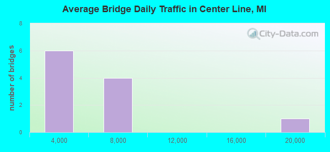
- 51,233Total average daily traffic
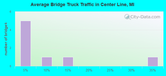
- 7,207Total average daily truck traffic
- 63,627Total future (year 1977) average daily traffic
- National Bridge Inventory (NBI) Registered Bridges for Center Line
- No street view available for this location
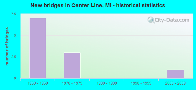
- New bridges - historical statistics
- 71960-1969
- 31970-1979
- 12000-2009
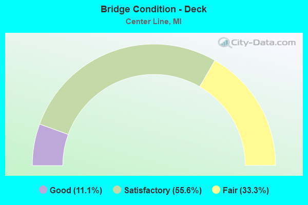
- Bridge Condition - Deck
- 11.1%Good
- 55.6%Satisfactory
- 33.3%Fair
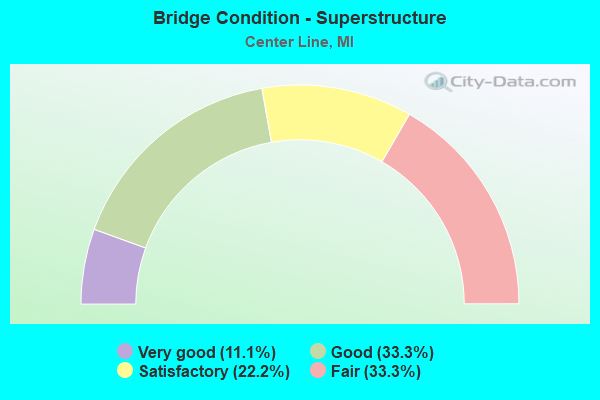
- Bridge Condition - Superstructure
- 11.1%Very good
- 33.3%Good
- 22.2%Satisfactory
- 33.3%Fair
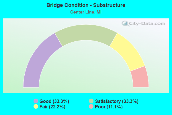
- Bridge Condition - Substructure
- 33.3%Good
- 33.3%Satisfactory
- 22.2%Fair
- 11.1%Poor
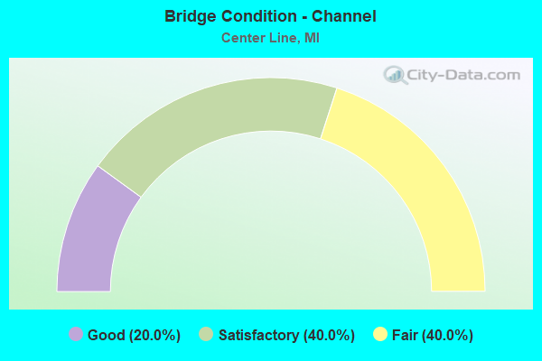
- Bridge Condition - Channel
- 20.0%Good
- 40.0%Satisfactory
- 40.0%Fair
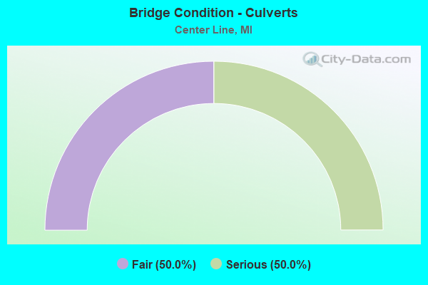
- Bridge Condition - Culverts
- 50.0%Fair
- 50.0%Serious
Find on map >> Show street view
Structure Number: 85, Location: 0.5 MI FROM M-28 OLD M-94 (Lat: 46.409053, Lng: -86.640403), Route carried "on" structure: City street 260, Year Built: 1978, Status: Open, Structure Length: 1.18m (3.87ft), Average Daily Traffic: 5,715 (year 1991), Truck Traffic: 10%, Average Future Daily Traffic: 8,650 (year 2011), Design Load: HS 20+Mod, Features Intersected: ANNA RIVER, Facility Carried by Structure: EAST MUNISING AVE
Minimum Vertical Clearance: 30.48m (100.00ft), Kilometerpoint: 43.933, Lanes on structure: 2, Owner: City or Municipal Highway Agency, Approaching Roadway Width: 128.0m (419.9ft), Material/Design: Prestressed concrete, Design/Construction: Box Beam or Girders - Multiple, Number Of Spans In Main Unit: 1, Length of Maximum Span: 10.9m (35.8ft), Curb or Sidewalk Widths: Left: 0.1m (0.3ft), Right: 0.1m (0.3ft), Curb-To-Curb Width: 7.3m (24.0ft), Out-to-Out Width: 10.9m (35.8ft)
Condition: Deck: Fair, Superstructure: Good, Substructure: Satisfactory, Channel: Satisfactory, Operating Rating: 79.4 metric tons, Method Used To Determine Operating Rating: Load Factor (LF) rating reported by rating factor (RF) method using MS18 loading, Inventory Rating: 47.6 metric tons, Method Used To Determine Inventory Rating: Load Factor (LF) rating reported by rating factor (RF) method using MS18 loading, Structural Evaluation: Equal to present minimum criteria, Deck Geometry: High priority of replacement, Waterway Adequacy: Equal to present desirable criteria, Approach Roadway Alignment: Equal to present desirable criteria, Designated Inspection Frequency: Every 24 months, Inspection Date: April 2016, Deck Structure Type: Concrete Precast Panels, Wearing Surface/Protective System: Wearing Surface: Bituminous, Membrane: Preformed Fabric
Find on map >> Show street view
Structure Number: 791, Location: 1.0 MI N OF HARBERT (Lat: 41.879908, Lng: -86.601686), Route carried "on" structure: Interstate 94, Year Built: 2003, Status: Open, Structure Length: 5.06m (16.60ft), Average Daily Traffic: 18,325 (year 2007), Truck Traffic: 32%, Average Future Daily Traffic: 25,023 (year 2018), Design Load: HS 25 or greater, Features Intersected: CSX RR
Minimum Vertical Clearance: 30.48m (100.00ft), Kilometerpoint: 18.703, Lanes on structure: 4, Base Highway Network: Yes (Inventory Route: 136, Subroute: 2), Owner: State Highway Agency, Approaching Roadway Width: 152.0m (498.7ft), Skew: 2 degrees, Material/Design: Prestressed concrete, Design/Construction: Box Beam or Girders - Single/Spread, Number Of Spans In Main Unit: 3, Length of Maximum Span: 17.2m (56.4ft), Curb-To-Curb Width: 22.6m (74.1ft), Out-to-Out Width: 23.5m (77.1ft)
Condition: Deck: Satisfactory, Superstructure: Very good, Substructure: Good, Operating Rating: 7.4 metric tons, Method Used To Determine Operating Rating: Load Factor (LF), Inventory Rating: 34.8 metric tons, Method Used To Determine Inventory Rating: Load Factor (LF), Structural Evaluation: Better than present minimum criteria, Deck Geometry: Superior to present desirable criteria, Underclear: Equal to present minimum criteria, Approach Roadway Alignment: Better than present minimum criteria, Designated Inspection Frequency: Every 24 months, Inspection Date: August 2016, Deck Structure Type: Concrete Cast-file-Place, Wearing Surface/Protective System: Wearing Surface: Epoxy Overlay, Deck Protection: Epoxy Coated Reinforcing
Find on map >> Show street view
Structure Number: 82, Location: 2.2 MI NE OF STEVENSVILLE (Lat: 42.043392, Lng: -86.497675), Route carried "on" structure: County highway 2013, Year Built: 1960, Status: Open, Structure Length: 10.41m (34.15ft), Average Daily Traffic: 5,865 (year 1992), Truck Traffic: 3%, Average Future Daily Traffic: 6,745 (year 2012), Design Load: H 15, Features Intersected: I-94, Facility Carried by Structure: GLENLORD ROAD
Minimum Vertical Clearance: 30.48m (100.00ft), Kilometerpoint: 2.472, Lanes on structure: 2, Lanes under structure: 6, Owner: State Highway Agency, Approaching Roadway Width: 87.0m (285.4ft), Skew: 4 degrees, Material/Design: Concrete continuous, Design/Construction: Tee Beam, Number Of Spans In Main Unit: 4, Length of Maximum Span: 29.5m (96.8ft), Curb or Sidewalk Widths: Left: 0.8m (2.6ft), Right: 0.8m (2.6ft), Curb-To-Curb Width: 7.9m (25.9ft), Out-to-Out Width: 10.2m (33.5ft)
Condition: Deck: Fair, Superstructure: Fair, Substructure: Fair, Operating Rating: 57.3 metric tons, Method Used To Determine Operating Rating: Load Factor (LF) rating reported by rating factor (RF) method using MS18 loading, Inventory Rating: 34.3 metric tons, Method Used To Determine Inventory Rating: Load Factor (LF) rating reported by rating factor (RF) method using MS18 loading, Structural Evaluation: Somewhat better than minimum adequacy, Deck Geometry: High priority of corrective action, Underclear: Equal to present minimum criteria, Approach Roadway Alignment: Equal to present minimum criteria, Length Of Structure Improvement: 104.30m (342.19ft), Designated Inspection Frequency: Every 24 months, Inspection Date: June 2016, Bridge Improvement Cost: $117,000, Roadway Improvement Cost: $12,000, Total Project Cost: $138,000, Deck Structure Type: Concrete Cast-file-Place, Wearing Surface/Protective System: Wearing Surface: Monolithic Concrete
Find on map >> Show street view
Structure Number: 8034, Location: 3.3 MI NW OF M-10 (Lat: 42.758564, Lng: -83.506347), Route carried "on" structure: County highway 6368, Year Built: 1962, Status: Open, Structure Length: 8.96m (29.40ft), Average Daily Traffic: 3,900 (year 1974), Truck Traffic: 3%, Average Future Daily Traffic: 3,900 (year 1977), Design Load: H 15, Features Intersected: I-75, Facility Carried by Structure: DAVISBURG RD
Minimum Vertical Clearance: 30.48m (100.00ft), Kilometerpoint: 10.609, Lanes on structure: 2, Lanes under structure: 6, Owner: State Highway Agency, Approaching Roadway Width: 97.0m (318.2ft), Skew: 3 degrees, Material/Design: Steel, Design/Construction: Stringer/Multi-beam, Number Of Spans In Main Unit: 5, Length of Maximum Span: 22.5m (73.8ft), Curb or Sidewalk Widths: Left: 0.7m (2.3ft), Right: 0.7m (2.3ft), Curb-To-Curb Width: 8.5m (27.9ft), Out-to-Out Width: 10.6m (34.8ft)
Condition: Deck: Satisfactory, Superstructure: Satisfactory, Substructure: Satisfactory, Operating Rating: 58.6 metric tons, Method Used To Determine Operating Rating: Load Factor (LF) rating reported by rating factor (RF) method using MS18 loading, Inventory Rating: 30.8 metric tons, Method Used To Determine Inventory Rating: Load Factor (LF) rating reported by rating factor (RF) method using MS18 loading, Structural Evaluation: Equal to present minimum criteria, Deck Geometry: Meets minimum limits, Underclear: Meets minimum limits, Approach Roadway Alignment: Equal to present desirable criteria, Designated Inspection Frequency: Every 24 months, Inspection Date: July 2017, Deck Structure Type: Concrete Cast-file-Place, Wearing Surface/Protective System: Wearing Surface: Latex Concrete
Find on map >> Show street view
Structure Number: 8035, Location: 4.8 MI NW OF M-10 (Lat: 42.772800, Lng: -83.523786), Route carried "on" structure: County highway , Year Built: 1963, Status: Open, Structure Length: 8.59m (28.18ft), Average Daily Traffic: 1,420 (year 1974), Truck Traffic: 3%, Average Future Daily Traffic: 1,420 (year 1977), Design Load: H 15, Features Intersected: I-75, Facility Carried by Structure: RATTALEE LAKE RD
Minimum Vertical Clearance: 30.48m (100.00ft), Kilometerpoint: 11.023, Lanes on structure: 2, Lanes under structure: 6, Owner: State Highway Agency, Approaching Roadway Width: 91.0m (298.6ft), Skew: 4 degrees, Material/Design: Steel, Design/Construction: Stringer/Multi-beam, Number Of Spans In Main Unit: 4, Length of Maximum Span: 28.2m (92.5ft), Curb-To-Curb Width: 8.4m (27.6ft), Out-to-Out Width: 9.4m (30.8ft)
Condition: Deck: Satisfactory, Superstructure: Good, Substructure: Good, Operating Rating: 53.8 metric tons, Method Used To Determine Operating Rating: Load Factor (LF) rating reported by rating factor (RF) method using MS18 loading, Inventory Rating: 26.6 metric tons, Method Used To Determine Inventory Rating: Load Factor (LF) rating reported by rating factor (RF) method using MS18 loading, Structural Evaluation: Equal to present minimum criteria, Deck Geometry: Meets minimum limits, Underclear: Meets minimum limits, Approach Roadway Alignment: Equal to present desirable criteria, Length Of Structure Improvement: 0.86m (2.82ft), Designated Inspection Frequency: Every 24 months, Inspection Date: July 2017, Bridge Improvement Cost: $836,000, Roadway Improvement Cost: $73,000, Total Project Cost: $863,000, Deck Structure Type: Concrete Cast-file-Place, Wearing Surface/Protective System: Wearing Surface: Epoxy Overlay
Find on map >> Show street view
Structure Number: 8036, Location: 5.4 MI NW OF M-15 (Lat: 42.782150, Lng: -83.534492), Route carried "on" structure: County highway 6380, Year Built: 1962, Status: Open, Structure Length: 10.39m (34.09ft), Average Daily Traffic: 6,708 (year 2010), Truck Traffic: 3%, Average Future Daily Traffic: 7,379 (year 2025), Design Load: HS 20+Mod, Features Intersected: I-75, Facility Carried by Structure: EAST HOLLY RD
Minimum Vertical Clearance: 30.48m (100.00ft), Kilometerpoint: 6.743, Lanes on structure: 2, Lanes under structure: 8, Owner: State Highway Agency, Approaching Roadway Width: 109.0m (357.6ft), Skew: 4 degrees, Material/Design: Steel, Design/Construction: Stringer/Multi-beam, Number Of Spans In Main Unit: 4, Length of Maximum Span: 35.6m (116.8ft), Curb or Sidewalk Widths: Left: 0.7m (2.3ft), Right: 0.7m (2.3ft), Curb-To-Curb Width: 9.1m (29.9ft), Out-to-Out Width: 11.2m (36.7ft)
Condition: Deck: Satisfactory, Superstructure: Good, Substructure: Satisfactory, Operating Rating: 61.6 metric tons, Method Used To Determine Operating Rating: Load Factor (LF) rating reported by rating factor (RF) method using MS18 loading, Inventory Rating: 36.9 metric tons, Method Used To Determine Inventory Rating: Load Factor (LF) rating reported by rating factor (RF) method using MS18 loading, Structural Evaluation: Equal to present minimum criteria, Deck Geometry: Meets minimum limits, Underclear: Meets minimum limits, Approach Roadway Alignment: Equal to present desirable criteria, Length Of Structure Improvement: 1.04m (3.41ft), Designated Inspection Frequency: Every 24 months, Inspection Date: May 2017, Bridge Improvement Cost: $247,000, Roadway Improvement Cost: $13,000, Total Project Cost: $149,000, Deck Structure Type: Concrete Cast-file-Place, Wearing Surface/Protective System: Wearing Surface: Latex Concrete
Find on map >> Show street view
Structure Number: 8037, Location: 3.3 MI SE OF GENESEE COL (Lat: 42.815497, Lng: -83.569561), Route carried "on" structure: County highway 6388, Year Built: 1961, Status: Open, Structure Length: 7.22m (23.69ft), Average Daily Traffic: 7,410 (year 1974), Truck Traffic: 3%, Average Future Daily Traffic: 7,410 (year 1977), Design Load: HS 20+Mod, Features Intersected: I-75, Facility Carried by Structure: GRANGE HALL RD
Minimum Vertical Clearance: 30.48m (100.00ft), Kilometerpoint: 10.093, Lanes on structure: 2, Lanes under structure: 8, Base Highway Network: Yes (Inventory Route: 64, Subroute: 4), Owner: State Highway Agency, Approaching Roadway Width: 109.0m (357.6ft), Material/Design: Steel, Design/Construction: Stringer/Multi-beam, Number Of Spans In Main Unit: 4, Length of Maximum Span: 24.7m (81.0ft), Curb or Sidewalk Widths: Left: 0.7m (2.3ft), Right: 0.7m (2.3ft), Curb-To-Curb Width: 9.1m (29.9ft), Out-to-Out Width: 11.2m (36.7ft)
Condition: Deck: Satisfactory, Superstructure: Fair, Substructure: Fair, Operating Rating: 64.8 metric tons, Method Used To Determine Operating Rating: Load Factor (LF) rating reported by rating factor (RF) method using MS18 loading, Inventory Rating: 38.9 metric tons, Method Used To Determine Inventory Rating: Load Factor (LF) rating reported by rating factor (RF) method using MS18 loading, Structural Evaluation: Somewhat better than minimum adequacy, Deck Geometry: Meets minimum limits, Underclear: Somewhat better than minimum adequacy, Approach Roadway Alignment: Equal to present desirable criteria, Length Of Structure Improvement: 72.30m (237.20ft), Designated Inspection Frequency: Every 24 months, Inspection Date: July 2017, Bridge Improvement Cost: $235,000, Roadway Improvement Cost: $16,000, Total Project Cost: $188,000, Deck Structure Type: Concrete Cast-file-Place, Wearing Surface/Protective System: Wearing Surface: Latex Concrete
Find on map >> Show street view
Structure Number: 8197, Location: BET LEDGE AND PIKEWOOD (Lat: 42.593931, Lng: -83.539047), Route carried "on" structure: County highway , Year Built: 1966, Status: Open, Structure Length: 0.19m (0.62ft), Average Daily Traffic: 1,000 (year 1986), Average Future Daily Traffic: 1,500 (year 2010), Design Load: HS 20+Mod, Features Intersected: LAKE SHERWOOD, Facility Carried by Structure: LEDGEWOOD
Minimum Vertical Clearance: 30.48m (100.00ft), Kilometerpoint: 0.587, Lanes on structure: 2, Owner: County Highway Agency, Approaching Roadway Width: 79.0m (259.2ft), Material/Design: Prestressed concrete, Design/Construction: Box Beam or Girders - Multiple, Number Of Spans In Main Unit: 1, Length of Maximum Span: 17.6m (57.7ft), Curb or Sidewalk Widths: Left: 1.2m (3.9ft), Right: 1.2m (3.9ft), Curb-To-Curb Width: 7.9m (25.9ft), Out-to-Out Width: 1.1m (3.6ft)
Condition: Deck: Good, Superstructure: Fair, Substructure: Good, Channel: Good, Operating Rating: 5.8 metric tons, Method Used To Determine Operating Rating: Load Factor (LF), Inventory Rating: 43.8 metric tons, Method Used To Determine Inventory Rating: Load Factor (LF), Structural Evaluation: Somewhat better than minimum adequacy, Deck Geometry: Somewhat better than minimum adequacy, Waterway Adequacy: Equal to present desirable criteria, Approach Roadway Alignment: Equal to present desirable criteria, Designated Inspection Frequency: Every 24 months, Inspection Date: June 2016, Deck Structure Type: Concrete Cast-file-Place, Wearing Surface/Protective System: Wearing Surface: Bituminous
Find on map >> Show street view
Structure Number: 8199, Location: SOUTH OF KURTZ (Lat: 42.841706, Lng: -83.688578), Route carried "on" structure: County highway , Year Built: 1979, Status: Open, Structure Length: 0.82m (2.69ft), Average Daily Traffic: 304 (year 1997), Truck Traffic: 5%, Average Future Daily Traffic: 500 (year 2017), Design Load: HS 20+Mod, Features Intersected: SWARTZ CREEK, Facility Carried by Structure: GAGE RD
Minimum Vertical Clearance: 30.48m (100.00ft), Kilometerpoint: 0.055, Lanes on structure: 2, Owner: County Highway Agency, Approaching Roadway Width: 79.0m (259.2ft), Skew: 1 degrees, Material/Design: Steel, Design/Construction: Culvert, Number Of Spans In Main Unit: 2, Length of Maximum Span: 3.6m (11.8ft), Curb or Sidewalk Widths: Left: 0.9m (3.0ft), Right: 0.9m (3.0ft), Out-to-Out Width: 11.5m (37.7ft)
Condition: Channel: Satisfactory, Culverts: Fair, Operating Rating: 62.5 metric tons, Method Used To Determine Operating Rating: Load Factor (LF) rating reported by rating factor (RF) method using MS18 loading, Inventory Rating: 57.7 metric tons, Method Used To Determine Inventory Rating: Load Factor (LF) rating reported by rating factor (RF) method using MS18 loading, Structural Evaluation: Somewhat better than minimum adequacy, Waterway Adequacy: Equal to present desirable criteria, Approach Roadway Alignment: Equal to present minimum criteria, Designated Inspection Frequency: Every 24 months, Inspection Date: June 2016
Find on map >> Show street view
Structure Number: 8201, Location: SOUTH OF TRAVIS (Lat: 42.495133, Lng: -83.638775), Route carried "on" structure: County highway , Year Built: 1970, Status: Posted for load, Structure Length: 0.88m (2.89ft), Average Daily Traffic: 260 (year 1997), Average Future Daily Traffic: 500 (year 2017), Design Load: HS 20+Mod, Features Intersected: NOVI-LYON DRAIN, Facility Carried by Structure: MARTINDALE
Minimum Vertical Clearance: 30.48m (100.00ft), Kilometerpoint: 3.772, Lanes on structure: 2, Owner: County Highway Agency, Approaching Roadway Width: 61.0m (200.1ft), Material/Design: Steel, Design/Construction: Culvert, Number Of Spans In Main Unit: 2, Length of Maximum Span: 3.6m (11.8ft), Out-to-Out Width: 13.7m (44.9ft)
Condition: Channel: Fair, Culverts: Serious, Operating Rating: 17.5 metric tons, Method Used To Determine Operating Rating: Load Factor (LF) rating reported by rating factor (RF) method using MS18 loading, Inventory Rating: 10.7 metric tons, Method Used To Determine Inventory Rating: Load Factor (LF) rating reported by rating factor (RF) method using MS18 loading, Structural Evaluation: High priority of corrective action, Waterway Adequacy: Somewhat better than minimum adequacy, Approach Roadway Alignment: Equal to present desirable criteria, Bridge Posting: Required (Relationship of Operating Rating to Maximum Legal Load: > 39.9% below), Designated Inspection Frequency: Every 12 months, Inspection Date: June 2017
Find on map >> Show street view
Structure Number: 8206, Location: WEST OF ORION RD (Lat: 42.725028, Lng: -83.158558), Route carried "on" structure: County highway , Year Built: 1961, Status: Posted for load, Structure Length: 1.22m (4.00ft), Average Daily Traffic: 326 (year 1983), Average Future Daily Traffic: 600 (year 2010), Design Load: HS 20+Mod, Features Intersected: PAINT CREEK, Facility Carried by Structure: SILVER BELL
Minimum Vertical Clearance: 30.48m (100.00ft), Kilometerpoint: 10.777, Lanes on structure: 2, Owner: County Highway Agency, Approaching Roadway Width: 82.0m (269.0ft), Material/Design: Prestressed concrete, Design/Construction: Box Beam or Girders - Multiple, Number Of Spans In Main Unit: 1, Length of Maximum Span: 11.2m (36.7ft), Curb or Sidewalk Widths: Left: 0.8m (2.6ft), Right: 0.8m (2.6ft), Curb-To-Curb Width: 8.2m (26.9ft), Out-to-Out Width: 10.1m (33.1ft)
Condition: Deck: Fair, Superstructure: Satisfactory, Substructure: Poor, Channel: Fair, Operating Rating: 40.6 metric tons, Method Used To Determine Operating Rating: Load Factor (LF), Inventory Rating: 24.3 metric tons, Method Used To Determine Inventory Rating: Load Factor (LF), Structural Evaluation: Meets minimum limits, Deck Geometry: Somewhat better than minimum adequacy, Waterway Adequacy: Somewhat better than minimum adequacy, Approach Roadway Alignment: Equal to present desirable criteria, Bridge Posting: Required (Relationship of Operating Rating to Maximum Legal Load: 20.0 - 29.9% below), Length Of Structure Improvement: 18.30m (60.04ft), Designated Inspection Frequency: Every 12 months, Inspection Date: September 2017, Bridge Improvement Cost: $15,000, Roadway Improvement Cost: $2,000, Total Project Cost: $18,000, Deck Structure Type: Concrete Cast-file-Place, Wearing Surface/Protective System: Wearing Surface: Gravel