Bridge Statistics for Chubbuck, Idaho (ID)
Condition, Traffic, Stress, Structural Evaluation, Project Costs
- National Bridge Inventory (NBI) Statistics
- 23Number of bridges
- 190ft / 58.1mTotal length
- $16,596,000Total costs
- 300,900Total average daily traffic
- 37,956Total average daily truck traffic
- National Bridge Inventory (NBI) Registered Bridges for Chubbuck
- No street view available for this location
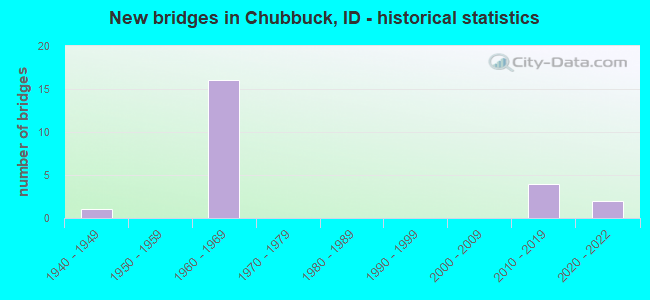
- New bridges - historical statistics
- 11940-1949
- 161960-1969
- 42010-2019
- 22020-2022
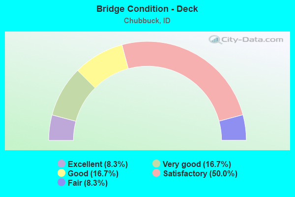
- Bridge Condition - Deck
- 8.3%Excellent
- 16.7%Very good
- 16.7%Good
- 50.0%Satisfactory
- 8.3%Fair
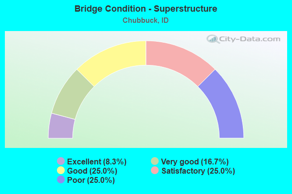
- Bridge Condition - Superstructure
- 8.3%Excellent
- 16.7%Very good
- 25.0%Good
- 25.0%Satisfactory
- 25.0%Poor
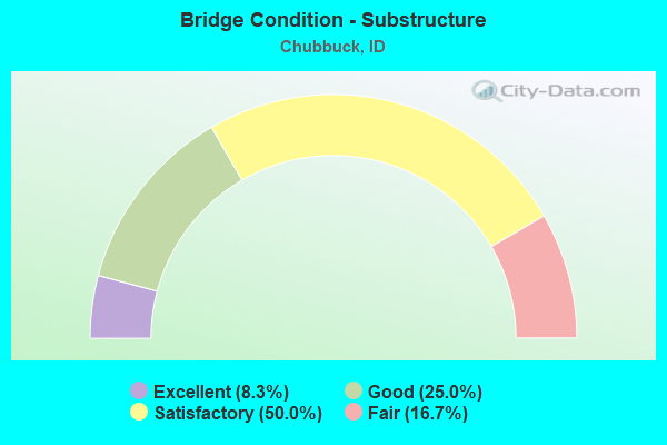
- Bridge Condition - Substructure
- 8.3%Excellent
- 25.0%Good
- 50.0%Satisfactory
- 16.7%Fair
Find on map >> Show street view
Structure Number: 10885, Location: IN CHUBBUCK (Lat: 42.912694, Lng: -112.476406), Route carried "on" structure: Interstate 86, Year Built: 1968, Status: Open, Structure Length: 3.75m (12.30ft), Average Daily Traffic: 6,500 (year 2019), Truck Traffic: 21%, Average Future Daily Traffic: 9,750 (year 2039), Design Load: HS 20, Features Intersected: SMA 7031;HAWTHORNE RD.GS
Minimum Vertical Clearance: 30+ m (98+ ft), Kilometerpoint: 97.785, Lanes on structure: 2, Lanes under structure: 2, Base Highway Network: Yes, Owner: State Highway Agency, Approaching Roadway Width: 11.9m (39.0ft), Material/Design: Prestressed concrete, Design/Construction: Stringer/Multi-beam, Number Of Spans In Main Unit: 3, Length of Maximum Span: 12.2m (40.0ft), Curb-To-Curb Width: 11.4m (37.4ft), Out-to-Out Width: 12.3m (40.4ft)
Condition: Deck: Good, Superstructure: Satisfactory, Substructure: Fair, Operating Rating: 55.3 metric tons, Method Used To Determine Operating Rating: Load Factor (LF), Inventory Rating: 32.7 metric tons, Method Used To Determine Inventory Rating: Load Factor (LF), Structural Evaluation: Somewhat better than minimum adequacy, Deck Geometry: Somewhat better than minimum adequacy, Underclear: High priority of replacement, Approach Roadway Alignment: Equal to present desirable criteria, Length Of Structure Improvement: 4.75m (15.58ft), Designated Inspection Frequency: Every 24 months, Inspection Date: August 2020, Bridge Improvement Cost: $1,080,000, Roadway Improvement Cost: $108,000, Total Project Cost: $1,620,000 ( Estimate for 2020), Deck Structure Type: Concrete Cast-file-Place, Wearing Surface/Protective System: Wearing Surface: Latex Concrete
Find on map >> Show street view
Structure Number: 1089, Location: IN CHUBBUCK (Lat: 42.913017, Lng: -112.475942), Route carried "on" structure: Interstate 86, Year Built: 1968, Status: Open, Structure Length: 3.75m (12.30ft), Average Daily Traffic: 6,500 (year 2019), Truck Traffic: 21%, Average Future Daily Traffic: 9,750 (year 2039), Design Load: HS 20, Features Intersected: SMA 7031;HAWTHORNE RD.GS
Minimum Vertical Clearance: 30+ m (98+ ft), Kilometerpoint: 97.787, Lanes on structure: 2, Lanes under structure: 2, Base Highway Network: Yes, Owner: State Highway Agency, Approaching Roadway Width: 11.9m (39.0ft), Material/Design: Prestressed concrete, Design/Construction: Stringer/Multi-beam, Number Of Spans In Main Unit: 3, Length of Maximum Span: 12.2m (40.0ft), Curb-To-Curb Width: 11.4m (37.4ft), Out-to-Out Width: 12.3m (40.4ft)
Condition: Deck: Satisfactory, Superstructure: Satisfactory, Substructure: Fair, Operating Rating: 55.3 metric tons, Method Used To Determine Operating Rating: Load Factor (LF), Inventory Rating: 32.7 metric tons, Method Used To Determine Inventory Rating: Load Factor (LF), Structural Evaluation: Somewhat better than minimum adequacy, Deck Geometry: Somewhat better than minimum adequacy, Underclear: High priority of replacement, Approach Roadway Alignment: Equal to present desirable criteria, Length Of Structure Improvement: 4.75m (15.58ft), Designated Inspection Frequency: Every 24 months, Inspection Date: August 2020, Bridge Improvement Cost: $1,080,000, Roadway Improvement Cost: $108,000, Total Project Cost: $1,620,000 ( Estimate for 2020), Deck Structure Type: Concrete Cast-file-Place, Wearing Surface/Protective System: Wearing Surface: Latex Concrete
Find on map >> Show street view
Structure Number: 10935, Location: 1.2 E. CHUBBUCK (Lat: 42.912833, Lng: -112.442972), Route carried "on" structure: Ramp Interstate 86, Year Built: 1963, Status: Open, Structure Length: 5.21m (17.09ft), Average Daily Traffic: 5,000 (year 2019), Average Future Daily Traffic: 7,500 (year 2039), Design Load: HS 20, Features Intersected: I 15 NB TO I 86 WB RAMP
Minimum Vertical Clearance: 30+ m (98+ ft), Kilometerpoint: 0.269, Lanes on structure: 1, Lanes under structure: 1, Owner: State Highway Agency, Approaching Roadway Width: 10.4m (34.1ft), Skew: 3 degrees, Material/Design: Prestressed concrete, Design/Construction: Stringer/Multi-beam, Number Of Spans In Main Unit: 3, Length of Maximum Span: 19.2m (63.0ft), Curb-To-Curb Width: 9.7m (31.8ft), Out-to-Out Width: 10.4m (34.1ft)
Condition: Deck: Satisfactory, Superstructure: Satisfactory, Substructure: Satisfactory, Operating Rating: 52.6 metric tons, Method Used To Determine Operating Rating: Load Factor (LF), Inventory Rating: 30.8 metric tons, Method Used To Determine Inventory Rating: Load Factor (LF), Structural Evaluation: Equal to present minimum criteria, Deck Geometry: Superior to present desirable criteria, Underclear: Better than present minimum criteria, Approach Roadway Alignment: Equal to present desirable criteria, Designated Inspection Frequency: Every 24 months, Inspection Date: August 2020, Deck Structure Type: Concrete Cast-file-Place, Wearing Surface/Protective System: Wearing Surface: Bituminous
Find on map >> Show street view
Structure Number: 1128, Location: 2.7 N. POCATELLO (Lat: 42.911778, Lng: -112.440806), Route carried "on" structure: Interstate 15, Year Built: 1962, Status: Open, Structure Length: 6.58m (21.59ft), Average Daily Traffic: 17,500 (year 2019), Truck Traffic: 17%, Average Future Daily Traffic: 26,250 (year 2039), Design Load: HS 20, Features Intersected: I 86 WB RAMP
Minimum Vertical Clearance: 30+ m (98+ ft), Kilometerpoint: 115.931, Lanes on structure: 2, Lanes under structure: 1, Base Highway Network: Yes, Owner: State Highway Agency, Approaching Roadway Width: 11.9m (39.0ft), Skew: 5 degrees, Material/Design: Prestressed concrete, Design/Construction: Stringer/Multi-beam, Number Of Spans In Main Unit: 3, Length of Maximum Span: 29.9m (98.1ft), Curb-To-Curb Width: 11.9m (39.0ft), Out-to-Out Width: 12.2m (40.0ft)
Condition: Deck: Fair, Superstructure: Poor, Substructure: Satisfactory, Operating Rating: 61.7 metric tons, Method Used To Determine Operating Rating: Load Factor (LF), Inventory Rating: 37.2 metric tons, Method Used To Determine Inventory Rating: Load Factor (LF), Structural Evaluation: Meets minimum limits, Deck Geometry: Equal to present minimum criteria, Underclear: Somewhat better than minimum adequacy, Approach Roadway Alignment: Equal to present desirable criteria, Length Of Structure Improvement: 7.56m (24.80ft), Designated Inspection Frequency: Every 12 months, Inspection Date: June 2021, Bridge Improvement Cost: $1,700,000, Roadway Improvement Cost: $170,000, Total Project Cost: $2,550,000 ( Estimate for 2016), Deck Structure Type: Concrete Cast-file-Place, Wearing Surface/Protective System: Wearing Surface: Bituminous
Find on map >> Show street view
Structure Number: 11285, Location: 2.9 N. POCATELLO (Lat: 42.913833, Lng: -112.441056), Route carried "on" structure: Interstate 15, Year Built: 1962, Status: Open, Structure Length: 6.98m (22.90ft), Average Daily Traffic: 17,500 (year 2019), Truck Traffic: 17%, Average Future Daily Traffic: 26,250 (year 2039), Design Load: HS 20, Features Intersected: I 86 EB RAMP
Minimum Vertical Clearance: 30+ m (98+ ft), Kilometerpoint: 116.167, Lanes on structure: 2, Lanes under structure: 1, Base Highway Network: Yes, Owner: State Highway Agency, Approaching Roadway Width: 11.9m (39.0ft), Skew: 5 degrees, Material/Design: Prestressed concrete, Design/Construction: Stringer/Multi-beam, Number Of Spans In Main Unit: 3, Length of Maximum Span: 29.9m (98.1ft), Curb-To-Curb Width: 11.9m (39.0ft), Out-to-Out Width: 12.2m (40.0ft)
Condition: Deck: Satisfactory, Superstructure: Poor, Substructure: Satisfactory, Operating Rating: 61.7 metric tons, Method Used To Determine Operating Rating: Load Factor (LF), Inventory Rating: 38.1 metric tons, Method Used To Determine Inventory Rating: Load Factor (LF), Structural Evaluation: Meets minimum limits, Deck Geometry: Equal to present minimum criteria, Underclear: Somewhat better than minimum adequacy, Approach Roadway Alignment: Equal to present desirable criteria, Length Of Structure Improvement: 8.02m (26.31ft), Designated Inspection Frequency: Every 12 months, Inspection Date: June 2021, Bridge Improvement Cost: $1,800,000, Roadway Improvement Cost: $180,000, Total Project Cost: $2,700,000 ( Estimate for 2016), Deck Structure Type: Concrete Cast-file-Place, Wearing Surface/Protective System: Wearing Surface: Bituminous
Find on map >> Show street view
Structure Number: 17496, Location: IN CHUBBUCK (Lat: 42.912514, Lng: -112.466525), Route carried "on" structure: US 91, Year Built: 2013, Status: Open, Structure Length: 5.24m (17.19ft), Average Daily Traffic: 11,500 (year 2019), Truck Traffic: 3%, Average Future Daily Traffic: 17,250 (year 2039), Design Load: HL 93, Features Intersected: I 86 EB-WB; CHUBBUCK IC
Minimum Vertical Clearance: 7.32m (24.02ft), Kilometerpoint: 128.814, Lanes on structure: 2, Lanes under structure: 4, Base Highway Network: Yes (Inventory Route: US0, Subroute: 1), Owner: State Highway Agency, Approaching Roadway Width: 12.2m (40.0ft), Material/Design: Steel continuous, Design/Construction: Stringer/Multi-beam, Number Of Spans In Main Unit: 2, Length of Maximum Span: 25.9m (85.0ft), Curb or Sidewalk Widths: Left: 0.0m, Right: 3.4m (11.2ft), Curb-To-Curb Width: 12.3m (40.4ft), Out-to-Out Width: 16.8m (55.1ft)
Condition: Deck: Very good, Superstructure: Very good, Substructure: Good, Operating Rating: 52.2 metric tons, Method Used To Determine Operating Rating: Load and Resistance Factor Rating (LRFR) rating reported by rating factor(RF) method using HL-93 loadings, Inventory Rating: 40.2 metric tons, Method Used To Determine Inventory Rating: Load and Resistance Factor Rating (LRFR) rating reported by rating factor(RF) method using HL-93 loadings, Structural Evaluation: Better than present minimum criteria, Deck Geometry: Better than present minimum criteria, Underclear: Equal to present minimum criteria, Approach Roadway Alignment: Equal to present desirable criteria, Designated Inspection Frequency: Every 48 months, Inspection Date: November 2021, Deck Structure Type: Concrete Cast-file-Place, Wearing Surface/Protective System: Wearing Surface: Epoxy Overlay, Deck Protection: Epoxy Coated Reinforcing
Find on map >> Show street view
Structure Number: 17498, Location: IN CHUBBUCK (Lat: 42.913100, Lng: -112.466144), Route carried "on" structure: US 91, Year Built: 2013, Status: Open, Structure Length: 5.24m (17.19ft), Average Daily Traffic: 11,500 (year 2019), Truck Traffic: 3%, Average Future Daily Traffic: 17,250 (year 2039), Design Load: HL 93, Features Intersected: I 86 EB-WB; CHUBBUCK IC
Minimum Vertical Clearance: 7.32m (24.02ft), Kilometerpoint: 128.606, Lanes on structure: 2, Lanes under structure: 4, Base Highway Network: Yes (Inventory Route: US0, Subroute: 1), Owner: State Highway Agency, Approaching Roadway Width: 12.2m (40.0ft), Material/Design: Steel continuous, Design/Construction: Stringer/Multi-beam, Number Of Spans In Main Unit: 2, Length of Maximum Span: 25.9m (85.0ft), Curb-To-Curb Width: 12.3m (40.4ft), Out-to-Out Width: 13.1m (43.0ft)
Condition: Deck: Very good, Superstructure: Very good, Substructure: Good, Operating Rating: 51.5 metric tons, Method Used To Determine Operating Rating: Load and Resistance Factor Rating (LRFR) rating reported by rating factor(RF) method using HL-93 loadings, Inventory Rating: 39.9 metric tons, Method Used To Determine Inventory Rating: Load and Resistance Factor Rating (LRFR) rating reported by rating factor(RF) method using HL-93 loadings, Structural Evaluation: Better than present minimum criteria, Deck Geometry: Better than present minimum criteria, Underclear: Equal to present minimum criteria, Approach Roadway Alignment: Equal to present desirable criteria, Designated Inspection Frequency: Every 48 months, Inspection Date: November 2021, Deck Structure Type: Concrete Cast-file-Place, Wearing Surface/Protective System: Wearing Surface: Epoxy Overlay, Deck Protection: Epoxy Coated Reinforcing
Find on map >> Show street view
Structure Number: 21215, Location: 3.2 N. POCATELLO (Lat: 42.920417, Lng: -112.442000), Route carried "on" structure: City street 7041, Year Built: 1962, Status: Open, Structure Length: 3.69m (12.11ft), Average Daily Traffic: 6,000 (year 2019), Truck Traffic: 7%, Average Future Daily Traffic: 9,000 (year 2039), Design Load: HS 20, Features Intersected: I 15 SB;CHUBBUCK RD.GS
Minimum Vertical Clearance: 30+ m (98+ ft), Kilometerpoint: 3.764, Lanes on structure: 2, Lanes under structure: 2, Base Highway Network: Yes, Owner: State Highway Agency, Approaching Roadway Width: 8.5m (27.9ft), Material/Design: Prestressed concrete, Design/Construction: Stringer/Multi-beam, Number Of Spans In Main Unit: 1, Number Of Approach Spans: 2, Length of Maximum Span: 16.8m (55.1ft), Curb or Sidewalk Widths: Left: 1.1m (3.6ft), Right: 1.1m (3.6ft), Curb-To-Curb Width: 8.6m (28.2ft), Out-to-Out Width: 11.5m (37.7ft)
Condition: Deck: Satisfactory, Superstructure: Good, Substructure: Satisfactory, Operating Rating: 77.1 metric tons, Method Used To Determine Operating Rating: Load Factor (LF), Inventory Rating: 36.3 metric tons, Method Used To Determine Inventory Rating: Load Factor (LF), Structural Evaluation: Equal to present minimum criteria, Deck Geometry: High priority of replacement, Underclear: Meets minimum limits, Approach Roadway Alignment: Equal to present desirable criteria, Length Of Structure Improvement: 4.60m (15.09ft), Designated Inspection Frequency: Every 48 months, Inspection Date: August 2021, Bridge Improvement Cost: $1,370,000, Roadway Improvement Cost: $137,000, Total Project Cost: $2,055,000 ( Estimate for 2017), Deck Structure Type: Concrete Cast-file-Place, Wearing Surface/Protective System: Wearing Surface: Latex Concrete
Find on map >> Show street view
Structure Number: 2122, Location: 3.2 N. POCATELLO (Lat: 42.920417, Lng: -112.440694), Route carried "on" structure: County highway 7041, Year Built: 1962, Status: Open, Structure Length: 4.30m (14.11ft), Average Daily Traffic: 6,000 (year 2019), Truck Traffic: 7%, Average Future Daily Traffic: 9,000 (year 2039), Design Load: HS 20, Features Intersected: I 15 NB;CHUBBUCK RD.GS
Minimum Vertical Clearance: 30+ m (98+ ft), Kilometerpoint: 3.869, Lanes on structure: 2, Lanes under structure: 2, Base Highway Network: Yes, Owner: State Highway Agency, Approaching Roadway Width: 10.4m (34.1ft), Material/Design: Prestressed concrete, Design/Construction: Stringer/Multi-beam, Number Of Spans In Main Unit: 2, Number Of Approach Spans: 1, Length of Maximum Span: 17.4m (57.1ft), Curb or Sidewalk Widths: Left: 1.1m (3.6ft), Right: 1.1m (3.6ft), Curb-To-Curb Width: 8.6m (28.2ft), Out-to-Out Width: 11.5m (37.7ft)
Condition: Deck: Satisfactory, Superstructure: Good, Substructure: Satisfactory, Operating Rating: 74.4 metric tons, Method Used To Determine Operating Rating: Load Factor (LF), Inventory Rating: 31.8 metric tons, Method Used To Determine Inventory Rating: Load Factor (LF), Structural Evaluation: Equal to present minimum criteria, Deck Geometry: High priority of replacement, Underclear: Somewhat better than minimum adequacy, Approach Roadway Alignment: Equal to present desirable criteria, Length Of Structure Improvement: 5.15m (16.90ft), Designated Inspection Frequency: Every 48 months, Inspection Date: August 2021, Bridge Improvement Cost: $1,534,000, Roadway Improvement Cost: $153,000, Total Project Cost: $2,301,000 ( Estimate for 2017), Deck Structure Type: Concrete Cast-file-Place, Wearing Surface/Protective System: Wearing Surface: Latex Concrete
Find on map >> Show street view
Structure Number: 21223, Location: 4.0 N POCATELLO (Lat: 42.932861, Lng: -112.440528), Route carried "on" structure: County highway , Year Built: 2020, Status: Open, Structure Length: 5.30m (17.39ft), Average Daily Traffic: 26,000 (year 2019), Truck Traffic: 17%, Average Future Daily Traffic: 39,000 (year 2039), Design Load: HL 93, Features Intersected: I 15 NB-SB: NORTHGATE IC, Facility Carried by Structure: NORTHGATE PARKWAY
Minimum Vertical Clearance: 30+ m (98+ ft), Kilometerpoint: 1.106, Lanes on structure: 7, Lanes under structure: 4, Base Highway Network: Yes, Owner: State Highway Agency, Approaching Roadway Width: 27.8m (91.2ft), Material/Design: Prestressed concrete, Design/Construction: Stringer/Multi-beam, Number Of Spans In Main Unit: 2, Length of Maximum Span: 25.9m (85.0ft), Curb or Sidewalk Widths: Left: 0.0m, Right: 4.3m (14.1ft), Curb-To-Curb Width: 27.8m (91.2ft), Out-to-Out Width: 33.2m (108.9ft)
Condition: Deck: Excellent, Superstructure: Excellent, Substructure: Excellent, Operating Rating: 58.3 metric tons, Method Used To Determine Operating Rating: Load and Resistance Factor Rating (LRFR) rating reported by rating factor(RF) method using HL-93 loadings, Inventory Rating: 41.8 metric tons, Method Used To Determine Inventory Rating: Load and Resistance Factor Rating (LRFR) rating reported by rating factor(RF) method using HL-93 loadings, Structural Evaluation: Superior to present desirable criteria, Deck Geometry: Somewhat better than minimum adequacy, Underclear: Equal to present minimum criteria, Approach Roadway Alignment: Equal to present desirable criteria, Designated Inspection Frequency: Every 24 months, Inspection Date: March 2020, Deck Structure Type: Concrete Cast-file-Place, Wearing Surface/Protective System: Wearing Surface: Monolithic Concrete, Deck Protection: Epoxy Coated Reinforcing
Find on map >> Show street view
Structure Number: 22015, Location: 1.8 N. 1.5 W.CHUBBUCK (Lat: 42.938083, Lng: -112.496222), Route carried "on" structure: County highway 7131, Year Built: 1949, Status: Open, Structure Length: 0.73m (2.40ft), Average Daily Traffic: 1,100 (year 2019), Truck Traffic: 15%, Average Future Daily Traffic: 1,650 (year 2039), Design Load: H 15, Features Intersected: TYHEE LATERAL CANAL, Facility Carried by Structure: STC1727;PHILBIN
Minimum Vertical Clearance: 30+ m (98+ ft), Kilometerpoint: 20.518, Lanes on structure: 2, Owner: County Highway Agency, Approaching Roadway Width: 7.9m (25.9ft), Skew: 4 degrees, Material/Design: Concrete, Design/Construction: Frame, Number Of Spans In Main Unit: 1, Length of Maximum Span: 7.3m (24.0ft), Curb-To-Curb Width: 9.9m (32.5ft), Out-to-Out Width: 10.7m (35.1ft)
Condition: Deck: Good, Superstructure: Good, Substructure: Good, Channel: Satisfactory, Operating Rating: 37.2 metric tons, Method Used To Determine Operating Rating: Load Factor (LF), Inventory Rating: 21.8 metric tons, Method Used To Determine Inventory Rating: Load Factor (LF), Structural Evaluation: Somewhat better than minimum adequacy, Deck Geometry: Somewhat better than minimum adequacy, Waterway Adequacy: Better than present minimum criteria, Approach Roadway Alignment: Equal to present desirable criteria, Designated Inspection Frequency: Every 24 months, Inspection Date: April 2021, Deck Structure Type: Concrete Cast-file-Place, Wearing Surface/Protective System: Wearing Surface: Bituminous
Find on map >> Show street view
Structure Number: 22105, Location: 1.5 W. CHUBBUCK (Lat: 42.912528, Lng: -112.495833), Route carried "on" structure: County highway , Year Built: 1968, Status: Open, Structure Length: 7.38m (24.21ft), Average Daily Traffic: 4,300 (year 2019), Truck Traffic: 4%, Average Future Daily Traffic: 6,450 (year 2039), Design Load: HS 20, Features Intersected: I 86 EB-WB;PHILBIN RD GS, Facility Carried by Structure: PHILBIN ROAD
Minimum Vertical Clearance: 30+ m (98+ ft), Kilometerpoint: 17.677, Lanes on structure: 2, Lanes under structure: 4, Owner: State Highway Agency, Approaching Roadway Width: 9.1m (29.9ft), Material/Design: Prestressed concrete, Design/Construction: Stringer/Multi-beam, Number Of Spans In Main Unit: 5, Length of Maximum Span: 15.2m (49.9ft), Curb or Sidewalk Widths: Left: 0.4m (1.3ft), Right: 0.4m (1.3ft), Curb-To-Curb Width: 8.5m (27.9ft), Out-to-Out Width: 10.2m (33.5ft)
Condition: Deck: Satisfactory, Superstructure: Poor, Substructure: Satisfactory, Operating Rating: 60.8 metric tons, Method Used To Determine Operating Rating: Load Factor (LF), Inventory Rating: 36.3 metric tons, Method Used To Determine Inventory Rating: Load Factor (LF), Structural Evaluation: Meets minimum limits, Deck Geometry: Meets minimum limits, Underclear: High priority of replacement, Approach Roadway Alignment: Equal to present desirable criteria, Length Of Structure Improvement: 8.41m (27.59ft), Designated Inspection Frequency: Every 12 months, Inspection Date: August 2021, Bridge Improvement Cost: $2,500,000, Roadway Improvement Cost: $250,000, Total Project Cost: $3,750,000 ( Estimate for 2018), Deck Structure Type: Concrete Cast-file-Place, Wearing Surface/Protective System: Wearing Surface: Epoxy Overlay
Find on map >> Show street view
Structure Number: 10885, Location: IN CHUBBUCK (Lat: 42.912694, Lng: -112.476406), Route carried "under" structure: County highway 7031, Year Built: 1968, Structure Length: 0. m, Average Daily Traffic: 10,000 (year 2018), Truck Traffic: 3%, Features Intersected: SMA 7031;HAWTHORNE RD.GS, Facility Carried by Structure: I 86 EBL
Minimum Vertical Clearance: 4.55m (14.93ft), Kilometerpoint: 2.454, Lanes on structure: 2, Lanes under structure: 2, Material/Design: Prestressed concrete, Design/Construction: Stringer/Multi-beam, Length of Maximum Span: 12.2m (40.0ft)
Find on map >> Show street view
Structure Number: 1089, Location: IN CHUBBUCK (Lat: 42.913017, Lng: -112.475942), Route carried "under" structure: County highway 7031, Year Built: 1968, Structure Length: 0. m, Average Daily Traffic: 10,000 (year 2018), Truck Traffic: 3%, Features Intersected: SMA 7031;HAWTHORNE RD.GS, Facility Carried by Structure: I 86 WBL
Minimum Vertical Clearance: 4.51m (14.80ft), Kilometerpoint: 2.486, Lanes on structure: 2, Lanes under structure: 2, Material/Design: Prestressed concrete, Design/Construction: Stringer/Multi-beam, Length of Maximum Span: 12.2m (40.0ft)
Find on map >> Show street view
Structure Number: 10935, Location: 1.2 E. CHUBBUCK (Lat: 42.912833, Lng: -112.442972), Route carried "under" structure: Ramp Interstate 86, Year Built: 1963, Structure Length: 0. m, Average Daily Traffic: 15,500 (year 2018), Truck Traffic: 9%, Features Intersected: I 15 NB TO I 86 WB RAMP
Minimum Vertical Clearance: 5.15m (16.90ft), Kilometerpoint: 100.442, Lanes on structure: 1, Lanes under structure: 1, Material/Design: Prestressed concrete, Design/Construction: Stringer/Multi-beam, Length of Maximum Span: 19.2m (63.0ft)
Find on map >> Show street view
Structure Number: 1128, Location: 2.7 N. POCATELLO (Lat: 42.911778, Lng: -112.440806), Route carried "under" structure: Ramp Interstate 86, Year Built: 1962, Structure Length: 0. m, Average Daily Traffic: 18,500 (year 2018), Truck Traffic: 14%, Features Intersected: I 86 WB RAMP, Facility Carried by Structure: I 15 SBL
Minimum Vertical Clearance: 4.93m (16.17ft), Kilometerpoint: 100.626, Lanes on structure: 2, Lanes under structure: 1, Material/Design: Prestressed concrete, Design/Construction: Stringer/Multi-beam, Length of Maximum Span: 29.9m (98.1ft)
Find on map >> Show street view
Structure Number: 11285, Location: 2.9 N. POCATELLO (Lat: 42.913833, Lng: -112.441056), Route carried "under" structure: Ramp Interstate 86, Year Built: 1962, Structure Length: 0. m, Average Daily Traffic: 5,000 (year 2019), Features Intersected: I 86 EB RAMP, Facility Carried by Structure: I 15 SBL
Minimum Vertical Clearance: 5.01m (16.44ft), Kilometerpoint: 0.412, Lanes on structure: 2, Lanes under structure: 1, Material/Design: Prestressed concrete, Design/Construction: Stringer/Multi-beam, Length of Maximum Span: 29.9m (98.1ft)
Find on map >> Show street view
Structure Number: 17496, Location: IN CHUBBUCK (Lat: 42.912514, Lng: -112.466525), Route carried "under" structure: Interstate 86, Year Built: 2013, Structure Length: 0. m, Average Daily Traffic: 14,250 (year 2018), Truck Traffic: 15%, Features Intersected: I 86 EB-WB; CHUBBUCK IC, Facility Carried by Structure: US 91 NBL
Minimum Vertical Clearance: 5.30m (17.39ft), Kilometerpoint: 98.633, Lanes on structure: 2, Lanes under structure: 4, Material/Design: Steel continuous, Design/Construction: Stringer/Multi-beam, Length of Maximum Span: 25.9m (85.0ft)
Find on map >> Show street view
Structure Number: 17498, Location: IN CHUBBUCK (Lat: 42.913100, Lng: -112.466144), Route carried "under" structure: Interstate 86, Year Built: 2013, Structure Length: 0. m, Average Daily Traffic: 14,250 (year 2018), Truck Traffic: 15%, Features Intersected: I 86 EB-WB; CHUBBUCK IC, Facility Carried by Structure: US 91 SBL
Minimum Vertical Clearance: 5.11m (16.77ft), Kilometerpoint: 98.633, Lanes on structure: 2, Lanes under structure: 4, Material/Design: Steel continuous, Design/Construction: Stringer/Multi-beam, Length of Maximum Span: 25.9m (85.0ft)
Find on map >> Show street view
Structure Number: 21215, Location: 3.2 N. POCATELLO (Lat: 42.920417, Lng: -112.442000), Route carried "under" structure: Interstate 15, Year Built: 1962, Structure Length: 0. m, Average Daily Traffic: 27,500 (year 2018), Truck Traffic: 16%, Features Intersected: I 15 SB;CHUBBUCK RD.GS, Facility Carried by Structure: STP 7041;CHUBBUCK
Minimum Vertical Clearance: 4.90m (16.08ft), Kilometerpoint: 116.856, Lanes on structure: 2, Lanes under structure: 2, Material/Design: Prestressed concrete, Design/Construction: Stringer/Multi-beam, Length of Maximum Span: 16.8m (55.1ft)
Find on map >> Show street view
Structure Number: 2122, Location: 3.2 N. POCATELLO (Lat: 42.920417, Lng: -112.440694), Route carried "under" structure: Interstate 15, Year Built: 1962, Structure Length: 0. m, Average Daily Traffic: 27,500 (year 2018), Truck Traffic: 16%, Features Intersected: I 15 NB;CHUBBUCK RD.GS, Facility Carried by Structure: STP 7041;CHUBBUCK
Minimum Vertical Clearance: 5.28m (17.32ft), Kilometerpoint: 116.857, Lanes on structure: 2, Lanes under structure: 2, Material/Design: Prestressed concrete, Design/Construction: Stringer/Multi-beam, Length of Maximum Span: 17.4m (57.1ft)
Find on map >> Show street view
Structure Number: 21223, Location: 4.0 N POCATELLO (Lat: 42.932861, Lng: -112.440528), Route carried "under" structure: Interstate 15, Year Built: 2020, Structure Length: 0. m, Average Daily Traffic: 26,000 (year 2020), Truck Traffic: 10%, Features Intersected: I 15 NB-SB: NORTHGATE IC, Facility Carried by Structure: NORTHGATE PARKWAY
Minimum Vertical Clearance: 5.76m (18.90ft), Kilometerpoint: 118.029, Lanes on structure: 7, Lanes under structure: 4, Material/Design: Prestressed concrete, Design/Construction: Stringer/Multi-beam, Length of Maximum Span: 25.9m (85.0ft)
Find on map >> Show street view
Structure Number: 22105, Location: 1.5 W. CHUBBUCK (Lat: 42.912528, Lng: -112.495833), Route carried "under" structure: Interstate 86, Year Built: 1968, Structure Length: 0. m, Average Daily Traffic: 13,000 (year 2018), Truck Traffic: 21%, Features Intersected: I 86 EB-WB;PHILBIN RD GS, Facility Carried by Structure: PHILBIN ROAD
Minimum Vertical Clearance: 5.33m (17.49ft), Kilometerpoint: 96.189, Lanes on structure: 2, Lanes under structure: 4, Material/Design: Prestressed concrete, Design/Construction: Stringer/Multi-beam, Length of Maximum Span: 15.2m (49.9ft)