Bridge Statistics for Cibolo, Texas (TX)
Condition, Traffic, Stress, Structural Evaluation, Project Costs
- National Bridge Inventory (NBI) Statistics
- 20Number of bridges
- 315ft / 96.1mTotal length
- $7,284,000Total costs
- 407,039Total average daily traffic
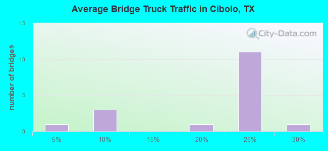
- 86,339Total average daily truck traffic
- National Bridge Inventory (NBI) Registered Bridges for Cibolo
- No street view available for this location
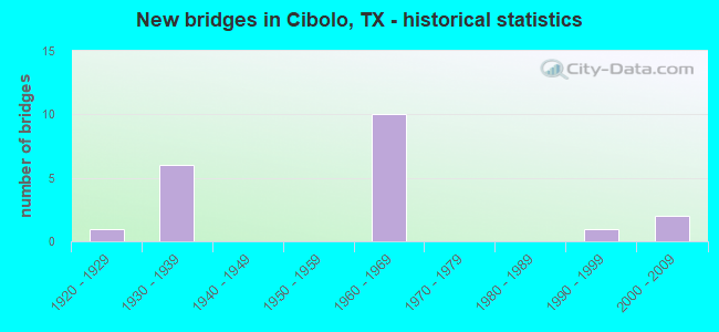
- New bridges - historical statistics
- 11920-1929
- 61930-1939
- 101960-1969
- 11990-1999
- 22000-2009
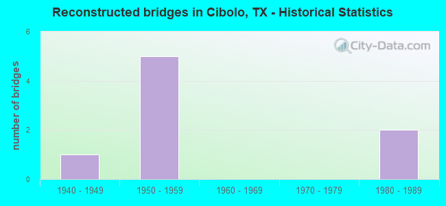
- Reconstructed bridges - Historical Statistics
- 11940-1949
- 51950-1959
- 01960-1969
- 01970-1979
- 21980-1989

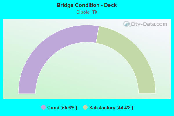
- Bridge Condition - Deck
- 55.6%Good
- 44.4%Satisfactory
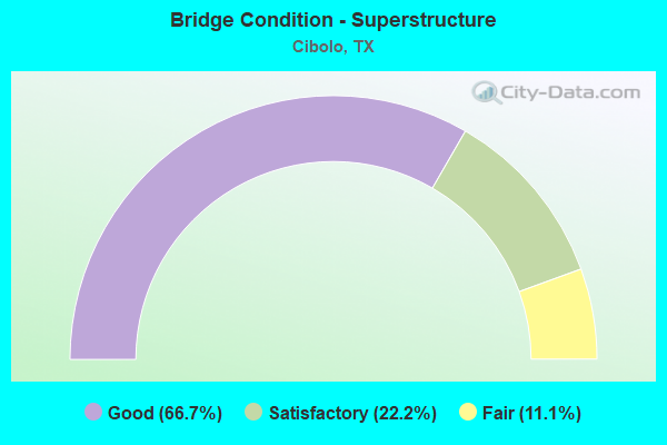
- Bridge Condition - Superstructure
- 66.7%Good
- 22.2%Satisfactory
- 11.1%Fair
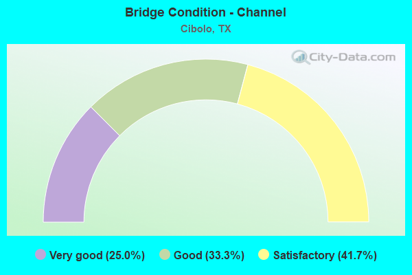
- Bridge Condition - Channel
- 25.0%Very good
- 33.3%Good
- 41.7%Satisfactory
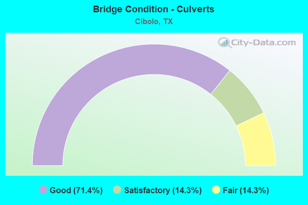
- Bridge Condition - Culverts
- 71.4%Good
- 14.3%Satisfactory
- 14.3%Fair
Find on map >> Show street view
Structure Number: 150950002503012, Location: 0.50 MI E OF BEXAR C/L (Lat: 29.504097, Lng: -98.178303), Route carried "on" structure: Interstate 10, Year Built: 1932, Year Reconstructed: 1961, Status: Open, Structure Length: 1.16m (3.81ft), Average Daily Traffic: 36,756 (year 2020), Truck Traffic: 22%, Average Future Daily Traffic: 47,920 (year 2033), Design Load: H 15, Features Intersected: DRAW
Minimum Vertical Clearance: 30+ m (98+ ft), Kilometerpoint: 0.845, Lanes on structure: 8, Owner: State Highway Agency, Approaching Roadway Width: 36.6m (120.1ft), Skew: 29 degrees, Material/Design: Concrete, Design/Construction: Culvert, Number Of Spans In Main Unit: 4, Length of Maximum Span: 1.8m (5.9ft), Curb-To-Curb Width: 36.6m (120.1ft), Out-to-Out Width: 76.2m (250.0ft)
Condition: Channel: Satisfactory, Culverts: Good, Operating Rating: 39.9 metric tons, Method Used To Determine Operating Rating: Load Factor (LF), Inventory Rating: 23.6 metric tons, Method Used To Determine Inventory Rating: Load Factor (LF), Structural Evaluation: Somewhat better than minimum adequacy, Deck Geometry: Better than present minimum criteria, Waterway Adequacy: Equal to present minimum criteria, Approach Roadway Alignment: Equal to present desirable criteria, Designated Inspection Frequency: Every 24 months, Inspection Date: August 2020, Deck Structure Type: Concrete Cast-file-Place, Wearing Surface/Protective System: Wearing Surface: Bituminous
Find on map >> Show street view
Structure Number: 150950002503013, Location: 1.00 MI E OF BEXAR C/L (Lat: 29.507397, Lng: -98.169594), Route carried "on" structure: Interstate 10, Year Built: 1932, Year Reconstructed: 1961, Status: Open, Structure Length: 1.19m (3.90ft), Average Daily Traffic: 36,756 (year 2020), Truck Traffic: 22%, Average Future Daily Traffic: 47,920 (year 2033), Design Load: H 15, Features Intersected: DRAW
Minimum Vertical Clearance: 30+ m (98+ ft), Kilometerpoint: 1.616, Lanes on structure: 8, Owner: State Highway Agency, Approaching Roadway Width: 36.6m (120.1ft), Skew: 29 degrees, Material/Design: Concrete, Design/Construction: Culvert, Number Of Spans In Main Unit: 6, Length of Maximum Span: 1.8m (5.9ft)
Condition: Channel: Good, Culverts: Good, Operating Rating: 39.9 metric tons, Method Used To Determine Operating Rating: Load Factor (LF), Inventory Rating: 23.6 metric tons, Method Used To Determine Inventory Rating: Load Factor (LF), Structural Evaluation: Somewhat better than minimum adequacy, Waterway Adequacy: Equal to present minimum criteria, Approach Roadway Alignment: Equal to present desirable criteria, Designated Inspection Frequency: Every 24 months, Inspection Date: August 2020
Find on map >> Show street view
Structure Number: 150950002503014, Location: 2.40 MI E OF BEXAR C/L (Lat: 29.515108, Lng: -98.149111), Route carried "on" structure: Interstate 10, Year Built: 1932, Year Reconstructed: 1961, Status: Open, Structure Length: 1.22m (4.00ft), Average Daily Traffic: 36,756 (year 2020), Truck Traffic: 22%, Average Future Daily Traffic: 47,920 (year 2033), Design Load: H 15, Features Intersected: DRAW
Minimum Vertical Clearance: 30+ m (98+ ft), Kilometerpoint: 3.901, Lanes on structure: 8, Owner: State Highway Agency, Approaching Roadway Width: 36.6m (120.1ft), Skew: 20 degrees, Material/Design: Concrete, Design/Construction: Culvert, Number Of Spans In Main Unit: 6, Length of Maximum Span: 1.8m (5.9ft), Curb-To-Curb Width: 36.6m (120.1ft), Out-to-Out Width: 76.6m (251.3ft)
Condition: Channel: Very good, Culverts: Good, Operating Rating: 39.9 metric tons, Method Used To Determine Operating Rating: Load Factor (LF), Inventory Rating: 23.6 metric tons, Method Used To Determine Inventory Rating: Load Factor (LF), Structural Evaluation: Somewhat better than minimum adequacy, Deck Geometry: Better than present minimum criteria, Waterway Adequacy: Equal to present minimum criteria, Approach Roadway Alignment: Equal to present desirable criteria, Designated Inspection Frequency: Every 24 months, Inspection Date: August 2020, Deck Structure Type: Concrete Cast-file-Place, Wearing Surface/Protective System: Wearing Surface: Bituminous
Find on map >> Show street view
Structure Number: 150950002503015, Location: 2.75 MI E OF BEXAR C/L (Lat: 29.517178, Lng: -98.143683), Route carried "on" structure: Interstate 10, Year Built: 1932, Year Reconstructed: 1961, Status: Open, Structure Length: 0.82m (2.69ft), Average Daily Traffic: 36,756 (year 2020), Truck Traffic: 22%, Average Future Daily Traffic: 47,920 (year 2033), Design Load: H 15, Features Intersected: DRAW
Minimum Vertical Clearance: 30+ m (98+ ft), Kilometerpoint: 4.469, Lanes on structure: 8, Owner: State Highway Agency, Approaching Roadway Width: 36.6m (120.1ft), Skew: 20 degrees, Material/Design: Concrete, Design/Construction: Culvert, Number Of Spans In Main Unit: 4, Length of Maximum Span: 1.8m (5.9ft), Curb-To-Curb Width: 36.6m (120.1ft), Out-to-Out Width: 78.1m (256.2ft)
Condition: Channel: Satisfactory, Culverts: Satisfactory, Operating Rating: 39.9 metric tons, Method Used To Determine Operating Rating: Load Factor (LF), Inventory Rating: 23.6 metric tons, Method Used To Determine Inventory Rating: Load Factor (LF), Structural Evaluation: Somewhat better than minimum adequacy, Deck Geometry: Better than present minimum criteria, Waterway Adequacy: Equal to present minimum criteria, Approach Roadway Alignment: Equal to present desirable criteria, Designated Inspection Frequency: Every 24 months, Inspection Date: August 2020, Deck Structure Type: Concrete Cast-file-Place, Wearing Surface/Protective System: Wearing Surface: Bituminous
Find on map >> Show street view
Structure Number: 150950002503016, Location: 0.35 MI W OF JCT FM 465 (Lat: 29.527417, Lng: -98.117578), Route carried "on" structure: ServiceInterstate 10, Year Built: 1932, Status: Open, Structure Length: 10.42m (34.19ft), Average Daily Traffic: 160 (year 2010), Truck Traffic: 3%, Average Future Daily Traffic: 180 (year 2030), Features Intersected: SANTA CLARA CREEK
Minimum Vertical Clearance: 30+ m (98+ ft), Kilometerpoint: 7.202, Lanes on structure: 2, Owner: State Highway Agency, Approaching Roadway Width: 7.3m (24.0ft), Material/Design: Concrete, Design/Construction: Tee Beam, Number Of Spans In Main Unit: 12, Length of Maximum Span: 8.8m (28.9ft), Curb-To-Curb Width: 6.9m (22.6ft), Out-to-Out Width: 8.2m (26.9ft)
Condition: Deck: Good, Superstructure: Satisfactory, Substructure: Satisfactory, Channel: Very good, Operating Rating: 54.4 metric tons, Method Used To Determine Operating Rating: Load Factor (LF), Inventory Rating: 32.7 metric tons, Method Used To Determine Inventory Rating: Load Factor (LF), Structural Evaluation: Equal to present minimum criteria, Deck Geometry: Meets minimum limits, Waterway Adequacy: Better than present minimum criteria, Approach Roadway Alignment: Equal to present desirable criteria, Length Of Structure Improvement: 10.42m (34.19ft), Designated Inspection Frequency: Every 24 months, Inspection Date: August 2020, Bridge Improvement Cost: $16,000, Roadway Improvement Cost: $4,000, Total Project Cost: $20,000, Deck Structure Type: Concrete Cast-file-Place, Wearing Surface/Protective System: Wearing Surface: Bituminous
Find on map >> Show street view
Structure Number: 150950002503017, Location: 0.1 MI E OF JCT FM 465 (Lat: 29.529317, Lng: -98.111203), Route carried "on" structure: Interstate 10, Year Built: 1932, Year Reconstructed: 1961, Status: Open, Structure Length: 2.07m (6.79ft), Average Daily Traffic: 39,260 (year 2020), Truck Traffic: 24%, Average Future Daily Traffic: 55,080 (year 2033), Design Load: H 15, Features Intersected: BUZZARD CREEK
Minimum Vertical Clearance: 30+ m (98+ ft), Kilometerpoint: 7.875, Lanes on structure: 8, Owner: State Highway Agency, Approaching Roadway Width: 36.6m (120.1ft), Skew: 20 degrees, Material/Design: Concrete, Design/Construction: Culvert, Number Of Spans In Main Unit: 12, Length of Maximum Span: 1.5m (4.9ft), Curb-To-Curb Width: 36.6m (120.1ft), Out-to-Out Width: 79.2m (259.8ft)
Condition: Channel: Good, Culverts: Fair, Operating Rating: 39.9 metric tons, Method Used To Determine Operating Rating: Load Factor (LF), Inventory Rating: 23.6 metric tons, Method Used To Determine Inventory Rating: Load Factor (LF), Structural Evaluation: Somewhat better than minimum adequacy, Deck Geometry: Better than present minimum criteria, Waterway Adequacy: Equal to present minimum criteria, Approach Roadway Alignment: Equal to present desirable criteria, Designated Inspection Frequency: Every 24 months, Inspection Date: August 2020, Deck Structure Type: Concrete Cast-file-Place, Wearing Surface/Protective System: Wearing Surface: Bituminous
Find on map >> Show street view
Structure Number: 150950002503117, Location: 1.15 MI E OF BEXAR C/L (Lat: 29.507967, Lng: -98.168086), Route carried "on" structure: County highway , Year Built: 1961, Status: Open, Structure Length: 7.92m (25.98ft), Average Daily Traffic: 390 (year 2010), Average Future Daily Traffic: 200 (year 2030), Design Load: H 15, Features Intersected: IH 10, Facility Carried by Structure: ZUEHL RD
Minimum Vertical Clearance: 30+ m (98+ ft), Kilometerpoint: 0.354, Lanes on structure: 2, Lanes under structure: 8, Owner: State Highway Agency, Approaching Roadway Width: 7.3m (24.0ft), Material/Design: Prestressed concrete, Design/Construction: Stringer/Multi-beam, Number Of Spans In Main Unit: 4, Length of Maximum Span: 19.8m (65.0ft), Curb-To-Curb Width: 7.3m (24.0ft), Out-to-Out Width: 7.8m (25.6ft)
Condition: Deck: Satisfactory, Superstructure: Good, Substructure: Satisfactory, Operating Rating: 67.1 metric tons, Method Used To Determine Operating Rating: Load Factor (LF), Inventory Rating: 29.0 metric tons, Method Used To Determine Inventory Rating: Load Factor (LF), Structural Evaluation: Equal to present minimum criteria, Deck Geometry: Somewhat better than minimum adequacy, Underclear: Equal to present minimum criteria, Approach Roadway Alignment: Equal to present minimum criteria, Length Of Structure Improvement: 7.92m (25.98ft), Designated Inspection Frequency: Every 24 months, Inspection Date: August 2020, Bridge Improvement Cost: $398,000, Roadway Improvement Cost: $40,000, Total Project Cost: $597,000, Deck Structure Type: Concrete Cast-file-Place
Find on map >> Show street view
Structure Number: 150950002503118, Location: 3.10 MI E OF BEXAR C/L (Lat: 29.518961, Lng: -98.138942), Route carried "on" structure: County highway , Year Built: 1961, Status: Open, Structure Length: 7.92m (25.98ft), Average Daily Traffic: 350 (year 2010), Average Future Daily Traffic: 250 (year 2030), Design Load: H 15, Features Intersected: IH 10, Facility Carried by Structure: SANTA CLARA RD
Minimum Vertical Clearance: 30+ m (98+ ft), Kilometerpoint: 5.713, Lanes on structure: 2, Lanes under structure: 8, Owner: State Highway Agency, Approaching Roadway Width: 7.3m (24.0ft), Material/Design: Prestressed concrete, Design/Construction: Stringer/Multi-beam, Number Of Spans In Main Unit: 4, Length of Maximum Span: 19.8m (65.0ft), Curb-To-Curb Width: 7.3m (24.0ft), Out-to-Out Width: 7.8m (25.6ft)
Condition: Deck: Satisfactory, Superstructure: Good, Substructure: Satisfactory, Operating Rating: 67.1 metric tons, Method Used To Determine Operating Rating: Load Factor (LF), Inventory Rating: 29.0 metric tons, Method Used To Determine Inventory Rating: Load Factor (LF), Structural Evaluation: Equal to present minimum criteria, Deck Geometry: Somewhat better than minimum adequacy, Underclear: Somewhat better than minimum adequacy, Approach Roadway Alignment: Somewhat better than minimum adequacy, Length Of Structure Improvement: 7.92m (25.98ft), Designated Inspection Frequency: Every 24 months, Inspection Date: August 2020, Bridge Improvement Cost: $398,000, Roadway Improvement Cost: $40,000, Total Project Cost: $597,000, Deck Structure Type: Concrete Cast-file-Place
Find on map >> Show street view
Structure Number: 150950002503119, Location: 0.35 MI W OF JCT FM 465 (Lat: 29.527108, Lng: -98.117492), Route carried "on" structure: Interstate 10, Year Built: 1961, Year Reconstructed: 1988, Status: Open, Structure Length: 12.19m (39.99ft), Average Daily Traffic: 20,204 (year 2018), Truck Traffic: 22%, Average Future Daily Traffic: 23,960 (year 2033), Design Load: HS 20, Features Intersected: SANTA CLARA CREEK
Minimum Vertical Clearance: 30+ m (98+ ft), Kilometerpoint: 7.191, Lanes on structure: 2, Owner: State Highway Agency, Approaching Roadway Width: 11.6m (38.1ft), Material/Design: Concrete, Design/Construction: Stringer/Multi-beam, Number Of Spans In Main Unit: 10, Length of Maximum Span: 12.2m (40.0ft), Curb-To-Curb Width: 11.6m (38.1ft), Out-to-Out Width: 12.3m (40.4ft)
Condition: Deck: Good, Superstructure: Good, Substructure: Satisfactory, Channel: Satisfactory, Operating Rating: 56.2 metric tons, Method Used To Determine Operating Rating: Load Factor (LF), Inventory Rating: 33.6 metric tons, Method Used To Determine Inventory Rating: Load Factor (LF), Structural Evaluation: Equal to present minimum criteria, Deck Geometry: Equal to present minimum criteria, Waterway Adequacy: Equal to present desirable criteria, Approach Roadway Alignment: Equal to present desirable criteria, Designated Inspection Frequency: Every 24 months, Inspection Date: August 2020, Deck Structure Type: Concrete Cast-file-Place, Wearing Surface/Protective System: Wearing Surface: Bituminous
Find on map >> Show street view
Structure Number: 15095000250312, Location: 0.35 MI W OF JCT FM 465 (Lat: 29.527025, Lng: -98.117444), Route carried "on" structure: Interstate 10, Year Built: 1961, Year Reconstructed: 1988, Status: Open, Structure Length: 12.19m (39.99ft), Average Daily Traffic: 22,551 (year 2019), Truck Traffic: 22%, Average Future Daily Traffic: 23,960 (year 2033), Design Load: HS 20, Features Intersected: SANTA CLARA CREEK
Minimum Vertical Clearance: 30+ m (98+ ft), Kilometerpoint: 7.191, Lanes on structure: 2, Owner: State Highway Agency, Approaching Roadway Width: 11.6m (38.1ft), Material/Design: Concrete, Design/Construction: Stringer/Multi-beam, Number Of Spans In Main Unit: 10, Length of Maximum Span: 12.2m (40.0ft), Curb-To-Curb Width: 11.6m (38.1ft), Out-to-Out Width: 12.3m (40.4ft)
Condition: Deck: Good, Superstructure: Good, Substructure: Satisfactory, Channel: Satisfactory, Operating Rating: 60.8 metric tons, Method Used To Determine Operating Rating: Load Factor (LF), Inventory Rating: 36.3 metric tons, Method Used To Determine Inventory Rating: Load Factor (LF), Structural Evaluation: Equal to present minimum criteria, Deck Geometry: Equal to present minimum criteria, Waterway Adequacy: Superior to present desirable criteria, Approach Roadway Alignment: Equal to present desirable criteria, Length Of Structure Improvement: 12.19m (39.99ft), Designated Inspection Frequency: Every 24 months, Inspection Date: August 2020, Bridge Improvement Cost: $970,000, Roadway Improvement Cost: $97,000, Total Project Cost: $1,454,000, Deck Structure Type: Concrete Cast-file-Place, Wearing Surface/Protective System: Wearing Surface: Bituminous
Find on map >> Show street view
Structure Number: 150950002503121, Location: FM 465 @ IH 10 (Lat: 29.528733, Lng: -98.112125), Route carried "on" structure: State highway 465, Year Built: 1961, Status: Open, Structure Length: 7.92m (25.98ft), Average Daily Traffic: 1,910 (year 2013), Truck Traffic: 25%, Average Future Daily Traffic: 2,670 (year 2033), Design Load: H 15, Features Intersected: IH 10
Minimum Vertical Clearance: 30+ m (98+ ft), Kilometerpoint: 7.417, Lanes on structure: 2, Lanes under structure: 8, Owner: State Highway Agency, Approaching Roadway Width: 6.4m (21.0ft), Material/Design: Prestressed concrete, Design/Construction: Stringer/Multi-beam, Number Of Spans In Main Unit: 4, Length of Maximum Span: 19.8m (65.0ft), Curb-To-Curb Width: 7.3m (24.0ft), Out-to-Out Width: 7.8m (25.6ft)
Condition: Deck: Satisfactory, Superstructure: Fair, Substructure: Satisfactory, Operating Rating: 67.1 metric tons, Method Used To Determine Operating Rating: Load Factor (LF), Inventory Rating: 29.0 metric tons, Method Used To Determine Inventory Rating: Load Factor (LF), Structural Evaluation: Somewhat better than minimum adequacy, Deck Geometry: Meets minimum limits, Underclear: Somewhat better than minimum adequacy, Approach Roadway Alignment: Equal to present minimum criteria, Length Of Structure Improvement: 7.92m (25.98ft), Designated Inspection Frequency: Every 24 months, Inspection Date: August 2020, Bridge Improvement Cost: $398,000, Roadway Improvement Cost: $40,000, Total Project Cost: $597,000, Deck Structure Type: Concrete Cast-file-Place
Find on map >> Show street view
Structure Number: 150950002503122, Location: 1.7 MI E OF JCT FM 465 (Lat: 29.536133, Lng: -98.085531), Route carried "on" structure: County highway , Year Built: 1961, Status: Open, Structure Length: 7.92m (25.98ft), Average Daily Traffic: 300 (year 2010), Average Future Daily Traffic: 200 (year 2030), Design Load: H 15, Features Intersected: IH 10, Facility Carried by Structure: SCHWAB RD
Minimum Vertical Clearance: 30+ m (98+ ft), Kilometerpoint: 0.499, Lanes on structure: 2, Lanes under structure: 8, Owner: State Highway Agency, Approaching Roadway Width: 7.3m (24.0ft), Material/Design: Prestressed concrete, Design/Construction: Stringer/Multi-beam, Number Of Spans In Main Unit: 4, Length of Maximum Span: 19.8m (65.0ft), Curb-To-Curb Width: 7.3m (24.0ft), Out-to-Out Width: 7.8m (25.6ft)
Condition: Deck: Satisfactory, Superstructure: Satisfactory, Substructure: Satisfactory, Operating Rating: 68.0 metric tons, Method Used To Determine Operating Rating: Load Factor (LF), Inventory Rating: 40.8 metric tons, Method Used To Determine Inventory Rating: Load Factor (LF), Structural Evaluation: Equal to present minimum criteria, Deck Geometry: Somewhat better than minimum adequacy, Underclear: Somewhat better than minimum adequacy, Approach Roadway Alignment: Equal to present minimum criteria, Length Of Structure Improvement: 7.92m (25.98ft), Designated Inspection Frequency: Every 24 months, Inspection Date: August 2020, Bridge Improvement Cost: $398,000, Roadway Improvement Cost: $40,000, Total Project Cost: $597,000, Deck Structure Type: Concrete Cast-file-Place
Find on map >> Show street view
Structure Number: 150950002510057, Location: 0.30 MI W OF FM 78 (Lat: 29.561831, Lng: -98.222633), Route carried "on" structure: State highway 539, Year Built: 1922, Year Reconstructed: 1953, Status: Open, Structure Length: 3.35m (10.99ft), Average Daily Traffic: 780 (year 2011), Truck Traffic: 7%, Average Future Daily Traffic: 1,450 (year 2031), Features Intersected: TOWN CREEK
Minimum Vertical Clearance: 30+ m (98+ ft), Kilometerpoint: 33.099, Lanes on structure: 2, Owner: State Highway Agency, Approaching Roadway Width: 7.3m (24.0ft), Material/Design: Concrete, Design/Construction: Slab, Number Of Spans In Main Unit: 5, Length of Maximum Span: 6.7m (22.0ft), Curb-To-Curb Width: 8.5m (27.9ft), Out-to-Out Width: 9.4m (30.8ft)
Condition: Deck: Good, Superstructure: Good, Substructure: Satisfactory, Channel: Very good, Operating Rating: 52.6 metric tons, Method Used To Determine Operating Rating: Load Factor (LF), Inventory Rating: 29.0 metric tons, Method Used To Determine Inventory Rating: Load Factor (LF), Structural Evaluation: Equal to present minimum criteria, Deck Geometry: Somewhat better than minimum adequacy, Waterway Adequacy: Better than present minimum criteria, Approach Roadway Alignment: Equal to present desirable criteria, Length Of Structure Improvement: 3.35m (10.99ft), Designated Inspection Frequency: Every 24 months, Inspection Date: August 2020, Bridge Improvement Cost: $203,000, Roadway Improvement Cost: $20,000, Total Project Cost: $304,000, Deck Structure Type: Concrete Cast-file-Place, Wearing Surface/Protective System: Wearing Surface: Bituminous
Find on map >> Show street view
Structure Number: 150950002511224, Location: 1.15 MI E OF FM 1103 (Lat: 29.560267, Lng: -98.221483), Route carried "on" structure: State highway 78, Year Built: 1995, Status: Open, Structure Length: 15.09m (49.51ft), Average Daily Traffic: 9,990 (year 2020), Truck Traffic: 15%, Average Future Daily Traffic: 11,480 (year 2035), Design Load: HS 20, Features Intersected: TOWN CREEK
Minimum Vertical Clearance: 30+ m (98+ ft), Kilometerpoint: 33.099, Lanes on structure: 4, Owner: State Highway Agency, Approaching Roadway Width: 21.3m (69.9ft), Skew: 1 degrees, Material/Design: Concrete, Design/Construction: Slab, Number Of Spans In Main Unit: 20, Length of Maximum Span: 7.6m (24.9ft), Curb-To-Curb Width: 20.7m (67.9ft), Out-to-Out Width: 21.3m (69.9ft)
Condition: Deck: Good, Superstructure: Good, Substructure: Satisfactory, Channel: Satisfactory, Operating Rating: 54.4 metric tons, Method Used To Determine Operating Rating: Assigned rating based on Load Factor Design (LFD) reported in metric tons, Inventory Rating: 32.7 metric tons, Method Used To Determine Inventory Rating: Assigned rating based on Load Factor Design (LFD) reported in metric tons, Structural Evaluation: Equal to present minimum criteria, Deck Geometry: Superior to present desirable criteria, Waterway Adequacy: Equal to present minimum criteria, Approach Roadway Alignment: Equal to present desirable criteria, Length Of Structure Improvement: 3.35m (10.99ft), Designated Inspection Frequency: Every 24 months, Inspection Date: August 2020, Bridge Improvement Cost: $2,079,000, Roadway Improvement Cost: $208,000, Total Project Cost: $3,118,000, Deck Structure Type: Concrete Cast-file-Place, Wearing Surface/Protective System: Wearing Surface: Bituminous
Find on map >> Show street view
Structure Number: 150950126802002, Location: 1.4 MI NE OF FM 78 (Lat: 29.575217, Lng: -98.224603), Route carried "on" structure: State highway 1103, Year Built: 2008, Status: Open, Structure Length: 2.38m (7.81ft), Average Daily Traffic: 11,045 (year 2020), Truck Traffic: 5%, Average Future Daily Traffic: 13,160 (year 2033), Design Load: HS 20, Features Intersected: TOWN CREEK
Minimum Vertical Clearance: 30+ m (98+ ft), Kilometerpoint: 8.219, Lanes on structure: 2, Owner: State Highway Agency, Approaching Roadway Width: 12.2m (40.0ft), Material/Design: Concrete, Design/Construction: Culvert, Number Of Spans In Main Unit: 8, Length of Maximum Span: 2.4m (7.9ft), Curb-To-Curb Width: 12.8m (42.0ft), Out-to-Out Width: 13.7m (44.9ft)
Condition: Channel: Good, Culverts: Good, Operating Rating: 54.4 metric tons, Method Used To Determine Operating Rating: Assigned rating based on Load Factor Design (LFD) reported in metric tons, Inventory Rating: 32.7 metric tons, Method Used To Determine Inventory Rating: Assigned rating based on Load Factor Design (LFD) reported in metric tons, Structural Evaluation: Better than present minimum criteria, Deck Geometry: Somewhat better than minimum adequacy, Waterway Adequacy: Equal to present minimum criteria, Approach Roadway Alignment: Equal to present desirable criteria, Designated Inspection Frequency: Every 48 months, Inspection Date: August 2020, Deck Structure Type: Concrete Cast-file-Place, Wearing Surface/Protective System: Wearing Surface: Bituminous
Find on map >> Show street view
Structure Number: 150950126802003, Location: 1.0 MI NE OF FM 78 (Lat: 29.572144, Lng: -98.230481), Route carried "on" structure: State highway 1103, Year Built: 2008, Status: Open, Structure Length: 2.38m (7.81ft), Average Daily Traffic: 11,045 (year 2020), Truck Traffic: 5%, Average Future Daily Traffic: 13,160 (year 2033), Design Load: HS 20, Features Intersected: TOWN CREEK
Minimum Vertical Clearance: 30+ m (98+ ft), Kilometerpoint: 8.884, Lanes on structure: 2, Owner: State Highway Agency, Approaching Roadway Width: 12.2m (40.0ft), Material/Design: Concrete, Design/Construction: Culvert, Number Of Spans In Main Unit: 8, Length of Maximum Span: 2.4m (7.9ft), Curb-To-Curb Width: 12.9m (42.3ft), Out-to-Out Width: 13.7m (44.9ft)
Condition: Channel: Good, Culverts: Good, Operating Rating: 54.4 metric tons, Method Used To Determine Operating Rating: Assigned rating based on Load Factor Design (LFD) reported in metric tons, Inventory Rating: 32.7 metric tons, Method Used To Determine Inventory Rating: Assigned rating based on Load Factor Design (LFD) reported in metric tons, Structural Evaluation: Better than present minimum criteria, Deck Geometry: Somewhat better than minimum adequacy, Waterway Adequacy: High priority of corrective action, Approach Roadway Alignment: Equal to present desirable criteria, Designated Inspection Frequency: Every 48 months, Inspection Date: August 2020, Deck Structure Type: Concrete Precast Panels, Wearing Surface/Protective System: Wearing Surface: Bituminous
Find on map >> Show street view
Structure Number: 150950002503117, Location: 1.15 MI E OF BEXAR C/L (Lat: 29.507967, Lng: -98.168086), Route carried "under" structure: Interstate 10, Year Built: 1961, Structure Length: 0. m, Average Daily Traffic: 34,230 (year 2013), Truck Traffic: 22%, Features Intersected: IH 10, Facility Carried by Structure: ZUEHL RD
Minimum Vertical Clearance: 5.08m (16.67ft), Kilometerpoint: 1.910, Material/Design: Prestressed concrete, Design/Construction: Stringer/Multi-beam, Length of Maximum Span: 19.8m (65.0ft)
Find on map >> Show street view
Structure Number: 150950002503118, Location: 3.10 MI E OF BEXAR C/L (Lat: 29.518961, Lng: -98.138942), Route carried "under" structure: Interstate 10, Year Built: 1961, Structure Length: 0. m, Average Daily Traffic: 34,230 (year 2013), Truck Traffic: 22%, Features Intersected: IH 10, Facility Carried by Structure: SANTA CLARA RD
Minimum Vertical Clearance: 4.95m (16.24ft), Kilometerpoint: 4.989, Material/Design: Prestressed concrete, Design/Construction: Stringer/Multi-beam, Length of Maximum Span: 19.8m (65.0ft)
Find on map >> Show street view
Structure Number: 150950002503121, Location: FM 465 @ IH 10 (Lat: 29.528733, Lng: -98.112125), Route carried "under" structure: Interstate 10, Year Built: 1961, Structure Length: 0. m, Average Daily Traffic: 34,230 (year 2013), Truck Traffic: 22%, Features Intersected: IH 10, Facility Carried by Structure: FM 465
Minimum Vertical Clearance: 4.88m (16.01ft), Kilometerpoint: 7.794, Material/Design: Prestressed concrete, Design/Construction: Stringer/Multi-beam, Length of Maximum Span: 19.8m (65.0ft)
Find on map >> Show street view
Structure Number: 150950002503122, Location: 1.7 MI E OF JCT FM 465 (Lat: 29.536133, Lng: -98.085531), Route carried "under" structure: Interstate 10, Year Built: 1961, Structure Length: 0. m, Average Daily Traffic: 39,340 (year 2013), Truck Traffic: 24%, Features Intersected: IH 10, Facility Carried by Structure: SCHWAB RD
Minimum Vertical Clearance: 4.93m (16.17ft), Kilometerpoint: 10.522, Material/Design: Prestressed concrete, Design/Construction: Stringer/Multi-beam, Length of Maximum Span: 19.8m (65.0ft)