Bridge Statistics for Claysville, Pennsylvania (PA)
Condition, Traffic, Stress, Structural Evaluation, Project Costs
- National Bridge Inventory (NBI) Statistics
- 19Number of bridges
- 138ft / 42.3mTotal length
- $3,133,000Total costs
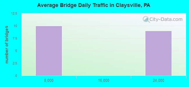
- 172,540Total average daily traffic
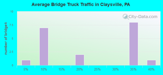
- 55,003Total average daily truck traffic
- National Bridge Inventory (NBI) Registered Bridges for Claysville
- No street view available for this location
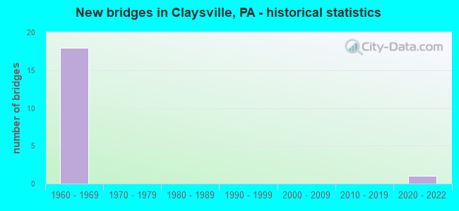
- New bridges - historical statistics
- 181960-1969
- 12020-2022
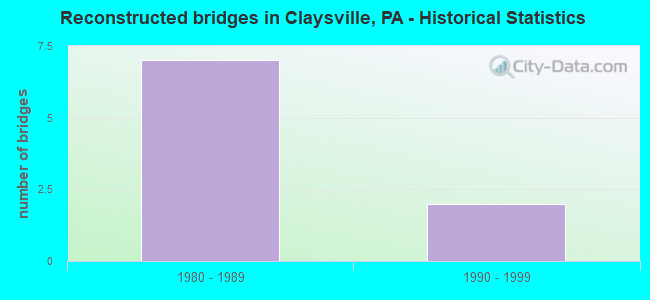
- Reconstructed bridges - Historical Statistics
- 71980-1989
- 21990-1999
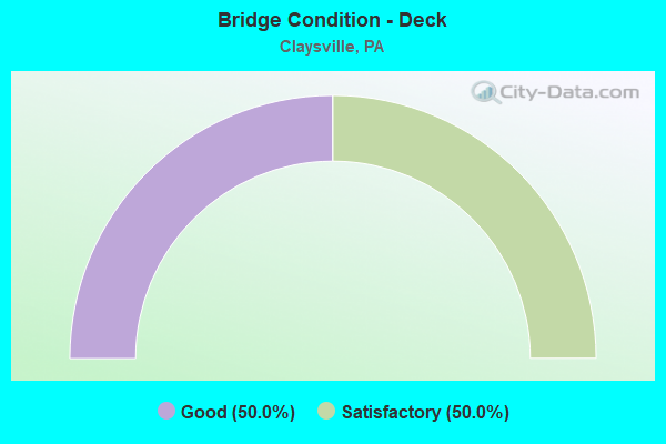
- Bridge Condition - Deck
- 50.0%Good
- 50.0%Satisfactory
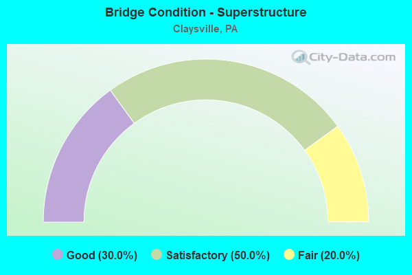
- Bridge Condition - Superstructure
- 30.0%Good
- 50.0%Satisfactory
- 20.0%Fair
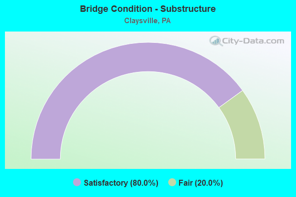
- Bridge Condition - Substructure
- 80.0%Satisfactory
- 20.0%Fair
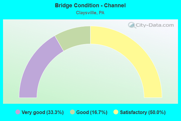
- Bridge Condition - Channel
- 33.3%Very good
- 16.7%Good
- 50.0%Satisfactory
Find on map >> Show street view
Structure Number: 34435, Location: DONEGAL TOWNSHIP (Lat: 40.116181, Lng: -80.445278), Route carried "on" structure: Interstate 70, Year Built: 1961, Year Reconstructed: 1995, Status: Open, Structure Length: 1.07m (3.51ft), Average Daily Traffic: 16,306 (year 2022), Truck Traffic: 34%, Average Future Daily Traffic: 18,372 (year 2032), Design Load: HS 25 or greater, Features Intersected: DUTCH FORK BUFFALO CREEK
Minimum Vertical Clearance: 30+ m (98+ ft), Kilometerpoint: 7.245, Lanes on structure: 3, Base Highway Network: Yes, Owner: State Highway Agency, Approaching Roadway Width: 11.6m (38.1ft), Skew: 13 degrees, Material/Design: Prestressed concrete, Design/Construction: Box Beam or Girders - Multiple, Number Of Spans In Main Unit: 1, Length of Maximum Span: 10.4m (34.1ft), Curb or Sidewalk Widths: Left: 0.2m (0.7ft), Right: 0.2m (0.7ft), Curb-To-Curb Width: 12.5m (41.0ft), Out-to-Out Width: 20.4m (66.9ft)
Condition: Deck: Satisfactory, Superstructure: Good, Substructure: Satisfactory, Channel: Satisfactory, Inventory Rating: 76.2 metric tons, Method Used To Determine Inventory Rating: Load Factor (LF), Structural Evaluation: Equal to present minimum criteria, Deck Geometry: High priority of replacement, Waterway Adequacy: Superior to present desirable criteria, Approach Roadway Alignment: Equal to present desirable criteria, Length Of Structure Improvement: 1.80m (5.91ft), Designated Inspection Frequency: Every 24 months, Inspection Date: August 2021, Deck Structure Type: Concrete Cast-file-Place, Wearing Surface/Protective System: Wearing Surface: Bituminous, Deck Protection: Epoxy Coated Reinforcing
Find on map >> Show street view
Structure Number: 34437, Location: DONEGAL TOWNSHIP (Lat: 40.116494, Lng: -80.445661), Route carried "on" structure: Interstate 70, Year Built: 1961, Year Reconstructed: 1990, Status: Open, Structure Length: 1.04m (3.41ft), Average Daily Traffic: 16,634 (year 2022), Truck Traffic: 35%, Average Future Daily Traffic: 18,158 (year 2032), Design Load: HS 25 or greater, Features Intersected: DUTCH FORK BUFFALO CREEK
Minimum Vertical Clearance: 30+ m (98+ ft), Kilometerpoint: 7.245, Lanes on structure: 2, Base Highway Network: Yes, Owner: State Highway Agency, Approaching Roadway Width: 12.5m (41.0ft), Skew: 13 degrees, Material/Design: Prestressed concrete, Design/Construction: Box Beam or Girders - Multiple, Number Of Spans In Main Unit: 1, Length of Maximum Span: 9.8m (32.2ft), Curb or Sidewalk Widths: Left: 0.2m (0.7ft), Right: 0.2m (0.7ft), Curb-To-Curb Width: 12.5m (41.0ft), Out-to-Out Width: 13.6m (44.6ft)
Condition: Deck: Good, Superstructure: Good, Substructure: Satisfactory, Channel: Satisfactory, Operating Rating: 72.6 metric tons, Method Used To Determine Operating Rating: Load Factor (LF), Inventory Rating: 39.9 metric tons, Method Used To Determine Inventory Rating: Load Factor (LF), Structural Evaluation: Equal to present minimum criteria, Deck Geometry: Better than present minimum criteria, Waterway Adequacy: Superior to present desirable criteria, Approach Roadway Alignment: Equal to present desirable criteria, Length Of Structure Improvement: 1.80m (5.91ft), Designated Inspection Frequency: Every 24 months, Inspection Date: August 2021, Deck Structure Type: Concrete Cast-file-Place, Wearing Surface/Protective System: Wearing Surface: Bituminous, Deck Protection: Epoxy Coated Reinforcing
Find on map >> Show street view
Structure Number: 34439, Location: DONEGAL TOWNSHIP (Lat: 40.114947, Lng: -80.428708), Route carried "on" structure: Interstate 70, Year Built: 1960, Year Reconstructed: 1988, Status: Open, Structure Length: 4.02m (13.19ft), Average Daily Traffic: 17,901 (year 2022), Truck Traffic: 34%, Average Future Daily Traffic: 18,372 (year 2032), Design Load: HS 20+Mod, Features Intersected: SR 3024
Minimum Vertical Clearance: 30+ m (98+ ft), Kilometerpoint: 8.848, Lanes on structure: 2, Lanes under structure: 2, Base Highway Network: Yes, Owner: State Highway Agency, Approaching Roadway Width: 12.8m (42.0ft), Skew: 13 degrees, Material/Design: Prestressed concrete, Design/Construction: Box Beam or Girders - Single/Spread, Number Of Spans In Main Unit: 3, Length of Maximum Span: 15.2m (49.9ft), Curb or Sidewalk Widths: Left: 0.3m (1.0ft), Right: 0.3m (1.0ft), Curb-To-Curb Width: 12.2m (40.0ft), Out-to-Out Width: 13.9m (45.6ft)
Condition: Deck: Satisfactory, Superstructure: Satisfactory, Substructure: Satisfactory, Operating Rating: 59.0 metric tons, Method Used To Determine Operating Rating: Load Factor (LF), Inventory Rating: 35.4 metric tons, Method Used To Determine Inventory Rating: Load Factor (LF), Structural Evaluation: Equal to present minimum criteria, Deck Geometry: Better than present minimum criteria, Underclear: Better than present minimum criteria, Approach Roadway Alignment: Equal to present desirable criteria, Length Of Structure Improvement: 4.90m (16.08ft), Designated Inspection Frequency: Every 24 months, Inspection Date: August 2021, Deck Structure Type: Concrete Cast-file-Place, Wearing Surface/Protective System: Wearing Surface: Bituminous, Deck Protection: Epoxy Coated Reinforcing
Find on map >> Show street view
Structure Number: 3444, Location: DONEGAL TOWNSHIP (Lat: 40.115139, Lng: -80.428500), Route carried "on" structure: Interstate 70, Year Built: 1960, Year Reconstructed: 1988, Status: Open, Structure Length: 3.75m (12.30ft), Average Daily Traffic: 18,086 (year 2022), Truck Traffic: 33%, Average Future Daily Traffic: 18,158 (year 2032), Design Load: HS 20+Mod, Features Intersected: SR 3024
Minimum Vertical Clearance: 30+ m (98+ ft), Kilometerpoint: 8.874, Lanes on structure: 2, Lanes under structure: 2, Base Highway Network: Yes, Owner: State Highway Agency, Approaching Roadway Width: 12.8m (42.0ft), Skew: 12 degrees, Material/Design: Prestressed concrete, Design/Construction: Box Beam or Girders - Single/Spread, Number Of Spans In Main Unit: 3, Length of Maximum Span: 13.7m (44.9ft), Curb or Sidewalk Widths: Left: 0.2m (0.7ft), Right: 0.2m (0.7ft), Curb-To-Curb Width: 12.8m (42.0ft), Out-to-Out Width: 13.9m (45.6ft)
Condition: Deck: Good, Superstructure: Fair, Substructure: Satisfactory, Operating Rating: 78.0 metric tons, Method Used To Determine Operating Rating: Load Factor (LF), Inventory Rating: 40.8 metric tons, Method Used To Determine Inventory Rating: Load Factor (LF), Structural Evaluation: Somewhat better than minimum adequacy, Deck Geometry: Equal to present desirable criteria, Underclear: Somewhat better than minimum adequacy, Approach Roadway Alignment: Equal to present desirable criteria, Length Of Structure Improvement: 3.70m (12.14ft), Designated Inspection Frequency: Every 24 months, Inspection Date: August 2021, Bridge Improvement Cost: $61,000, Roadway Improvement Cost: $200,000, Total Project Cost: $819,000, Deck Structure Type: Concrete Cast-file-Place, Wearing Surface/Protective System: Wearing Surface: Bituminous, Membrane: Preformed Fabric, Deck Protection: Epoxy Coated Reinforcing
Find on map >> Show street view
Structure Number: 34441, Location: DONEGAL TOWNSHIP (Lat: 40.113531, Lng: -80.417753), Route carried "on" structure: Interstate 70, Year Built: 1960, Year Reconstructed: 1989, Status: Open, Structure Length: 10.61m (34.81ft), Average Daily Traffic: 17,901 (year 2022), Truck Traffic: 34%, Average Future Daily Traffic: 18,372 (year 2032), Design Load: HS 20+Mod, Features Intersected: RAILROAD STREET (T-907)
Minimum Vertical Clearance: 30+ m (98+ ft), Kilometerpoint: 9.671, Lanes on structure: 2, Lanes under structure: 2, Base Highway Network: Yes, Owner: State Highway Agency, Approaching Roadway Width: 9.8m (32.2ft), Skew: 15 degrees, Material/Design: Steel, Design/Construction: Stringer/Multi-beam, Number Of Spans In Main Unit: 3, Number Of Approach Spans: 2, Length of Maximum Span: 24.7m (81.0ft), Curb or Sidewalk Widths: Left: 0.2m (0.7ft), Right: 0.2m (0.7ft), Curb-To-Curb Width: 10.5m (34.4ft), Out-to-Out Width: 11.4m (37.4ft)
Condition: Deck: Good, Superstructure: Fair, Substructure: Fair, Operating Rating: 75.3 metric tons, Method Used To Determine Operating Rating: Load Factor (LF), Inventory Rating: 44.5 metric tons, Method Used To Determine Inventory Rating: Load Factor (LF), Structural Evaluation: Somewhat better than minimum adequacy, Deck Geometry: Meets minimum limits, Underclear: Meets minimum limits, Approach Roadway Alignment: Equal to present desirable criteria, Length Of Structure Improvement: 11.60m (38.06ft), Designated Inspection Frequency: Every 24 months, Critical Feature Inspection Frequency: Every 24 months, Other Special Inspection Frequency: Every 6 months, Inspection Date: August 2021, Critical Feature Inspection Date: August 2021, Other Special Inspection Date: August 2021, Bridge Improvement Cost: $117,000, Roadway Improvement Cost: $343,000, Total Project Cost: $1,574,000, Deck Structure Type: Concrete Cast-file-Place, Wearing Surface/Protective System: Wearing Surface: Bituminous, Membrane: Preformed Fabric, Deck Protection: Epoxy Coated Reinforcing
Find on map >> Show street view
Structure Number: 34442, Location: CLAYSVILLE BOROUGH (Lat: 40.114436, Lng: -80.414286), Route carried "on" structure: Interstate 70, Year Built: 1960, Year Reconstructed: 1988, Status: Open, Structure Length: 3.44m (11.29ft), Average Daily Traffic: 17,901 (year 2022), Truck Traffic: 34%, Average Future Daily Traffic: 18,372 (year 2032), Design Load: HS 20+Mod, Features Intersected: SR 0231
Minimum Vertical Clearance: 30.45m (99.90ft), Kilometerpoint: 9.671, Lanes on structure: 2, Lanes under structure: 2, Base Highway Network: Yes, Owner: State Highway Agency, Approaching Roadway Width: 12.2m (40.0ft), Skew: 10 degrees, Material/Design: Prestressed concrete, Design/Construction: Box Beam or Girders - Single/Spread, Number Of Spans In Main Unit: 3, Length of Maximum Span: 12.8m (42.0ft), Curb or Sidewalk Widths: Left: 0.2m (0.7ft), Right: 0.2m (0.7ft), Curb-To-Curb Width: 13.0m (42.7ft), Out-to-Out Width: 13.9m (45.6ft)
Condition: Deck: Satisfactory, Superstructure: Satisfactory, Substructure: Satisfactory, Operating Rating: 58.1 metric tons, Method Used To Determine Operating Rating: Load Factor (LF), Inventory Rating: 27.2 metric tons, Method Used To Determine Inventory Rating: Load Factor (LF), Structural Evaluation: Equal to present minimum criteria, Deck Geometry: Superior to present desirable criteria, Underclear: Meets minimum limits, Approach Roadway Alignment: Equal to present desirable criteria, Length Of Structure Improvement: 4.30m (14.11ft), Designated Inspection Frequency: Every 24 months, Inspection Date: August 2021, Bridge Improvement Cost: $14,000, Roadway Improvement Cost: $41,000, Total Project Cost: $189,000, Deck Structure Type: Concrete Cast-file-Place, Wearing Surface/Protective System: Wearing Surface: Bituminous, Deck Protection: Epoxy Coated Reinforcing
Find on map >> Show street view
Structure Number: 34445, Location: CLAYSVILLE BOROUGH (Lat: 40.114625, Lng: -80.414414), Route carried "on" structure: Interstate 70, Year Built: 1960, Year Reconstructed: 1988, Status: Open, Structure Length: 3.81m (12.50ft), Average Daily Traffic: 18,086 (year 2022), Truck Traffic: 33%, Average Future Daily Traffic: 18,158 (year 2032), Design Load: HS 20+Mod, Features Intersected: SR 0231
Minimum Vertical Clearance: 30.45m (99.90ft), Kilometerpoint: 9.671, Lanes on structure: 2, Lanes under structure: 2, Base Highway Network: Yes, Owner: State Highway Agency, Approaching Roadway Width: 12.2m (40.0ft), Skew: 10 degrees, Material/Design: Prestressed concrete, Design/Construction: Box Beam or Girders - Single/Spread, Number Of Spans In Main Unit: 3, Length of Maximum Span: 12.8m (42.0ft), Curb or Sidewalk Widths: Left: 0.2m (0.7ft), Right: 0.2m (0.7ft), Curb-To-Curb Width: 13.0m (42.7ft), Out-to-Out Width: 13.9m (45.6ft)
Condition: Deck: Good, Superstructure: Satisfactory, Substructure: Satisfactory, Operating Rating: 66.2 metric tons, Method Used To Determine Operating Rating: Load Factor (LF), Inventory Rating: 32.7 metric tons, Method Used To Determine Inventory Rating: Load Factor (LF), Structural Evaluation: Equal to present minimum criteria, Deck Geometry: Superior to present desirable criteria, Underclear: Equal to present minimum criteria, Approach Roadway Alignment: Equal to present desirable criteria, Length Of Structure Improvement: 4.80m (15.75ft), Designated Inspection Frequency: Every 24 months, Inspection Date: August 2021, Deck Structure Type: Concrete Cast-file-Place, Wearing Surface/Protective System: Wearing Surface: Bituminous, Deck Protection: Epoxy Coated Reinforcing
Find on map >> Show street view
Structure Number: 34446, Location: DONEGAL TOWNSHIP (Lat: 40.118317, Lng: -80.406261), Route carried "on" structure: Interstate 70, Year Built: 1960, Year Reconstructed: 1988, Status: Open, Structure Length: 6.31m (20.70ft), Average Daily Traffic: 17,901 (year 2022), Truck Traffic: 34%, Average Future Daily Traffic: 18,372 (year 2032), Design Load: HS 20+Mod, Features Intersected: SR 3017 & BR. DUTCH FORK
Minimum Vertical Clearance: 30+ m (98+ ft), Kilometerpoint: 10.567, Lanes on structure: 2, Lanes under structure: 2, Base Highway Network: Yes, Owner: State Highway Agency, Approaching Roadway Width: 10.1m (33.1ft), Skew: 14 degrees, Material/Design: Prestressed concrete continuous, Design/Construction: Box Beam or Girders - Single/Spread, Number Of Spans In Main Unit: 4, Length of Maximum Span: 16.8m (55.1ft), Curb or Sidewalk Widths: Left: 0.2m (0.7ft), Right: 0.2m (0.7ft), Curb-To-Curb Width: 10.5m (34.4ft), Out-to-Out Width: 11.4m (37.4ft)
Condition: Deck: Good, Superstructure: Satisfactory, Substructure: Satisfactory, Channel: Good, Operating Rating: 71.7 metric tons, Method Used To Determine Operating Rating: Load Factor (LF), Inventory Rating: 33.6 metric tons, Method Used To Determine Inventory Rating: Load Factor (LF), Structural Evaluation: Equal to present minimum criteria, Deck Geometry: Meets minimum limits, Underclear: Equal to present minimum criteria, Waterway Adequacy: Superior to present desirable criteria, Approach Roadway Alignment: Equal to present desirable criteria, Length Of Structure Improvement: 7.60m (24.93ft), Designated Inspection Frequency: Every 24 months, Inspection Date: August 2021, Bridge Improvement Cost: $41,000, Roadway Improvement Cost: $120,000, Total Project Cost: $551,000, Deck Structure Type: Concrete Cast-file-Place, Wearing Surface/Protective System: Wearing Surface: Monolithic Concrete, Deck Protection: Epoxy Coated Reinforcing
Find on map >> Show street view
Structure Number: 34447, Location: DONEGAL TOWNSHIP (Lat: 40.118353, Lng: -80.406756), Route carried "on" structure: Interstate 70, Year Built: 1960, Year Reconstructed: 1988, Status: Open, Structure Length: 6.31m (20.70ft), Average Daily Traffic: 18,086 (year 2022), Truck Traffic: 33%, Average Future Daily Traffic: 18,158 (year 2032), Design Load: HS 20+Mod, Features Intersected: SR 3017 & BR. DUTCH FORK
Minimum Vertical Clearance: 30+ m (98+ ft), Kilometerpoint: 10.562, Lanes on structure: 2, Lanes under structure: 2, Base Highway Network: Yes, Owner: State Highway Agency, Approaching Roadway Width: 9.8m (32.2ft), Skew: 14 degrees, Material/Design: Prestressed concrete continuous, Design/Construction: Box Beam or Girders - Single/Spread, Number Of Spans In Main Unit: 4, Length of Maximum Span: 16.8m (55.1ft), Curb or Sidewalk Widths: Left: 0.2m (0.7ft), Right: 0.2m (0.7ft), Curb-To-Curb Width: 10.5m (34.4ft), Out-to-Out Width: 11.4m (37.4ft)
Condition: Deck: Satisfactory, Superstructure: Satisfactory, Substructure: Satisfactory, Channel: Very good, Operating Rating: 71.7 metric tons, Method Used To Determine Operating Rating: Load Factor (LF), Inventory Rating: 33.6 metric tons, Method Used To Determine Inventory Rating: Load Factor (LF), Structural Evaluation: Equal to present minimum criteria, Deck Geometry: Meets minimum limits, Underclear: High priority of corrective action, Waterway Adequacy: Superior to present desirable criteria, Approach Roadway Alignment: Equal to present desirable criteria, Length Of Structure Improvement: 7.20m (23.62ft), Designated Inspection Frequency: Every 24 months, Inspection Date: August 2021, Deck Structure Type: Concrete Cast-file-Place, Wearing Surface/Protective System: Wearing Surface: Bituminous, Deck Protection: Epoxy Coated Reinforcing
Find on map >> Show street view
Structure Number: 48503, Location: Donegal TWP (Lat: 40.114483, Lng: -80.430483), Route carried "on" structure: City street , Year Built: 1962, Status: Open, Structure Length: 1.07m (3.51ft), Average Daily Traffic: 1,500 (year 2015), Truck Traffic: 1%, Average Future Daily Traffic: 1,800 (year 2036), Design Load: HS 20, Features Intersected: Dutch Fork, Facility Carried by Structure: DELSHANN RD T-377
Minimum Vertical Clearance: 30+ m (98+ ft), Kilometerpoint: 0.000, Lanes on structure: 2, Toll: Toll bridge, Owner: Town or Township Highway Agency, Approaching Roadway Width: 9.1m (29.9ft), Material/Design: Prestressed concrete, Design/Construction: Box Beam or Girders - Multiple, Number Of Spans In Main Unit: 1, Length of Maximum Span: 10.4m (34.1ft), Curb or Sidewalk Widths: Left: 0.8m (2.6ft), Right: 0.8m (2.6ft), Curb-To-Curb Width: 12.3m (40.4ft), Out-to-Out Width: 14.0m (45.9ft)
Condition: Deck: Satisfactory, Superstructure: Good, Substructure: Fair, Channel: Satisfactory, Operating Rating: 78.0 metric tons, Method Used To Determine Operating Rating: Field evaluation and documented engineering judgment, Inventory Rating: 47.2 metric tons, Method Used To Determine Inventory Rating: Field evaluation and documented engineering judgment, Structural Evaluation: Somewhat better than minimum adequacy, Deck Geometry: Better than present minimum criteria, Waterway Adequacy: Superior to present desirable criteria, Approach Roadway Alignment: Better than present minimum criteria, Designated Inspection Frequency: Every 24 months, Inspection Date: July 2020, Deck Structure Type: Concrete Cast-file-Place, Wearing Surface/Protective System: Wearing Surface: Monolithic Concrete
Find on map >> Show street view
Structure Number: 68473, Location: EAST FINLEY TOWNSHIP (Lat: 40.093417, Lng: -80.363722), Route carried "on" structure: State highway , Year Built: 2021, Status: Open, Structure Length: 0.88m (2.89ft), Average Daily Traffic: 98 (year 2022), Truck Traffic: 8%, Average Future Daily Traffic: 120 (year 2043), Design Load: HL 93, Features Intersected: Branch of Buffalo Creek, Facility Carried by Structure: SR 3027
Minimum Vertical Clearance: 30+ m (98+ ft), Kilometerpoint: 2.192, Lanes on structure: 2, Owner: State Highway Agency, Approaching Roadway Width: 9.1m (29.9ft), Skew: 1 degrees, Material/Design: Concrete, Design/Construction: Culvert, Number Of Spans In Main Unit: 1, Length of Maximum Span: 8.5m (27.9ft), Curb-To-Curb Width: 9.3m (30.5ft), Out-to-Out Width: 12.4m (40.7ft)
Condition: Channel: Very good, Culverts: Excellent, Operating Rating: 46.0 metric tons, Method Used To Determine Operating Rating: Assigned ratings based on Load and Resistance Factor Design (LRFD) reported by rating factor (RF) using HL93 loadings, Inventory Rating: 35.3 metric tons, Method Used To Determine Inventory Rating: Assigned ratings based on Load and Resistance Factor Design (LRFD) reported by rating factor (RF) using HL93 loadings, Structural Evaluation: Superior to present desirable criteria, Deck Geometry: Better than present minimum criteria, Waterway Adequacy: Superior to present desirable criteria, Approach Roadway Alignment: Equal to present desirable criteria, Designated Inspection Frequency: Every 24 months, Inspection Date: September 2021
Find on map >> Show street view
Structure Number: 34439, Location: DONEGAL TOWNSHIP (Lat: 40.114947, Lng: -80.428708), Route carried "under" structure: State highway , Year Built: 1960, Structure Length: 0. m, Average Daily Traffic: 3,771 (year 2022), Truck Traffic: 8%, Features Intersected: SR 3024, Facility Carried by Structure: SR 0070
Minimum Vertical Clearance: 4.80m (15.75ft), Kilometerpoint: 0.000, Lanes on structure: 2, Lanes under structure: 2, Material/Design: Prestressed concrete, Design/Construction: Box Beam or Girders - Single/Spread, Length of Maximum Span: 15.2m (49.9ft)
Find on map >> Show street view
Structure Number: 3444, Location: DONEGAL TOWNSHIP (Lat: 40.115139, Lng: -80.428500), Route carried "under" structure: State highway , Year Built: 1960, Structure Length: 0. m, Average Daily Traffic: 3,771 (year 2022), Truck Traffic: 8%, Features Intersected: SR 3024, Facility Carried by Structure: SR 0070
Minimum Vertical Clearance: 4.42m (14.50ft), Kilometerpoint: 0.000, Lanes on structure: 2, Lanes under structure: 2, Material/Design: Prestressed concrete, Design/Construction: Box Beam or Girders - Single/Spread, Length of Maximum Span: 13.7m (44.9ft)
Find on map >> Show street view
Structure Number: 34441, Location: DONEGAL TOWNSHIP (Lat: 40.113531, Lng: -80.417753), Route carried "under" structure: City street , Year Built: 1960, Structure Length: 0. m, Average Daily Traffic: 100 (year 2003), Truck Traffic: 5%, Features Intersected: RAILROAD STREET (T-907), Facility Carried by Structure: SR 0070
Minimum Vertical Clearance: 7.95m (26.08ft), Kilometerpoint: 0.000, Lanes on structure: 2, Lanes under structure: 2, Material/Design: Steel, Design/Construction: Stringer/Multi-beam, Length of Maximum Span: 24.7m (81.0ft)
Find on map >> Show street view
Structure Number: 34442, Location: CLAYSVILLE BOROUGH (Lat: 40.114436, Lng: -80.414286), Route carried "under" structure: State highway 231, Year Built: 1960, Structure Length: 0. m, Average Daily Traffic: 2,010 (year 2020), Truck Traffic: 18%, Features Intersected: SR 0231, Facility Carried by Structure: SR 0070
Minimum Vertical Clearance: 4.37m (14.34ft), Kilometerpoint: 20.661, Lanes on structure: 2, Lanes under structure: 2, Material/Design: Prestressed concrete, Design/Construction: Box Beam or Girders - Single/Spread, Length of Maximum Span: 12.8m (42.0ft)
Find on map >> Show street view
Structure Number: 34444, Location: DONEGAL TOWNSHIP (Lat: 40.113869, Lng: -80.417128), Route carried "under" structure: ServiceCity street , Year Built: 1960, Structure Length: 0. m, Average Daily Traffic: 100 (year 2005), Truck Traffic: 5%, Features Intersected: RAILROAD STREET (T-907), Facility Carried by Structure: SR 0070
Minimum Vertical Clearance: 7.16m (23.49ft), Kilometerpoint: 0.000, Lanes on structure: 2, Lanes under structure: 2, Material/Design: Steel, Design/Construction: Stringer/Multi-beam, Length of Maximum Span: 27.7m (90.9ft)
Find on map >> Show street view
Structure Number: 34445, Location: CLAYSVILLE BOROUGH (Lat: 40.114625, Lng: -80.414414), Route carried "under" structure: State highway 231, Year Built: 1960, Structure Length: 0. m, Average Daily Traffic: 2,010 (year 2020), Truck Traffic: 18%, Features Intersected: SR 0231, Facility Carried by Structure: SR 0070
Minimum Vertical Clearance: 4.60m (15.09ft), Kilometerpoint: 20.661, Lanes on structure: 2, Lanes under structure: 2, Material/Design: Prestressed concrete, Design/Construction: Box Beam or Girders - Single/Spread, Length of Maximum Span: 12.8m (42.0ft)
Find on map >> Show street view
Structure Number: 34446, Location: DONEGAL TOWNSHIP (Lat: 40.118317, Lng: -80.406261), Route carried "under" structure: State highway , Year Built: 1960, Structure Length: 0. m, Average Daily Traffic: 189 (year 2022), Truck Traffic: 9%, Features Intersected: SR 3017 & BR. DUTCH FORK, Facility Carried by Structure: SR 0070
Minimum Vertical Clearance: 4.52m (14.83ft), Kilometerpoint: 2.919, Lanes on structure: 2, Lanes under structure: 2, Material/Design: Prestressed concrete continuous, Design/Construction: Box Beam or Girders - Single/Spread, Length of Maximum Span: 16.8m (55.1ft)
Find on map >> Show street view
Structure Number: 34447, Location: DONEGAL TOWNSHIP (Lat: 40.118353, Lng: -80.406756), Route carried "under" structure: State highway , Year Built: 1960, Structure Length: 0. m, Average Daily Traffic: 189 (year 2022), Truck Traffic: 9%, Features Intersected: SR 3017 & BR. DUTCH FORK, Facility Carried by Structure: SR 0070
Minimum Vertical Clearance: 4.19m (13.75ft), Kilometerpoint: 2.919, Lanes on structure: 2, Lanes under structure: 2, Material/Design: Prestressed concrete continuous, Design/Construction: Box Beam or Girders - Single/Spread, Length of Maximum Span: 16.8m (55.1ft)