Bridge Statistics for Clayton, New Jersey (NJ)
Condition, Traffic, Stress, Structural Evaluation, Project Costs
- National Bridge Inventory (NBI) Statistics
- 39Number of bridges
- 269ft / 82.0mTotal length
- $2,437,000Total costs
- 510,650Total average daily traffic
- 23,935Total average daily truck traffic
- National Bridge Inventory (NBI) Registered Bridges for Clayton
- No street view available for this location
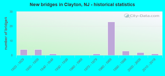
- New bridges - historical statistics
- 41920-1929
- 41930-1939
- 11940-1949
- 11970-1979
- 231980-1989
- 31990-1999
- 22000-2009
- 12010-2019
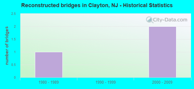
- Reconstructed bridges - Historical Statistics
- 11980-1989
- 01990-1999
- 22000-2009
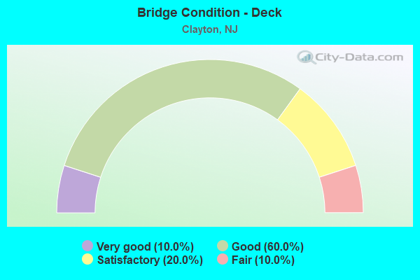
- Bridge Condition - Deck
- 10.0%Very good
- 60.0%Good
- 20.0%Satisfactory
- 10.0%Fair
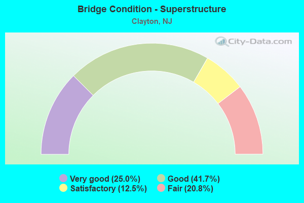
- Bridge Condition - Superstructure
- 25.0%Very good
- 41.7%Good
- 12.5%Satisfactory
- 20.8%Fair
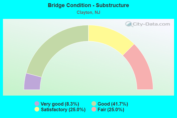
- Bridge Condition - Substructure
- 8.3%Very good
- 41.7%Good
- 25.0%Satisfactory
- 25.0%Fair
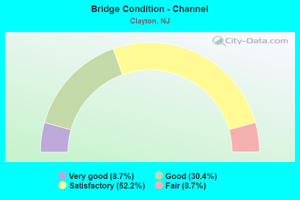
- Bridge Condition - Channel
- 8.7%Very good
- 30.4%Good
- 52.2%Satisfactory
- 8.7%Fair
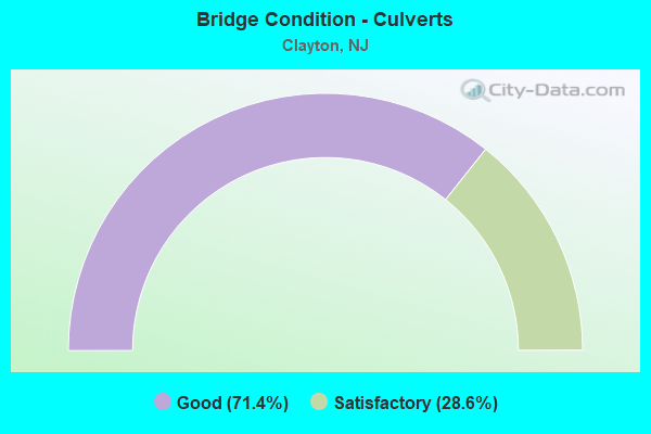
- Bridge Condition - Culverts
- 71.4%Good
- 28.6%Satisfactory
Find on map >> Show street view
Structure Number: 808J01, Location: 0.4 MI NORTH OF CR 608 (Lat: 39.662050, Lng: -75.120989), Route carried "on" structure: County highway 553, Year Built: 1927, Year Reconstructed: 2013, Status: Open, Structure Length: 0.79m (2.59ft), Average Daily Traffic: 7,248 (year 2020), Truck Traffic: 4%, Average Future Daily Traffic: 8,698 (year 2040), Features Intersected: STILL RUN
Minimum Vertical Clearance: 30+ m (98+ ft), Kilometerpoint: 60.157, Lanes on structure: 2, Owner: County Highway Agency, Approaching Roadway Width: 9.1m (29.9ft), Material/Design: Concrete, Design/Construction: Frame, Number Of Spans In Main Unit: 1, Length of Maximum Span: 7.3m (24.0ft), Curb-To-Curb Width: 9.2m (30.2ft), Out-to-Out Width: 10.0m (32.8ft)
Condition: Superstructure: Satisfactory, Substructure: Fair, Channel: Good, Operating Rating: 39.0 metric tons, Method Used To Determine Operating Rating: Field evaluation and documented engineering judgment, Inventory Rating: 23.6 metric tons, Method Used To Determine Inventory Rating: Field evaluation and documented engineering judgment, Structural Evaluation: Somewhat better than minimum adequacy, Deck Geometry: High priority of corrective action, Waterway Adequacy: Equal to present minimum criteria, Approach Roadway Alignment: Equal to present desirable criteria, Length Of Structure Improvement: 0.79m (2.59ft), Designated Inspection Frequency: Every 24 months, Inspection Date: May 2020, Bridge Improvement Cost: $166,000, Roadway Improvement Cost: $100,000, Total Project Cost: $504,000 ( Estimate for 2020)
Find on map >> Show street view
Structure Number: 808K01, Location: 1.34 MI EAST OF RT NJ 47 (Lat: 39.659200, Lng: -75.067619), Route carried "on" structure: County highway 610, Year Built: 1982, Status: Open, Structure Length: 1.25m (4.10ft), Average Daily Traffic: 7,468 (year 2020), Truck Traffic: 4%, Average Future Daily Traffic: 8,962 (year 2040), Design Load: HS 20, Features Intersected: LITTLE EASE RUN
Minimum Vertical Clearance: 30+ m (98+ ft), Kilometerpoint: 5.713, Lanes on structure: 2, Owner: County Highway Agency, Approaching Roadway Width: 8.5m (27.9ft), Material/Design: Aluminum, Iron, Design/Construction: Culvert, Number Of Spans In Main Unit: 3, Length of Maximum Span: 3.4m (11.2ft)
Condition: Channel: Satisfactory, Culverts: Satisfactory, Operating Rating: 80.7 metric tons, Method Used To Determine Operating Rating: Load Factor (LF), Inventory Rating: 48.1 metric tons, Method Used To Determine Inventory Rating: Load Factor (LF), Structural Evaluation: Equal to present minimum criteria, Waterway Adequacy: Equal to present desirable criteria, Approach Roadway Alignment: Equal to present desirable criteria, Designated Inspection Frequency: Every 24 months, Inspection Date: May 2020
Find on map >> Show street view
Structure Number: 808K03, Location: 0.6 mi WEST of CR 655 (Lat: 39.651139, Lng: -75.068250), Route carried "on" structure: City street , Year Built: 1930, Status: Open, Structure Length: 0.79m (2.59ft), Average Daily Traffic: 1,688 (year 2020), Truck Traffic: 1%, Average Future Daily Traffic: 2,026 (year 2040), Features Intersected: LITTLE EASE RUN, Facility Carried by Structure: WASHINGTON AVENUE
Minimum Vertical Clearance: 30+ m (98+ ft), Kilometerpoint: 0.000, Lanes on structure: 2, Owner: County Highway Agency, Approaching Roadway Width: 7.6m (24.9ft), Material/Design: Concrete, Design/Construction: Frame, Number Of Spans In Main Unit: 1, Length of Maximum Span: 6.7m (22.0ft), Curb-To-Curb Width: 9.1m (29.9ft), Out-to-Out Width: 9.9m (32.5ft)
Condition: Deck: Satisfactory, Superstructure: Satisfactory, Substructure: Satisfactory, Channel: Fair, Operating Rating: 49.9 metric tons, Method Used To Determine Operating Rating: Field evaluation and documented engineering judgment, Inventory Rating: 29.9 metric tons, Method Used To Determine Inventory Rating: Field evaluation and documented engineering judgment, Structural Evaluation: Equal to present minimum criteria, Deck Geometry: Somewhat better than minimum adequacy, Waterway Adequacy: Somewhat better than minimum adequacy, Approach Roadway Alignment: Equal to present desirable criteria, Designated Inspection Frequency: Every 24 months, Underwater Inspection Frequency: Every 48 months, Inspection Date: May 2020, Underwater Inspection Date: May 2020, Deck Structure Type: Concrete Cast-file-Place, Wearing Surface/Protective System: Wearing Surface: Bituminous
Find on map >> Show street view
Structure Number: 808K06, Location: 0.75 MI EAST of NJ RT 47 (Lat: 39.634939, Lng: -75.072119), Route carried "on" structure: City street , Year Built: 2011, Status: Open, Structure Length: 1.22m (4.00ft), Average Daily Traffic: 318 (year 2020), Truck Traffic: 1%, Average Future Daily Traffic: 382 (year 2040), Design Load: HS 25 or greater, Features Intersected: LITTLE EASE RUN, Facility Carried by Structure: GRANT AVENUE
Minimum Vertical Clearance: 30+ m (98+ ft), Kilometerpoint: 0.000, Lanes on structure: 2, Owner: County Highway Agency, Approaching Roadway Width: 8.8m (28.9ft), Material/Design: Wood or Timber, Design/Construction: Slab, Number Of Spans In Main Unit: 2, Length of Maximum Span: 5.5m (18.0ft), Curb-To-Curb Width: 8.7m (28.5ft), Out-to-Out Width: 9.3m (30.5ft)
Condition: Deck: Good, Superstructure: Good, Substructure: Good, Channel: Good, Operating Rating: 85.3 metric tons, Method Used To Determine Operating Rating: Allowable Stress (AS), Inventory Rating: 63.5 metric tons, Method Used To Determine Inventory Rating: Allowable Stress (AS), Structural Evaluation: Better than present minimum criteria, Deck Geometry: Equal to present minimum criteria, Waterway Adequacy: Better than present minimum criteria, Approach Roadway Alignment: Equal to present desirable criteria, Designated Inspection Frequency: Every 24 months, Inspection Date: May 2020, Deck Structure Type: Wood or Timber, Wearing Surface/Protective System: Wearing Surface: Bituminous, Membrane: Epoxy
Find on map >> Show street view
Structure Number: 808L01, Location: 0.21 Mi. East of CR 655 (Lat: 39.655911, Lng: -75.051000), Route carried "on" structure: County highway 610, Year Built: 1931, Year Reconstructed: 2013, Status: Open, Structure Length: 0.91m (2.99ft), Average Daily Traffic: 7,468 (year 2020), Truck Traffic: 4%, Average Future Daily Traffic: 8,962 (year 2040), Features Intersected: SCOTLAND RUN @ WILSON LK
Minimum Vertical Clearance: 30+ m (98+ ft), Kilometerpoint: 7.178, Lanes on structure: 2, Owner: County Highway Agency, Approaching Roadway Width: 9.1m (29.9ft), Material/Design: Concrete, Design/Construction: Culvert, Number Of Spans In Main Unit: 1, Length of Maximum Span: 7.3m (24.0ft), Curb or Sidewalk Widths: Left: 1.1m (3.6ft), Right: 1.2m (3.9ft), Curb-To-Curb Width: 9.1m (29.9ft), Out-to-Out Width: 13.0m (42.7ft)
Condition: Channel: Good, Culverts: Good, Operating Rating: 52.6 metric tons, Method Used To Determine Operating Rating: Field evaluation and documented engineering judgment, Inventory Rating: 31.8 metric tons, Method Used To Determine Inventory Rating: Field evaluation and documented engineering judgment, Structural Evaluation: Better than present minimum criteria, Deck Geometry: High priority of corrective action, Waterway Adequacy: Better than present minimum criteria, Approach Roadway Alignment: Equal to present desirable criteria, Length Of Structure Improvement: 0.91m (2.99ft), Designated Inspection Frequency: Every 24 months, Inspection Date: May 2020, Bridge Improvement Cost: $83,000, Roadway Improvement Cost: $100,000, Total Project Cost: $390,000 ( Estimate for 2020)
Find on map >> Show street view
Structure Number: 808L02, Location: 0.25 mi East of CR 655 (Lat: 39.645100, Lng: -75.052581), Route carried "on" structure: Other road , Year Built: 2006, Status: Open, Structure Length: 0.82m (2.69ft), Average Daily Traffic: 1,061 (year 2020), Truck Traffic: 3%, Average Future Daily Traffic: 1,273 (year 2040), Design Load: HS 20, Features Intersected: SCOTLAND RUN, Facility Carried by Structure: WASHINGTON AVENUE
Minimum Vertical Clearance: 30+ m (98+ ft), Kilometerpoint: 0.000, Lanes on structure: 2, Owner: County Highway Agency, Approaching Roadway Width: 9.8m (32.2ft), Material/Design: Wood or Timber, Design/Construction: Slab, Number Of Spans In Main Unit: 1, Length of Maximum Span: 7.6m (24.9ft), Curb-To-Curb Width: 9.8m (32.2ft), Out-to-Out Width: 10.3m (33.8ft)
Condition: Deck: Good, Superstructure: Good, Substructure: Good, Channel: Satisfactory, Inventory Rating: 79.8 metric tons, Method Used To Determine Inventory Rating: Allowable Stress (AS), Structural Evaluation: Better than present minimum criteria, Deck Geometry: Somewhat better than minimum adequacy, Waterway Adequacy: Equal to present desirable criteria, Approach Roadway Alignment: Equal to present desirable criteria, Designated Inspection Frequency: Every 24 months, Inspection Date: May 2020, Deck Structure Type: Wood or Timber, Wearing Surface/Protective System: Wearing Surface: Bituminous
Find on map >> Show street view
Structure Number: 808L04, Location: 0.35 mi East of CR 655 (Lat: 39.634761, Lng: -75.055389), Route carried "on" structure: City street , Year Built: 1938, Status: Open, Structure Length: 0.85m (2.79ft), Average Daily Traffic: 318 (year 2020), Truck Traffic: 1%, Average Future Daily Traffic: 382 (year 2040), Features Intersected: SCOTLAND RUN, Facility Carried by Structure: GRANT AVENUE
Minimum Vertical Clearance: 30+ m (98+ ft), Kilometerpoint: 0.000, Lanes on structure: 2, Owner: County Highway Agency, Approaching Roadway Width: 6.4m (21.0ft), Material/Design: Concrete, Design/Construction: Frame, Number Of Spans In Main Unit: 1, Length of Maximum Span: 7.3m (24.0ft), Curb-To-Curb Width: 9.1m (29.9ft), Out-to-Out Width: 9.9m (32.5ft)
Condition: Deck: Fair, Superstructure: Fair, Substructure: Fair, Channel: Satisfactory, Operating Rating: 48.1 metric tons, Method Used To Determine Operating Rating: Field evaluation and documented engineering judgment, Inventory Rating: 29.0 metric tons, Method Used To Determine Inventory Rating: Field evaluation and documented engineering judgment, Structural Evaluation: Somewhat better than minimum adequacy, Deck Geometry: Equal to present minimum criteria, Waterway Adequacy: Equal to present minimum criteria, Approach Roadway Alignment: Equal to present desirable criteria, Designated Inspection Frequency: Every 24 months, Inspection Date: May 2020, Deck Structure Type: Concrete Cast-file-Place, Wearing Surface/Protective System: Wearing Surface: Bituminous
Find on map >> Show street view
Structure Number: 809J01, Location: 2.24 mi North of US RT 40 (Lat: 39.628000, Lng: -75.126169), Route carried "on" structure: County highway 553, Year Built: 1996, Status: Open, Structure Length: 0.64m (2.10ft), Average Daily Traffic: 7,248 (year 2020), Truck Traffic: 3%, Average Future Daily Traffic: 8,698 (year 2040), Design Load: HS 20+Mod, Features Intersected: REED BR AT GARRISON LAKE
Minimum Vertical Clearance: 30+ m (98+ ft), Kilometerpoint: 56.359, Lanes on structure: 2, Owner: County Highway Agency, Approaching Roadway Width: 12.2m (40.0ft), Material/Design: Concrete, Design/Construction: Culvert, Number Of Spans In Main Unit: 2, Length of Maximum Span: 3.0m (9.8ft), Curb-To-Curb Width: 12.2m (40.0ft), Out-to-Out Width: 13.4m (44.0ft)
Condition: Channel: Satisfactory, Culverts: Good, Operating Rating: 46.3 metric tons, Method Used To Determine Operating Rating: Load Factor (LF), Inventory Rating: 27.2 metric tons, Method Used To Determine Inventory Rating: Load Factor (LF), Structural Evaluation: Equal to present minimum criteria, Deck Geometry: Somewhat better than minimum adequacy, Waterway Adequacy: Equal to present desirable criteria, Approach Roadway Alignment: Equal to present desirable criteria, Designated Inspection Frequency: Every 24 months, Inspection Date: April 2020
Find on map >> Show street view
Structure Number: 809J02, Location: .25 MI N OF JCT CR 604 (Lat: 39.625589, Lng: -75.112489), Route carried "on" structure: Other road , Year Built: 1991, Status: Open, Structure Length: 0.98m (3.22ft), Average Daily Traffic: 1,678 (year 2020), Truck Traffic: 3%, Average Future Daily Traffic: 2,014 (year 2040), Features Intersected: REED BRANCH, Facility Carried by Structure: WILLOW GROVE ROAD
Minimum Vertical Clearance: 30+ m (98+ ft), Kilometerpoint: 0.000, Lanes on structure: 2, Owner: County Highway Agency, Approaching Roadway Width: 10.4m (34.1ft), Material/Design: Prestressed concrete, Design/Construction: Box Beam or Girders - Multiple, Number Of Spans In Main Unit: 1, Length of Maximum Span: 8.5m (27.9ft), Curb-To-Curb Width: 10.4m (34.1ft), Out-to-Out Width: 11.4m (37.4ft)
Condition: Deck: Satisfactory, Superstructure: Good, Substructure: Good, Channel: Satisfactory, Inventory Rating: 81.6 metric tons, Method Used To Determine Inventory Rating: Load Factor (LF), Structural Evaluation: Better than present minimum criteria, Deck Geometry: Equal to present minimum criteria, Waterway Adequacy: Equal to present minimum criteria, Approach Roadway Alignment: Equal to present desirable criteria, Designated Inspection Frequency: Every 24 months, Inspection Date: April 2020, Deck Structure Type: Concrete Cast-file-Place, Wearing Surface/Protective System: Wearing Surface: Monolithic Concrete, Deck Protection: Epoxy Coated Reinforcing
Find on map >> Show street view
Structure Number: 809J03, Location: 0.7 Mi West of RT 538 (Lat: 39.620289, Lng: -75.104500), Route carried "on" structure: County highway 604, Year Built: 1928, Status: Open, Structure Length: 0.76m (2.49ft), Average Daily Traffic: 2,197 (year 2020), Truck Traffic: 3%, Average Future Daily Traffic: 2,636 (year 2040), Features Intersected: REED BRANCH
Minimum Vertical Clearance: 30+ m (98+ ft), Kilometerpoint: 3.203, Lanes on structure: 2, Owner: County Highway Agency, Approaching Roadway Width: 7.3m (24.0ft), Material/Design: Concrete, Design/Construction: Frame, Number Of Spans In Main Unit: 1, Length of Maximum Span: 6.1m (20.0ft), Curb-To-Curb Width: 8.1m (26.6ft), Out-to-Out Width: 10.1m (33.1ft)
Condition: Superstructure: Fair, Substructure: Fair, Channel: Satisfactory, Operating Rating: 34.5 metric tons, Method Used To Determine Operating Rating: Field evaluation and documented engineering judgment, Inventory Rating: 20.0 metric tons, Method Used To Determine Inventory Rating: Field evaluation and documented engineering judgment, Structural Evaluation: Somewhat better than minimum adequacy, Deck Geometry: High priority of corrective action, Waterway Adequacy: Equal to present minimum criteria, Approach Roadway Alignment: Equal to present desirable criteria, Length Of Structure Improvement: 0.76m (2.49ft), Designated Inspection Frequency: Every 24 months, Underwater Inspection Frequency: Every 24 months, Inspection Date: May 2020, Underwater Inspection Date: May 2020, Bridge Improvement Cost: $42,000, Roadway Improvement Cost: $200,000, Total Project Cost: $361,000 ( Estimate for 2020)
Find on map >> Show street view
Structure Number: 809K02, Location: 0.1 Mi East OF NJ RT 47 (Lat: 39.617500, Lng: -75.079431), Route carried "on" structure: County highway 538, Year Built: 1923, Status: Open, Structure Length: 0.91m (2.99ft), Average Daily Traffic: 6,800 (year 2020), Truck Traffic: 4%, Average Future Daily Traffic: 8,160 (year 2040), Features Intersected: LITTLE EASE RUN
Minimum Vertical Clearance: 30+ m (98+ ft), Kilometerpoint: 25.041, Lanes on structure: 2, Owner: County Highway Agency, Approaching Roadway Width: 9.2m (30.2ft), Material/Design: Concrete, Design/Construction: Frame, Number Of Spans In Main Unit: 1, Length of Maximum Span: 7.3m (24.0ft), Curb-To-Curb Width: 9.2m (30.2ft), Out-to-Out Width: 10.0m (32.8ft)
Condition: Superstructure: Fair, Substructure: Fair, Channel: Satisfactory, Operating Rating: 46.3 metric tons, Method Used To Determine Operating Rating: Field evaluation and documented engineering judgment, Inventory Rating: 27.2 metric tons, Method Used To Determine Inventory Rating: Field evaluation and documented engineering judgment, Structural Evaluation: Somewhat better than minimum adequacy, Deck Geometry: High priority of corrective action, Waterway Adequacy: Somewhat better than minimum adequacy, Approach Roadway Alignment: Equal to present desirable criteria, Length Of Structure Improvement: 0.91m (2.99ft), Designated Inspection Frequency: Every 24 months, Inspection Date: April 2020, Bridge Improvement Cost: $174,000, Roadway Improvement Cost: $200,000, Total Project Cost: $586,000 ( Estimate for 2020)
Find on map >> Show street view
Structure Number: 809K05, Location: 1.2M.N.RT 40&0.2M W RT 55 (Lat: 39.609000, Lng: -75.089450), Route carried "on" structure: City street , Year Built: 1941, Year Reconstructed: 1992, Status: Open, Structure Length: 0.94m (3.08ft), Average Daily Traffic: 1,345 (year 2020), Truck Traffic: 1%, Average Future Daily Traffic: 1,614 (year 2040), Design Load: HS 20, Features Intersected: REEDS BRANCH, Facility Carried by Structure: ROYAL AVENUE
Minimum Vertical Clearance: 30+ m (98+ ft), Kilometerpoint: 0.000, Lanes on structure: 2, Owner: County Highway Agency, Approaching Roadway Width: 7.3m (24.0ft), Material/Design: Wood or Timber, Design/Construction: Slab, Number Of Spans In Main Unit: 2, Length of Maximum Span: 4.6m (15.1ft), Curb-To-Curb Width: 9.0m (29.5ft), Out-to-Out Width: 10.0m (32.8ft)
Condition: Deck: Good, Superstructure: Good, Substructure: Good, Channel: Satisfactory, Operating Rating: 75.3 metric tons, Method Used To Determine Operating Rating: Allowable Stress (AS), Inventory Rating: 54.4 metric tons, Method Used To Determine Inventory Rating: Allowable Stress (AS), Structural Evaluation: Better than present minimum criteria, Deck Geometry: Somewhat better than minimum adequacy, Waterway Adequacy: Better than present minimum criteria, Approach Roadway Alignment: Better than present minimum criteria, Designated Inspection Frequency: Every 24 months, Underwater Inspection Frequency: Every 48 months, Inspection Date: October 2020, Underwater Inspection Date: November 2018, Deck Structure Type: Wood or Timber, Wearing Surface/Protective System: Wearing Surface: Bituminous, Membrane: Preformed Fabric
Find on map >> Show street view
Structure Number: 809K06, Location: 0.4 MI N OF TAYLOR ROAD (Lat: 39.601089, Lng: -75.100119), Route carried "on" structure: Other road , Year Built: 1935, Status: Open, Structure Length: 0.79m (2.59ft), Average Daily Traffic: 1,678 (year 2020), Truck Traffic: 3%, Average Future Daily Traffic: 2,014 (year 2040), Features Intersected: TRIBUTARY TO STILL RUN, Facility Carried by Structure: WILLOW GROVE RD
Minimum Vertical Clearance: 30+ m (98+ ft), Kilometerpoint: 0.000, Lanes on structure: 2, Owner: County Highway Agency, Approaching Roadway Width: 8.5m (27.9ft), Skew: 3 degrees, Material/Design: Concrete, Design/Construction: Frame, Number Of Spans In Main Unit: 1, Length of Maximum Span: 6.4m (21.0ft), Curb-To-Curb Width: 9.0m (29.5ft), Out-to-Out Width: 10.2m (33.5ft)
Condition: Superstructure: Fair, Substructure: Fair, Channel: Satisfactory, Operating Rating: 52.6 metric tons, Method Used To Determine Operating Rating: Field evaluation and documented engineering judgment, Inventory Rating: 31.8 metric tons, Method Used To Determine Inventory Rating: Field evaluation and documented engineering judgment, Structural Evaluation: Somewhat better than minimum adequacy, Deck Geometry: Somewhat better than minimum adequacy, Waterway Adequacy: Equal to present minimum criteria, Approach Roadway Alignment: Equal to present desirable criteria, Designated Inspection Frequency: Every 24 months, Inspection Date: May 2020
Find on map >> Show street view
Structure Number: 809L01, Location: 1.0 mi NORTH of NJ RT 47 (Lat: 39.620600, Lng: -75.061950), Route carried "on" structure: City street , Year Built: 1997, Status: Open, Structure Length: 0.91m (2.99ft), Average Daily Traffic: 1,324 (year 2020), Truck Traffic: 1%, Average Future Daily Traffic: 1,589 (year 2040), Design Load: HS 25 or greater, Features Intersected: SCOTLAND RUN, Facility Carried by Structure: FRANKLN-WILLMTN RD
Minimum Vertical Clearance: 30+ m (98+ ft), Kilometerpoint: 0.000, Lanes on structure: 2, Owner: County Highway Agency, Approaching Roadway Width: 9.1m (29.9ft), Skew: 1 degrees, Material/Design: Prestressed concrete, Design/Construction: Slab, Number Of Spans In Main Unit: 1, Length of Maximum Span: 7.6m (24.9ft), Curb-To-Curb Width: 9.1m (29.9ft), Out-to-Out Width: 10.4m (34.1ft)
Condition: Deck: Satisfactory, Superstructure: Very good, Substructure: Very good, Channel: Satisfactory, Inventory Rating: 80.7 metric tons, Method Used To Determine Inventory Rating: Load Factor (LF), Structural Evaluation: Equal to present desirable criteria, Deck Geometry: Somewhat better than minimum adequacy, Waterway Adequacy: Better than present minimum criteria, Approach Roadway Alignment: Equal to present desirable criteria, Designated Inspection Frequency: Every 24 months, Inspection Date: April 2020, Deck Structure Type: Concrete Cast-file-Place, Wearing Surface/Protective System: Wearing Surface: Monolithic Concrete, Deck Protection: Epoxy Coated Reinforcing
Find on map >> Show street view
Structure Number: 809L02, Location: 1.17 Mi East of Rte 47 (Lat: 39.618261, Lng: -75.059439), Route carried "on" structure: County highway 538, Year Built: 2008, Status: Open, Structure Length: 0.64m (2.10ft), Average Daily Traffic: 4,261 (year 2020), Truck Traffic: 3%, Average Future Daily Traffic: 5,113 (year 2040), Features Intersected: SCOTLAND RUN, Facility Carried by Structure: COLES MILL ROAD
Minimum Vertical Clearance: 30+ m (98+ ft), Kilometerpoint: 26.812, Lanes on structure: 2, Owner: County Highway Agency, Approaching Roadway Width: 13.4m (44.0ft), Skew: 1 degrees, Material/Design: Concrete, Design/Construction: Frame, Number Of Spans In Main Unit: 1, Length of Maximum Span: 6.4m (21.0ft), Curb-To-Curb Width: 13.4m (44.0ft), Out-to-Out Width: 14.5m (47.6ft)
Condition: Deck: Very good, Superstructure: Very good, Substructure: Very good, Channel: Good, Operating Rating: 59.0 metric tons, Method Used To Determine Operating Rating: Field evaluation and documented engineering judgment, Inventory Rating: 35.4 metric tons, Method Used To Determine Inventory Rating: Field evaluation and documented engineering judgment, Structural Evaluation: Equal to present desirable criteria, Deck Geometry: Better than present minimum criteria, Waterway Adequacy: Equal to present desirable criteria, Approach Roadway Alignment: Equal to present desirable criteria, Designated Inspection Frequency: Every 24 months, Inspection Date: October 2020, Deck Structure Type: Concrete Precast Panels, Wearing Surface/Protective System: Wearing Surface: Bituminous, Deck Protection: Epoxy Coated Reinforcing
Find on map >> Show street view
Structure Number: 82615, Location: 0.6 MI E OF CR 655 (Lat: 39.693061, Lng: -75.040800), Route carried "on" structure: US 322, Year Built: 1970, Status: Open, Structure Length: 0.85m (2.79ft), Average Daily Traffic: 9,952 (year 2020), Truck Traffic: 4%, Average Future Daily Traffic: 12,143 (year 2040), Design Load: HS 20, Features Intersected: SCOTLAND RUN
Minimum Vertical Clearance: 30+ m (98+ ft), Kilometerpoint: 35.068, Lanes on structure: 2, Base Highway Network: Yes, Owner: State Highway Agency, Approaching Roadway Width: 15.2m (49.9ft), Material/Design: Concrete, Design/Construction: Slab, Number Of Spans In Main Unit: 1, Length of Maximum Span: 8.2m (26.9ft), Curb or Sidewalk Widths: Left: 1.8m (5.9ft), Right: 1.8m (5.9ft), Curb-To-Curb Width: 15.2m (49.9ft), Out-to-Out Width: 19.5m (64.0ft)
Condition: Deck: Satisfactory, Superstructure: Satisfactory, Substructure: Satisfactory, Channel: Satisfactory, Operating Rating: 76.2 metric tons, Method Used To Determine Operating Rating: Load Factor (LF), Inventory Rating: 45.4 metric tons, Method Used To Determine Inventory Rating: Load Factor (LF), Structural Evaluation: Equal to present minimum criteria, Deck Geometry: Superior to present desirable criteria, Waterway Adequacy: Superior to present desirable criteria, Approach Roadway Alignment: Equal to present desirable criteria, Length Of Structure Improvement: 1.46m (4.79ft), Designated Inspection Frequency: Every 24 months, Inspection Date: September 2020, Bridge Improvement Cost: $356,000, Total Project Cost: $356,000 ( Estimate for 2020), Deck Structure Type: Concrete Cast-file-Place, Wearing Surface/Protective System: Wearing Surface: Monolithic Concrete
Find on map >> Show street view
Structure Number: 828158, Location: 1.58 MI SOUTH OF EXIT 43 (Lat: 39.615589, Lng: -75.084700), Route carried "on" structure: City street , Year Built: 1987, Status: Open, Structure Length: 7.22m (23.69ft), Average Daily Traffic: 1,606 (year 2021), Truck Traffic: 1%, Average Future Daily Traffic: 1,923 (year 2041), Design Load: HS 20+Mod, Features Intersected: NJ 55, Facility Carried by Structure: ROYAL AVENUE
Minimum Vertical Clearance: 30+ m (98+ ft), Kilometerpoint: 0.000, Lanes on structure: 2, Lanes under structure: 4, Owner: State Highway Agency, Approaching Roadway Width: 9.1m (29.9ft), Material/Design: Steel, Design/Construction: Stringer/Multi-beam, Number Of Spans In Main Unit: 2, Length of Maximum Span: 35.1m (115.2ft), Curb or Sidewalk Widths: Left: 0.0m, Right: 1.8m (5.9ft), Curb-To-Curb Width: 9.1m (29.9ft), Out-to-Out Width: 11.9m (39.0ft)
Condition: Deck: Good, Superstructure: Very good, Substructure: Good, Inventory Rating: 76.2 metric tons, Method Used To Determine Inventory Rating: Load Factor (LF), Structural Evaluation: Better than present minimum criteria, Deck Geometry: Somewhat better than minimum adequacy, Underclear: Better than present minimum criteria, Approach Roadway Alignment: Better than present minimum criteria, Designated Inspection Frequency: Every 24 months, Inspection Date: June 2021, Deck Structure Type: Concrete Cast-file-Place, Wearing Surface/Protective System: Wearing Surface: Latex Concrete, Deck Protection: Epoxy Coated Reinforcing
Find on map >> Show street view
Structure Number: 828159, Location: 0.88MILE NO.OF CO.RT.613 (Lat: 39.615031, Lng: -75.086081), Route carried "on" structure: City street , Year Built: 1987, Status: Open, Structure Length: 1.10m (3.61ft), Average Daily Traffic: 3,835 (year 2016), Truck Traffic: 1%, Average Future Daily Traffic: 4,590 (year 2036), Design Load: HS 20+Mod, Features Intersected: STILL RUN, Facility Carried by Structure: ROYAL AVENUE
Minimum Vertical Clearance: 30+ m (98+ ft), Kilometerpoint: 67.464, Lanes on structure: 2, Owner: State Highway Agency, Approaching Roadway Width: 9.1m (29.9ft), Skew: 4 degrees, Material/Design: Concrete, Design/Construction: Culvert, Number Of Spans In Main Unit: 2, Length of Maximum Span: 5.5m (18.0ft)
Condition: Channel: Very good, Culverts: Good, Operating Rating: 46.3 metric tons, Method Used To Determine Operating Rating: Load Factor (LF), Inventory Rating: 27.2 metric tons, Method Used To Determine Inventory Rating: Load Factor (LF), Structural Evaluation: Equal to present minimum criteria, Waterway Adequacy: Superior to present desirable criteria, Approach Roadway Alignment: Better than present minimum criteria, Designated Inspection Frequency: Every 24 months, Inspection Date: March 2020
Find on map >> Show street view
Structure Number: 82816, Location: 2.85ML N.OF RT 40 INTCH. (Lat: 39.619800, Lng: -75.087861), Route carried "on" structure: State highway 55, Year Built: 1987, Status: Open, Structure Length: 4.24m (13.91ft), Average Daily Traffic: 22,313 (year 2020), Truck Traffic: 5%, Average Future Daily Traffic: 27,226 (year 2040), Design Load: HS 20, Features Intersected: SWEDESBORO ROAD (CR 538)
Minimum Vertical Clearance: 30+ m (98+ ft), Kilometerpoint: 68.043, Lanes on structure: 2, Lanes under structure: 2, Base Highway Network: Yes, Owner: State Highway Agency, Approaching Roadway Width: 13.4m (44.0ft), Skew: 3 degrees, Material/Design: Steel, Design/Construction: Stringer/Multi-beam, Number Of Spans In Main Unit: 1, Length of Maximum Span: 41.5m (136.2ft), Curb-To-Curb Width: 13.4m (44.0ft), Out-to-Out Width: 14.5m (47.6ft)
Condition: Deck: Good, Superstructure: Good, Substructure: Satisfactory, Inventory Rating: 69.9 metric tons, Method Used To Determine Inventory Rating: Load Factor (LF), Structural Evaluation: Equal to present minimum criteria, Deck Geometry: Superior to present desirable criteria, Underclear: Superior to present desirable criteria, Approach Roadway Alignment: Equal to present desirable criteria, Designated Inspection Frequency: Every 24 months, Inspection Date: April 2020, Deck Structure Type: Concrete Cast-file-Place, Wearing Surface/Protective System: Wearing Surface: Monolithic Concrete, Deck Protection: Epoxy Coated Reinforcing
Find on map >> Show street view
Structure Number: 828161, Location: 2.92 Mi N.OF US 40 (Lat: 39.620100, Lng: -75.088700), Route carried "on" structure: State highway 55, Year Built: 1987, Status: Open, Structure Length: 4.02m (13.19ft), Average Daily Traffic: 17,482 (year 2021), Truck Traffic: 5%, Average Future Daily Traffic: 21,330 (year 2041), Design Load: HS 20+Mod, Features Intersected: SWEDESBORO RD (CR 538)
Minimum Vertical Clearance: 30+ m (98+ ft), Kilometerpoint: 68.043, Lanes on structure: 2, Lanes under structure: 2, Base Highway Network: Yes, Owner: State Highway Agency, Approaching Roadway Width: 13.4m (44.0ft), Skew: 3 degrees, Material/Design: Steel, Design/Construction: Stringer/Multi-beam, Number Of Spans In Main Unit: 1, Length of Maximum Span: 39.3m (128.9ft), Curb-To-Curb Width: 13.4m (44.0ft), Out-to-Out Width: 14.4m (47.2ft)
Condition: Deck: Good, Superstructure: Very good, Substructure: Satisfactory, Inventory Rating: 59.0 metric tons, Method Used To Determine Inventory Rating: Load Factor (LF), Structural Evaluation: Equal to present minimum criteria, Deck Geometry: Superior to present desirable criteria, Underclear: Better than present minimum criteria, Approach Roadway Alignment: Equal to present desirable criteria, Designated Inspection Frequency: Every 24 months, Inspection Date: December 2021, Deck Structure Type: Concrete Cast-file-Place, Wearing Surface/Protective System: Wearing Surface: Monolithic Concrete, Deck Protection: Epoxy Coated Reinforcing
Find on map >> Show street view
Structure Number: 828162, Location: 0.08mi W. of NJ55 (Lat: 39.619739, Lng: -75.089531), Route carried "on" structure: County highway 538, Year Built: 1986, Status: Open, Structure Length: 1.65m (5.41ft), Average Daily Traffic: 2,829 (year 2020), Truck Traffic: 3%, Average Future Daily Traffic: 3,452 (year 2040), Design Load: HS 20+Mod, Features Intersected: STILL RUN
Minimum Vertical Clearance: 30+ m (98+ ft), Kilometerpoint: 24.156, Lanes on structure: 2, Owner: State Highway Agency, Approaching Roadway Width: 12.2m (40.0ft), Skew: 5 degrees, Material/Design: Concrete, Design/Construction: Culvert, Number Of Spans In Main Unit: 2, Length of Maximum Span: 7.9m (25.9ft)
Condition: Channel: Good, Culverts: Good, Operating Rating: 89.8 metric tons, Method Used To Determine Operating Rating: Load Factor (LF), Inventory Rating: 72.6 metric tons, Method Used To Determine Inventory Rating: Load Factor (LF), Structural Evaluation: Better than present minimum criteria, Waterway Adequacy: Equal to present desirable criteria, Approach Roadway Alignment: Equal to present desirable criteria, Designated Inspection Frequency: Every 24 months, Inspection Date: April 2020
Find on map >> Show street view
Structure Number: 828165, Location: 4.1ML N OF RT 40 INTCH. (Lat: 39.636211, Lng: -75.096419), Route carried "on" structure: City street , Year Built: 1987, Status: Open, Structure Length: 7.71m (25.30ft), Average Daily Traffic: 1,683 (year 2021), Truck Traffic: 1%, Average Future Daily Traffic: 2,057 (year 2041), Design Load: HS 20+Mod, Features Intersected: RT. NJ 55, Facility Carried by Structure: LITTLE MILL ROAD
Minimum Vertical Clearance: 30+ m (98+ ft), Kilometerpoint: 1.915, Lanes on structure: 4, Lanes under structure: 4, Owner: State Highway Agency, Approaching Roadway Width: 15.2m (49.9ft), Skew: 1 degrees, Material/Design: Steel, Design/Construction: Stringer/Multi-beam, Number Of Spans In Main Unit: 2, Length of Maximum Span: 37.5m (123.0ft), Curb or Sidewalk Widths: Left: 1.8m (5.9ft), Right: 1.8m (5.9ft), Curb-To-Curb Width: 15.2m (49.9ft), Out-to-Out Width: 19.5m (64.0ft)
Condition: Deck: Good, Superstructure: Good, Substructure: Satisfactory, Inventory Rating: 75.3 metric tons, Method Used To Determine Inventory Rating: Load Factor (LF), Structural Evaluation: Equal to present minimum criteria, Deck Geometry: High priority of corrective action, Underclear: Better than present minimum criteria, Approach Roadway Alignment: Equal to present desirable criteria, Length Of Structure Improvement: 7.71m (25.30ft), Designated Inspection Frequency: Every 24 months, Inspection Date: March 2021, Bridge Improvement Cost: $26,000, Roadway Improvement Cost: $5,000, Total Project Cost: $240,000 ( Estimate for 2021), Deck Structure Type: Concrete Cast-file-Place, Wearing Surface/Protective System: Wearing Surface: Latex Concrete, Deck Protection: Epoxy Coated Reinforcing
Find on map >> Show street view
Structure Number: 828166, Location: .25MI.N.OF N.J 55,EXIT.43 (Lat: 39.635661, Lng: -75.099331), Route carried "on" structure: Other road , Year Built: 1987, Status: Open, Structure Length: 0.88m (2.89ft), Average Daily Traffic: 2,209 (year 2022), Truck Traffic: 1%, Average Future Daily Traffic: 3,170 (year 2042), Design Load: HS 20+Mod, Features Intersected: STILL RUN, Facility Carried by Structure: LITTLE MILL RD
Minimum Vertical Clearance: 30+ m (98+ ft), Kilometerpoint: 70.055, Lanes on structure: 4, Owner: State Highway Agency, Approaching Roadway Width: 15.2m (49.9ft), Material/Design: Concrete, Design/Construction: Culvert, Number Of Spans In Main Unit: 2, Length of Maximum Span: 4.3m (14.1ft)
Condition: Channel: Very good, Culverts: Good, Operating Rating: 89.8 metric tons, Method Used To Determine Operating Rating: Load Factor (LF), Inventory Rating: 89.8 metric tons, Method Used To Determine Inventory Rating: Load Factor (LF), Structural Evaluation: Better than present minimum criteria, Waterway Adequacy: Equal to present desirable criteria, Approach Roadway Alignment: Equal to present desirable criteria, Designated Inspection Frequency: Every 24 months, Inspection Date: Febuary 2022
Find on map >> Show street view
Structure Number: 828167, Location: 6.43 MI S OF RT 322 JCT (Lat: 39.643331, Lng: -75.101669), Route carried "on" structure: State highway 55, Year Built: 1988, Status: Open, Structure Length: 3.23m (10.60ft), Average Daily Traffic: 25,786 (year 2021), Truck Traffic: 5%, Average Future Daily Traffic: 31,433 (year 2041), Design Load: HS 20+Mod, Features Intersected: STILL RUN
Minimum Vertical Clearance: 30+ m (98+ ft), Kilometerpoint: 70.924, Lanes on structure: 2, Base Highway Network: Yes, Owner: State Highway Agency, Approaching Roadway Width: 14.3m (46.9ft), Skew: 4 degrees, Material/Design: Steel, Design/Construction: Stringer/Multi-beam, Number Of Spans In Main Unit: 1, Length of Maximum Span: 30.5m (100.1ft), Curb-To-Curb Width: 14.5m (47.6ft), Out-to-Out Width: 15.8m (51.8ft)
Condition: Deck: Good, Superstructure: Good, Substructure: Good, Channel: Fair, Inventory Rating: 78.0 metric tons, Method Used To Determine Inventory Rating: Load Factor (LF), Structural Evaluation: Better than present minimum criteria, Deck Geometry: Superior to present desirable criteria, Waterway Adequacy: Superior to present desirable criteria, Approach Roadway Alignment: Equal to present desirable criteria, Designated Inspection Frequency: Every 24 months, Inspection Date: August 2021, Deck Structure Type: Concrete Cast-file-Place, Wearing Surface/Protective System: Wearing Surface: Monolithic Concrete, Deck Protection: Epoxy Coated Reinforcing
Find on map >> Show street view
Structure Number: 828168, Location: 1.4 MI S. CR553&NJ55 INCH (Lat: 39.642919, Lng: -75.101419), Route carried "on" structure: State highway 55, Year Built: 1988, Status: Open, Structure Length: 3.32m (10.89ft), Average Daily Traffic: 25,786 (year 2021), Truck Traffic: 5%, Average Future Daily Traffic: 31,433 (year 2041), Design Load: HS 20+Mod, Features Intersected: STILL RUN
Minimum Vertical Clearance: 30+ m (98+ ft), Kilometerpoint: 70.924, Lanes on structure: 2, Base Highway Network: Yes, Owner: State Highway Agency, Approaching Roadway Width: 13.4m (44.0ft), Skew: 4 degrees, Material/Design: Steel, Design/Construction: Stringer/Multi-beam, Number Of Spans In Main Unit: 1, Length of Maximum Span: 31.1m (102.0ft), Curb-To-Curb Width: 13.4m (44.0ft), Out-to-Out Width: 14.8m (48.6ft)
Condition: Deck: Good, Superstructure: Good, Substructure: Good, Channel: Good, Structural Evaluation: Better than present minimum criteria, Deck Geometry: Superior to present desirable criteria, Waterway Adequacy: Superior to present desirable criteria, Approach Roadway Alignment: Equal to present desirable criteria, Designated Inspection Frequency: Every 24 months, Inspection Date: August 2021, Deck Structure Type: Concrete Cast-file-Place, Wearing Surface/Protective System: Wearing Surface: Monolithic Concrete, Deck Protection: Epoxy Coated Reinforcing
Find on map >> Show street view
Structure Number: 828169, Location: 0.77 MILES S. OF CO. 553 (Lat: 39.646611, Lng: -75.110100), Route carried "on" structure: City street , Year Built: 1989, Status: Open, Structure Length: 8.20m (26.90ft), Average Daily Traffic: 1,040 (year 2020), Truck Traffic: 1%, Average Future Daily Traffic: 1,270 (year 2040), Design Load: HS 20+Mod, Features Intersected: ROUTE 55, Facility Carried by Structure: CEDAR BRIDGE ROAD
Minimum Vertical Clearance: 30.45m (99.90ft), Kilometerpoint: 0.000, Lanes on structure: 2, Lanes under structure: 4, Owner: State Highway Agency, Approaching Roadway Width: 11.3m (37.1ft), Skew: 1 degrees, Material/Design: Steel continuous, Design/Construction: Stringer/Multi-beam, Number Of Spans In Main Unit: 2, Length of Maximum Span: 40.2m (131.9ft), Curb or Sidewalk Widths: Left: 1.8m (5.9ft), Right: 0.0m, Curb-To-Curb Width: 11.3m (37.1ft), Out-to-Out Width: 13.9m (45.6ft)
Condition: Deck: Good, Superstructure: Good, Substructure: Good, Inventory Rating: 85.3 metric tons, Method Used To Determine Inventory Rating: Load Factor (LF), Structural Evaluation: Better than present minimum criteria, Deck Geometry: Equal to present minimum criteria, Underclear: Equal to present minimum criteria, Approach Roadway Alignment: Equal to present desirable criteria, Designated Inspection Frequency: Every 24 months, Inspection Date: May 2020, Deck Structure Type: Concrete Cast-file-Place, Wearing Surface/Protective System: Wearing Surface: Monolithic Concrete, Deck Protection: Epoxy Coated Reinforcing
Find on map >> Show street view
Structure Number: 82817, Location: 3.87 Miles N. OF US 40 (Lat: 39.651111, Lng: -75.122861), Route carried "on" structure: County highway 553, Year Built: 1989, Status: Open, Structure Length: 8.84m (29.00ft), Average Daily Traffic: 7,673 (year 2021), Truck Traffic: 4%, Average Future Daily Traffic: 9,354 (year 2041), Features Intersected: NJ 55
Minimum Vertical Clearance: 30+ m (98+ ft), Kilometerpoint: 58.950, Lanes on structure: 2, Lanes under structure: 4, Owner: State Highway Agency, Approaching Roadway Width: 17.7m (58.1ft), Skew: 4 degrees, Material/Design: Steel continuous, Design/Construction: Stringer/Multi-beam, Number Of Spans In Main Unit: 2, Length of Maximum Span: 44.2m (145.0ft), Curb or Sidewalk Widths: Left: 1.8m (5.9ft), Right: 1.8m (5.9ft), Curb-To-Curb Width: 17.7m (58.1ft), Out-to-Out Width: 21.9m (71.9ft)
Condition: Deck: Good, Superstructure: Very good, Substructure: Satisfactory, Operating Rating: 86.2 metric tons, Method Used To Determine Operating Rating: Load Factor (LF), Inventory Rating: 51.7 metric tons, Method Used To Determine Inventory Rating: Load Factor (LF), Structural Evaluation: Equal to present minimum criteria, Deck Geometry: Superior to present desirable criteria, Underclear: Equal to present minimum criteria, Approach Roadway Alignment: Equal to present desirable criteria, Designated Inspection Frequency: Every 24 months, Inspection Date: November 2021, Deck Structure Type: Concrete Cast-file-Place, Wearing Surface/Protective System: Wearing Surface: Monolithic Concrete, Deck Protection: Epoxy Coated Reinforcing
Find on map >> Show street view
Structure Number: 828171, Location: 0.1 MI S OF CR 553 (Lat: 39.651361, Lng: -75.121531), Route carried "on" structure: Ramp State highway 55, Year Built: 1989, Status: Open, Structure Length: 0.61m (2.00ft), Average Daily Traffic: 38,327 (year 2018), Truck Traffic: 7%, Average Future Daily Traffic: 46,304 (year 2038), Features Intersected: WEST CLAYTON BRANCH
Minimum Vertical Clearance: 30+ m (98+ ft), Kilometerpoint: 73.000, Lanes on structure: 1, Owner: State Highway Agency, Approaching Roadway Width: 7.3m (24.0ft), Skew: 3 degrees, Material/Design: Concrete, Design/Construction: Culvert, Number Of Spans In Main Unit: 1, Length of Maximum Span: 6.1m (20.0ft)
Condition: Channel: Good, Culverts: Satisfactory, Operating Rating: 89.8 metric tons, Method Used To Determine Operating Rating: Load Factor (LF), Inventory Rating: 61.7 metric tons, Method Used To Determine Inventory Rating: Load Factor (LF), Structural Evaluation: Equal to present minimum criteria, Waterway Adequacy: Equal to present desirable criteria, Approach Roadway Alignment: Better than present minimum criteria, Designated Inspection Frequency: Every 24 months, Inspection Date: August 2020
Find on map >> Show street view
Structure Number: 828174, Location: 0.5 MI SO.OF RT55 EXIT 45 (Lat: 39.657750, Lng: -75.125969), Route carried "on" structure: County highway 608, Year Built: 1989, Status: Open, Structure Length: 7.80m (25.59ft), Average Daily Traffic: 2,723 (year 2020), Truck Traffic: 1%, Average Future Daily Traffic: 3,323 (year 2040), Design Load: HS 20, Features Intersected: NJ ROUTE 55
Minimum Vertical Clearance: 30+ m (98+ ft), Kilometerpoint: 0.274, Lanes on structure: 2, Lanes under structure: 5, Owner: State Highway Agency, Approaching Roadway Width: 12.5m (41.0ft), Skew: 1 degrees, Material/Design: Steel, Design/Construction: Stringer/Multi-beam, Number Of Spans In Main Unit: 2, Length of Maximum Span: 39.9m (130.9ft), Curb or Sidewalk Widths: Left: 0.0m, Right: 1.8m (5.9ft), Curb-To-Curb Width: 12.5m (41.0ft), Out-to-Out Width: 15.2m (49.9ft)
Condition: Deck: Very good, Superstructure: Very good, Substructure: Good, Inventory Rating: 75.3 metric tons, Method Used To Determine Inventory Rating: Load Factor (LF), Structural Evaluation: Better than present minimum criteria, Deck Geometry: Equal to present minimum criteria, Underclear: Better than present minimum criteria, Approach Roadway Alignment: Equal to present desirable criteria, Designated Inspection Frequency: Every 24 months, Inspection Date: May 2020, Deck Structure Type: Concrete Cast-file-Place, Wearing Surface/Protective System: Wearing Surface: Latex Concrete, Deck Protection: Epoxy Coated Reinforcing
Find on map >> Show street view
Structure Number: 82818, Location: 1.10MI.N.OF CO.608 JCT (Lat: 39.672981, Lng: -75.131819), Route carried "on" structure: County highway 619, Year Built: 1989, Status: Open, Structure Length: 8.23m (27.00ft), Average Daily Traffic: 124 (year 2020), Truck Traffic: 4%, Average Future Daily Traffic: 160 (year 2040), Design Load: HS 20+Mod, Features Intersected: NJ 55
Minimum Vertical Clearance: 30+ m (98+ ft), Kilometerpoint: 5.198, Lanes on structure: 2, Lanes under structure: 4, Owner: State Highway Agency, Approaching Roadway Width: 12.5m (41.0ft), Skew: 2 degrees, Material/Design: Steel, Design/Construction: Stringer/Multi-beam, Number Of Spans In Main Unit: 2, Length of Maximum Span: 39.9m (130.9ft), Curb or Sidewalk Widths: Left: 0.0m, Right: 1.8m (5.9ft), Curb-To-Curb Width: 12.5m (41.0ft), Out-to-Out Width: 15.1m (49.5ft)
Condition: Deck: Good, Superstructure: Good, Substructure: Good, Inventory Rating: 77.1 metric tons, Method Used To Determine Inventory Rating: Load Factor (LF), Structural Evaluation: Better than present minimum criteria, Deck Geometry: Superior to present desirable criteria, Underclear: Better than present minimum criteria, Approach Roadway Alignment: Better than present minimum criteria, Designated Inspection Frequency: Every 24 months, Inspection Date: April 2020, Deck Structure Type: Concrete Cast-file-Place, Wearing Surface/Protective System: Deck Protection: Epoxy Coated Reinforcing
Find on map >> Show street view
Structure Number: 837153, Location: 3.35 MI N OF US 40 JUNC. (Lat: 39.616808, Lng: -75.079489), Route carried "on" structure: State highway 47, Year Built: 1926, Status: Open, Structure Length: 0.94m (3.08ft), Average Daily Traffic: 9,097 (year 2021), Truck Traffic: 4%, Average Future Daily Traffic: 11,101 (year 2041), Design Load: HS 20, Features Intersected: LITTLE EASE RUN
Minimum Vertical Clearance: 30+ m (98+ ft), Kilometerpoint: 90.815, Lanes on structure: 2, Owner: State Highway Agency, Approaching Roadway Width: 12.2m (40.0ft), Skew: 4 degrees, Material/Design: Concrete, Design/Construction: Slab, Number Of Spans In Main Unit: 1, Length of Maximum Span: 8.2m (26.9ft), Curb or Sidewalk Widths: Left: 1.7m (5.6ft), Right: 1.7m (5.6ft), Curb-To-Curb Width: 12.3m (40.4ft), Out-to-Out Width: 16.5m (54.1ft)
Condition: Deck: Fair, Superstructure: Fair, Substructure: Fair, Channel: Satisfactory, Operating Rating: 59.0 metric tons, Method Used To Determine Operating Rating: Load Factor (LF), Inventory Rating: 35.4 metric tons, Method Used To Determine Inventory Rating: Load Factor (LF), Structural Evaluation: Somewhat better than minimum adequacy, Deck Geometry: Somewhat better than minimum adequacy, Waterway Adequacy: Superior to present desirable criteria, Approach Roadway Alignment: Equal to present desirable criteria, Designated Inspection Frequency: Every 24 months, Inspection Date: October 2021, Deck Structure Type: Concrete Cast-file-Place, Wearing Surface/Protective System: Wearing Surface: Bituminous
Find on map >> Show street view
Structure Number: 828158, Location: 1.58 MI SOUTH OF EXIT 43 (Lat: 39.615589, Lng: -75.084700), Route carried "under" structure: State highway 55, Year Built: 1987, Structure Length: 0. m, Average Daily Traffic: 45,900 (year 2021), Truck Traffic: 5%, Features Intersected: NJ 55, Facility Carried by Structure: ROYAL AVENUE
Minimum Vertical Clearance: 6.06m (19.88ft), Kilometerpoint: 67.464, Lanes on structure: 2, Lanes under structure: 4, Material/Design: Steel, Design/Construction: Stringer/Multi-beam, Length of Maximum Span: 35.1m (115.2ft)
Find on map >> Show street view
Structure Number: 82816, Location: 2.85ML N.OF RT 40 INTCH. (Lat: 39.619800, Lng: -75.087861), Route carried "under" structure: County highway 538, Year Built: 1987, Structure Length: 0. m, Average Daily Traffic: 4,740 (year 2020), Truck Traffic: 3%, Features Intersected: SWEDESBORO ROAD (CR 538), Facility Carried by Structure: NJ 55 NB
Minimum Vertical Clearance: 5.54m (18.18ft), Kilometerpoint: 24.285, Lanes on structure: 2, Lanes under structure: 2, Material/Design: Steel, Design/Construction: Stringer/Multi-beam, Length of Maximum Span: 41.5m (136.2ft)
Find on map >> Show street view
Structure Number: 828161, Location: 2.92 Mi N.OF US 40 (Lat: 39.620100, Lng: -75.088700), Route carried "under" structure: County highway 538, Year Built: 1987, Structure Length: 0. m, Average Daily Traffic: 4,975 (year 2021), Truck Traffic: 3%, Features Intersected: SWEDESBORO RD (CR 538), Facility Carried by Structure: NJ 55 SB
Minimum Vertical Clearance: 5.39m (17.68ft), Kilometerpoint: 24.253, Lanes on structure: 2, Lanes under structure: 2, Material/Design: Steel, Design/Construction: Stringer/Multi-beam, Length of Maximum Span: 39.3m (128.9ft)
Find on map >> Show street view
Structure Number: 828165, Location: 4.1ML N OF RT 40 INTCH. (Lat: 39.636211, Lng: -75.096419), Route carried "under" structure: State highway 55, Year Built: 1987, Structure Length: 0. m, Average Daily Traffic: 47,619 (year 2021), Truck Traffic: 5%, Features Intersected: RT. NJ 55, Facility Carried by Structure: LITTLE MILL ROAD
Minimum Vertical Clearance: 5.27m (17.29ft), Kilometerpoint: 70.006, Lanes on structure: 4, Lanes under structure: 4, Material/Design: Steel, Design/Construction: Stringer/Multi-beam, Length of Maximum Span: 37.5m (123.0ft)
Find on map >> Show street view
Structure Number: 828169, Location: 0.77 MILES S. OF CO. 553 (Lat: 39.646611, Lng: -75.110100), Route carried "under" structure: State highway 55, Year Built: 1989, Structure Length: 0. m, Average Daily Traffic: 43,160 (year 2020), Truck Traffic: 5%, Features Intersected: ROUTE 55, Facility Carried by Structure: CEDAR BRIDGE ROAD
Minimum Vertical Clearance: 5.31m (17.42ft), Kilometerpoint: 71.761, Lanes on structure: 2, Lanes under structure: 4, Material/Design: Steel continuous, Design/Construction: Stringer/Multi-beam, Length of Maximum Span: 40.2m (131.9ft)
Find on map >> Show street view
Structure Number: 82817, Location: 3.87 Miles N. OF US 40 (Lat: 39.651111, Lng: -75.122861), Route carried "under" structure: State highway 55, Year Built: 1989, Structure Length: 0. m, Average Daily Traffic: 45,063 (year 2021), Truck Traffic: 4%, Features Intersected: NJ 55
Minimum Vertical Clearance: 5.49m (18.01ft), Kilometerpoint: 73.000, Lanes on structure: 2, Lanes under structure: 4, Material/Design: Steel continuous, Design/Construction: Stringer/Multi-beam, Length of Maximum Span: 44.2m (145.0ft)
Find on map >> Show street view
Structure Number: 828174, Location: 0.5 MI SO.OF RT55 EXIT 45 (Lat: 39.657750, Lng: -75.125969), Route carried "under" structure: State highway 55, Year Built: 1989, Structure Length: 0. m, Average Daily Traffic: 45,566 (year 2020), Truck Traffic: 5%, Features Intersected: NJ ROUTE 55, Facility Carried by Structure: CEDAR LANE-CO 608
Minimum Vertical Clearance: 5.77m (18.93ft), Kilometerpoint: 73.708, Lanes on structure: 2, Lanes under structure: 5, Material/Design: Steel, Design/Construction: Stringer/Multi-beam, Length of Maximum Span: 39.9m (130.9ft)
Find on map >> Show street view
Structure Number: 82818, Location: 1.10MI.N.OF CO.608 JCT (Lat: 39.672981, Lng: -75.131819), Route carried "under" structure: State highway 55, Year Built: 1989, Structure Length: 0. m, Average Daily Traffic: 49,062 (year 2020), Truck Traffic: 5%, Features Intersected: NJ 55, Facility Carried by Structure: WHIG LANE (CR 619)
Minimum Vertical Clearance: 5.60m (18.37ft), Kilometerpoint: 75.527, Lanes on structure: 2, Lanes under structure: 4, Material/Design: Steel, Design/Construction: Stringer/Multi-beam, Length of Maximum Span: 39.9m (130.9ft)