Bridge Statistics for Clearfield, Pennsylvania (PA)
Condition, Traffic, Stress, Structural Evaluation, Project Costs
- National Bridge Inventory (NBI) Statistics
- 18Number of bridges
- 505ft / 154mTotal length
- $19,629,000Total costs
- 114,748Total average daily traffic
- 28,444Total average daily truck traffic
- National Bridge Inventory (NBI) Registered Bridges for Clearfield
- No street view available for this location
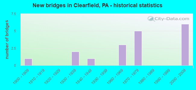
- New bridges - historical statistics
- 11900-1909
- 21930-1939
- 11940-1949
- 31960-1969
- 51970-1979
- 62000-2009
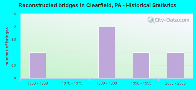
- Reconstructed bridges - Historical Statistics
- 11960-1969
- 01970-1979
- 21980-1989
- 11990-1999
- 12000-2009
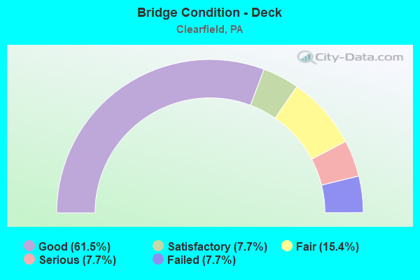
- Bridge Condition - Deck
- 61.5%Good
- 7.7%Satisfactory
- 15.4%Fair
- 7.7%Serious
- 7.7%Failed
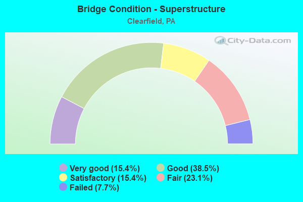
- Bridge Condition - Superstructure
- 15.4%Very good
- 38.5%Good
- 15.4%Satisfactory
- 23.1%Fair
- 7.7%Failed
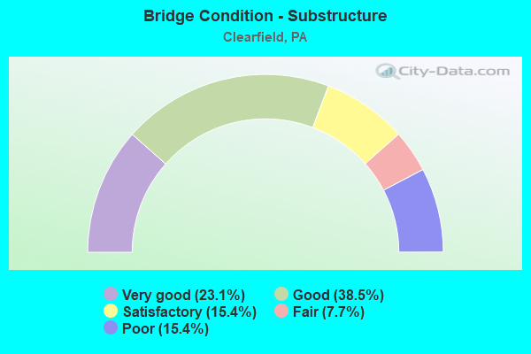
- Bridge Condition - Substructure
- 23.1%Very good
- 38.5%Good
- 15.4%Satisfactory
- 7.7%Fair
- 15.4%Poor
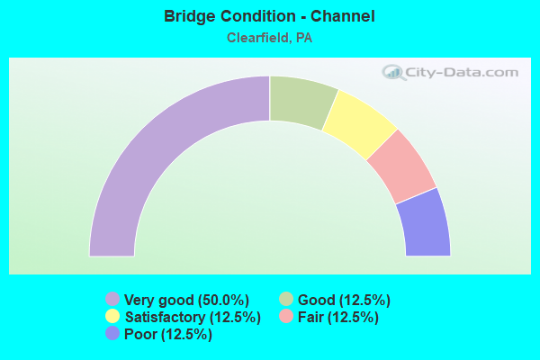
- Bridge Condition - Channel
- 50.0%Very good
- 12.5%Good
- 12.5%Satisfactory
- 12.5%Fair
- 12.5%Poor
Find on map >> Show street view
Structure Number: 11302, Location: .5 MI E EXIT 120 (Lat: 41.038006, Lng: -78.388903), Route carried "on" structure: Interstate 80, Year Built: 1967, Year Reconstructed: 2005, Status: Open, Structure Length: 32.46m (106.50ft), Average Daily Traffic: 11,344 (year 2020), Truck Traffic: 44%, Average Future Daily Traffic: 16,827 (year 2041), Design Load: HL 93, Features Intersected: W BR SUSQUEHANNA RIVER
Minimum Vertical Clearance: 30+ m (98+ ft), Kilometerpoint: 38.222, Lanes on structure: 2, Base Highway Network: Yes, Owner: State Highway Agency, Approaching Roadway Width: 11.6m (38.1ft), Skew: 10 degrees, Material/Design: Prestressed concrete continuous, Design/Construction: Stringer/Multi-beam, Number Of Spans In Main Unit: 7, Length of Maximum Span: 48.8m (160.1ft), Curb or Sidewalk Widths: Left: 0.1m (0.3ft), Right: 0.1m (0.3ft), Curb-To-Curb Width: 12.8m (42.0ft), Out-to-Out Width: 13.8m (45.3ft)
Condition: Deck: Good, Superstructure: Good, Substructure: Very good, Channel: Very good, Operating Rating: 71.7 metric tons, Method Used To Determine Operating Rating: Load and Resistance Factor (LRFR), Inventory Rating: 40.8 metric tons, Method Used To Determine Inventory Rating: Load and Resistance Factor (LRFR), Structural Evaluation: Better than present minimum criteria, Deck Geometry: Equal to present desirable criteria, Waterway Adequacy: Superior to present desirable criteria, Approach Roadway Alignment: Equal to present desirable criteria, Length Of Structure Improvement: 32.90m (107.94ft), Designated Inspection Frequency: Every 24 months, Inspection Date: June 2021, Deck Structure Type: Concrete Cast-file-Place, Wearing Surface/Protective System: Wearing Surface: Monolithic Concrete, Deck Protection: Epoxy Coated Reinforcing
Find on map >> Show street view
Structure Number: 11304, Location: .5 MI E EXIT 120 (Lat: 41.038206, Lng: -78.388772), Route carried "on" structure: Interstate 80, Year Built: 1967, Year Reconstructed: 2004, Status: Open, Structure Length: 32.43m (106.40ft), Average Daily Traffic: 11,077 (year 2020), Truck Traffic: 44%, Average Future Daily Traffic: 17,258 (year 2041), Design Load: HL 93, Features Intersected: W BR SUSQUEHANNA RIVER
Minimum Vertical Clearance: 30+ m (98+ ft), Kilometerpoint: 38.351, Lanes on structure: 2, Base Highway Network: Yes, Owner: State Highway Agency, Approaching Roadway Width: 11.6m (38.1ft), Skew: 10 degrees, Material/Design: Prestressed concrete continuous, Design/Construction: Stringer/Multi-beam, Number Of Spans In Main Unit: 7, Length of Maximum Span: 47.5m (155.8ft), Curb or Sidewalk Widths: Left: 0.1m (0.3ft), Right: 0.1m (0.3ft), Curb-To-Curb Width: 12.8m (42.0ft), Out-to-Out Width: 13.8m (45.3ft)
Condition: Deck: Good, Superstructure: Good, Substructure: Good, Channel: Very good, Operating Rating: 71.7 metric tons, Method Used To Determine Operating Rating: Load and Resistance Factor (LRFR), Inventory Rating: 40.8 metric tons, Method Used To Determine Inventory Rating: Load and Resistance Factor (LRFR), Structural Evaluation: Better than present minimum criteria, Deck Geometry: Equal to present desirable criteria, Waterway Adequacy: Superior to present desirable criteria, Approach Roadway Alignment: Equal to present desirable criteria, Length Of Structure Improvement: 32.40m (106.30ft), Designated Inspection Frequency: Every 24 months, Inspection Date: June 2021, Bridge Improvement Cost: $562,000, Roadway Improvement Cost: $1,656,000, Total Project Cost: $7,589,000, Deck Structure Type: Concrete Cast-file-Place, Wearing Surface/Protective System: Wearing Surface: Monolithic Concrete, Deck Protection: Epoxy Coated Reinforcing
Find on map >> Show street view
Structure Number: 11476, Location: CLEARFIELD BORO (Lat: 41.026806, Lng: -78.438736), Route carried "on" structure: US 322, Year Built: 1947, Year Reconstructed: 1980, Status: Open, Structure Length: 9.91m (32.51ft), Average Daily Traffic: 7,227 (year 2022), Truck Traffic: 5%, Average Future Daily Traffic: 14,579 (year 2041), Design Load: HS 20, Features Intersected: W BR SUSQUEHANNA RIVER
Minimum Vertical Clearance: 30+ m (98+ ft), Kilometerpoint: 31.199, Lanes on structure: 3, Base Highway Network: Yes, Owner: State Highway Agency, Approaching Roadway Width: 11.0m (36.1ft), Material/Design: Steel continuous, Design/Construction: Stringer/Multi-beam, Number Of Spans In Main Unit: 4, Length of Maximum Span: 27.4m (89.9ft), Curb or Sidewalk Widths: Left: 2.6m (8.5ft), Right: 2.6m (8.5ft), Curb-To-Curb Width: 11.0m (36.1ft), Out-to-Out Width: 16.2m (53.1ft)
Condition: Deck: Satisfactory, Superstructure: Fair, Substructure: Fair, Channel: Satisfactory, Operating Rating: 62.6 metric tons, Method Used To Determine Operating Rating: Load Factor (LF), Inventory Rating: 37.2 metric tons, Method Used To Determine Inventory Rating: Load Factor (LF), Structural Evaluation: Somewhat better than minimum adequacy, Deck Geometry: High priority of replacement, Waterway Adequacy: Equal to present desirable criteria, Approach Roadway Alignment: Equal to present desirable criteria, Length Of Structure Improvement: 9.90m (32.48ft), Designated Inspection Frequency: Every 24 months, Underwater Inspection Frequency: Every 60 months, Inspection Date: May 2021, Underwater Inspection Date: September 2019, Bridge Improvement Cost: $436,000, Roadway Improvement Cost: $1,284,000, Total Project Cost: $5,886,000, Deck Structure Type: Concrete Cast-file-Place, Wearing Surface/Protective System: Wearing Surface: Monolithic Concrete
Find on map >> Show street view
Structure Number: 11479, Location: CLEARFIELD (Lat: 41.017825, Lng: -78.407489), Route carried "on" structure: US 322, Year Built: 1937, Year Reconstructed: 1972, Status: Open, Structure Length: 13.01m (42.68ft), Average Daily Traffic: 8,106 (year 2022), Truck Traffic: 4%, Average Future Daily Traffic: 10,227 (year 2041), Design Load: H 20, Features Intersected: CLEARFIELD CREEK
Minimum Vertical Clearance: 30+ m (98+ ft), Kilometerpoint: 34.099, Lanes on structure: 2, Base Highway Network: Yes, Owner: State Highway Agency, Approaching Roadway Width: 11.0m (36.1ft), Skew: 3 degrees, Material/Design: Steel, Design/Construction: Girder and Floorbeam System, Number Of Spans In Main Unit: 4, Length of Maximum Span: 32.0m (105.0ft), Curb or Sidewalk Widths: Left: 0.2m (0.7ft), Right: 1.8m (5.9ft), Curb-To-Curb Width: 11.0m (36.1ft), Out-to-Out Width: 14.0m (45.9ft)
Condition: Deck: Fair, Superstructure: Satisfactory, Substructure: Satisfactory, Channel: Poor, Operating Rating: 47.2 metric tons, Method Used To Determine Operating Rating: Load Factor (LF), Inventory Rating: 28.1 metric tons, Method Used To Determine Inventory Rating: Load Factor (LF), Structural Evaluation: Equal to present minimum criteria, Deck Geometry: Meets minimum limits, Waterway Adequacy: Superior to present desirable criteria, Approach Roadway Alignment: Equal to present desirable criteria, Length Of Structure Improvement: 13.00m (42.65ft), Designated Inspection Frequency: Every 24 months, Critical Feature Inspection Frequency: Every 24 months, Underwater Inspection Frequency: Every 60 months, Other Special Inspection Frequency: Every 12 months, Inspection Date: March 2021, Critical Feature Inspection Date: April 2021, Underwater Inspection Date: October 2018, Other Special Inspection Date: April 2021, Bridge Improvement Cost: $250,000, Roadway Improvement Cost: $735,000, Total Project Cost: $3,369,000, Deck Structure Type: Concrete Cast-file-Place, Wearing Surface/Protective System: Wearing Surface: Bituminous
Find on map >> Show street view
Structure Number: 11563, Location: CLEARFIELD BORO (Lat: 41.009500, Lng: -78.433528), Route carried "on" structure: State highway 879, Year Built: 1975, Status: Open, Structure Length: 3.93m (12.89ft), Average Daily Traffic: 14,502 (year 2022), Truck Traffic: 5%, Average Future Daily Traffic: 11,146 (year 2041), Design Load: HS 20, Features Intersected: SR 153-PA 153
Minimum Vertical Clearance: 30+ m (98+ ft), Kilometerpoint: 18.049, Lanes on structure: 4, Lanes under structure: 2, Base Highway Network: Yes, Owner: State Highway Agency, Approaching Roadway Width: 28.7m (94.2ft), Material/Design: Prestressed concrete, Design/Construction: Box Beam or Girders - Single/Spread, Number Of Spans In Main Unit: 3, Length of Maximum Span: 19.8m (65.0ft), Curb or Sidewalk Widths: Left: 0.2m (0.7ft), Right: 0.2m (0.7ft), Curb-To-Curb Width: 26.5m (86.9ft), Out-to-Out Width: 27.7m (90.9ft)
Condition: Deck: Fair, Superstructure: Satisfactory, Substructure: Satisfactory, Operating Rating: 49.9 metric tons, Method Used To Determine Operating Rating: Load Factor (LF), Inventory Rating: 28.1 metric tons, Method Used To Determine Inventory Rating: Load Factor (LF), Structural Evaluation: Equal to present minimum criteria, Deck Geometry: Superior to present desirable criteria, Underclear: Equal to present minimum criteria, Approach Roadway Alignment: Equal to present desirable criteria, Length Of Structure Improvement: 3.90m (12.80ft), Designated Inspection Frequency: Every 24 months, Inspection Date: May 2021, Bridge Improvement Cost: $43,000, Roadway Improvement Cost: $250,000, Total Project Cost: $582,000, Deck Structure Type: Concrete Cast-file-Place, Wearing Surface/Protective System: Wearing Surface: Latex Concrete, Deck Protection: Galvanized Reinforcing
Find on map >> Show street view
Structure Number: 11644, Location: CLEARFIELD BORO (Lat: 41.022081, Lng: -78.441728), Route carried "on" structure: State highway , Year Built: 1938, Year Reconstructed: 1994, Status: Open, Structure Length: 9.81m (32.19ft), Average Daily Traffic: 3,410 (year 2021), Truck Traffic: 2%, Average Future Daily Traffic: 5,644 (year 2041), Design Load: H 20, Features Intersected: W BR SUSQUEHANNA RIVER, Facility Carried by Structure: SR 1004
Minimum Vertical Clearance: 4.71m (15.45ft), Kilometerpoint: 0.027, Lanes on structure: 3, Owner: State Highway Agency, Approaching Roadway Width: 11.6m (38.1ft), Skew: 1 degrees, Material/Design: Steel, Design/Construction: Truss - Thru, Number Of Spans In Main Unit: 2, Length of Maximum Span: 48.8m (160.1ft), Curb or Sidewalk Widths: Left: 1.5m (4.9ft), Right: 1.5m (4.9ft), Curb-To-Curb Width: 10.5m (34.4ft), Out-to-Out Width: 11.1m (36.4ft)
Condition: Deck: Good, Superstructure: Fair, Substructure: Good, Channel: Good, Operating Rating: 55.3 metric tons, Method Used To Determine Operating Rating: Load Factor (LF), Inventory Rating: 32.7 metric tons, Method Used To Determine Inventory Rating: Load Factor (LF), Structural Evaluation: Somewhat better than minimum adequacy, Deck Geometry: High priority of replacement, Waterway Adequacy: Equal to present desirable criteria, Approach Roadway Alignment: Equal to present desirable criteria, Length Of Structure Improvement: 10.90m (35.76ft), Designated Inspection Frequency: Every 24 months, Critical Feature Inspection Frequency: Every 24 months, Underwater Inspection Frequency: Every 60 months, Other Special Inspection Frequency: Every 24 months, Inspection Date: March 2021, Critical Feature Inspection Date: April 2021, Underwater Inspection Date: September 2019, Other Special Inspection Date: April 2021, Deck Structure Type: Concrete Cast-file-Place, Wearing Surface/Protective System: Wearing Surface: Monolithic Concrete, Deck Protection: Epoxy Coated Reinforcing
Find on map >> Show street view
Structure Number: 11729, Location: DIMELING (Lat: 40.971517, Lng: -78.406597), Route carried "on" structure: State highway , Year Built: 1966, Status: Open, Structure Length: 7.44m (24.41ft), Average Daily Traffic: 657 (year 2021), Truck Traffic: 1%, Average Future Daily Traffic: 494 (year 2040), Design Load: HS 20, Features Intersected: CLEARFIELD CREEK, Facility Carried by Structure: SR 2024
Minimum Vertical Clearance: 30+ m (98+ ft), Kilometerpoint: 8.356, Lanes on structure: 2, Owner: State Highway Agency, Approaching Roadway Width: 6.1m (20.0ft), Skew: 3 degrees, Material/Design: Prestressed concrete, Design/Construction: Box Beam or Girders - Single/Spread, Number Of Spans In Main Unit: 4, Length of Maximum Span: 18.3m (60.0ft), Curb or Sidewalk Widths: Left: 0.2m (0.7ft), Right: 0.2m (0.7ft), Curb-To-Curb Width: 9.8m (32.2ft), Out-to-Out Width: 11.0m (36.1ft)
Condition: Deck: Serious, Superstructure: Fair, Substructure: Poor, Channel: Fair, Inventory Rating: 52.6 metric tons, Method Used To Determine Inventory Rating: Load Factor (LF), Structural Evaluation: Meets minimum limits, Deck Geometry: Equal to present minimum criteria, Waterway Adequacy: Superior to present desirable criteria, Approach Roadway Alignment: Better than present minimum criteria, Length Of Structure Improvement: 7.40m (24.28ft), Designated Inspection Frequency: Every 24 months, Inspection Date: August 2020, Bridge Improvement Cost: $78,000, Roadway Improvement Cost: $250,000, Total Project Cost: $1,052,000, Deck Structure Type: Concrete Cast-file-Place, Wearing Surface/Protective System: Wearing Surface: Monolithic Concrete
Find on map >> Show street view
Structure Number: 11939, Location: LEONARDSTEXTBEHINDPADOTOF (Lat: 41.023497, Lng: -78.407300), Route carried "on" structure: ServiceCity street , Year Built: 1902, Status: Closed, Structure Length: 2.74m (8.99ft), Design Load: HS 20, Features Intersected: RJ CORMAN RR, Facility Carried by Structure: LEONARD ST EXT
Minimum Vertical Clearance: 30+ m (98+ ft), Kilometerpoint: 0.000, Lanes on structure: 1, Owner: County Highway Agency, Approaching Roadway Width: 4.3m (14.1ft), Material/Design: Aluminum, Iron, Design/Construction: Truss - Thru, Number Of Spans In Main Unit: 1, Length of Maximum Span: 26.5m (86.9ft), Curb or Sidewalk Widths: Left: 0.2m (0.7ft), Right: 0.2m (0.7ft), Curb-To-Curb Width: 3.9m (12.8ft), Out-to-Out Width: 4.2m (13.8ft)
Condition: Deck: Failed, Superstructure: Failed, Substructure: Poor, Deck Geometry: Meets minimum limits, Approach Roadway Alignment: High priority of corrective action, Bridge Posting: Required (Relationship of Operating Rating to Maximum Legal Load: > 39.9% below), Length Of Structure Improvement: 3.40m (11.15ft), Designated Inspection Frequency: Every 24 months, Critical Feature Inspection Frequency: Every 24 months, Inspection Date: September 2021, Critical Feature Inspection Date: September 2021, Bridge Improvement Cost: $85,000, Roadway Improvement Cost: $264,000, Total Project Cost: $1,151,000, Deck Structure Type: Wood or Timber
Find on map >> Show street view
Structure Number: 42457, Location: EXIT 120 CLEARFIELD INTER (Lat: 41.039497, Lng: -78.398128), Route carried "on" structure: Interstate 80, Year Built: 2004, Status: Open, Structure Length: 2.99m (9.81ft), Average Daily Traffic: 11,077 (year 2020), Truck Traffic: 44%, Average Future Daily Traffic: 17,258 (year 2041), Design Load: HL 93, Features Intersected: SR 879-PA 879
Minimum Vertical Clearance: 30+ m (98+ ft), Kilometerpoint: 37.527, Lanes on structure: 2, Lanes under structure: 3, Base Highway Network: Yes, Owner: State Highway Agency, Approaching Roadway Width: 11.6m (38.1ft), Skew: 10 degrees, Material/Design: Prestressed concrete, Design/Construction: Box Beam or Girders - Single/Spread, Number Of Spans In Main Unit: 1, Length of Maximum Span: 29.6m (97.1ft), Curb or Sidewalk Widths: Left: 0.1m (0.3ft), Right: 0.1m (0.3ft), Curb-To-Curb Width: 12.8m (42.0ft), Out-to-Out Width: 13.7m (44.9ft)
Condition: Deck: Good, Superstructure: Good, Substructure: Good, Operating Rating: 98.9 metric tons, Method Used To Determine Operating Rating: Load Factor (LF), Inventory Rating: 39.9 metric tons, Method Used To Determine Inventory Rating: Load Factor (LF), Structural Evaluation: Better than present minimum criteria, Deck Geometry: Equal to present desirable criteria, Underclear: Superior to present desirable criteria, Approach Roadway Alignment: Equal to present desirable criteria, Length Of Structure Improvement: 3.70m (12.14ft), Designated Inspection Frequency: Every 24 months, Inspection Date: June 2021, Deck Structure Type: Concrete Cast-file-Place, Wearing Surface/Protective System: Wearing Surface: Monolithic Concrete, Deck Protection: Epoxy Coated Reinforcing
Find on map >> Show street view
Structure Number: 42464, Location: .8 MI EAST OF EXIT 120 (Lat: 41.037342, Lng: -78.385283), Route carried "on" structure: Interstate 80, Year Built: 2004, Status: Open, Structure Length: 4.60m (15.09ft), Average Daily Traffic: 11,077 (year 2020), Truck Traffic: 44%, Average Future Daily Traffic: 17,258 (year 2041), Design Load: HL 93, Features Intersected: R J CORMAN
Minimum Vertical Clearance: 30+ m (98+ ft), Kilometerpoint: 38.351, Lanes on structure: 2, Base Highway Network: Yes, Owner: State Highway Agency, Approaching Roadway Width: 11.6m (38.1ft), Skew: 12 degrees, Material/Design: Prestressed concrete, Design/Construction: Stringer/Multi-beam, Number Of Spans In Main Unit: 1, Length of Maximum Span: 43.9m (144.0ft), Curb or Sidewalk Widths: Left: 0.1m (0.3ft), Right: 0.1m (0.3ft), Curb-To-Curb Width: 12.8m (42.0ft), Out-to-Out Width: 13.8m (45.3ft)
Condition: Deck: Good, Superstructure: Very good, Substructure: Good, Operating Rating: 92.5 metric tons, Method Used To Determine Operating Rating: Load Factor (LF), Inventory Rating: 43.5 metric tons, Method Used To Determine Inventory Rating: Load Factor (LF), Structural Evaluation: Better than present minimum criteria, Deck Geometry: Equal to present desirable criteria, Underclear: High priority of corrective action, Approach Roadway Alignment: Equal to present desirable criteria, Length Of Structure Improvement: 5.50m (18.04ft), Designated Inspection Frequency: Every 24 months, Inspection Date: June 2021, Deck Structure Type: Concrete Cast-file-Place, Wearing Surface/Protective System: Wearing Surface: Monolithic Concrete, Deck Protection: Epoxy Coated Reinforcing
Find on map >> Show street view
Structure Number: 43017, Location: .8 MI EAST OF EXIT 120 (Lat: 41.037186, Lng: -78.385603), Route carried "on" structure: Interstate 80, Year Built: 2005, Status: Open, Structure Length: 4.60m (15.09ft), Average Daily Traffic: 11,344 (year 2020), Truck Traffic: 44%, Average Future Daily Traffic: 16,827 (year 2041), Design Load: HL 93, Features Intersected: R J CORMAN
Minimum Vertical Clearance: 30+ m (98+ ft), Kilometerpoint: 38.222, Lanes on structure: 2, Base Highway Network: Yes, Owner: State Highway Agency, Approaching Roadway Width: 11.6m (38.1ft), Skew: 12 degrees, Material/Design: Prestressed concrete, Design/Construction: Stringer/Multi-beam, Number Of Spans In Main Unit: 1, Length of Maximum Span: 43.9m (144.0ft), Curb or Sidewalk Widths: Left: 0.1m (0.3ft), Right: 0.1m (0.3ft), Curb-To-Curb Width: 12.8m (42.0ft), Out-to-Out Width: 13.8m (45.3ft)
Condition: Deck: Good, Superstructure: Very good, Substructure: Very good, Operating Rating: 78.0 metric tons, Method Used To Determine Operating Rating: Load Factor (LF), Inventory Rating: 37.2 metric tons, Method Used To Determine Inventory Rating: Load Factor (LF), Structural Evaluation: Equal to present desirable criteria, Deck Geometry: Equal to present desirable criteria, Underclear: High priority of corrective action, Approach Roadway Alignment: Equal to present desirable criteria, Length Of Structure Improvement: 5.50m (18.04ft), Designated Inspection Frequency: Every 24 months, Inspection Date: June 2021, Deck Structure Type: Concrete Cast-file-Place, Wearing Surface/Protective System: Wearing Surface: Monolithic Concrete, Deck Protection: Epoxy Coated Reinforcing
Find on map >> Show street view
Structure Number: 44221, Location: 3 MI SE OF CLEARFIELD (Lat: 40.986200, Lng: -78.406075), Route carried "on" structure: State highway 153, Year Built: 2007, Status: Open, Structure Length: 10.49m (34.42ft), Average Daily Traffic: 2,877 (year 2021), Truck Traffic: 8%, Average Future Daily Traffic: 3,744 (year 2040), Design Load: HL 93, Features Intersected: CLEARFIELD CREEK
Minimum Vertical Clearance: 30+ m (98+ ft), Kilometerpoint: 31.628, Lanes on structure: 2, Base Highway Network: Yes, Owner: State Highway Agency, Approaching Roadway Width: 12.2m (40.0ft), Material/Design: Prestressed concrete continuous, Design/Construction: Stringer/Multi-beam, Number Of Spans In Main Unit: 3, Length of Maximum Span: 35.1m (115.2ft), Curb or Sidewalk Widths: Left: 0.1m (0.3ft), Right: 0.1m (0.3ft), Curb-To-Curb Width: 12.2m (40.0ft), Out-to-Out Width: 13.2m (43.3ft)
Condition: Deck: Good, Superstructure: Good, Substructure: Very good, Channel: Very good, Operating Rating: 70.8 metric tons, Method Used To Determine Operating Rating: Load Factor (LF), Inventory Rating: 36.3 metric tons, Method Used To Determine Inventory Rating: Load Factor (LF), Structural Evaluation: Better than present minimum criteria, Deck Geometry: Equal to present minimum criteria, Waterway Adequacy: Superior to present desirable criteria, Approach Roadway Alignment: Better than present minimum criteria, Designated Inspection Frequency: Every 24 months, Inspection Date: August 2020, Deck Structure Type: Concrete Cast-file-Place, Wearing Surface/Protective System: Wearing Surface: Monolithic Concrete, Deck Protection: Epoxy Coated Reinforcing
Find on map >> Show street view
Structure Number: 44945, Location: 2.5 MI NE CLEARFIELD (Lat: 41.048400, Lng: -78.382994), Route carried "on" structure: State highway 879, Year Built: 2009, Status: Open, Structure Length: 19.51m (64.01ft), Average Daily Traffic: 5,152 (year 2022), Truck Traffic: 15%, Average Future Daily Traffic: 2,840 (year 2041), Design Load: HL 93, Features Intersected: LICK RUN
Minimum Vertical Clearance: 30+ m (98+ ft), Kilometerpoint: 25.148, Lanes on structure: 2, Owner: State Highway Agency, Approaching Roadway Width: 9.8m (32.2ft), Skew: 9 degrees, Material/Design: Prestressed concrete continuous, Design/Construction: Stringer/Multi-beam, Number Of Spans In Main Unit: 5, Length of Maximum Span: 39.0m (128.0ft), Curb or Sidewalk Widths: Left: 0.2m (0.7ft), Right: 0.2m (0.7ft), Curb-To-Curb Width: 14.3m (46.9ft), Out-to-Out Width: 15.4m (50.5ft)
Condition: Deck: Good, Superstructure: Good, Substructure: Good, Channel: Very good, Operating Rating: 85.3 metric tons, Method Used To Determine Operating Rating: Load Factor (LF), Inventory Rating: 38.1 metric tons, Method Used To Determine Inventory Rating: Load Factor (LF), Structural Evaluation: Better than present minimum criteria, Deck Geometry: Superior to present desirable criteria, Waterway Adequacy: Superior to present desirable criteria, Approach Roadway Alignment: Equal to present desirable criteria, Designated Inspection Frequency: Every 24 months, Inspection Date: May 2021, Deck Structure Type: Concrete Cast-file-Place, Wearing Surface/Protective System: Wearing Surface: Epoxy Overlay, Deck Protection: Epoxy Coated Reinforcing
Find on map >> Show street view
Structure Number: 11563, Location: CLEARFIELD BORO (Lat: 41.009500, Lng: -78.433528), Route carried "under" structure: Spur State highway 153, Year Built: 1975, Structure Length: 0. m, Average Daily Traffic: 3,611 (year 2022), Truck Traffic: 5%, Features Intersected: SR 153-PA 153, Facility Carried by Structure: SR 879-PA 879
Minimum Vertical Clearance: 4.41m (14.47ft), Kilometerpoint: 35.349, Lanes on structure: 4, Lanes under structure: 2, Material/Design: Prestressed concrete, Design/Construction: Box Beam or Girders - Single/Spread, Length of Maximum Span: 19.8m (65.0ft)
Find on map >> Show street view
Structure Number: 11564, Location: CLEARFIELD (Lat: 41.017486, Lng: -78.428047), Route carried "under" structure: City street , Year Built: 1975, Structure Length: 0. m, Average Daily Traffic: 907 (year 1999), Truck Traffic: 5%, Features Intersected: TOWNSHIP ROAD 991, Facility Carried by Structure: SR 879-PA 879
Minimum Vertical Clearance: 8.28m (27.17ft), Kilometerpoint: 0.000, Lanes on structure: 3, Lanes under structure: 2, Material/Design: Prestressed concrete, Design/Construction: Stringer/Multi-beam, Length of Maximum Span: 23.5m (77.1ft)
Find on map >> Show street view
Structure Number: 11566, Location: CLEARFIELD (Lat: 41.023333, Lng: -78.380000), Route carried "under" structure: US 322, Year Built: 1974, Structure Length: 0. m, Average Daily Traffic: 3,614 (year 2022), Truck Traffic: 5%, Features Intersected: SR 322-US 322, Facility Carried by Structure: SR 879-PA 879
Minimum Vertical Clearance: 5.25m (17.22ft), Kilometerpoint: 33.235, Lanes on structure: 4, Lanes under structure: 4, Material/Design: Steel, Design/Construction: Stringer/Multi-beam, Length of Maximum Span: 38.7m (127.0ft)
Find on map >> Show street view
Structure Number: 11566, Location: CLEARFIELD (Lat: 41.023333, Lng: -78.380000), Route carried "under" structure: US 322, Year Built: 1974, Structure Length: 0. m, Average Daily Traffic: 3,614 (year 2022), Truck Traffic: 5%, Features Intersected: SR 322-US 322, Facility Carried by Structure: SR 879-PA 879
Minimum Vertical Clearance: 5.16m (16.93ft), Kilometerpoint: 33.235, Lanes on structure: 4, Lanes under structure: 4, Material/Design: Steel, Design/Construction: Stringer/Multi-beam, Length of Maximum Span: 38.7m (127.0ft)
Find on map >> Show street view
Structure Number: 42457, Location: EXIT 120 CLEARFIELD INTER (Lat: 41.039497, Lng: -78.398128), Route carried "under" structure: State highway 879, Year Built: 2004, Structure Length: 0. m, Average Daily Traffic: 5,152 (year 2022), Truck Traffic: 15%, Features Intersected: SR 879-PA 879, Facility Carried by Structure: SR 80-I 80
Minimum Vertical Clearance: 5.06m (16.60ft), Kilometerpoint: 22.690, Lanes on structure: 2, Lanes under structure: 3, Material/Design: Prestressed concrete, Design/Construction: Box Beam or Girders - Single/Spread, Length of Maximum Span: 29.6m (97.1ft)