Bridge Statistics for Climax, Minnesota (MN)
Condition, Traffic, Stress, Structural Evaluation, Project Costs
- National Bridge Inventory (NBI) Statistics
- 11Number of bridges
- 187ft / 57.0mTotal length
- $1,160,002,000Total costs
- 2,724Total average daily traffic
- 313Total average daily truck traffic
- 2,794Total future (year 2029) average daily traffic
- National Bridge Inventory (NBI) Registered Bridges for Climax
- No street view available for this location
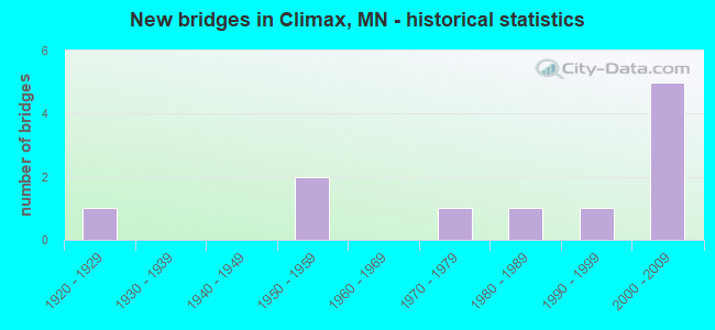
- New bridges - historical statistics
- 11920-1929
- 21950-1959
- 11970-1979
- 11980-1989
- 11990-1999
- 52000-2009
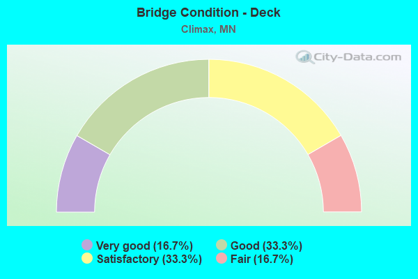
- Bridge Condition - Deck
- 16.7%Very good
- 33.3%Good
- 33.3%Satisfactory
- 16.7%Fair
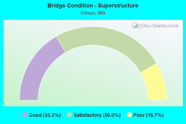
- Bridge Condition - Superstructure
- 33.3%Good
- 50.0%Satisfactory
- 16.7%Poor
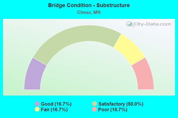
- Bridge Condition - Substructure
- 16.7%Good
- 50.0%Satisfactory
- 16.7%Fair
- 16.7%Poor
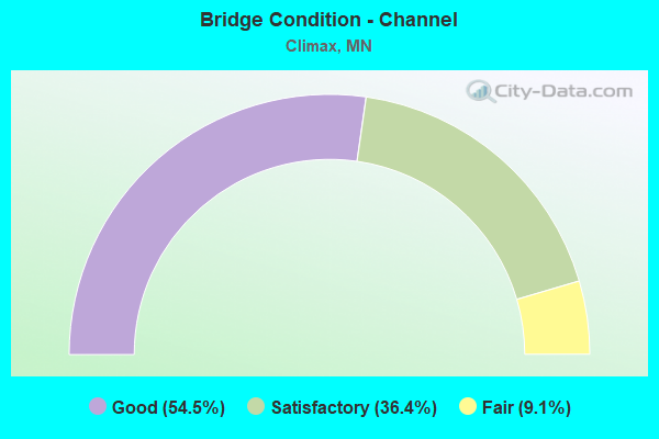
- Bridge Condition - Channel
- 54.5%Good
- 36.4%Satisfactory
- 9.1%Fair
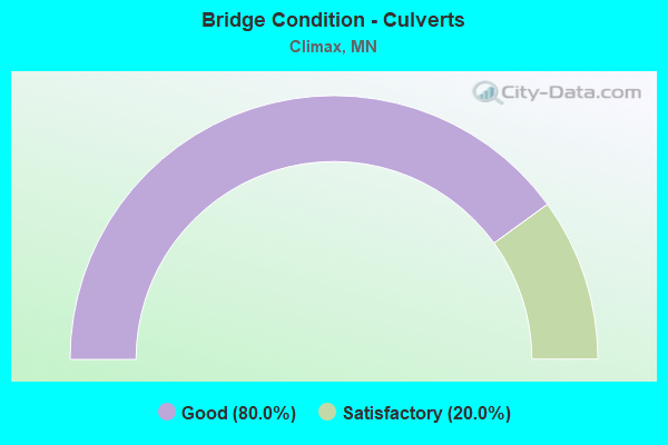
- Bridge Condition - Culverts
- 80.0%Good
- 20.0%Satisfactory
Find on map >> Show street view
Structure Number: 60021, Location: 0.3 MI N OF JCT TH 220 (Lat: 47.612069, Lng: -96.814864), Route carried "on" structure: US 75, Year Built: 1995, Status: Open, Structure Length: 7.13m (23.39ft), Average Daily Traffic: 1,100 (year 2019), Truck Traffic: 15%, Average Future Daily Traffic: 1,250 (year 2039), Design Load: HS 25 or greater, Features Intersected: SAND HILL RIVER
Minimum Vertical Clearance: 30+ m (98+ ft), Kilometerpoint: 0.000, Lanes on structure: 2, Base Highway Network: Yes, Owner: State Highway Agency, Approaching Roadway Width: 14.6m (47.9ft), Material/Design: Steel continuous, Design/Construction: Stringer/Multi-beam, Number Of Spans In Main Unit: 3, Length of Maximum Span: 30.5m (100.1ft), Curb-To-Curb Width: 13.4m (44.0ft), Out-to-Out Width: 14.4m (47.2ft)
Condition: Deck: Very good, Superstructure: Satisfactory, Substructure: Poor, Channel: Satisfactory, Operating Rating: 81.0 metric tons, Method Used To Determine Operating Rating: Load Factor (LF), Inventory Rating: 48.5 metric tons, Method Used To Determine Inventory Rating: Load Factor (LF), Structural Evaluation: Meets minimum limits, Deck Geometry: Equal to present desirable criteria, Waterway Adequacy: High priority of corrective action, Approach Roadway Alignment: Better than present minimum criteria, Designated Inspection Frequency: Every 24 months, Inspection Date: May 2021, Deck Structure Type: Concrete Cast-file-Place, Wearing Surface/Protective System: Wearing Surface: Monolithic Concrete, Deck Protection: Epoxy Coated Reinforcing
Find on map >> Show street view
Structure Number: 60524, Location: 1.7 MI E OF JCT TH 75 (Lat: 47.571608, Lng: -96.779717), Route carried "on" structure: County highway 51, Year Built: 1977, Status: Open, Structure Length: 4.79m (15.72ft), Average Daily Traffic: 40 (year 2017), Average Future Daily Traffic: 40 (year 2039), Design Load: HS 20, Features Intersected: SAND HILL RIVER
Minimum Vertical Clearance: 30+ m (98+ ft), Kilometerpoint: 0.000, Lanes on structure: 2, Owner: County Highway Agency, Approaching Roadway Width: 12.2m (40.0ft), Material/Design: Prestressed concrete, Design/Construction: Tee Beam, Number Of Spans In Main Unit: 3, Length of Maximum Span: 15.9m (52.2ft), Curb-To-Curb Width: 10.2m (33.5ft), Out-to-Out Width: 11.4m (37.4ft)
Condition: Deck: Satisfactory, Superstructure: Satisfactory, Substructure: Satisfactory, Channel: Good, Operating Rating: 36.6 metric tons, Method Used To Determine Operating Rating: Load Factor (LF), Inventory Rating: 21.9 metric tons, Method Used To Determine Inventory Rating: Load Factor (LF), Structural Evaluation: Equal to present minimum criteria, Deck Geometry: Superior to present desirable criteria, Waterway Adequacy: Equal to present desirable criteria, Approach Roadway Alignment: Equal to present desirable criteria, Designated Inspection Frequency: Every 24 months, Inspection Date: October 2020, Deck Structure Type: Concrete Cast-file-Place, Wearing Surface/Protective System: Wearing Surface: Bituminous
Find on map >> Show street view
Structure Number: 60532, Location: 1.0 mi E of jct TH 75 (Lat: 47.600636, Lng: -96.793556), Route carried "on" structure: County highway 940, Year Built: 2001, Status: Open, Structure Length: 6.48m (21.26ft), Average Daily Traffic: 34 (year 2001), Average Future Daily Traffic: 34 (year 2029), Design Load: HS 25 or greater, Features Intersected: Sand Hill River
Minimum Vertical Clearance: 30+ m (98+ ft), Kilometerpoint: 0.000, Lanes on structure: 2, Owner: Town or Township Highway Agency, Approaching Roadway Width: 7.3m (24.0ft), Skew: 2 degrees, Material/Design: Prestressed concrete, Design/Construction: Stringer/Multi-beam, Number Of Spans In Main Unit: 4, Length of Maximum Span: 19.2m (63.0ft), Curb-To-Curb Width: 8.5m (27.9ft), Out-to-Out Width: 9.5m (31.2ft)
Condition: Deck: Good, Superstructure: Good, Substructure: Good, Channel: Good, Operating Rating: 71.7 metric tons, Method Used To Determine Operating Rating: Load Factor (LF), Inventory Rating: 42.9 metric tons, Method Used To Determine Inventory Rating: Load Factor (LF), Structural Evaluation: Better than present minimum criteria, Deck Geometry: Better than present minimum criteria, Waterway Adequacy: Equal to present desirable criteria, Approach Roadway Alignment: Equal to present minimum criteria, Designated Inspection Frequency: Every 24 months, Inspection Date: October 2021, Deck Structure Type: Concrete Cast-file-Place, Wearing Surface/Protective System: Wearing Surface: Monolithic Concrete, Deck Protection: Epoxy Coated Reinforcing
Find on map >> Show street view
Structure Number: 6054, Location: 1.2 MI E OF JCT TH 75 (Lat: 47.585922, Lng: -96.790153), Route carried "on" structure: County highway 64, Year Built: 2000, Status: Open, Structure Length: 4.68m (15.35ft), Average Daily Traffic: 15 (year 2000), Average Future Daily Traffic: 15 (year 2029), Design Load: HS 25 or greater, Features Intersected: SAND HILL RIVER
Minimum Vertical Clearance: 30+ m (98+ ft), Kilometerpoint: 0.000, Lanes on structure: 2, Owner: Town or Township Highway Agency, Approaching Roadway Width: 9.6m (31.5ft), Skew: 2 degrees, Material/Design: Concrete continuous, Design/Construction: Slab, Number Of Spans In Main Unit: 3, Length of Maximum Span: 18.4m (60.4ft), Curb-To-Curb Width: 9.6m (31.5ft), Out-to-Out Width: 10.5m (34.4ft)
Condition: Deck: Good, Superstructure: Good, Substructure: Satisfactory, Channel: Good, Operating Rating: 76.6 metric tons, Method Used To Determine Operating Rating: Load Factor (LF), Inventory Rating: 45.9 metric tons, Method Used To Determine Inventory Rating: Load Factor (LF), Structural Evaluation: Equal to present minimum criteria, Deck Geometry: Better than present minimum criteria, Waterway Adequacy: Equal to present desirable criteria, Approach Roadway Alignment: Better than present minimum criteria, Designated Inspection Frequency: Every 24 months, Inspection Date: October 2021, Deck Structure Type: Concrete Cast-file-Place, Wearing Surface/Protective System: Wearing Surface: Monolithic Concrete, Deck Protection: Epoxy Coated Reinforcing
Find on map >> Show street view
Structure Number: 60K07, Location: 0.4 MI S OF JCT CSAH 41 (Lat: 47.609950, Lng: -96.793244), Route carried "on" structure: County highway 164, Year Built: 2005, Status: Open, Structure Length: 0.67m (2.20ft), Average Daily Traffic: 15 (year 2005), Average Future Daily Traffic: 15 (year 2029), Design Load: HS 25 or greater, Features Intersected: COULEE
Minimum Vertical Clearance: 30+ m (98+ ft), Kilometerpoint: 0.000, Lanes on structure: 2, Owner: Town or Township Highway Agency, Approaching Roadway Width: 7.3m (24.0ft), Material/Design: Concrete, Design/Construction: Culvert, Number Of Spans In Main Unit: 2, Length of Maximum Span: 3.0m (9.8ft)
Condition: Channel: Fair, Culverts: Good, Operating Rating: 58.8 metric tons, Method Used To Determine Operating Rating: Assigned rating based on Load Factor Design (LFD) reported in metric tons, Inventory Rating: 39.2 metric tons, Method Used To Determine Inventory Rating: Assigned rating based on Load Factor Design (LFD) reported in metric tons, Structural Evaluation: Better than present minimum criteria, Waterway Adequacy: Equal to present desirable criteria, Approach Roadway Alignment: Equal to present desirable criteria, Length Of Structure Improvement: 0.34m (1.12ft), Designated Inspection Frequency: Every 24 months, Inspection Date: October 2020, Bridge Improvement Cost: $49,000,000, Roadway Improvement Cost: $1,000, Total Project Cost: $1,000
Find on map >> Show street view
Structure Number: 60K57, Location: 0.1 MI S OF JCT CSAH 41 (Lat: 47.614853, Lng: -96.771758), Route carried "on" structure: County highway 174, Year Built: 2005, Status: Open, Structure Length: 0.91m (2.99ft), Average Daily Traffic: 20 (year 2005), Average Future Daily Traffic: 20 (year 2029), Design Load: HS 25 or greater, Features Intersected: CO DITCH # 6
Minimum Vertical Clearance: 30+ m (98+ ft), Kilometerpoint: 0.000, Lanes on structure: 2, Owner: Town or Township Highway Agency, Approaching Roadway Width: 7.3m (24.0ft), Material/Design: Concrete, Design/Construction: Culvert, Number Of Spans In Main Unit: 2, Length of Maximum Span: 4.3m (14.1ft)
Condition: Channel: Satisfactory, Culverts: Good, Operating Rating: 58.8 metric tons, Method Used To Determine Operating Rating: Assigned rating based on Load Factor Design (LFD) reported in metric tons, Inventory Rating: 39.2 metric tons, Method Used To Determine Inventory Rating: Assigned rating based on Load Factor Design (LFD) reported in metric tons, Structural Evaluation: Better than present minimum criteria, Waterway Adequacy: Equal to present desirable criteria, Approach Roadway Alignment: Equal to present desirable criteria, Length Of Structure Improvement: 0.46m (1.51ft), Designated Inspection Frequency: Every 48 months, Inspection Date: October 2020, Bridge Improvement Cost: $67,000,000, Roadway Improvement Cost: $1,000, Total Project Cost: $1,000
Find on map >> Show street view
Structure Number: 60K58, Location: 0.1 MI S OF JCT CSAH 41 (Lat: 47.615047, Lng: -96.750467), Route carried "on" structure: County highway 72, Year Built: 2005, Status: Open, Structure Length: 0.79m (2.59ft), Average Daily Traffic: 10 (year 2005), Average Future Daily Traffic: 10 (year 2029), Design Load: HS 25 or greater, Features Intersected: CO DITCH # 6
Minimum Vertical Clearance: 30+ m (98+ ft), Kilometerpoint: 0.000, Lanes on structure: 2, Owner: Town or Township Highway Agency, Approaching Roadway Width: 7.3m (24.0ft), Material/Design: Concrete, Design/Construction: Culvert, Number Of Spans In Main Unit: 2, Length of Maximum Span: 3.7m (12.1ft)
Condition: Channel: Good, Culverts: Good, Operating Rating: 58.8 metric tons, Method Used To Determine Operating Rating: Assigned rating based on Load Factor Design (LFD) reported in metric tons, Inventory Rating: 39.2 metric tons, Method Used To Determine Inventory Rating: Assigned rating based on Load Factor Design (LFD) reported in metric tons, Structural Evaluation: Better than present minimum criteria, Waterway Adequacy: Equal to present desirable criteria, Approach Roadway Alignment: Equal to present desirable criteria, Length Of Structure Improvement: 0.40m (1.31ft), Designated Inspection Frequency: Every 48 months, Inspection Date: October 2018, Bridge Improvement Cost: $58,000,000, Roadway Improvement Cost: $1,000, Total Project Cost: $1,000
Find on map >> Show street view
Structure Number: 7097, Location: 0.2 MI W OF JCT TH 220 (Lat: 47.607825, Lng: -96.854911), Route carried "on" structure: County highway 7, Year Built: 1957, Status: Posted for load, Structure Length: 23.07m (75.69ft), Average Daily Traffic: 470 (year 2013), Average Future Daily Traffic: 470 (year 2039), Design Load: H 20, Features Intersected: RED RIVER OF THE NORTH
Minimum Vertical Clearance: 4.88m (16.01ft), Kilometerpoint: 0.000, Lanes on structure: 2, Base Highway Network: Yes, Owner: County Highway Agency, Approaching Roadway Width: 11.3m (37.1ft), Material/Design: Steel, Design/Construction: Truss - Thru, Number Of Spans In Main Unit: 2, Number Of Approach Spans: 5, Length of Maximum Span: 67.1m (220.1ft), Curb-To-Curb Width: 7.3m (24.0ft), Out-to-Out Width: 7.9m (25.9ft)
Condition: Deck: Fair, Superstructure: Poor, Substructure: Fair, Channel: Satisfactory, Operating Rating: 24.3 metric tons, Method Used To Determine Operating Rating: Load Factor (LF), Inventory Rating: 14.5 metric tons, Method Used To Determine Inventory Rating: Load Factor (LF), Structural Evaluation: Meets minimum limits, Deck Geometry: Meets minimum limits, Waterway Adequacy: Somewhat better than minimum adequacy, Approach Roadway Alignment: High priority of replacement, Bridge Posting: Required (Relationship of Operating Rating to Maximum Legal Load: 30.0 - 39.9% below), Length Of Structure Improvement: 7.04m (23.10ft), Designated Inspection Frequency: Every 12 months, Critical Feature Inspection Frequency: Every 24 months, Underwater Inspection Frequency: Every 60 months, Inspection Date: October 2021, Critical Feature Inspection Date: September 2020, Underwater Inspection Date: July 2020, Bridge Improvement Cost: $999,999,000, Roadway Improvement Cost: $196,000,000, Total Project Cost: $999,999,000, Deck Structure Type: Concrete Cast-file-Place, Wearing Surface/Protective System: Wearing Surface: Monolithic Concrete
Find on map >> Show street view
Structure Number: 8946, Location: 0.5 MI W OF JCT CSAH17 (Lat: 45.224481, Lng: -95.786606), Route carried "on" structure: County highway 8, Year Built: 1920, Status: Open, Structure Length: 0.85m (2.79ft), Average Daily Traffic: 80 (year 2017), Average Future Daily Traffic: 80 (year 2039), Features Intersected: JUD DITCH # 8
Minimum Vertical Clearance: 30+ m (98+ ft), Kilometerpoint: 0.000, Lanes on structure: 2, Owner: County Highway Agency, Approaching Roadway Width: 9.8m (32.2ft), Material/Design: Concrete, Design/Construction: Culvert, Number Of Spans In Main Unit: 3, Length of Maximum Span: 2.1m (6.9ft)
Condition: Channel: Satisfactory, Culverts: Satisfactory, Operating Rating: 34.3 metric tons, Method Used To Determine Operating Rating: Field evaluation and documented engineering judgment, Inventory Rating: 22.9 metric tons, Method Used To Determine Inventory Rating: Field evaluation and documented engineering judgment, Structural Evaluation: Equal to present minimum criteria, Waterway Adequacy: Equal to present desirable criteria, Approach Roadway Alignment: Equal to present desirable criteria, Length Of Structure Improvement: 0.43m (1.41ft), Designated Inspection Frequency: Every 24 months, Inspection Date: October 2021, Bridge Improvement Cost: $63,000,000, Roadway Improvement Cost: $10,000,000, Total Project Cost: $160,000,000
Find on map >> Show street view
Structure Number: 9239, Location: 0.5 MI W OF CLIMAX (Lat: 47.607761, Lng: -96.826417), Route carried "on" structure: State highway 220, Year Built: 1957, Status: Open, Structure Length: 6.85m (22.47ft), Average Daily Traffic: 930 (year 2019), Truck Traffic: 16%, Average Future Daily Traffic: 850 (year 2039), Design Load: HS 20+Mod, Features Intersected: SAND HILL RIVER
Minimum Vertical Clearance: 30+ m (98+ ft), Kilometerpoint: 0.000, Lanes on structure: 2, Base Highway Network: Yes, Owner: State Highway Agency, Approaching Roadway Width: 11.3m (37.1ft), Material/Design: Steel continuous, Design/Construction: Stringer/Multi-beam, Number Of Spans In Main Unit: 3, Length of Maximum Span: 25.9m (85.0ft), Curb-To-Curb Width: 9.8m (32.2ft), Out-to-Out Width: 10.7m (35.1ft)
Condition: Deck: Satisfactory, Superstructure: Satisfactory, Substructure: Satisfactory, Channel: Good, Operating Rating: 55.1 metric tons, Method Used To Determine Operating Rating: Load Factor (LF), Inventory Rating: 33.0 metric tons, Method Used To Determine Inventory Rating: Load Factor (LF), Structural Evaluation: Equal to present minimum criteria, Deck Geometry: Equal to present minimum criteria, Waterway Adequacy: Meets minimum limits, Approach Roadway Alignment: Better than present minimum criteria, Designated Inspection Frequency: Every 24 months, Other Special Inspection Frequency: Every 48 months, Inspection Date: May 2021, Other Special Inspection Date: September 2020, Deck Structure Type: Concrete Cast-file-Place, Wearing Surface/Protective System: Wearing Surface: Low Slump Concrete
Find on map >> Show street view
Structure Number: 95718, Location: 2.5 MI N OF JCT CSAH 1 (Lat: 47.564311, Lng: -96.750533), Route carried "on" structure: County highway 72, Year Built: 1982, Status: Open, Structure Length: 0.78m (2.56ft), Average Daily Traffic: 10 (year 1982), Average Future Daily Traffic: 10 (year 2029), Design Load: HS 20, Features Intersected: CO DITCH # 73
Minimum Vertical Clearance: 30+ m (98+ ft), Kilometerpoint: 0.000, Lanes on structure: 2, Owner: Town or Township Highway Agency, Approaching Roadway Width: 6.1m (20.0ft), Material/Design: Concrete, Design/Construction: Culvert, Number Of Spans In Main Unit: 2, Length of Maximum Span: 3.0m (9.8ft)
Condition: Channel: Good, Culverts: Good, Operating Rating: 58.8 metric tons, Method Used To Determine Operating Rating: Assigned rating based on Load Factor Design (LFD) reported in metric tons, Inventory Rating: 39.2 metric tons, Method Used To Determine Inventory Rating: Assigned rating based on Load Factor Design (LFD) reported in metric tons, Structural Evaluation: Better than present minimum criteria, Waterway Adequacy: Equal to present desirable criteria, Approach Roadway Alignment: Equal to present desirable criteria, Designated Inspection Frequency: Every 48 months, Inspection Date: October 2021