Bridge Statistics for Coeburn, Virginia (VA)
Condition, Traffic, Stress, Structural Evaluation, Project Costs
- National Bridge Inventory (NBI) Statistics
- 24Number of bridges
- 246ft / 75.0mTotal length
- $308,000Total costs
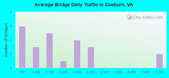
- 54,424Total average daily traffic
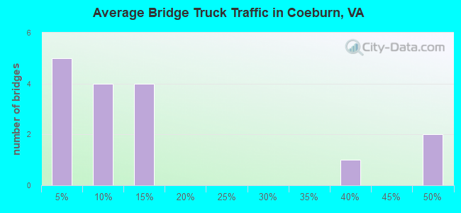
- 5,468Total average daily truck traffic
- National Bridge Inventory (NBI) Registered Bridges for Coeburn
- No street view available for this location
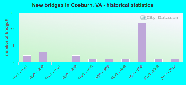
- New bridges - historical statistics
- 21920-1929
- 31930-1939
- 21950-1959
- 11960-1969
- 11970-1979
- 11980-1989
- 121990-1999
- 12000-2009
- 12010-2019
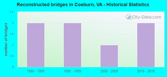
- Reconstructed bridges - Historical Statistics
- 21980-1989
- 21990-1999
- 12000-2009
- 22010-2019
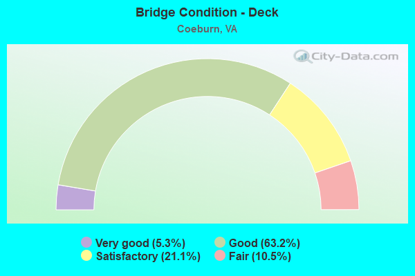
- Bridge Condition - Deck
- 5.3%Very good
- 63.2%Good
- 21.1%Satisfactory
- 10.5%Fair
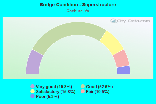
- Bridge Condition - Superstructure
- 15.8%Very good
- 52.6%Good
- 15.8%Satisfactory
- 10.5%Fair
- 5.3%Poor
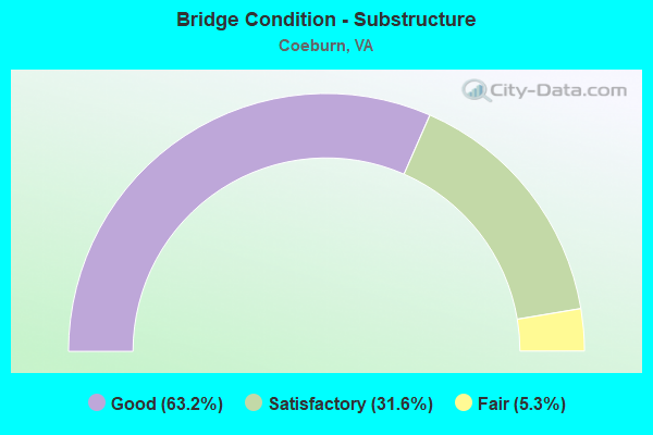
- Bridge Condition - Substructure
- 63.2%Good
- 31.6%Satisfactory
- 5.3%Fair
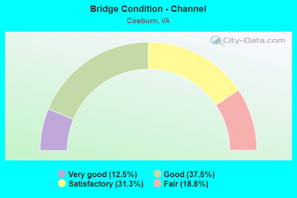
- Bridge Condition - Channel
- 12.5%Very good
- 37.5%Good
- 31.3%Satisfactory
- 18.8%Fair
Find on map >> Show street view
Structure Number: 19308, Location: .79M TO 58A & .01M TO 653 (Lat: 36.949758, Lng: -82.428800), Route carried "on" structure: County highway 893, Year Built: 1932, Year Reconstructed: 2019, Status: Open, Structure Length: 0.70m (2.30ft), Average Daily Traffic: 1,118 (year 2016), Average Future Daily Traffic: 1,252 (year 2040), Design Load: HL 93, Features Intersected: LITTLE TOMS CREEK, Facility Carried by Structure: BULL RUN RD.
Minimum Vertical Clearance: 30+ m (98+ ft), Kilometerpoint: 0.515, Lanes on structure: 2, Owner: State Highway Agency, Approaching Roadway Width: 7.5m (24.6ft), Material/Design: Concrete, Design/Construction: Slab, Number Of Spans In Main Unit: 1, Length of Maximum Span: 6.1m (20.0ft), Curb-To-Curb Width: 8.5m (27.9ft), Out-to-Out Width: 9.4m (30.8ft)
Condition: Deck: Very good, Superstructure: Very good, Substructure: Good, Channel: Fair, Operating Rating: 89.8 metric tons, Method Used To Determine Operating Rating: Load and Resistance Factor (LRFR), Inventory Rating: 82.6 metric tons, Method Used To Determine Inventory Rating: Load and Resistance Factor (LRFR), Structural Evaluation: Better than present minimum criteria, Deck Geometry: Somewhat better than minimum adequacy, Waterway Adequacy: Better than present minimum criteria, Approach Roadway Alignment: Better than present minimum criteria, Length Of Structure Improvement: 0.70m (2.30ft), Designated Inspection Frequency: Every 24 months, Inspection Date: December 2020, Deck Structure Type: Concrete Cast-file-Place, Wearing Surface/Protective System: Deck Protection: Other Coated Reinforcing
Find on map >> Show street view
Structure Number: 19324, Location: 2.69M TO 640& 2.9M to 649 (Lat: 37.017053, Lng: -82.485672), Route carried "on" structure: State highway 72, Year Built: 1931, Year Reconstructed: 2015, Status: Open, Structure Length: 1.58m (5.18ft), Average Daily Traffic: 541 (year 2020), Truck Traffic: 14%, Average Future Daily Traffic: 595 (year 2040), Design Load: HL 93, Features Intersected: TRACE CREEK, Facility Carried by Structure: CRANES NEST RD.
Minimum Vertical Clearance: 30+ m (98+ ft), Kilometerpoint: 60.677, Lanes on structure: 2, Base Highway Network: Yes, Owner: State Highway Agency, Approaching Roadway Width: 7.0m (23.0ft), Skew: 4 degrees, Material/Design: Prestressed concrete, Design/Construction: Box Beam or Girders - Multiple, Number Of Spans In Main Unit: 1, Length of Maximum Span: 14.6m (47.9ft), Curb-To-Curb Width: 7.9m (25.9ft), Out-to-Out Width: 8.5m (27.9ft)
Condition: Deck: Good, Superstructure: Very good, Substructure: Good, Channel: Satisfactory, Operating Rating: 77.1 metric tons, Method Used To Determine Operating Rating: Load and Resistance Factor (LRFR), Inventory Rating: 59.9 metric tons, Method Used To Determine Inventory Rating: Load and Resistance Factor (LRFR), Structural Evaluation: Better than present minimum criteria, Deck Geometry: Somewhat better than minimum adequacy, Waterway Adequacy: Better than present minimum criteria, Approach Roadway Alignment: Better than present minimum criteria, Length Of Structure Improvement: 1.46m (4.79ft), Designated Inspection Frequency: Every 24 months, Inspection Date: September 2021, Deck Structure Type: Concrete Cast-file-Place, Wearing Surface/Protective System: Deck Protection: Other Coated Reinforcing
Find on map >> Show street view
Structure Number: 19325, Location: 9.63MTODICK.CO&.45MTO58B. (Lat: 36.949097, Lng: -82.471286), Route carried "on" structure: State highway 72, Year Built: 1927, Year Reconstructed: 1995, Status: Open, Structure Length: 1.65m (5.41ft), Average Daily Traffic: 2,862 (year 2020), Truck Traffic: 14%, Average Future Daily Traffic: 3,148 (year 2040), Design Load: HS 20+Mod, Features Intersected: TOMS CREEK @ COEBURN, Facility Carried by Structure: LAUREL AVENUE
Minimum Vertical Clearance: 30+ m (98+ ft), Kilometerpoint: 51.280, Lanes on structure: 2, Owner: State Highway Agency, Approaching Roadway Width: 7.6m (24.9ft), Material/Design: Concrete, Design/Construction: Slab, Number Of Spans In Main Unit: 2, Length of Maximum Span: 7.6m (24.9ft), Curb or Sidewalk Widths: Left: 0.0m, Right: 1.2m (3.9ft), Curb-To-Curb Width: 7.9m (25.9ft), Out-to-Out Width: 9.1m (29.9ft)
Condition: Deck: Good, Superstructure: Good, Substructure: Fair, Channel: Satisfactory, Operating Rating: 89.8 metric tons, Method Used To Determine Operating Rating: Load and Resistance Factor (LRFR), Inventory Rating: 88.9 metric tons, Method Used To Determine Inventory Rating: Load and Resistance Factor (LRFR), Structural Evaluation: Somewhat better than minimum adequacy, Deck Geometry: High priority of corrective action, Waterway Adequacy: Better than present minimum criteria, Approach Roadway Alignment: Better than present minimum criteria, Length Of Structure Improvement: 1.55m (5.09ft), Designated Inspection Frequency: Every 24 months, Inspection Date: July 2021, Bridge Improvement Cost: $175,000, Roadway Improvement Cost: $25,000, Total Project Cost: $260,000 ( Estimate for 2019), Deck Structure Type: Concrete Cast-file-Place
Find on map >> Show street view
Structure Number: 19327, Location: .01M TO 158 & .41M TO 72 (Lat: 36.942969, Lng: -82.462781), Route carried "on" structure: County highway 884, Year Built: 1953, Year Reconstructed: 1987, Status: Open, Structure Length: 1.25m (4.10ft), Average Daily Traffic: 1,332 (year 2020), Truck Traffic: 1%, Average Future Daily Traffic: 1,465 (year 2040), Design Load: HS 20, Features Intersected: LITTLE TOMS CREEK, Facility Carried by Structure: QUILLEN AVE
Minimum Vertical Clearance: 30+ m (98+ ft), Kilometerpoint: 0.676, Lanes on structure: 2, Owner: State Highway Agency, Approaching Roadway Width: 8.5m (27.9ft), Material/Design: Concrete, Design/Construction: Slab, Number Of Spans In Main Unit: 1, Length of Maximum Span: 11.3m (37.1ft), Curb or Sidewalk Widths: Left: 1.2m (3.9ft), Right: 0.4m (1.3ft), Curb-To-Curb Width: 12.4m (40.7ft), Out-to-Out Width: 14.6m (47.9ft)
Condition: Deck: Satisfactory, Superstructure: Satisfactory, Substructure: Satisfactory, Channel: Fair, Operating Rating: 89.8 metric tons, Method Used To Determine Operating Rating: Load and Resistance Factor (LRFR), Inventory Rating: 84.4 metric tons, Method Used To Determine Inventory Rating: Load and Resistance Factor (LRFR), Structural Evaluation: Equal to present minimum criteria, Deck Geometry: Better than present minimum criteria, Waterway Adequacy: Better than present minimum criteria, Approach Roadway Alignment: Better than present minimum criteria, Designated Inspection Frequency: Every 24 months, Inspection Date: July 2021, Deck Structure Type: Concrete Cast-file-Place, Wearing Surface/Protective System: Wearing Surface: Bituminous
Find on map >> Show street view
Structure Number: 19328, Location: .85FR58A;4.84TOSCOTT CL (Lat: 36.929267, Lng: -82.456572), Route carried "on" structure: State highway 72, Year Built: 1959, Year Reconstructed: 1999, Status: Open, Structure Length: 4.69m (15.39ft), Average Daily Traffic: 1,404 (year 2020), Truck Traffic: 1%, Average Future Daily Traffic: 1,544 (year 2040), Design Load: HS 20+Mod, Features Intersected: GUEST RIVER @ COEBURN
Minimum Vertical Clearance: 30+ m (98+ ft), Kilometerpoint: 47.869, Lanes on structure: 2, Owner: State Highway Agency, Approaching Roadway Width: 7.9m (25.9ft), Material/Design: Concrete, Design/Construction: Slab, Number Of Spans In Main Unit: 4, Length of Maximum Span: 13.1m (43.0ft), Curb-To-Curb Width: 9.1m (29.9ft), Out-to-Out Width: 9.8m (32.2ft)
Condition: Deck: Good, Superstructure: Good, Substructure: Satisfactory, Channel: Satisfactory, Operating Rating: 53.5 metric tons, Method Used To Determine Operating Rating: Load and Resistance Factor (LRFR), Inventory Rating: 41.7 metric tons, Method Used To Determine Inventory Rating: Load and Resistance Factor (LRFR), Structural Evaluation: Equal to present minimum criteria, Deck Geometry: Somewhat better than minimum adequacy, Waterway Adequacy: Better than present minimum criteria, Approach Roadway Alignment: Better than present minimum criteria, Designated Inspection Frequency: Every 24 months, Inspection Date: May 2020, Deck Structure Type: Concrete Cast-file-Place, Wearing Surface/Protective System: Deck Protection: Epoxy Coated Reinforcing
Find on map >> Show street view
Structure Number: 19428, Location: 3.78 FR. 650; 0.61 TO 72 (Lat: 36.968042, Lng: -82.459658), Route carried "on" structure: County highway 652, Year Built: 1985, Status: Open, Structure Length: 1.13m (3.71ft), Average Daily Traffic: 1,682 (year 2020), Truck Traffic: 13%, Average Future Daily Traffic: 1,850 (year 2040), Design Load: HS 20+Mod, Features Intersected: TOMS CREEK, Facility Carried by Structure: TOMS CREEK ROAD
Minimum Vertical Clearance: 30+ m (98+ ft), Kilometerpoint: 0.970, Lanes on structure: 2, Owner: State Highway Agency, Approaching Roadway Width: 7.0m (23.0ft), Skew: 3 degrees, Material/Design: Concrete, Design/Construction: Slab, Number Of Spans In Main Unit: 1, Length of Maximum Span: 10.5m (34.4ft), Curb-To-Curb Width: 9.1m (29.9ft), Out-to-Out Width: 9.8m (32.2ft)
Condition: Deck: Fair, Superstructure: Fair, Substructure: Good, Channel: Satisfactory, Operating Rating: 74.4 metric tons, Method Used To Determine Operating Rating: Load and Resistance Factor (LRFR), Inventory Rating: 57.2 metric tons, Method Used To Determine Inventory Rating: Load and Resistance Factor (LRFR), Structural Evaluation: Somewhat better than minimum adequacy, Deck Geometry: Somewhat better than minimum adequacy, Waterway Adequacy: Better than present minimum criteria, Approach Roadway Alignment: Better than present minimum criteria, Designated Inspection Frequency: Every 24 months, Inspection Date: December 2021, Deck Structure Type: Concrete Cast-file-Place, Wearing Surface/Protective System: Wearing Surface: Bituminous
Find on map >> Show street view
Structure Number: 19432, Location: .03M TO 736&.02M TO 893 (Lat: 36.950042, Lng: -82.428667), Route carried "on" structure: County highway 653, Year Built: 1961, Status: Open, Structure Length: 0.67m (2.20ft), Average Daily Traffic: 653 (year 2016), Average Future Daily Traffic: 731 (year 2040), Design Load: H 20, Features Intersected: LITTLE TOMS CREEK, Facility Carried by Structure: LITTLE TOM RD.
Minimum Vertical Clearance: 30+ m (98+ ft), Kilometerpoint: 0.032, Lanes on structure: 2, Owner: State Highway Agency, Approaching Roadway Width: 6.1m (20.0ft), Material/Design: Concrete, Design/Construction: Slab, Number Of Spans In Main Unit: 1, Length of Maximum Span: 6.4m (21.0ft), Curb-To-Curb Width: 8.2m (26.9ft), Out-to-Out Width: 8.8m (28.9ft)
Condition: Deck: Fair, Superstructure: Fair, Substructure: Satisfactory, Channel: Fair, Operating Rating: 49.0 metric tons, Method Used To Determine Operating Rating: Load and Resistance Factor (LRFR), Inventory Rating: 38.1 metric tons, Method Used To Determine Inventory Rating: Load and Resistance Factor (LRFR), Structural Evaluation: Somewhat better than minimum adequacy, Deck Geometry: Somewhat better than minimum adequacy, Waterway Adequacy: Better than present minimum criteria, Approach Roadway Alignment: Better than present minimum criteria, Designated Inspection Frequency: Every 24 months, Inspection Date: December 2021, Deck Structure Type: Concrete Cast-file-Place, Wearing Surface/Protective System: Wearing Surface: Monolithic Concrete
Find on map >> Show street view
Structure Number: 19494, Location: .0M TO 756 & .08M TO 813 (Lat: 36.940111, Lng: -82.472511), Route carried "on" structure: County highway 1129, Year Built: 1927, Year Reconstructed: 1985, Status: Open, Structure Length: 1.25m (4.10ft), Average Daily Traffic: 2,099 (year 2016), Average Future Daily Traffic: 2,351 (year 2040), Design Load: HS 20+Mod, Features Intersected: TOMS CREEK, Facility Carried by Structure: MAY AVE.
Minimum Vertical Clearance: 30+ m (98+ ft), Kilometerpoint: 1.191, Lanes on structure: 2, Owner: State Highway Agency, Approaching Roadway Width: 6.4m (21.0ft), Skew: 3 degrees, Material/Design: Prestressed concrete, Design/Construction: Box Beam or Girders - Multiple, Number Of Spans In Main Unit: 1, Length of Maximum Span: 11.3m (37.1ft), Curb-To-Curb Width: 7.3m (24.0ft), Out-to-Out Width: 8.4m (27.6ft)
Condition: Deck: Good, Superstructure: Good, Substructure: Satisfactory, Channel: Good, Operating Rating: 58.1 metric tons, Method Used To Determine Operating Rating: Load and Resistance Factor (LRFR), Inventory Rating: 44.5 metric tons, Method Used To Determine Inventory Rating: Load and Resistance Factor (LRFR), Structural Evaluation: Equal to present minimum criteria, Deck Geometry: High priority of replacement, Waterway Adequacy: Better than present minimum criteria, Approach Roadway Alignment: Better than present minimum criteria, Length Of Structure Improvement: 1.25m (4.10ft), Designated Inspection Frequency: Every 24 months, Inspection Date: September 2021, Deck Structure Type: Concrete Precast Panels, Wearing Surface/Protective System: Wearing Surface: Bituminous, Membrane: Preformed Fabric
Find on map >> Show street view
Structure Number: 19495, Location: .10MTO72&.34MTOENDMAINT. (Lat: 36.955586, Lng: -82.470414), Route carried "on" structure: County highway 1135, Year Built: 1974, Status: Posted for load, Structure Length: 1.07m (3.51ft), Average Daily Traffic: 327 (year 2016), Average Future Daily Traffic: 484 (year 2040), Design Load: H 20, Features Intersected: TOM'S CREEK, Facility Carried by Structure: LITTLE LEAGUE RD.
Minimum Vertical Clearance: 30+ m (98+ ft), Kilometerpoint: 0.161, Lanes on structure: 1, Owner: State Highway Agency, Approaching Roadway Width: 4.9m (16.1ft), Material/Design: Steel, Design/Construction: Stringer/Multi-beam, Number Of Spans In Main Unit: 1, Length of Maximum Span: 10.7m (35.1ft), Curb or Sidewalk Widths: Left: 0.2m (0.7ft), Right: 0.2m (0.7ft), Curb-To-Curb Width: 5.4m (17.7ft), Out-to-Out Width: 5.9m (19.4ft)
Condition: Deck: Satisfactory, Superstructure: Poor, Substructure: Good, Channel: Good, Operating Rating: 35.4 metric tons, Method Used To Determine Operating Rating: Load and Resistance Factor (LRFR), Inventory Rating: 27.2 metric tons, Method Used To Determine Inventory Rating: Load and Resistance Factor (LRFR), Structural Evaluation: Meets minimum limits, Deck Geometry: High priority of replacement, Waterway Adequacy: Equal to present desirable criteria, Approach Roadway Alignment: Better than present minimum criteria, Length Of Structure Improvement: 1.07m (3.51ft), Designated Inspection Frequency: Every 24 months, Other Special Inspection Frequency: Every 12 months, Inspection Date: October 2021, Other Special Inspection Date: October 2021, Bridge Improvement Cost: $25,000, Roadway Improvement Cost: $5,000, Total Project Cost: $45,000 ( Estimate for 2019), Deck Structure Type: Concrete Cast-file-Place, Wearing Surface/Protective System: Wearing Surface: Bituminous
Find on map >> Show street view
Structure Number: 24447, Location: .1OTOBUS58A &.12TO0LD72 (Lat: 36.940489, Lng: -82.459872), Route carried "on" structure: State highway 72, Year Built: 1995, Status: Open, Structure Length: 6.46m (21.19ft), Average Daily Traffic: 1,661 (year 2020), Truck Traffic: 47%, Average Future Daily Traffic: 1,827 (year 2040), Design Load: HS 20, Features Intersected: ALTERNATE ROUTE 0058
Minimum Vertical Clearance: 30+ m (98+ ft), Kilometerpoint: 76.331, Lanes on structure: 6, Lanes under structure: 4, Base Highway Network: Yes, Owner: State Highway Agency, Approaching Roadway Width: 23.8m (78.1ft), Skew: 20 degrees, Material/Design: Steel, Design/Construction: Stringer/Multi-beam, Number Of Spans In Main Unit: 2, Length of Maximum Span: 32.0m (105.0ft), Curb-To-Curb Width: 25.6m (84.0ft), Out-to-Out Width: 26.6m (87.3ft)
Condition: Deck: Satisfactory, Superstructure: Satisfactory, Substructure: Good, Operating Rating: 68.9 metric tons, Method Used To Determine Operating Rating: Load and Resistance Factor (LRFR), Inventory Rating: 53.5 metric tons, Method Used To Determine Inventory Rating: Load and Resistance Factor (LRFR), Structural Evaluation: Equal to present minimum criteria, Deck Geometry: Somewhat better than minimum adequacy, Underclear: Equal to present minimum criteria, Approach Roadway Alignment: Superior to present desirable criteria, Designated Inspection Frequency: Every 24 months, Inspection Date: March 2020, Deck Structure Type: Concrete Cast-file-Place, Wearing Surface/Protective System: Deck Protection: Epoxy Coated Reinforcing
Find on map >> Show street view
Structure Number: 24504, Location: .15TORTE.72-.60TO58BUS (Lat: 36.940867, Lng: -82.463319), Route carried "on" structure: Alternate US 58, Year Built: 1995, Status: Open, Structure Length: 6.25m (20.51ft), Average Daily Traffic: 3,554 (year 2020), Truck Traffic: 6%, Average Future Daily Traffic: 4,976 (year 2040), Design Load: HS 20+Mod, Features Intersected: ROUTE 884 (QUILLEN AVE.), Facility Carried by Structure: NORTON-COEBURN RD.
Minimum Vertical Clearance: 30+ m (98+ ft), Kilometerpoint: 76.730, Lanes on structure: 2, Lanes under structure: 2, Base Highway Network: Yes, Owner: State Highway Agency, Approaching Roadway Width: 16.2m (53.1ft), Skew: 1 degrees, Material/Design: Prestressed concrete, Design/Construction: Stringer/Multi-beam, Number Of Spans In Main Unit: 3, Length of Maximum Span: 25.3m (83.0ft), Curb-To-Curb Width: 16.5m (54.1ft), Out-to-Out Width: 17.5m (57.4ft)
Condition: Deck: Good, Superstructure: Good, Substructure: Good, Operating Rating: 89.8 metric tons, Method Used To Determine Operating Rating: Load and Resistance Factor (LRFR), Inventory Rating: 63.5 metric tons, Method Used To Determine Inventory Rating: Load and Resistance Factor (LRFR), Structural Evaluation: Better than present minimum criteria, Deck Geometry: Superior to present desirable criteria, Underclear: Meets minimum limits, Approach Roadway Alignment: Equal to present desirable criteria, Designated Inspection Frequency: Every 24 months, Inspection Date: March 2020, Deck Structure Type: Concrete Cast-file-Place, Wearing Surface/Protective System: Wearing Surface: Monolithic Concrete, Deck Protection: Epoxy Coated Reinforcing
Find on map >> Show street view
Structure Number: 24505, Location: .15MTO 72&.80MTO58ABUS (Lat: 36.940686, Lng: -82.463350), Route carried "on" structure: Alternate US 58, Year Built: 1995, Status: Open, Structure Length: 6.25m (20.51ft), Average Daily Traffic: 3,554 (year 2020), Truck Traffic: 6%, Average Future Daily Traffic: 4,976 (year 2040), Design Load: HS 20+Mod, Features Intersected: RTE 884(QUILLEN AVE. SE), Facility Carried by Structure: NORTON-COEBURN RD
Minimum Vertical Clearance: 10.87m (35.66ft), Kilometerpoint: 76.730, Lanes on structure: 2, Lanes under structure: 2, Base Highway Network: Yes, Owner: State Highway Agency, Approaching Roadway Width: 16.2m (53.1ft), Skew: 1 degrees, Material/Design: Prestressed concrete, Design/Construction: Stringer/Multi-beam, Number Of Spans In Main Unit: 3, Length of Maximum Span: 25.3m (83.0ft), Curb-To-Curb Width: 16.5m (54.1ft), Out-to-Out Width: 17.5m (57.4ft)
Condition: Deck: Good, Superstructure: Good, Substructure: Satisfactory, Operating Rating: 89.8 metric tons, Method Used To Determine Operating Rating: Load and Resistance Factor (LRFR), Inventory Rating: 69.9 metric tons, Method Used To Determine Inventory Rating: Load and Resistance Factor (LRFR), Structural Evaluation: Equal to present minimum criteria, Deck Geometry: Superior to present desirable criteria, Underclear: Meets minimum limits, Approach Roadway Alignment: Equal to present desirable criteria, Designated Inspection Frequency: Every 24 months, Inspection Date: July 2020, Deck Structure Type: Concrete Cast-file-Place, Wearing Surface/Protective System: Wearing Surface: Monolithic Concrete, Deck Protection: Epoxy Coated Reinforcing
Find on map >> Show street view
Structure Number: 24516, Location: .05M TO 58ABUS&.05MTO58A (Lat: 36.941475, Lng: -82.459336), Route carried "on" structure: State highway 72, Year Built: 1995, Status: Open, Structure Length: 6.77m (22.21ft), Average Daily Traffic: 1,661 (year 2020), Truck Traffic: 47%, Average Future Daily Traffic: 1,827 (year 2040), Design Load: HS 20+Mod, Features Intersected: N&W RR & LITTLE TOMS CRK, Facility Carried by Structure: DUNGANON ROAD
Minimum Vertical Clearance: 30+ m (98+ ft), Kilometerpoint: 49.284, Lanes on structure: 4, Base Highway Network: Yes, Owner: State Highway Agency, Approaching Roadway Width: 20.1m (65.9ft), Skew: 20 degrees, Material/Design: Prestressed concrete, Design/Construction: Stringer/Multi-beam, Number Of Spans In Main Unit: 4, Length of Maximum Span: 18.3m (60.0ft), Curb-To-Curb Width: 25.6m (84.0ft), Out-to-Out Width: 26.5m (86.9ft)
Condition: Deck: Good, Superstructure: Good, Substructure: Good, Channel: Very good, Operating Rating: 47.2 metric tons, Method Used To Determine Operating Rating: Load and Resistance Factor (LRFR), Inventory Rating: 36.3 metric tons, Method Used To Determine Inventory Rating: Load and Resistance Factor (LRFR), Structural Evaluation: Better than present minimum criteria, Deck Geometry: Superior to present desirable criteria, Underclear: Equal to present minimum criteria, Waterway Adequacy: Superior to present desirable criteria, Approach Roadway Alignment: Equal to present desirable criteria, Designated Inspection Frequency: Every 24 months, Inspection Date: March 2020, Deck Structure Type: Concrete Cast-file-Place, Wearing Surface/Protective System: Deck Protection: Epoxy Coated Reinforcing
Find on map >> Show street view
Structure Number: 24553, Location: 1.09TOWCLCOEBURN-.70TOR72 (Lat: 36.940147, Lng: -82.474744), Route carried "on" structure: Alternate US 58, Year Built: 1995, Status: Open, Structure Length: 22.01m (72.21ft), Average Daily Traffic: 7,108 (year 2020), Truck Traffic: 6%, Average Future Daily Traffic: 7,819 (year 2040), Design Load: HS 20+Mod, Features Intersected: 2ndSt SW;NS;TomsCk;MayAV, Facility Carried by Structure: NORTON-COEBURN RD.
Minimum Vertical Clearance: 30+ m (98+ ft), Kilometerpoint: 74.931, Lanes on structure: 6, Lanes under structure: 4, Base Highway Network: Yes, Owner: State Highway Agency, Approaching Roadway Width: 11.0m (36.1ft), Skew: 33 degrees, Material/Design: Steel continuous, Design/Construction: Stringer/Multi-beam, Number Of Spans In Main Unit: 5, Length of Maximum Span: 51.8m (169.9ft), Curb-To-Curb Width: 31.6m (103.7ft), Out-to-Out Width: 33.5m (109.9ft)
Condition: Deck: Satisfactory, Superstructure: Good, Substructure: Good, Channel: Good, Operating Rating: 42.6 metric tons, Method Used To Determine Operating Rating: Load and Resistance Factor (LRFR), Inventory Rating: 33.6 metric tons, Method Used To Determine Inventory Rating: Load and Resistance Factor (LRFR), Structural Evaluation: Better than present minimum criteria, Deck Geometry: Superior to present desirable criteria, Underclear: Somewhat better than minimum adequacy, Waterway Adequacy: Superior to present desirable criteria, Approach Roadway Alignment: Equal to present desirable criteria, Length Of Structure Improvement: 0.03m (0.10ft), Designated Inspection Frequency: Every 24 months, Inspection Date: July 2020, Bridge Improvement Cost: $1,000, Roadway Improvement Cost: $1,000, Total Project Cost: $3,000 ( Estimate for 2014), Deck Structure Type: Concrete Cast-file-Place, Wearing Surface/Protective System: Wearing Surface: Monolithic Concrete, Deck Protection: Epoxy Coated Reinforcing
Find on map >> Show street view
Structure Number: 24988, Location: .01MTO 58A &.01MTOOLD58A (Lat: 36.948492, Lng: -82.434103), Route carried "on" structure: State highway 158, Year Built: 1997, Status: Open, Structure Length: 6.16m (20.21ft), Average Daily Traffic: 298 (year 2020), Truck Traffic: 1%, Average Future Daily Traffic: 417 (year 2040), Design Load: HS 20+Mod, Features Intersected: N&S R.R. & LITTLETOMSCR.
Minimum Vertical Clearance: 30+ m (98+ ft), Kilometerpoint: 4.280, Lanes on structure: 1, Owner: State Highway Agency, Approaching Roadway Width: 12.2m (40.0ft), Material/Design: Steel, Design/Construction: Stringer/Multi-beam, Number Of Spans In Main Unit: 4, Length of Maximum Span: 18.3m (60.0ft), Curb-To-Curb Width: 12.3m (40.4ft), Out-to-Out Width: 13.4m (44.0ft)
Condition: Deck: Good, Superstructure: Satisfactory, Substructure: Good, Channel: Good, Operating Rating: 69.9 metric tons, Method Used To Determine Operating Rating: Load and Resistance Factor (LRFR), Inventory Rating: 54.4 metric tons, Method Used To Determine Inventory Rating: Load and Resistance Factor (LRFR), Structural Evaluation: Equal to present minimum criteria, Deck Geometry: Superior to present desirable criteria, Underclear: Better than present minimum criteria, Waterway Adequacy: Superior to present desirable criteria, Approach Roadway Alignment: Equal to present desirable criteria, Designated Inspection Frequency: Every 24 months, Inspection Date: August 2021, Deck Structure Type: Concrete Cast-file-Place, Wearing Surface/Protective System: Deck Protection: Epoxy Coated Reinforcing
Find on map >> Show street view
Structure Number: 25462, Location: .15M TO 58A & .03M TO 72 (Lat: 36.944839, Lng: -82.470228), Route carried "on" structure: County highway 1102, Year Built: 1998, Status: Open, Structure Length: 1.71m (5.61ft), Average Daily Traffic: 587 (year 2016), Average Future Daily Traffic: 657 (year 2040), Design Load: HS 20+Mod, Features Intersected: TOM'S CREEK
Minimum Vertical Clearance: 30+ m (98+ ft), Kilometerpoint: 0.209, Lanes on structure: 2, Owner: State Highway Agency, Approaching Roadway Width: 7.9m (25.9ft), Material/Design: Wood or Timber, Design/Construction: Tee Beam, Number Of Spans In Main Unit: 2, Length of Maximum Span: 8.5m (27.9ft), Curb or Sidewalk Widths: Left: 0.3m (1.0ft), Right: 0.3m (1.0ft), Curb-To-Curb Width: 8.0m (26.2ft), Out-to-Out Width: 8.6m (28.2ft)
Condition: Deck: Good, Superstructure: Good, Substructure: Good, Channel: Good, Operating Rating: 49.9 metric tons, Method Used To Determine Operating Rating: Load Factor (LF), Inventory Rating: 35.4 metric tons, Method Used To Determine Inventory Rating: Load Factor (LF), Structural Evaluation: Better than present minimum criteria, Deck Geometry: Somewhat better than minimum adequacy, Waterway Adequacy: Better than present minimum criteria, Approach Roadway Alignment: Better than present minimum criteria, Designated Inspection Frequency: Every 24 months, Inspection Date: August 2020, Deck Structure Type: Wood or Timber, Wearing Surface/Protective System: Wearing Surface: Bituminous
Find on map >> Show street view
Structure Number: 28351, Location: .14M TOT1101& .01M TO646 (Lat: 36.946231, Lng: -82.471486), Route carried "on" structure: State highway 72, Year Built: 2006, Status: Open, Structure Length: 2.99m (9.81ft), Average Daily Traffic: 2,862 (year 2020), Truck Traffic: 14%, Average Future Daily Traffic: 3,148 (year 2040), Design Load: HS 20+Mod, Features Intersected: TOMS CREEK, Facility Carried by Structure: LAUREL AVENUE
Minimum Vertical Clearance: 30+ m (98+ ft), Kilometerpoint: 50.949, Lanes on structure: 2, Owner: State Highway Agency, Approaching Roadway Width: 9.4m (30.8ft), Skew: 4 degrees, Material/Design: Concrete, Design/Construction: Slab, Number Of Spans In Main Unit: 2, Length of Maximum Span: 14.9m (48.9ft), Curb or Sidewalk Widths: Left: 0.0m, Right: 1.5m (4.9ft), Curb-To-Curb Width: 12.2m (40.0ft), Out-to-Out Width: 14.5m (47.6ft)
Condition: Deck: Good, Superstructure: Good, Substructure: Good, Channel: Satisfactory, Operating Rating: 89.8 metric tons, Method Used To Determine Operating Rating: Load and Resistance Factor (LRFR), Inventory Rating: 86.2 metric tons, Method Used To Determine Inventory Rating: Load and Resistance Factor (LRFR), Structural Evaluation: Better than present minimum criteria, Deck Geometry: Equal to present minimum criteria, Waterway Adequacy: Better than present minimum criteria, Approach Roadway Alignment: Better than present minimum criteria, Designated Inspection Frequency: Every 24 months, Inspection Date: May 2020, Deck Structure Type: Concrete Cast-file-Place, Wearing Surface/Protective System: Deck Protection: Epoxy Coated Reinforcing
Find on map >> Show street view
Structure Number: 30033, Location: 0.02 Fr SR-72(Laurel Ave) (Lat: 36.950486, Lng: -82.470664), Route carried "on" structure: City street , Year Built: 1932, Year Reconstructed: 2012, Status: Open, Structure Length: 0.98m (3.22ft), Average Daily Traffic: 30 (year 2000), Average Future Daily Traffic: 45 (year 2039), Design Load: HL 93, Features Intersected: TOMS CREEK, Facility Carried by Structure: LINCOLN ST NE
Minimum Vertical Clearance: 30+ m (98+ ft), Kilometerpoint: 0.000, Lanes on structure: 1, Owner: Town or Township Highway Agency, Approaching Roadway Width: 3.8m (12.5ft), Skew: 1 degrees, Material/Design: Prestressed concrete, Design/Construction: Box Beam or Girders - Multiple, Number Of Spans In Main Unit: 1, Length of Maximum Span: 9.1m (29.9ft), Curb-To-Curb Width: 3.8m (12.5ft), Out-to-Out Width: 4.0m (13.1ft)
Condition: Deck: Good, Superstructure: Good, Substructure: Satisfactory, Channel: Good, Operating Rating: 89.8 metric tons, Method Used To Determine Operating Rating: Load and Resistance Factor (LRFR), Inventory Rating: 84.4 metric tons, Method Used To Determine Inventory Rating: Load and Resistance Factor (LRFR), Structural Evaluation: Equal to present minimum criteria, Deck Geometry: Meets minimum limits, Waterway Adequacy: Equal to present minimum criteria, Approach Roadway Alignment: Equal to present desirable criteria, Length Of Structure Improvement: 0.98m (3.22ft), Designated Inspection Frequency: Every 24 months, Inspection Date: September 2020, Deck Structure Type: Other
Find on map >> Show street view
Structure Number: 30587, Location: .61M TO 72E & .04M TO 72W (Lat: 36.942972, Lng: -82.469678), Route carried "on" structure: State highway 158, Year Built: 2017, Status: Open, Structure Length: 1.40m (4.59ft), Average Daily Traffic: 3,073 (year 2020), Truck Traffic: 1%, Average Future Daily Traffic: 3,380 (year 2040), Design Load: HL 93, Features Intersected: TOMS CREEK
Minimum Vertical Clearance: 30+ m (98+ ft), Kilometerpoint: 0.933, Lanes on structure: 2, Owner: State Highway Agency, Approaching Roadway Width: 7.3m (24.0ft), Material/Design: Prestressed concrete, Design/Construction: Box Beam or Girders - Multiple, Number Of Spans In Main Unit: 1, Length of Maximum Span: 13.1m (43.0ft), Curb or Sidewalk Widths: Left: 0.0m, Right: 1.9m (6.2ft), Curb-To-Curb Width: 11.0m (36.1ft), Out-to-Out Width: 13.4m (44.0ft)
Condition: Deck: Good, Superstructure: Very good, Substructure: Good, Channel: Very good, Operating Rating: 89.8 metric tons, Method Used To Determine Operating Rating: Load and Resistance Factor (LRFR), Inventory Rating: 64.4 metric tons, Method Used To Determine Inventory Rating: Load and Resistance Factor (LRFR), Structural Evaluation: Better than present minimum criteria, Deck Geometry: Somewhat better than minimum adequacy, Waterway Adequacy: Equal to present desirable criteria, Approach Roadway Alignment: Equal to present desirable criteria, Designated Inspection Frequency: Every 24 months, Inspection Date: June 2021, Deck Structure Type: Concrete Cast-file-Place, Wearing Surface/Protective System: Deck Protection: Other Coated Reinforcing
Find on map >> Show street view
Structure Number: 24447, Location: .1OTOBUS58A &.12TO0LD72 (Lat: 36.940489, Lng: -82.459872), Route carried "under" structure: US 58, Year Built: 1995, Structure Length: 0. m, Average Daily Traffic: 7,291 (year 2008), Truck Traffic: 6%, Features Intersected: ALTERNATE ROUTE 0058, Facility Carried by Structure: ROUTE 0072
Minimum Vertical Clearance: 7.03m (23.06ft), Kilometerpoint: 76.331, Lanes on structure: 6, Lanes under structure: 4, Material/Design: Steel, Design/Construction: Stringer/Multi-beam, Length of Maximum Span: 32.0m (105.0ft)
Find on map >> Show street view
Structure Number: 24504, Location: .15TORTE.72-.60TO58BUS (Lat: 36.940867, Lng: -82.463319), Route carried "under" structure: County highway 884, Year Built: 1995, Structure Length: 0. m, Average Daily Traffic: 1,300 (year 2018), Truck Traffic: 1%, Features Intersected: ROUTE 884 (QUILLEN AVE.), Facility Carried by Structure: NORTON-COEBURN RD.
Minimum Vertical Clearance: 12.90m (42.32ft), Kilometerpoint: 0.483, Lanes on structure: 2, Lanes under structure: 2, Material/Design: Prestressed concrete, Design/Construction: Stringer/Multi-beam, Length of Maximum Span: 25.3m (83.0ft)
Find on map >> Show street view
Structure Number: 24505, Location: .15MTO 72&.80MTO58ABUS (Lat: 36.940686, Lng: -82.463350), Route carried "under" structure: County highway 884, Year Built: 1995, Structure Length: 0. m, Average Daily Traffic: 2,331 (year 2007), Features Intersected: RTE 884(QUILLEN AVE. SE), Facility Carried by Structure: NORTON-COEBURN RD
Minimum Vertical Clearance: 10.90m (35.76ft), Kilometerpoint: 0.386, Lanes on structure: 2, Lanes under structure: 2, Material/Design: Prestressed concrete, Design/Construction: Stringer/Multi-beam, Length of Maximum Span: 25.3m (83.0ft)
Find on map >> Show street view
Structure Number: 24553, Location: 1.09TOWCLCOEBURN-.70TOR72 (Lat: 36.940147, Lng: -82.474744), Route carried "under" structure: City street 1129, Year Built: 1995, Structure Length: 0. m, Average Daily Traffic: 2,939 (year 2007), Features Intersected: 2ndSt SW;NS;TomsCk;MayAV, Facility Carried by Structure: NORTON-COEBURN RD.
Minimum Vertical Clearance: 9.47m (31.07ft), Kilometerpoint: 1.191, Lanes on structure: 6, Lanes under structure: 2, Material/Design: Steel continuous, Design/Construction: Stringer/Multi-beam, Length of Maximum Span: 51.8m (169.9ft)
Find on map >> Show street view
Structure Number: 24553, Location: 1.09TOWCLCOEBURN-.70TOR72 (Lat: 36.940147, Lng: -82.474744), Route carried "under" structure: City street 813, Year Built: 1995, Structure Length: 0. m, Average Daily Traffic: 4,157 (year 2008), Truck Traffic: 35%, Features Intersected: 2ndSt SW;NS;TomsCk;MayAV, Facility Carried by Structure: NORTON-COEBURN RD.
Minimum Vertical Clearance: 5.23m (17.16ft), Kilometerpoint: 0.000, Lanes on structure: 6, Lanes under structure: 2, Material/Design: Steel continuous, Design/Construction: Stringer/Multi-beam, Length of Maximum Span: 51.8m (169.9ft)