Bridge Statistics for Concord, Michigan (MI)
Condition, Traffic, Stress, Structural Evaluation, Project Costs
- National Bridge Inventory (NBI) Statistics
- 19Number of bridges
- 98ft / 29.9mTotal length
- $565,000Total costs
- 265,321Total average daily traffic
- 12,517Total average daily truck traffic
- National Bridge Inventory (NBI) Registered Bridges for Concord
- No street view available for this location
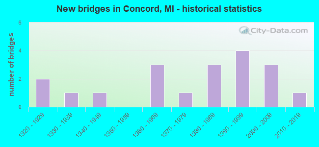
- New bridges - historical statistics
- 21920-1929
- 11930-1939
- 11940-1949
- 31960-1969
- 11970-1979
- 31980-1989
- 41990-1999
- 32000-2009
- 12010-2019
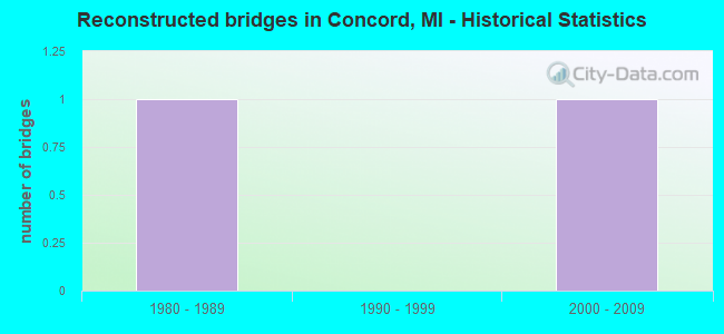
- Reconstructed bridges - Historical Statistics
- 11980-1989
- 01990-1999
- 12000-2009
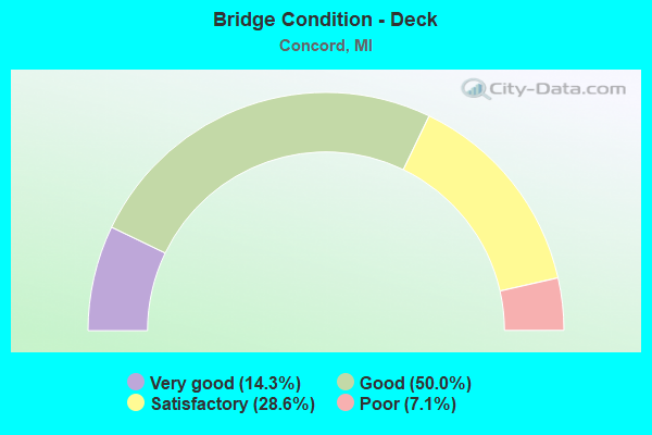
- Bridge Condition - Deck
- 14.3%Very good
- 50.0%Good
- 28.6%Satisfactory
- 7.1%Poor
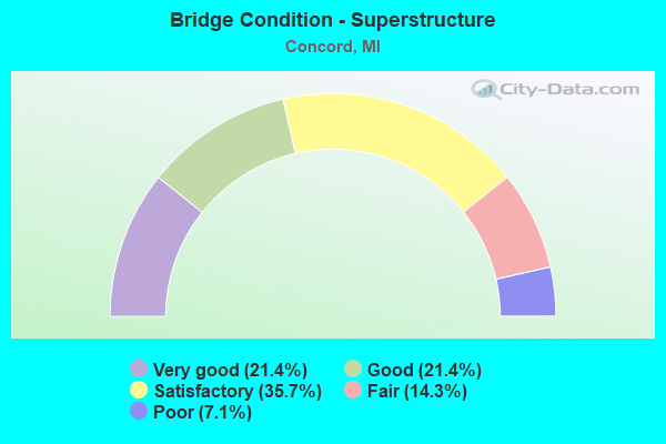
- Bridge Condition - Superstructure
- 21.4%Very good
- 21.4%Good
- 35.7%Satisfactory
- 14.3%Fair
- 7.1%Poor
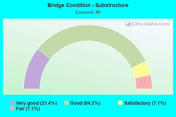
- Bridge Condition - Substructure
- 21.4%Very good
- 64.3%Good
- 7.1%Satisfactory
- 7.1%Fair
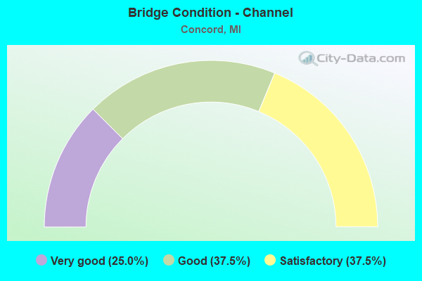
- Bridge Condition - Channel
- 25.0%Very good
- 37.5%Good
- 37.5%Satisfactory
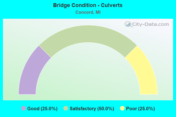
- Bridge Condition - Culverts
- 25.0%Good
- 50.0%Satisfactory
- 25.0%Poor
Find on map >> Show street view
Structure Number: 65, Location: 0.25 MI N W BRANCH LAKE (Lat: 46.170333, Lng: -86.739036), Route carried "on" structure: County highway , Year Built: 1949, Year Reconstructed: 2000, Status: Open, Structure Length: 0.82m (2.69ft), Average Daily Traffic: 191 (year 1998), Truck Traffic: 1%, Average Future Daily Traffic: 240 (year 2018), Design Load: HS 25 or greater, Features Intersected: WEST BRANCH CREEK, Facility Carried by Structure: ROUND LAKE RD FH78
Minimum Vertical Clearance: 30.48m (100.00ft), Kilometerpoint: 2.018, Lanes on structure: 2, Owner: County Highway Agency, Approaching Roadway Width: 7.3m (24.0ft), Material/Design: Wood or Timber, Design/Construction: Stringer/Multi-beam, Number Of Spans In Main Unit: 1, Length of Maximum Span: 8.2m (26.9ft), Curb-To-Curb Width: 7.3m (24.0ft), Out-to-Out Width: 7.6m (24.9ft)
Condition: Deck: Very good, Superstructure: Very good, Substructure: Very good, Channel: Good, Operating Rating: 97.2 metric tons, Method Used To Determine Operating Rating: Allowable Stress (AS) rating reported by rating factor (RF) method using MS18 loading, Inventory Rating: 97.2 metric tons, Method Used To Determine Inventory Rating: Allowable Stress (AS) rating reported by rating factor (RF) method using MS18 loading, Structural Evaluation: Equal to present desirable criteria, Deck Geometry: Somewhat better than minimum adequacy, Waterway Adequacy: Better than present minimum criteria, Approach Roadway Alignment: Equal to present minimum criteria, Designated Inspection Frequency: Every 24 months, Inspection Date: September 2021, Deck Structure Type: Wood or Timber, Wearing Surface/Protective System: Wearing Surface: Bituminous
Find on map >> Show street view
Structure Number: 235, Location: DORR TWP SEC 18 (Lat: 42.737147, Lng: -85.771569), Route carried "on" structure: County highway , Year Built: 2006, Status: Open, Structure Length: 1.52m (4.99ft), Average Daily Traffic: 87 (year 2005), Truck Traffic: 5%, Average Future Daily Traffic: 130 (year 2025), Design Load: HS 20, Features Intersected: LITTLE RABBIT RIVER DRN, Facility Carried by Structure: 23RD STREET
Minimum Vertical Clearance: 30+ m (98+ ft), Kilometerpoint: 1.329, Lanes on structure: 2, Owner: County Highway Agency, Approaching Roadway Width: 9.8m (32.2ft), Material/Design: Prestressed concrete, Design/Construction: Box Beam or Girders - Multiple, Number Of Spans In Main Unit: 1, Length of Maximum Span: 14.0m (45.9ft), Curb-To-Curb Width: 9.8m (32.2ft), Out-to-Out Width: 10.1m (33.1ft)
Condition: Deck: Satisfactory, Superstructure: Satisfactory, Substructure: Very good, Channel: Satisfactory, Operating Rating: 97.2 metric tons, Method Used To Determine Operating Rating: Load Factor (LF) rating reported by rating factor (RF) method using MS18 loading, Inventory Rating: 72.9 metric tons, Method Used To Determine Inventory Rating: Load Factor (LF) rating reported by rating factor (RF) method using MS18 loading, Structural Evaluation: Equal to present minimum criteria, Deck Geometry: Equal to present desirable criteria, Waterway Adequacy: Equal to present desirable criteria, Approach Roadway Alignment: Equal to present desirable criteria, Designated Inspection Frequency: Every 24 months, Inspection Date: April 2021, Deck Structure Type: Concrete Cast-file-Place, Wearing Surface/Protective System: Wearing Surface: Integral Concrete, Deck Protection: Epoxy Coated Reinforcing
Find on map >> Show street view
Structure Number: 263, Location: APPROX 1/4MI S OF 128TH A (Lat: 42.611508, Lng: -85.682700), Route carried "on" structure: County highway , Year Built: 1969, Status: Open, Structure Length: 0.66m (2.17ft), Average Daily Traffic: 100 (year 2002), Truck Traffic: 7%, Average Future Daily Traffic: 200 (year 2022), Design Load: H 20, Features Intersected: MILLER CREEK, Facility Carried by Structure: 14TH STREET
Minimum Vertical Clearance: 30.48m (100.00ft), Kilometerpoint: 3.829, Lanes on structure: 2, Owner: County Highway Agency, Approaching Roadway Width: 6.1m (20.0ft), Material/Design: Steel, Design/Construction: Culvert, Number Of Spans In Main Unit: 2, Length of Maximum Span: 2.6m (8.5ft)
Condition: Channel: Satisfactory, Culverts: Poor, Operating Rating: 23.3 metric tons, Method Used To Determine Operating Rating: Load Factor (LF) rating reported by rating factor (RF) method using MS18 loading, Inventory Rating: 13.9 metric tons, Method Used To Determine Inventory Rating: Load Factor (LF) rating reported by rating factor (RF) method using MS18 loading, Structural Evaluation: Meets minimum limits, Waterway Adequacy: Equal to present minimum criteria, Approach Roadway Alignment: Equal to present desirable criteria, Designated Inspection Frequency: Every 24 months, Inspection Date: May 2021
Find on map >> Show street view
Structure Number: 579, Location: 0.29 MI SW OF I-75 JCT (Lat: 43.555686, Lng: -83.951403), Route carried "on" structure: State highway 84, Year Built: 2009, Status: Open, Structure Length: 1.86m (6.10ft), Average Daily Traffic: 19,900 (year 2010), Truck Traffic: 2%, Average Future Daily Traffic: 22,000 (year 2030), Design Load: Greater than HL93, Features Intersected: SQUACONNING CREEK
Minimum Vertical Clearance: 30.48m (100.00ft), Kilometerpoint: 4.077, Lanes on structure: 2, Base Highway Network: Yes (Inventory Route: 76, Subroute: 10), Owner: State Highway Agency, Approaching Roadway Width: 21.9m (71.9ft), Material/Design: Prestressed concrete, Design/Construction: Box Beam or Girders - Single/Spread, Number Of Spans In Main Unit: 1, Length of Maximum Span: 17.7m (58.1ft), Curb-To-Curb Width: 24.7m (81.0ft), Out-to-Out Width: 25.5m (83.7ft)
Condition: Deck: Good, Superstructure: Very good, Substructure: Good, Channel: Very good, Operating Rating: 69.1 metric tons, Method Used To Determine Operating Rating: Load Factor (LF), Inventory Rating: 37.1 metric tons, Method Used To Determine Inventory Rating: Load Factor (LF), Structural Evaluation: Better than present minimum criteria, Deck Geometry: Superior to present desirable criteria, Waterway Adequacy: Equal to present desirable criteria, Approach Roadway Alignment: Equal to present minimum criteria, Designated Inspection Frequency: Every 24 months, Inspection Date: March 2021, Deck Structure Type: Concrete Cast-file-Place, Wearing Surface/Protective System: Wearing Surface: Monolithic Concrete, Deck Protection: Epoxy Coated Reinforcing
Find on map >> Show street view
Structure Number: 1044, Location: 4 MI E OF NEW TROY (Lat: 41.873083, Lng: -86.475050), Route carried "on" structure: County highway , Year Built: 1990, Status: Open, Structure Length: 0.70m (2.30ft), Average Daily Traffic: 296 (year 2007), Truck Traffic: 4%, Average Future Daily Traffic: 400 (year 2027), Design Load: HS 20, Features Intersected: E BR GALIEN RIVER, Facility Carried by Structure: GARDNER ROAD
Minimum Vertical Clearance: 30.48m (100.00ft), Kilometerpoint: 8.401, Lanes on structure: 2, Owner: County Highway Agency, Approaching Roadway Width: 9.1m (29.9ft), Skew: 1 degrees, Material/Design: Concrete, Design/Construction: Culvert, Number Of Spans In Main Unit: 1, Length of Maximum Span: 6.1m (20.0ft)
Condition: Channel: Satisfactory, Culverts: Satisfactory, Operating Rating: 54.5 metric tons, Method Used To Determine Operating Rating: Field evaluation and documented engineering judgment, Inventory Rating: 32.7 metric tons, Method Used To Determine Inventory Rating: Field evaluation and documented engineering judgment, Structural Evaluation: Equal to present minimum criteria, Waterway Adequacy: Equal to present desirable criteria, Approach Roadway Alignment: Equal to present desirable criteria, Designated Inspection Frequency: Every 24 months, Inspection Date: July 2020
Find on map >> Show street view
Structure Number: 2089, Location: 0.2 MI E OF US-41 (Lat: 45.926611, Lng: -86.971456), Route carried "on" structure: US 2, Year Built: 1990, Status: Open, Structure Length: 1.06m (3.48ft), Average Daily Traffic: 8,505 (year 2007), Truck Traffic: 8%, Average Future Daily Traffic: 11,941 (year 2018), Design Load: HS 25 or greater, Features Intersected: TOCOOSH CREEK
Minimum Vertical Clearance: 30.48m (100.00ft), Kilometerpoint: 52.180, Lanes on structure: 4, Base Highway Network: Yes (Inventory Route: 134, Subroute: 6), Owner: State Highway Agency, Approaching Roadway Width: 15.9m (52.2ft), Material/Design: Prestressed concrete, Design/Construction: Box Beam or Girders - Multiple, Number Of Spans In Main Unit: 1, Length of Maximum Span: 10.6m (34.8ft), Curb or Sidewalk Widths: Left: 1.5m (4.9ft), Right: 1.5m (4.9ft), Curb-To-Curb Width: 15.9m (52.2ft), Out-to-Out Width: 19.6m (64.3ft)
Condition: Deck: Satisfactory, Superstructure: Satisfactory, Substructure: Good, Channel: Good, Operating Rating: 85.9 metric tons, Method Used To Determine Operating Rating: Load Factor (LF) rating reported by rating factor (RF) method using MS18 loading, Inventory Rating: 40.2 metric tons, Method Used To Determine Inventory Rating: Load Factor (LF) rating reported by rating factor (RF) method using MS18 loading, Structural Evaluation: Equal to present minimum criteria, Deck Geometry: Meets minimum limits, Waterway Adequacy: Equal to present desirable criteria, Approach Roadway Alignment: Equal to present desirable criteria, Designated Inspection Frequency: Every 24 months, Inspection Date: September 2021, Deck Structure Type: Concrete Cast-file-Place, Wearing Surface/Protective System: Wearing Surface: Latex Concrete, Deck Protection: Epoxy Coated Reinforcing
Find on map >> Show street view
Structure Number: 2629, Location: 3.0 MI NW OF OAKLAND COL (Lat: 42.902728, Lng: -83.647031), Route carried "on" structure: Interstate 75, Year Built: 1962, Year Reconstructed: 1985, Status: Open, Structure Length: 3.59m (11.78ft), Average Daily Traffic: 40,700 (year 2013), Truck Traffic: 6%, Average Future Daily Traffic: 38,551 (year 2018), Design Load: HS 20+Mod, Features Intersected: COOK RD
Minimum Vertical Clearance: 30.48m (100.00ft), Kilometerpoint: 5.425, Lanes on structure: 4, Lanes under structure: 2, Base Highway Network: Yes (Inventory Route: 149, Subroute: 4), Owner: State Highway Agency, Approaching Roadway Width: 17.0m (55.8ft), Skew: 2 degrees, Material/Design: Steel, Design/Construction: Stringer/Multi-beam, Number Of Spans In Main Unit: 3, Length of Maximum Span: 13.4m (44.0ft), Curb-To-Curb Width: 18.4m (60.4ft), Out-to-Out Width: 19.8m (65.0ft)
Condition: Deck: Satisfactory, Superstructure: Fair, Substructure: Good, Operating Rating: 54.8 metric tons, Method Used To Determine Operating Rating: Load Factor (LF) rating reported by rating factor (RF) method using MS18 loading, Inventory Rating: 32.7 metric tons, Method Used To Determine Inventory Rating: Load Factor (LF) rating reported by rating factor (RF) method using MS18 loading, Structural Evaluation: Somewhat better than minimum adequacy, Deck Geometry: Meets minimum limits, Underclear: Meets minimum limits, Approach Roadway Alignment: Equal to present minimum criteria, Designated Inspection Frequency: Every 13 months, Inspection Date: May 2021, Deck Structure Type: Concrete Cast-file-Place, Wearing Surface/Protective System: Wearing Surface: Epoxy Overlay
Find on map >> Show street view
Structure Number: 3243, Location: SEC 6-7 SUMNER TWP (Lat: 43.364911, Lng: -84.839494), Route carried "on" structure: County highway , Year Built: 2003, Status: Open, Structure Length: 2.87m (9.42ft), Average Daily Traffic: 288 (year 2004), Average Future Daily Traffic: 380 (year 2024), Design Load: HS 25 or greater, Features Intersected: PINE RIVER, Facility Carried by Structure: VAN BUREN ROAD
Minimum Vertical Clearance: 30.48m (100.00ft), Kilometerpoint: 0.454, Lanes on structure: 2, Owner: County Highway Agency, Approaching Roadway Width: 9.1m (29.9ft), Skew: 2 degrees, Material/Design: Prestressed concrete, Design/Construction: Box Beam or Girders - Multiple, Number Of Spans In Main Unit: 1, Length of Maximum Span: 27.4m (89.9ft), Curb-To-Curb Width: 9.1m (29.9ft), Out-to-Out Width: 10.1m (33.1ft)
Condition: Deck: Good, Superstructure: Good, Substructure: Good, Channel: Very good, Inventory Rating: 80.0 metric tons, Method Used To Determine Inventory Rating: Load Factor (LF), Structural Evaluation: Better than present minimum criteria, Deck Geometry: Equal to present minimum criteria, Waterway Adequacy: Equal to present desirable criteria, Approach Roadway Alignment: Equal to present desirable criteria, Designated Inspection Frequency: Every 24 months, Inspection Date: July 2020, Deck Structure Type: Concrete Cast-file-Place, Wearing Surface/Protective System: Wearing Surface: Monolithic Concrete, Deck Protection: Epoxy Coated Reinforcing
Find on map >> Show street view
Structure Number: 439, Location: IN CONCORD (Lat: 42.179728, Lng: -84.649378), Route carried "on" structure: State highway 60, Year Built: 1932, Status: Open, Structure Length: 0.94m (3.08ft), Average Daily Traffic: 4,322 (year 2007), Truck Traffic: 27%, Average Future Daily Traffic: 5,245 (year 2018), Design Load: H 15, Features Intersected: N BR KALAMAZOO RIVER
Minimum Vertical Clearance: 30.48m (100.00ft), Kilometerpoint: 5.739, Lanes on structure: 2, Base Highway Network: Yes (Inventory Route: 89, Subroute: 7), Owner: State Highway Agency, Approaching Roadway Width: 12.2m (40.0ft), Skew: 3 degrees, Material/Design: Concrete, Design/Construction: Tee Beam, Number Of Spans In Main Unit: 1, Length of Maximum Span: 9.4m (30.8ft), Curb-To-Curb Width: 12.2m (40.0ft), Out-to-Out Width: 23.6m (77.4ft)
Condition: Deck: Good, Superstructure: Satisfactory, Substructure: Satisfactory, Channel: Good, Operating Rating: 57.3 metric tons, Method Used To Determine Operating Rating: Load Factor (LF) rating reported by rating factor (RF) method using MS18 loading, Inventory Rating: 34.3 metric tons, Method Used To Determine Inventory Rating: Load Factor (LF) rating reported by rating factor (RF) method using MS18 loading, Structural Evaluation: Equal to present minimum criteria, Deck Geometry: Equal to present minimum criteria, Waterway Adequacy: Equal to present desirable criteria, Approach Roadway Alignment: Equal to present desirable criteria, Designated Inspection Frequency: Every 24 months, Inspection Date: May 2021, Deck Structure Type: Concrete Cast-file-Place, Wearing Surface/Protective System: Wearing Surface: Bituminous
Find on map >> Show street view
Structure Number: 4473, Location: 2.3 MILES NORTH CONCORD (Lat: 42.214275, Lng: -84.665081), Route carried "on" structure: County highway , Year Built: 1987, Status: Posted for load, Structure Length: 1.34m (4.40ft), Average Daily Traffic: 590 (year 2003), Average Future Daily Traffic: 650 (year 2010), Design Load: HS 20+Mod, Features Intersected: N BRANCH KALAMAZOO RIVER, Facility Carried by Structure: KING ROAD
Minimum Vertical Clearance: 30.48m (100.00ft), Kilometerpoint: 0.240, Lanes on structure: 2, Owner: County Highway Agency, Approaching Roadway Width: 8.8m (28.9ft), Material/Design: Prestressed concrete, Design/Construction: Box Beam or Girders - Multiple, Number Of Spans In Main Unit: 1, Length of Maximum Span: 13.4m (44.0ft), Curb-To-Curb Width: 9.4m (30.8ft), Out-to-Out Width: 10.4m (34.1ft)
Condition: Deck: Satisfactory, Superstructure: Satisfactory, Substructure: Good, Channel: Satisfactory, Operating Rating: 44.7 metric tons, Method Used To Determine Operating Rating: Load Factor (LF) rating reported by rating factor (RF) method using MS18 loading, Inventory Rating: 26.9 metric tons, Method Used To Determine Inventory Rating: Load Factor (LF) rating reported by rating factor (RF) method using MS18 loading, Structural Evaluation: Equal to present minimum criteria, Deck Geometry: Equal to present minimum criteria, Waterway Adequacy: Better than present minimum criteria, Approach Roadway Alignment: Equal to present desirable criteria, Bridge Posting: Required (Relationship of Operating Rating to Maximum Legal Load: 10.0 - 19.9% below), Designated Inspection Frequency: Every 24 months, Inspection Date: April 2020, Deck Structure Type: Concrete Cast-file-Place, Wearing Surface/Protective System: Wearing Surface: Bituminous, Membrane: Preformed Fabric, Deck Protection: Epoxy Coated Reinforcing
Find on map >> Show street view
Structure Number: 4491, Location: 2 MI N OF CONCORD (Lat: 42.203294, Lng: -84.661811), Route carried "on" structure: County highway 3809, Year Built: 1929, Status: Posted for load, Structure Length: 1.06m (3.48ft), Average Daily Traffic: 1,140 (year 2019), Average Future Daily Traffic: 1,710 (year 2039), Features Intersected: N BRANCH KALAMAZOO RIVER, Facility Carried by Structure: ALBION ROAD
Minimum Vertical Clearance: 30.48m (100.00ft), Kilometerpoint: 15.387, Lanes on structure: 2, Owner: County Highway Agency, Approaching Roadway Width: 8.8m (28.9ft), Material/Design: Steel, Design/Construction: Stringer/Multi-beam, Number Of Spans In Main Unit: 1, Length of Maximum Span: 10.0m (32.8ft), Curb-To-Curb Width: 7.6m (24.9ft), Out-to-Out Width: 8.6m (28.2ft)
Condition: Deck: Poor, Superstructure: Poor, Substructure: Fair, Channel: Satisfactory, Operating Rating: 20.4 metric tons, Method Used To Determine Operating Rating: Load Factor (LF) rating reported by rating factor (RF) method using MS18 loading, Inventory Rating: 12.3 metric tons, Method Used To Determine Inventory Rating: Load Factor (LF) rating reported by rating factor (RF) method using MS18 loading, Structural Evaluation: High priority of replacement, Deck Geometry: Meets minimum limits, Waterway Adequacy: Better than present minimum criteria, Approach Roadway Alignment: Equal to present minimum criteria, Bridge Posting: Required (Relationship of Operating Rating to Maximum Legal Load: > 39.9% below), Length Of Structure Improvement: 1.52m (4.99ft), Designated Inspection Frequency: Every 12 months, Inspection Date: April 2021, Bridge Improvement Cost: $450,000, Roadway Improvement Cost: $75,000, Total Project Cost: $525,000, Deck Structure Type: Concrete Cast-file-Place, Wearing Surface/Protective System: Wearing Surface: Bituminous
Find on map >> Show street view
Structure Number: 4533, Location: IN CONCORD 200FT SO M60 (Lat: 42.180356, Lng: -84.646231), Route carried "on" structure: City street 3809, Year Built: 1925, Status: Open, Structure Length: 0.83m (2.72ft), Average Daily Traffic: 4,190 (year 2002), Truck Traffic: 15%, Average Future Daily Traffic: 5,000 (year 2011), Design Load: H 10, Features Intersected: N BR KALAMAZOO RIVER, Facility Carried by Structure: MAIN STREET
Minimum Vertical Clearance: 30.48m (100.00ft), Kilometerpoint: 12.437, Lanes on structure: 2, Owner: City or Municipal Highway Agency, Approaching Roadway Width: 14.3m (46.9ft), Material/Design: Concrete, Design/Construction: Culvert, Number Of Spans In Main Unit: 2, Length of Maximum Span: 3.7m (12.1ft), Curb or Sidewalk Widths: Left: 1.2m (3.9ft), Right: 0.0m, Out-to-Out Width: 19.2m (63.0ft)
Condition: Channel: Satisfactory, Culverts: Satisfactory, Operating Rating: 32.7 metric tons, Method Used To Determine Operating Rating: Load Factor (LF) rating reported by rating factor (RF) method using MS18 loading, Inventory Rating: 19.8 metric tons, Method Used To Determine Inventory Rating: Load Factor (LF) rating reported by rating factor (RF) method using MS18 loading, Structural Evaluation: Somewhat better than minimum adequacy, Waterway Adequacy: Better than present minimum criteria, Approach Roadway Alignment: Equal to present desirable criteria, Length Of Structure Improvement: 0.83m (2.72ft), Designated Inspection Frequency: Every 24 months, Inspection Date: July 2021, Bridge Improvement Cost: $40,000, Total Project Cost: $40,000, Deck Structure Type: Concrete Cast-file-Place, Wearing Surface/Protective System: Wearing Surface: Bituminous
Find on map >> Show street view
Structure Number: 4534, Location: IN CONCORD 100FT SO M60 (Lat: 42.179586, Lng: -84.648939), Route carried "on" structure: City street , Year Built: 1980, Status: Open, Structure Length: 0.74m (2.43ft), Average Daily Traffic: 240 (year 2002), Truck Traffic: 10%, Average Future Daily Traffic: 300 (year 2014), Design Load: HS 20, Features Intersected: N BR KALAMAZOO RIVER, Facility Carried by Structure: SPRING STREET
Minimum Vertical Clearance: 30.48m (100.00ft), Kilometerpoint: 0.383, Lanes on structure: 2, Owner: City or Municipal Highway Agency, Approaching Roadway Width: 10.4m (34.1ft), Material/Design: Wood or Timber, Design/Construction: Slab, Number Of Spans In Main Unit: 1, Length of Maximum Span: 7.1m (23.3ft), Curb-To-Curb Width: 10.4m (34.1ft), Out-to-Out Width: 10.8m (35.4ft)
Condition: Deck: Good, Superstructure: Good, Substructure: Good, Channel: Very good, Operating Rating: 77.2 metric tons, Method Used To Determine Operating Rating: Allowable Stress (AS), Inventory Rating: 55.6 metric tons, Method Used To Determine Inventory Rating: Allowable Stress (AS), Structural Evaluation: Better than present minimum criteria, Deck Geometry: Better than present minimum criteria, Waterway Adequacy: Better than present minimum criteria, Approach Roadway Alignment: Equal to present desirable criteria, Designated Inspection Frequency: Every 24 months, Inspection Date: July 2021, Deck Structure Type: Wood or Timber, Wearing Surface/Protective System: Wearing Surface: Bituminous
Find on map >> Show street view
Structure Number: 5669, Location: 0.5 MI E OF HODGES HWY (Lat: 41.757350, Lng: -83.968614), Route carried "on" structure: County highway , Year Built: 1993, Status: Open, Structure Length: 2.43m (7.97ft), Average Daily Traffic: 48 (year 2013), Truck Traffic: 1%, Average Future Daily Traffic: 225 (year 2031), Design Load: HS 20, Features Intersected: BEAR CREEK, Facility Carried by Structure: RIDGEVILLE RD
Minimum Vertical Clearance: 30.48m (100.00ft), Kilometerpoint: 2.628, Lanes on structure: 2, Owner: County Highway Agency, Approaching Roadway Width: 9.1m (29.9ft), Skew: 3 degrees, Material/Design: Prestressed concrete, Design/Construction: Box Beam or Girders - Multiple, Number Of Spans In Main Unit: 3, Length of Maximum Span: 9.7m (31.8ft), Curb-To-Curb Width: 9.1m (29.9ft), Out-to-Out Width: 9.4m (30.8ft)
Condition: Deck: Good, Superstructure: Good, Substructure: Good, Channel: Good, Operating Rating: 48.7 metric tons, Method Used To Determine Operating Rating: Load Factor (LF), Inventory Rating: 29.2 metric tons, Method Used To Determine Inventory Rating: Load Factor (LF), Structural Evaluation: Better than present minimum criteria, Waterway Adequacy: Better than present minimum criteria, Approach Roadway Alignment: Equal to present desirable criteria, Designated Inspection Frequency: Every 24 months, Inspection Date: April 2021, Deck Structure Type: Concrete Cast-file-Place, Wearing Surface/Protective System: Wearing Surface: Bituminous, Membrane: Other
Find on map >> Show street view
Structure Number: 6047, Location: 3.1 MI E OF M-53 (Lat: 42.627611, Lng: -82.951472), Route carried "on" structure: State highway 59, Year Built: 1993, Status: Open, Structure Length: 1.28m (4.20ft), Average Daily Traffic: 40,518 (year 2007), Truck Traffic: 3%, Average Future Daily Traffic: 48,734 (year 2018), Design Load: HS 25 or greater, Features Intersected: GLOEDE DRAIN
Minimum Vertical Clearance: 30.48m (100.00ft), Kilometerpoint: 6.722, Lanes on structure: 4, Base Highway Network: Yes (Inventory Route: 82, Subroute: 2), Owner: State Highway Agency, Approaching Roadway Width: 19.8m (65.0ft), Skew: 2 degrees, Material/Design: Concrete, Design/Construction: Culvert, Number Of Spans In Main Unit: 1, Length of Maximum Span: 10.6m (34.8ft), Out-to-Out Width: 45.7m (149.9ft)
Condition: Channel: Good, Culverts: Good, Operating Rating: 90.7 metric tons, Method Used To Determine Operating Rating: Load Factor (LF) rating reported by rating factor (RF) method using MS18 loading, Inventory Rating: 54.4 metric tons, Method Used To Determine Inventory Rating: Load Factor (LF) rating reported by rating factor (RF) method using MS18 loading, Structural Evaluation: Better than present minimum criteria, Waterway Adequacy: Somewhat better than minimum adequacy, Approach Roadway Alignment: Better than present minimum criteria, Designated Inspection Frequency: Every 24 months, Inspection Date: December 2021, Wearing Surface/Protective System: Wearing Surface: Bituminous
Find on map >> Show street view
Structure Number: 6385, Location: 0.4 MI NORTH OF 29 MILE (Lat: 42.766264, Lng: -82.926786), Route carried "on" structure: County highway , Year Built: 2014, Status: Open, Structure Length: 3.05m (10.01ft), Average Daily Traffic: 860 (year 2021), Truck Traffic: 2%, Average Future Daily Traffic: 1,000 (year 2041), Design Load: Greater than HL93, Features Intersected: N BRANCH CLINTON RIVER, Facility Carried by Structure: WOLCOTT ROAD
Minimum Vertical Clearance: 30.48m (100.00ft), Kilometerpoint: 2.293, Lanes on structure: 2, Owner: County Highway Agency, Approaching Roadway Width: 9.1m (29.9ft), Material/Design: Prestressed concrete, Design/Construction: Box Beam or Girders - Single/Spread, Number Of Spans In Main Unit: 2, Length of Maximum Span: 19.4m (63.6ft), Curb-To-Curb Width: 9.1m (29.9ft), Out-to-Out Width: 10.1m (33.1ft)
Condition: Deck: Very good, Superstructure: Very good, Substructure: Very good, Channel: Very good, Operating Rating: 74.8 metric tons, Method Used To Determine Operating Rating: Load and Resistance Factor Rating (LRFR) rating reported by rating factor(RF) method using HL-93 loadings, Inventory Rating: 57.7 metric tons, Method Used To Determine Inventory Rating: Load and Resistance Factor Rating (LRFR) rating reported by rating factor(RF) method using HL-93 loadings, Structural Evaluation: Equal to present desirable criteria, Deck Geometry: Equal to present minimum criteria, Waterway Adequacy: Equal to present desirable criteria, Approach Roadway Alignment: Equal to present desirable criteria, Designated Inspection Frequency: Every 24 months, Inspection Date: April 2021, Deck Structure Type: Concrete Cast-file-Place, Wearing Surface/Protective System: Wearing Surface: Monolithic Concrete, Deck Protection: Epoxy Coated Reinforcing
Find on map >> Show street view
Structure Number: 6655, Location: 3 MI E OF LUDINGTON (Lat: 43.956044, Lng: -86.384458), Route carried "on" structure: US 31, Year Built: 1987, Status: Open, Structure Length: 3.68m (12.07ft), Average Daily Traffic: 2,498 (year 2007), Truck Traffic: 10%, Average Future Daily Traffic: 1,500 (year 1977), Design Load: HS 20, Features Intersected: US-10 & US-31
Minimum Vertical Clearance: 30.48m (100.00ft), Kilometerpoint: 17.607, Lanes on structure: 2, Lanes under structure: 6, Base Highway Network: Yes (Inventory Route: 190, Subroute: 9), Owner: State Highway Agency, Approaching Roadway Width: 10.3m (33.8ft), Skew: 1 degrees, Material/Design: Steel, Design/Construction: Stringer/Multi-beam, Number Of Spans In Main Unit: 1, Length of Maximum Span: 36.8m (120.7ft), Curb-To-Curb Width: 9.9m (32.5ft), Out-to-Out Width: 10.9m (35.8ft)
Condition: Deck: Good, Superstructure: Satisfactory, Substructure: Good, Operating Rating: 97.2 metric tons, Method Used To Determine Operating Rating: Load Factor (LF) rating reported by rating factor (RF) method using MS18 loading, Inventory Rating: 61.9 metric tons, Method Used To Determine Inventory Rating: Load Factor (LF) rating reported by rating factor (RF) method using MS18 loading, Structural Evaluation: Equal to present minimum criteria, Deck Geometry: Meets minimum limits, Underclear: Somewhat better than minimum adequacy, Approach Roadway Alignment: Equal to present desirable criteria, Designated Inspection Frequency: Every 24 months, Inspection Date: April 2020, Deck Structure Type: Concrete Cast-file-Place, Wearing Surface/Protective System: Wearing Surface: Epoxy Overlay, Deck Protection: Epoxy Coated Reinforcing
Find on map >> Show street view
Structure Number: 8891, Location: SECTION 14 HOLLAND TWP (Lat: 42.814128, Lng: -86.039622), Route carried "on" structure: County highway , Year Built: 1976, Status: Open, Structure Length: 1.52m (4.99ft), Average Daily Traffic: 4,210 (year 2020), Truck Traffic: 5%, Average Future Daily Traffic: 7,600 (year 2040), Design Load: H 20, Features Intersected: BLACK CREEK, Facility Carried by Structure: 104TH AVE
Minimum Vertical Clearance: 30.48m (100.00ft), Kilometerpoint: 0.240, Lanes on structure: 2, Owner: County Highway Agency, Approaching Roadway Width: 11.0m (36.1ft), Material/Design: Prestressed concrete, Design/Construction: Box Beam or Girders - Multiple, Number Of Spans In Main Unit: 1, Length of Maximum Span: 14.9m (48.9ft), Curb-To-Curb Width: 11.0m (36.1ft), Out-to-Out Width: 11.2m (36.7ft)
Condition: Deck: Good, Superstructure: Fair, Substructure: Good, Channel: Good, Operating Rating: 37.9 metric tons, Method Used To Determine Operating Rating: Load and Resistance Factor Rating (LRFR) rating reported by rating factor(RF) method using HL-93 loadings, Inventory Rating: 29.5 metric tons, Method Used To Determine Inventory Rating: Load and Resistance Factor Rating (LRFR) rating reported by rating factor(RF) method using HL-93 loadings, Structural Evaluation: Somewhat better than minimum adequacy, Deck Geometry: Somewhat better than minimum adequacy, Waterway Adequacy: Equal to present desirable criteria, Approach Roadway Alignment: Better than present minimum criteria, Designated Inspection Frequency: Every 24 months, Inspection Date: November 2020, Deck Structure Type: Concrete Precast Panels, Wearing Surface/Protective System: Wearing Surface: Bituminous, Membrane: Preformed Fabric
Find on map >> Show street view
Structure Number: 6144, Location: W LTS OF ST CLAIR SHORES (Lat: 42.513539, Lng: -82.918381), Route carried "under" structure: Interstate 94, Year Built: 1967, Structure Length: 0. m, Average Daily Traffic: 136,638 (year 2007), Truck Traffic: 4%, Features Intersected: I-94, Facility Carried by Structure: WASHINGTON AVE PED
Minimum Vertical Clearance: 5.72m (18.77ft), Kilometerpoint: 7.332, Lanes under structure: 7, Material/Design: Steel, Design/Construction: Stringer/Multi-beam, Length of Maximum Span: 29.7m (97.4ft)