Bridge Statistics for Concord, Missouri (MO)
Condition, Traffic, Stress, Structural Evaluation, Project Costs
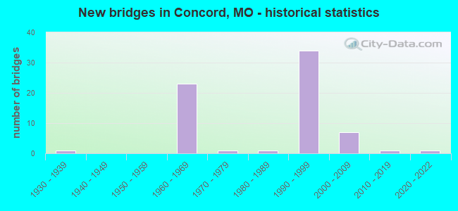
- New bridges - historical statistics
- 11930-1939
- 231960-1969
- 11970-1979
- 11980-1989
- 341990-1999
- 72000-2009
- 12010-2019
- 12020-2022
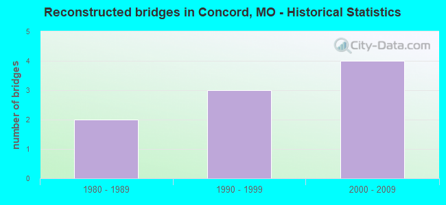
- Reconstructed bridges - Historical Statistics
- 21980-1989
- 31990-1999
- 42000-2009
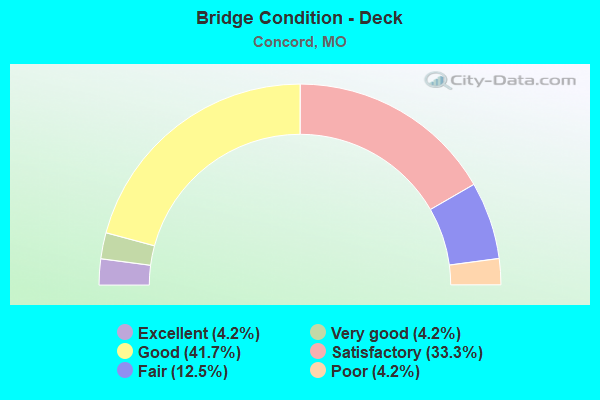
- Bridge Condition - Deck
- 4.2%Excellent
- 4.2%Very good
- 41.7%Good
- 33.3%Satisfactory
- 12.5%Fair
- 4.2%Poor
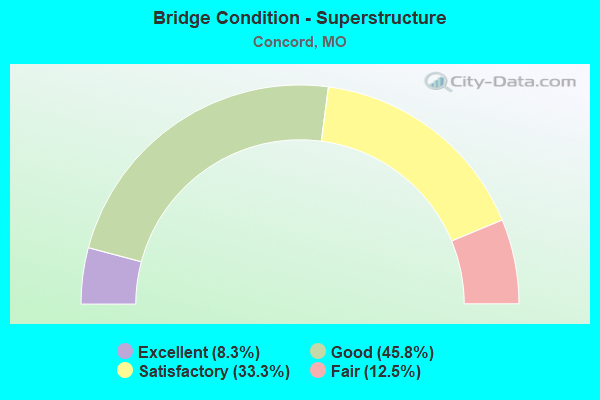
- Bridge Condition - Superstructure
- 8.3%Excellent
- 45.8%Good
- 33.3%Satisfactory
- 12.5%Fair
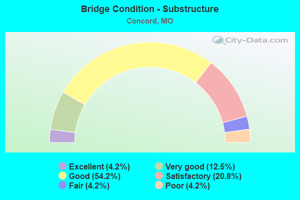
- Bridge Condition - Substructure
- 4.2%Excellent
- 12.5%Very good
- 54.2%Good
- 20.8%Satisfactory
- 4.2%Fair
- 4.2%Poor
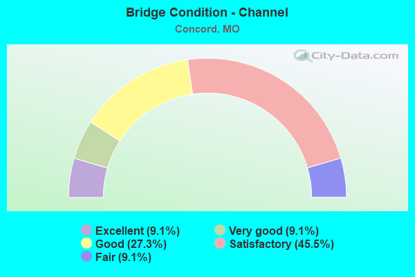
- Bridge Condition - Channel
- 9.1%Excellent
- 9.1%Very good
- 27.3%Good
- 45.5%Satisfactory
- 9.1%Fair
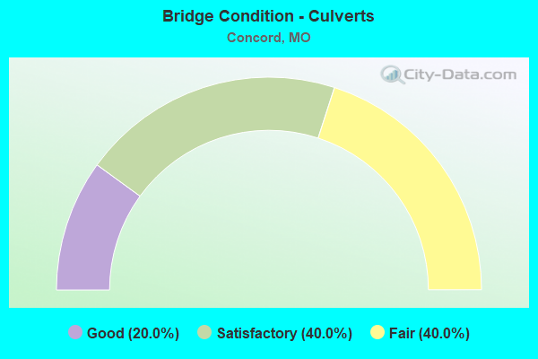
- Bridge Condition - Culverts
- 20.0%Good
- 40.0%Satisfactory
- 40.0%Fair
Find on map >> Show street view
Structure Number: 10086, Location: S 34 T 44 N R 6 E (Lat: 38.511025, Lng: -90.335150), Route carried "on" structure: US 50, Year Built: 1995, Status: Open, Structure Length: 1.71m (5.61ft), Average Daily Traffic: 30,131 (year 2021), Truck Traffic: 6%, Average Future Daily Traffic: 42,183 (year 2041), Design Load: HS 20+Mod, Features Intersected: RP IS255N TO IS55N
Minimum Vertical Clearance: 30+ m (98+ ft), Kilometerpoint: 415.443, Lanes on structure: 8, Lanes under structure: 2, Base Highway Network: Yes, Owner: State Highway Agency, Approaching Roadway Width: 25.0m (82.0ft), Skew: 31 degrees, Material/Design: Prestressed concrete continuous, Design/Construction: Stringer/Multi-beam, Number Of Spans In Main Unit: 1, Length of Maximum Span: 17.1m (56.1ft), Curb or Sidewalk Widths: Left: 0.2m (0.7ft), Right: 0.2m (0.7ft), Curb-To-Curb Width: 36.2m (118.8ft), Out-to-Out Width: 37.0m (121.4ft)
Condition: Deck: Satisfactory, Superstructure: Good, Substructure: Very good, Operating Rating: 84.6 metric tons, Method Used To Determine Operating Rating: Load Factor (LF), Inventory Rating: 50.4 metric tons, Method Used To Determine Inventory Rating: Load Factor (LF), Structural Evaluation: Better than present minimum criteria, Deck Geometry: Superior to present desirable criteria, Underclear: Equal to present minimum criteria, Approach Roadway Alignment: Equal to present desirable criteria, Designated Inspection Frequency: Every 24 months, Inspection Date: July 2020, Deck Structure Type: Concrete Cast-file-Place, Wearing Surface/Protective System: Wearing Surface: Monolithic Concrete, Deck Protection: Epoxy Coated Reinforcing
Find on map >> Show street view
Structure Number: 1015, Location: S 34 T 43 N R 6 E (Lat: 38.503192, Lng: -90.338703), Route carried "on" structure: Ramp State highway , Year Built: 1964, Year Reconstructed: 1991, Status: Open, Structure Length: 9.57m (31.40ft), Average Daily Traffic: 12,988 (year 2021), Truck Traffic: 18%, Average Future Daily Traffic: 16,235 (year 2041), Design Load: HS 20+Mod, Features Intersected: RP IS270W TO IS55N, IS 5, Facility Carried by Structure: RP IS270W TO IS55N
Minimum Vertical Clearance: 5.03m (16.50ft), Kilometerpoint: 1.078, Lanes on structure: 2, Lanes under structure: 11, Base Highway Network: Yes, Owner: State Highway Agency, Approaching Roadway Width: 12.2m (40.0ft), Skew: 1 degrees, Material/Design: Concrete continuous, Design/Construction: Box Beam or Girders - Single/Spread, Number Of Spans In Main Unit: 5, Length of Maximum Span: 24.4m (80.1ft), Curb or Sidewalk Widths: Left: 0.2m (0.7ft), Right: 0.2m (0.7ft), Curb-To-Curb Width: 11.4m (37.4ft), Out-to-Out Width: 12.3m (40.4ft)
Condition: Deck: Good, Superstructure: Satisfactory, Substructure: Good, Operating Rating: 51.3 metric tons, Method Used To Determine Operating Rating: Load Factor (LF), Inventory Rating: 30.6 metric tons, Method Used To Determine Inventory Rating: Load Factor (LF), Structural Evaluation: Equal to present minimum criteria, Deck Geometry: Equal to present minimum criteria, Underclear: Somewhat better than minimum adequacy, Approach Roadway Alignment: Equal to present desirable criteria, Designated Inspection Frequency: Every 24 months, Inspection Date: July 2020, Deck Structure Type: Concrete Cast-file-Place, Wearing Surface/Protective System: Wearing Surface: Other
Find on map >> Show street view
Structure Number: 15627, Location: S 22 T 44 N R 6 E (Lat: 38.534414, Lng: -90.342136), Route carried "on" structure: County highway , Year Built: 1933, Status: Posted for load, Structure Length: 2.93m (9.61ft), Average Daily Traffic: 3,450 (year 2020), Truck Traffic: 5%, Average Future Daily Traffic: 4,658 (year 2040), Features Intersected: GRAVOIS CR, Facility Carried by Structure: TESSHIRE DR
Minimum Vertical Clearance: 30+ m (98+ ft), Kilometerpoint: 0.016, Lanes on structure: 2, Owner: County Highway Agency, Approaching Roadway Width: 12.2m (40.0ft), Material/Design: Concrete, Design/Construction: Tee Beam, Number Of Spans In Main Unit: 3, Length of Maximum Span: 10.1m (33.1ft), Curb-To-Curb Width: 12.2m (40.0ft), Out-to-Out Width: 13.1m (43.0ft)
Condition: Deck: Fair, Superstructure: Fair, Substructure: Poor, Channel: Satisfactory, Operating Rating: 58.5 metric tons, Method Used To Determine Operating Rating: Allowable Stress (AS), Inventory Rating: 22.5 metric tons, Method Used To Determine Inventory Rating: Allowable Stress (AS), Structural Evaluation: Meets minimum limits, Deck Geometry: Equal to present minimum criteria, Waterway Adequacy: Better than present minimum criteria, Approach Roadway Alignment: Better than present minimum criteria, Length Of Structure Improvement: 0.38m (1.25ft), Designated Inspection Frequency: Every 24 months, Inspection Date: April 2021, Bridge Improvement Cost: $326,000, Roadway Improvement Cost: $33,000, Total Project Cost: $490,000 ( Estimate for 2022), Deck Structure Type: Concrete Cast-file-Place, Wearing Surface/Protective System: Wearing Surface: Bituminous
Find on map >> Show street view
Structure Number: 15655, Location: S 33 T 44 N R 6 E (Lat: 38.503714, Lng: -90.347339), Route carried "on" structure: County highway , Year Built: 1990, Status: Posted for load, Structure Length: 1.77m (5.81ft), Average Daily Traffic: 3,196 (year 2020), Truck Traffic: 3%, Average Future Daily Traffic: 4,315 (year 2040), Design Load: HS 20, Features Intersected: BR OF MATTESE CR, Facility Carried by Structure: VON TALGE RD
Minimum Vertical Clearance: 30+ m (98+ ft), Kilometerpoint: 0.418, Lanes on structure: 2, Owner: County Highway Agency, Approaching Roadway Width: 13.4m (44.0ft), Material/Design: Prestressed concrete, Design/Construction: Stringer/Multi-beam, Number Of Spans In Main Unit: 1, Length of Maximum Span: 17.1m (56.1ft), Curb-To-Curb Width: 13.4m (44.0ft), Out-to-Out Width: 17.9m (58.7ft)
Condition: Deck: Good, Superstructure: Satisfactory, Substructure: Good, Channel: Satisfactory, Operating Rating: 89.1 metric tons, Method Used To Determine Operating Rating: Allowable Stress (AS), Inventory Rating: 74.7 metric tons, Method Used To Determine Inventory Rating: Allowable Stress (AS), Structural Evaluation: Equal to present minimum criteria, Deck Geometry: Better than present minimum criteria, Waterway Adequacy: Equal to present desirable criteria, Approach Roadway Alignment: Equal to present minimum criteria, Designated Inspection Frequency: Every 24 months, Inspection Date: March 2020, Deck Structure Type: Concrete Cast-file-Place, Wearing Surface/Protective System: Wearing Surface: Monolithic Concrete, Membrane: Epoxy, Deck Protection: Epoxy Coated Reinforcing
Find on map >> Show street view
Structure Number: 15706, Location: S 8 T 43 N R 6 E (Lat: 38.475583, Lng: -90.378067), Route carried "on" structure: County highway , Year Built: 1976, Status: Posted for load, Structure Length: 0.67m (2.20ft), Average Daily Traffic: 861 (year 2020), Truck Traffic: 2%, Average Future Daily Traffic: 1,162 (year 2040), Design Load: HS 20, Features Intersected: LEMAY CR, Facility Carried by Structure: MELISSA-JO LN
Minimum Vertical Clearance: 30+ m (98+ ft), Kilometerpoint: 5.472, Lanes on structure: 2, Owner: County Highway Agency, Approaching Roadway Width: 7.9m (25.9ft), Material/Design: Concrete, Design/Construction: Culvert, Number Of Spans In Main Unit: 2, Length of Maximum Span: 3.3m (10.8ft)
Condition: Channel: Satisfactory, Culverts: Satisfactory, Operating Rating: 56.7 metric tons, Method Used To Determine Operating Rating: Allowable Stress (AS), Inventory Rating: 25.2 metric tons, Method Used To Determine Inventory Rating: Allowable Stress (AS), Structural Evaluation: Equal to present minimum criteria, Waterway Adequacy: Better than present minimum criteria, Approach Roadway Alignment: Equal to present desirable criteria, Designated Inspection Frequency: Every 24 months, Inspection Date: March 2020
Find on map >> Show street view
Structure Number: 29668, Location: S 34 T 44 N R 6 E (Lat: 38.502614, Lng: -90.330344), Route carried "on" structure: US 61, Year Built: 2004, Status: Open, Structure Length: 11.61m (38.09ft), Average Daily Traffic: 22,413 (year 2021), Truck Traffic: 3%, Average Future Daily Traffic: 31,378 (year 2041), Design Load: HS 20, Features Intersected: IS 255
Minimum Vertical Clearance: 30+ m (98+ ft), Kilometerpoint: 283.900, Lanes on structure: 6, Lanes under structure: 10, Base Highway Network: Yes, Owner: State Highway Agency, Approaching Roadway Width: 26.4m (86.6ft), Skew: 24 degrees, Material/Design: Steel continuous, Design/Construction: Stringer/Multi-beam, Number Of Spans In Main Unit: 4, Length of Maximum Span: 32.6m (107.0ft), Curb or Sidewalk Widths: Left: 0.4m (1.3ft), Right: 2.2m (7.2ft), Curb-To-Curb Width: 27.1m (88.9ft), Out-to-Out Width: 29.7m (97.4ft)
Condition: Deck: Good, Superstructure: Good, Substructure: Satisfactory, Operating Rating: 75.6 metric tons, Method Used To Determine Operating Rating: Load Factor (LF), Inventory Rating: 45.0 metric tons, Method Used To Determine Inventory Rating: Load Factor (LF), Structural Evaluation: Equal to present minimum criteria, Deck Geometry: Better than present minimum criteria, Underclear: Meets minimum limits, Approach Roadway Alignment: Equal to present desirable criteria, Designated Inspection Frequency: Every 24 months, Inspection Date: July 2020, Deck Structure Type: Concrete Cast-file-Place, Wearing Surface/Protective System: Wearing Surface: Epoxy Overlay, Deck Protection: Epoxy Coated Reinforcing
Find on map >> Show street view
Structure Number: 32407, Location: S 32 T 44 N R 6 E (Lat: 38.508569, Lng: -90.362628), Route carried "on" structure: County highway 141, Year Built: 2008, Status: Posted for load, Structure Length: 0.98m (3.22ft), Average Daily Traffic: 457 (year 2020), Truck Traffic: 2%, Average Future Daily Traffic: 617 (year 2040), Design Load: HS 20, Features Intersected: MATTESE CR, Facility Carried by Structure: DUBOURG LN
Minimum Vertical Clearance: 30+ m (98+ ft), Kilometerpoint: 3.862, Lanes on structure: 2, Owner: County Highway Agency, Approaching Roadway Width: 6.1m (20.0ft), Skew: 2 degrees, Material/Design: Concrete, Design/Construction: Culvert, Number Of Spans In Main Unit: 1, Length of Maximum Span: 9.4m (30.8ft)
Condition: Channel: Good, Culverts: Good, Operating Rating: 80.1 metric tons, Method Used To Determine Operating Rating: Load Factor (LF), Inventory Rating: 47.7 metric tons, Method Used To Determine Inventory Rating: Load Factor (LF), Structural Evaluation: Better than present minimum criteria, Waterway Adequacy: Superior to present desirable criteria, Approach Roadway Alignment: Equal to present desirable criteria, Designated Inspection Frequency: Every 24 months, Inspection Date: March 2020
Find on map >> Show street view
Structure Number: 3275, Location: S 5 T 26 N R 1 W (Lat: 36.951322, Lng: -91.083550), Route carried "on" structure: US 60, Year Built: 1983, Year Reconstructed: 2005, Status: Open, Structure Length: 1.23m (4.04ft), Average Daily Traffic: 3,883 (year 2021), Truck Traffic: 45%, Average Future Daily Traffic: 7,378 (year 2041), Design Load: HS 20+Mod, Features Intersected: POCA HOLLOW
Minimum Vertical Clearance: 30+ m (98+ ft), Kilometerpoint: 353.932, Lanes on structure: 4, Base Highway Network: Yes, Owner: State Highway Agency, Approaching Roadway Width: 8.5m (27.9ft), Material/Design: Concrete continuous, Design/Construction: Culvert, Number Of Spans In Main Unit: 3, Length of Maximum Span: 4.0m (13.1ft)
Condition: Channel: Good, Culverts: Satisfactory, Inventory Rating: 78.3 metric tons, Method Used To Determine Inventory Rating: Load Factor (LF), Structural Evaluation: Equal to present minimum criteria, Waterway Adequacy: Equal to present desirable criteria, Approach Roadway Alignment: Equal to present desirable criteria, Designated Inspection Frequency: Every 24 months, Inspection Date: December 2021
Find on map >> Show street view
Structure Number: 3275, Location: S 24 T 44 N R 6 E (Lat: 38.540956, Lng: -90.302778), Route carried "on" structure: County highway , Year Built: 2009, Status: Open, Structure Length: 8.67m (28.44ft), Average Daily Traffic: 22,314 (year 2021), Truck Traffic: 5%, Average Future Daily Traffic: 31,240 (year 2041), Design Load: HS 20+Mod, Features Intersected: IS 55, Facility Carried by Structure: UNION RD E
Minimum Vertical Clearance: 30+ m (98+ ft), Kilometerpoint: 0.109, Lanes on structure: 4, Lanes under structure: 8, Owner: State Highway Agency, Approaching Roadway Width: 20.9m (68.6ft), Skew: 4 degrees, Material/Design: Steel continuous, Design/Construction: Stringer/Multi-beam, Number Of Spans In Main Unit: 2, Length of Maximum Span: 46.0m (150.9ft), Curb or Sidewalk Widths: Left: 1.6m (5.2ft), Right: 0.0m, Curb-To-Curb Width: 18.3m (60.0ft), Out-to-Out Width: 20.9m (68.6ft)
Condition: Deck: Good, Superstructure: Good, Substructure: Good, Operating Rating: 61.2 metric tons, Method Used To Determine Operating Rating: Load Factor (LF), Inventory Rating: 36.9 metric tons, Method Used To Determine Inventory Rating: Load Factor (LF), Structural Evaluation: Better than present minimum criteria, Deck Geometry: Somewhat better than minimum adequacy, Underclear: High priority of corrective action, Approach Roadway Alignment: Equal to present minimum criteria, Designated Inspection Frequency: Every 24 months, Inspection Date: July 2020, Deck Structure Type: Concrete Cast-file-Place, Wearing Surface/Protective System: Wearing Surface: Monolithic Concrete, Deck Protection: Epoxy Coated Reinforcing
Find on map >> Show street view
Structure Number: 35358, Location: S 21 T 44 N R 6 E (Lat: 38.535667, Lng: -90.351153), Route carried "on" structure: County highway , Year Built: 2017, Status: Open, Structure Length: 1.97m (6.46ft), Average Daily Traffic: 5,067 (year 2020), Truck Traffic: 5%, Average Future Daily Traffic: 6,840 (year 2040), Design Load: HS 20, Features Intersected: SAPPINGTON CR, Facility Carried by Structure: MUSICK AVE
Minimum Vertical Clearance: 30+ m (98+ ft), Kilometerpoint: 0.000, Lanes on structure: 2, Owner: County Highway Agency, Approaching Roadway Width: 9.8m (32.2ft), Skew: 3 degrees, Material/Design: Prestressed concrete, Design/Construction: Tee Beam, Number Of Spans In Main Unit: 1, Length of Maximum Span: 18.4m (60.4ft), Curb or Sidewalk Widths: Left: 1.7m (5.6ft), Right: 0.0m, Curb-To-Curb Width: 9.8m (32.2ft), Out-to-Out Width: 12.4m (40.7ft)
Condition: Deck: Very good, Superstructure: Excellent, Substructure: Very good, Channel: Good, Operating Rating: 58.5 metric tons, Method Used To Determine Operating Rating: Load Factor (LF), Inventory Rating: 45.0 metric tons, Method Used To Determine Inventory Rating: Load Factor (LF), Structural Evaluation: Equal to present desirable criteria, Deck Geometry: Meets minimum limits, Waterway Adequacy: Better than present minimum criteria, Approach Roadway Alignment: Equal to present desirable criteria, Designated Inspection Frequency: Every 24 months, Inspection Date: March 2020, Deck Structure Type: Concrete Cast-file-Place, Wearing Surface/Protective System: Wearing Surface: Monolithic Concrete, Deck Protection: Epoxy Coated Reinforcing
Find on map >> Show street view
Structure Number: 36119, Location: S 22 T 44 N R 6 E (Lat: 38.534408, Lng: -90.342083), Route carried "on" structure: County highway , Year Built: 2020, Status: Not yet open, Structure Length: 4.08m (13.39ft), Average Daily Traffic: 3,450 (year 2020), Truck Traffic: 5%, Average Future Daily Traffic: 4,658 (year 2040), Features Intersected: GRAVOIS CR, Facility Carried by Structure: TESSHIRE DR
Minimum Vertical Clearance: 30+ m (98+ ft), Kilometerpoint: 0.000, Lanes on structure: 2, Owner: County Highway Agency, Approaching Roadway Width: 8.5m (27.9ft), Skew: 2 degrees, Material/Design: Prestressed concrete, Design/Construction: Tee Beam, Number Of Spans In Main Unit: 2, Length of Maximum Span: 19.8m (65.0ft), Curb or Sidewalk Widths: Left: 3.6m (11.8ft), Right: 0.0m, Curb-To-Curb Width: 8.5m (27.9ft), Out-to-Out Width: 13.2m (43.3ft)
Condition: Deck: Excellent, Superstructure: Excellent, Substructure: Excellent, Channel: Excellent, Operating Rating: 60.3 metric tons, Method Used To Determine Operating Rating: Load and Resistance Factor (LRFR), Inventory Rating: 45.9 metric tons, Method Used To Determine Inventory Rating: Load and Resistance Factor (LRFR), Structural Evaluation: Superior to present desirable criteria, Deck Geometry: Meets minimum limits, Waterway Adequacy: Equal to present desirable criteria, Approach Roadway Alignment: Equal to present desirable criteria, Designated Inspection Frequency: Every 24 months, Inspection Date: August 2019, Deck Structure Type: Concrete Cast-file-Place, Wearing Surface/Protective System: Wearing Surface: Monolithic Concrete, Deck Protection: Epoxy Coated Reinforcing
Find on map >> Show street view
Structure Number: 365, Location: S 23 T 44 N R 7 E (Lat: 38.532928, Lng: -90.311592), Route carried "on" structure: Interstate 55, Year Built: 1962, Year Reconstructed: 2005, Status: Posted for load, Structure Length: 5.52m (18.11ft), Average Daily Traffic: 116,558 (year 2021), Truck Traffic: 18%, Average Future Daily Traffic: 145,698 (year 2041), Design Load: HS 20+Mod, Features Intersected: CRD REAVIS BARRACKS RD
Minimum Vertical Clearance: 30+ m (98+ ft), Kilometerpoint: 16.430, Lanes on structure: 8, Lanes under structure: 6, Base Highway Network: Yes, Owner: State Highway Agency, Approaching Roadway Width: 39.0m (128.0ft), Material/Design: Concrete continuous, Design/Construction: Slab, Number Of Spans In Main Unit: 4, Length of Maximum Span: 15.5m (50.9ft), Curb or Sidewalk Widths: Left: 0.2m (0.7ft), Right: 0.2m (0.7ft), Curb-To-Curb Width: 38.6m (126.6ft), Out-to-Out Width: 39.5m (129.6ft)
Condition: Deck: Satisfactory, Superstructure: Satisfactory, Substructure: Satisfactory, Operating Rating: 43.2 metric tons, Method Used To Determine Operating Rating: Load Factor (LF), Inventory Rating: 26.1 metric tons, Method Used To Determine Inventory Rating: Load Factor (LF), Structural Evaluation: Equal to present minimum criteria, Deck Geometry: Superior to present desirable criteria, Underclear: Meets minimum limits, Approach Roadway Alignment: Equal to present desirable criteria, Designated Inspection Frequency: Every 24 months, Inspection Date: July 2020, Deck Structure Type: Concrete Cast-file-Place, Wearing Surface/Protective System: Wearing Surface: Latex Concrete
Find on map >> Show street view
Structure Number: 3884, Location: S 1988 T 44 N R 6 E (Lat: 38.508358, Lng: -90.353803), Route carried "on" structure: County highway , Year Built: 1993, Status: Open, Structure Length: 8.14m (26.71ft), Average Daily Traffic: 1,207 (year 2021), Truck Traffic: 5%, Average Future Daily Traffic: 1,811 (year 2041), Design Load: HS 20+Mod, Features Intersected: IS 270, Facility Carried by Structure: THEISS RD S
Minimum Vertical Clearance: 30+ m (98+ ft), Kilometerpoint: 1.049, Lanes on structure: 2, Lanes under structure: 12, Owner: State Highway Agency, Approaching Roadway Width: 8.5m (27.9ft), Material/Design: Steel continuous, Design/Construction: Stringer/Multi-beam, Number Of Spans In Main Unit: 2, Length of Maximum Span: 35.4m (116.1ft), Curb or Sidewalk Widths: Left: 0.2m (0.7ft), Right: 0.2m (0.7ft), Curb-To-Curb Width: 11.8m (38.7ft), Out-to-Out Width: 12.6m (41.3ft)
Condition: Deck: Good, Superstructure: Good, Substructure: Good, Operating Rating: 67.5 metric tons, Method Used To Determine Operating Rating: Load Factor (LF), Inventory Rating: 40.5 metric tons, Method Used To Determine Inventory Rating: Load Factor (LF), Structural Evaluation: Better than present minimum criteria, Deck Geometry: Equal to present minimum criteria, Underclear: Meets minimum limits, Approach Roadway Alignment: Equal to present desirable criteria, Designated Inspection Frequency: Every 24 months, Inspection Date: July 2020, Deck Structure Type: Concrete Cast-file-Place, Wearing Surface/Protective System: Wearing Surface: Epoxy Overlay, Deck Protection: Epoxy Coated Reinforcing
Find on map >> Show street view
Structure Number: 397, Location: S 33 T 44 N R 6 E (Lat: 38.505047, Lng: -90.344144), Route carried "on" structure: Ramp State highway , Year Built: 1993, Status: Open, Structure Length: 9.14m (29.99ft), Average Daily Traffic: 23,373 (year 2021), Truck Traffic: 18%, Average Future Daily Traffic: 29,216 (year 2041), Design Load: HS 20+Mod, Features Intersected: CRD VON TALGE RD, BNSF R, Facility Carried by Structure: RP IS270W TO IS55N
Minimum Vertical Clearance: 30+ m (98+ ft), Kilometerpoint: 0.570, Lanes on structure: 3, Lanes under structure: 2, Base Highway Network: Yes, Owner: State Highway Agency, Approaching Roadway Width: 12.2m (40.0ft), Skew: 2 degrees, Material/Design: Steel continuous, Design/Construction: Stringer/Multi-beam, Number Of Spans In Main Unit: 4, Length of Maximum Span: 27.7m (90.9ft), Curb or Sidewalk Widths: Left: 0.2m (0.7ft), Right: 0.2m (0.7ft), Curb-To-Curb Width: 15.5m (50.9ft), Out-to-Out Width: 16.3m (53.5ft)
Condition: Deck: Satisfactory, Superstructure: Good, Substructure: Satisfactory, Operating Rating: 57.6 metric tons, Method Used To Determine Operating Rating: Load Factor (LF), Inventory Rating: 34.2 metric tons, Method Used To Determine Inventory Rating: Load Factor (LF), Structural Evaluation: Equal to present minimum criteria, Deck Geometry: Superior to present desirable criteria, Underclear: Somewhat better than minimum adequacy, Approach Roadway Alignment: Equal to present desirable criteria, Designated Inspection Frequency: Every 24 months, Inspection Date: July 2020, Deck Structure Type: Concrete Cast-file-Place, Wearing Surface/Protective System: Wearing Surface: Monolithic Concrete, Deck Protection: Epoxy Coated Reinforcing
Find on map >> Show street view
Structure Number: 3971, Location: S 33 T 44 N R 6 E (Lat: 38.505428, Lng: -90.343639), Route carried "on" structure: Ramp State highway , Year Built: 1993, Status: Open, Structure Length: 8.53m (27.99ft), Average Daily Traffic: 24,433 (year 2021), Truck Traffic: 19%, Average Future Daily Traffic: 30,541 (year 2041), Design Load: HS 20+Mod, Features Intersected: CRD VON TALGE RD, BNSF R, Facility Carried by Structure: RP IS55N TO IS270E
Minimum Vertical Clearance: 30+ m (98+ ft), Kilometerpoint: 1.017, Lanes on structure: 3, Lanes under structure: 2, Base Highway Network: Yes, Owner: State Highway Agency, Approaching Roadway Width: 12.2m (40.0ft), Skew: 31 degrees, Material/Design: Steel continuous, Design/Construction: Stringer/Multi-beam, Number Of Spans In Main Unit: 4, Length of Maximum Span: 26.5m (86.9ft), Curb or Sidewalk Widths: Left: 0.2m (0.7ft), Right: 0.2m (0.7ft), Curb-To-Curb Width: 15.5m (50.9ft), Out-to-Out Width: 16.3m (53.5ft)
Condition: Deck: Good, Superstructure: Good, Substructure: Good, Operating Rating: 65.7 metric tons, Method Used To Determine Operating Rating: Load Factor (LF), Inventory Rating: 39.6 metric tons, Method Used To Determine Inventory Rating: Load Factor (LF), Structural Evaluation: Better than present minimum criteria, Deck Geometry: Superior to present desirable criteria, Underclear: Better than present minimum criteria, Approach Roadway Alignment: Equal to present desirable criteria, Designated Inspection Frequency: Every 24 months, Inspection Date: July 2020, Deck Structure Type: Concrete Cast-file-Place, Wearing Surface/Protective System: Wearing Surface: Monolithic Concrete, Deck Protection: Epoxy Coated Reinforcing
Find on map >> Show street view
Structure Number: 3974, Location: S 34 T 44 N R 6 E (Lat: 38.503142, Lng: -90.339017), Route carried "on" structure: Ramp State highway , Year Built: 1991, Status: Open, Structure Length: 40.66m (133.40ft), Average Daily Traffic: 24,433 (year 2021), Truck Traffic: 19%, Average Future Daily Traffic: 30,541 (year 2041), Design Load: HS 20+Mod, Features Intersected: IS 55, IS 255, RP IS270W, Facility Carried by Structure: RP IS55N TO IS270E
Minimum Vertical Clearance: 30+ m (98+ ft), Kilometerpoint: 0.338, Lanes on structure: 2, Lanes under structure: 22, Base Highway Network: Yes, Owner: State Highway Agency, Approaching Roadway Width: 12.2m (40.0ft), Skew: 4 degrees, Material/Design: Steel continuous, Design/Construction: Stringer/Multi-beam, Number Of Spans In Main Unit: 14, Length of Maximum Span: 50.6m (166.0ft), Curb or Sidewalk Widths: Left: 0.2m (0.7ft), Right: 0.2m (0.7ft), Curb-To-Curb Width: 11.8m (38.7ft), Out-to-Out Width: 12.6m (41.3ft)
Condition: Deck: Good, Superstructure: Good, Substructure: Good, Operating Rating: 62.1 metric tons, Method Used To Determine Operating Rating: Load Factor (LF), Inventory Rating: 37.8 metric tons, Method Used To Determine Inventory Rating: Load Factor (LF), Structural Evaluation: Better than present minimum criteria, Deck Geometry: Superior to present desirable criteria, Underclear: Meets minimum limits, Approach Roadway Alignment: Equal to present desirable criteria, Designated Inspection Frequency: Every 24 months, Inspection Date: March 2021, Deck Structure Type: Concrete Cast-file-Place, Wearing Surface/Protective System: Wearing Surface: Monolithic Concrete, Deck Protection: Epoxy Coated Reinforcing
Find on map >> Show street view
Structure Number: 3975, Location: S 34 T 44 N R 6 E (Lat: 38.503317, Lng: -90.339017), Route carried "on" structure: Ramp State highway , Year Built: 1991, Status: Open, Structure Length: 41.03m (134.61ft), Average Daily Traffic: 12,359 (year 2021), Truck Traffic: 19%, Average Future Daily Traffic: 15,449 (year 2041), Design Load: HS 20+Mod, Features Intersected: RP IS270E TO IS55S, RP I, Facility Carried by Structure: RP IS55S TO IS255S
Minimum Vertical Clearance: 30+ m (98+ ft), Kilometerpoint: 1.323, Lanes on structure: 2, Lanes under structure: 19, Base Highway Network: Yes, Owner: State Highway Agency, Approaching Roadway Width: 12.2m (40.0ft), Skew: 2 degrees, Material/Design: Steel continuous, Design/Construction: Stringer/Multi-beam, Number Of Spans In Main Unit: 16, Length of Maximum Span: 27.5m (90.2ft), Curb or Sidewalk Widths: Left: 0.2m (0.7ft), Right: 0.2m (0.7ft), Curb-To-Curb Width: 11.8m (38.7ft), Out-to-Out Width: 12.6m (41.3ft)
Condition: Deck: Satisfactory, Superstructure: Satisfactory, Substructure: Good, Operating Rating: 84.6 metric tons, Method Used To Determine Operating Rating: Load Factor (LF), Inventory Rating: 51.3 metric tons, Method Used To Determine Inventory Rating: Load Factor (LF), Structural Evaluation: Equal to present minimum criteria, Deck Geometry: Superior to present desirable criteria, Underclear: High priority of corrective action, Approach Roadway Alignment: Equal to present desirable criteria, Designated Inspection Frequency: Every 24 months, Inspection Date: March 2021, Deck Structure Type: Concrete Cast-file-Place, Wearing Surface/Protective System: Wearing Surface: Monolithic Concrete, Deck Protection: Epoxy Coated Reinforcing
Find on map >> Show street view
Structure Number: 3996, Location: S 4 T 43 N R 6 E (Lat: 38.495414, Lng: -90.346742), Route carried "on" structure: County highway , Year Built: 1995, Status: Open, Structure Length: 8.17m (26.80ft), Average Daily Traffic: 1,526 (year 2021), Truck Traffic: 5%, Average Future Daily Traffic: 2,136 (year 2041), Design Load: HS 20, Features Intersected: IS 55, Facility Carried by Structure: MATTIS RD E
Minimum Vertical Clearance: 30+ m (98+ ft), Kilometerpoint: 3.009, Lanes on structure: 2, Lanes under structure: 12, Owner: State Highway Agency, Approaching Roadway Width: 13.1m (43.0ft), Skew: 11 degrees, Material/Design: Steel continuous, Design/Construction: Stringer/Multi-beam, Number Of Spans In Main Unit: 2, Length of Maximum Span: 42.2m (138.5ft), Curb or Sidewalk Widths: Left: 0.2m (0.7ft), Right: 0.2m (0.7ft), Curb-To-Curb Width: 13.0m (42.7ft), Out-to-Out Width: 13.9m (45.6ft)
Condition: Deck: Good, Superstructure: Good, Substructure: Good, Operating Rating: 63.0 metric tons, Method Used To Determine Operating Rating: Load Factor (LF), Inventory Rating: 37.8 metric tons, Method Used To Determine Inventory Rating: Load Factor (LF), Structural Evaluation: Better than present minimum criteria, Deck Geometry: Better than present minimum criteria, Underclear: Meets minimum limits, Approach Roadway Alignment: Equal to present minimum criteria, Designated Inspection Frequency: Every 24 months, Inspection Date: July 2020, Deck Structure Type: Concrete Cast-file-Place, Wearing Surface/Protective System: Wearing Surface: Monolithic Concrete, Deck Protection: Epoxy Coated Reinforcing
Find on map >> Show street view
Structure Number: 4124, Location: S 34 T 44 N R 6 E (Lat: 38.511686, Lng: -90.336542), Route carried "on" structure: US 50, Year Built: 1995, Status: Open, Structure Length: 1.74m (5.71ft), Average Daily Traffic: 43,006 (year 2021), Truck Traffic: 6%, Average Future Daily Traffic: 60,208 (year 2041), Design Load: HS 20+Mod, Features Intersected: RP IS55S TO IS255S
Minimum Vertical Clearance: 30+ m (98+ ft), Kilometerpoint: 415.302, Lanes on structure: 8, Lanes under structure: 1, Base Highway Network: Yes, Owner: State Highway Agency, Approaching Roadway Width: 36.0m (118.1ft), Skew: 32 degrees, Material/Design: Prestressed concrete continuous, Design/Construction: Stringer/Multi-beam, Number Of Spans In Main Unit: 1, Length of Maximum Span: 13.8m (45.3ft), Curb or Sidewalk Widths: Left: 0.2m (0.7ft), Right: 0.2m (0.7ft), Curb-To-Curb Width: 36.2m (118.8ft), Out-to-Out Width: 37.0m (121.4ft)
Condition: Deck: Satisfactory, Superstructure: Good, Substructure: Good, Operating Rating: 75.6 metric tons, Method Used To Determine Operating Rating: Load Factor (LF), Inventory Rating: 45.0 metric tons, Method Used To Determine Inventory Rating: Load Factor (LF), Structural Evaluation: Better than present minimum criteria, Deck Geometry: Superior to present desirable criteria, Underclear: Equal to present minimum criteria, Approach Roadway Alignment: Equal to present desirable criteria, Designated Inspection Frequency: Every 24 months, Inspection Date: July 2020, Deck Structure Type: Concrete Cast-file-Place, Wearing Surface/Protective System: Wearing Surface: Monolithic Concrete, Deck Protection: Epoxy Coated Reinforcing
Find on map >> Show street view
Structure Number: 4125, Location: S 34 T 44 N R 6 E (Lat: 38.511361, Lng: -90.335867), Route carried "on" structure: US 50, Year Built: 1995, Status: Open, Structure Length: 4.36m (14.30ft), Average Daily Traffic: 29,671 (year 2021), Truck Traffic: 6%, Average Future Daily Traffic: 41,539 (year 2041), Design Load: HS 20+Mod, Features Intersected: IS 55
Minimum Vertical Clearance: 30+ m (98+ ft), Kilometerpoint: 415.356, Lanes on structure: 7, Lanes under structure: 7, Base Highway Network: Yes, Owner: State Highway Agency, Approaching Roadway Width: 60.7m (199.1ft), Skew: 31 degrees, Material/Design: Prestressed concrete continuous, Design/Construction: Stringer/Multi-beam, Number Of Spans In Main Unit: 2, Length of Maximum Span: 21.8m (71.5ft), Curb or Sidewalk Widths: Left: 0.2m (0.7ft), Right: 0.2m (0.7ft), Curb-To-Curb Width: 76.1m (249.7ft), Out-to-Out Width: 76.5m (251.0ft)
Condition: Deck: Satisfactory, Superstructure: Satisfactory, Substructure: Good, Operating Rating: 70.2 metric tons, Method Used To Determine Operating Rating: Load Factor (LF), Inventory Rating: 38.7 metric tons, Method Used To Determine Inventory Rating: Load Factor (LF), Structural Evaluation: Equal to present minimum criteria, Deck Geometry: Superior to present desirable criteria, Underclear: Meets minimum limits, Approach Roadway Alignment: Equal to present desirable criteria, Designated Inspection Frequency: Every 24 months, Inspection Date: July 2020, Deck Structure Type: Concrete Cast-file-Place, Wearing Surface/Protective System: Wearing Surface: Monolithic Concrete, Deck Protection: Epoxy Coated Reinforcing
Find on map >> Show street view
Structure Number: 419, Location: S 26 T 44 N R 6 E (Lat: 38.524708, Lng: -90.319728), Route carried "on" structure: Interstate 55, Year Built: 1962, Year Reconstructed: 2005, Status: Open, Structure Length: 7.41m (24.31ft), Average Daily Traffic: 55,851 (year 2021), Truck Traffic: 18%, Average Future Daily Traffic: 69,814 (year 2041), Design Load: HS 20+Mod, Features Intersected: CST GREEN PARK RD
Minimum Vertical Clearance: 30+ m (98+ ft), Kilometerpoint: 17.576, Lanes on structure: 4, Lanes under structure: 2, Base Highway Network: Yes, Owner: State Highway Agency, Approaching Roadway Width: 19.5m (64.0ft), Skew: 2 degrees, Material/Design: Steel continuous, Design/Construction: Stringer/Multi-beam, Number Of Spans In Main Unit: 4, Length of Maximum Span: 20.4m (66.9ft), Curb or Sidewalk Widths: Left: 0.2m (0.7ft), Right: 0.2m (0.7ft), Curb-To-Curb Width: 18.9m (62.0ft), Out-to-Out Width: 19.6m (64.3ft)
Condition: Deck: Fair, Superstructure: Fair, Substructure: Fair, Operating Rating: 60.3 metric tons, Method Used To Determine Operating Rating: Load Factor (LF), Inventory Rating: 36.0 metric tons, Method Used To Determine Inventory Rating: Load Factor (LF), Structural Evaluation: Somewhat better than minimum adequacy, Deck Geometry: Meets minimum limits, Underclear: Somewhat better than minimum adequacy, Approach Roadway Alignment: Equal to present desirable criteria, Designated Inspection Frequency: Every 24 months, Inspection Date: July 2020, Deck Structure Type: Concrete Cast-file-Place, Wearing Surface/Protective System: Wearing Surface: Low Slump Concrete, Membrane: Built-up
Find on map >> Show street view
Structure Number: 42, Location: S 21 T 49 N R 31 W (Lat: 39.040161, Lng: -94.349653), Route carried "on" structure: Interstate 70, Year Built: 1964, Year Reconstructed: 2004, Status: Posted for load, Structure Length: 6.64m (21.78ft), Average Daily Traffic: 53,837 (year 2021), Truck Traffic: 24%, Average Future Daily Traffic: 72,680 (year 2041), Design Load: HS 20+Mod, Features Intersected: LIT BLUE RVR
Minimum Vertical Clearance: 30+ m (98+ ft), Kilometerpoint: 376.294, Lanes on structure: 4, Base Highway Network: Yes, Owner: State Highway Agency, Approaching Roadway Width: 16.5m (54.1ft), Skew: 2 degrees, Material/Design: Steel continuous, Design/Construction: Stringer/Multi-beam, Number Of Spans In Main Unit: 3, Length of Maximum Span: 24.4m (80.1ft), Curb or Sidewalk Widths: Left: 0.2m (0.7ft), Right: 0.2m (0.7ft), Curb-To-Curb Width: 15.8m (51.8ft), Out-to-Out Width: 16.6m (54.5ft)
Condition: Deck: Good, Superstructure: Good, Substructure: Good, Channel: Very good, Operating Rating: 53.1 metric tons, Method Used To Determine Operating Rating: Load Factor (LF), Inventory Rating: 31.5 metric tons, Method Used To Determine Inventory Rating: Load Factor (LF), Structural Evaluation: Better than present minimum criteria, Deck Geometry: Meets minimum limits, Waterway Adequacy: Equal to present desirable criteria, Approach Roadway Alignment: Equal to present desirable criteria, Designated Inspection Frequency: Every 24 months, Inspection Date: October 2021, Deck Structure Type: Concrete Cast-file-Place, Wearing Surface/Protective System: Wearing Surface: Monolithic Concrete
Find on map >> Show street view
Structure Number: 42, Location: S 26 T 44 N R 6 E (Lat: 38.524567, Lng: -90.319639), Route carried "on" structure: Interstate 55, Year Built: 1962, Year Reconstructed: 2005, Status: Open, Structure Length: 7.41m (24.31ft), Average Daily Traffic: 52,583 (year 2021), Truck Traffic: 12%, Average Future Daily Traffic: 65,729 (year 2041), Design Load: HS 20+Mod, Features Intersected: CST GREEN PARK RD
Minimum Vertical Clearance: 30+ m (98+ ft), Kilometerpoint: 319.990, Lanes on structure: 4, Lanes under structure: 2, Base Highway Network: Yes, Owner: State Highway Agency, Approaching Roadway Width: 19.5m (64.0ft), Skew: 2 degrees, Material/Design: Steel continuous, Design/Construction: Stringer/Multi-beam, Number Of Spans In Main Unit: 4, Length of Maximum Span: 20.4m (66.9ft), Curb or Sidewalk Widths: Left: 0.2m (0.7ft), Right: 0.2m (0.7ft), Curb-To-Curb Width: 18.9m (62.0ft), Out-to-Out Width: 19.6m (64.3ft)
Condition: Deck: Fair, Superstructure: Satisfactory, Substructure: Satisfactory, Operating Rating: 60.3 metric tons, Method Used To Determine Operating Rating: Load Factor (LF), Inventory Rating: 36.0 metric tons, Method Used To Determine Inventory Rating: Load Factor (LF), Structural Evaluation: Equal to present minimum criteria, Deck Geometry: Meets minimum limits, Underclear: Somewhat better than minimum adequacy, Approach Roadway Alignment: Equal to present desirable criteria, Designated Inspection Frequency: Every 24 months, Inspection Date: July 2020, Deck Structure Type: Concrete Cast-file-Place, Wearing Surface/Protective System: Wearing Surface: Low Slump Concrete
Find on map >> Show street view
Structure Number: 4341, Location: S 4 T 43 N R 6 E (Lat: 38.485661, Lng: -90.355483), Route carried "on" structure: Interstate 55, Year Built: 1995, Status: Open, Structure Length: 8.23m (27.00ft), Average Daily Traffic: 60,994 (year 2021), Truck Traffic: 18%, Average Future Daily Traffic: 76,243 (year 2041), Design Load: HS 25 or greater, Features Intersected: BUTLER HILL RD, BUTLER H
Minimum Vertical Clearance: 30+ m (98+ ft), Kilometerpoint: 314.436, Lanes on structure: 5, Lanes under structure: 7, Base Highway Network: Yes, Owner: State Highway Agency, Approaching Roadway Width: 25.6m (84.0ft), Skew: 3 degrees, Material/Design: Prestressed concrete continuous, Design/Construction: Stringer/Multi-beam, Number Of Spans In Main Unit: 4, Length of Maximum Span: 25.9m (85.0ft), Curb or Sidewalk Widths: Left: 0.2m (0.7ft), Right: 0.2m (0.7ft), Curb-To-Curb Width: 25.1m (82.3ft), Out-to-Out Width: 26.0m (85.3ft)
Condition: Deck: Satisfactory, Superstructure: Fair, Substructure: Good, Operating Rating: 89.1 metric tons, Method Used To Determine Operating Rating: Load Factor (LF), Inventory Rating: 53.1 metric tons, Method Used To Determine Inventory Rating: Load Factor (LF), Structural Evaluation: Somewhat better than minimum adequacy, Deck Geometry: Better than present minimum criteria, Underclear: Superior to present desirable criteria, Approach Roadway Alignment: Equal to present desirable criteria, Designated Inspection Frequency: Every 24 months, Inspection Date: July 2020, Deck Structure Type: Concrete Cast-file-Place, Wearing Surface/Protective System: Wearing Surface: Monolithic Concrete, Deck Protection: Epoxy Coated Reinforcing
Find on map >> Show street view
Structure Number: 4342, Location: S 4 T 43 N R 6 E (Lat: 38.485672, Lng: -90.355781), Route carried "on" structure: Interstate 55, Year Built: 1995, Status: Open, Structure Length: 8.23m (27.00ft), Average Daily Traffic: 64,031 (year 2021), Truck Traffic: 18%, Average Future Daily Traffic: 80,039 (year 2041), Design Load: HS 25 or greater, Features Intersected: BUTLER HILL RD, BUTLER H
Minimum Vertical Clearance: 30+ m (98+ ft), Kilometerpoint: 23.184, Lanes on structure: 5, Lanes under structure: 7, Base Highway Network: Yes, Owner: State Highway Agency, Approaching Roadway Width: 25.6m (84.0ft), Skew: 3 degrees, Material/Design: Prestressed concrete continuous, Design/Construction: Stringer/Multi-beam, Number Of Spans In Main Unit: 4, Length of Maximum Span: 25.9m (85.0ft), Curb or Sidewalk Widths: Left: 0.2m (0.7ft), Right: 0.2m (0.7ft), Curb-To-Curb Width: 25.1m (82.3ft), Out-to-Out Width: 26.0m (85.3ft)
Condition: Deck: Satisfactory, Superstructure: Satisfactory, Substructure: Very good, Operating Rating: 89.1 metric tons, Method Used To Determine Operating Rating: Load Factor (LF), Inventory Rating: 53.1 metric tons, Method Used To Determine Inventory Rating: Load Factor (LF), Structural Evaluation: Equal to present minimum criteria, Deck Geometry: Better than present minimum criteria, Underclear: Superior to present desirable criteria, Approach Roadway Alignment: Equal to present desirable criteria, Designated Inspection Frequency: Every 24 months, Inspection Date: July 2020, Deck Structure Type: Concrete Cast-file-Place, Wearing Surface/Protective System: Wearing Surface: Monolithic Concrete, Deck Protection: Epoxy Coated Reinforcing
Find on map >> Show street view
Structure Number: 44, Location: S 4 T 43 N R 6 E (Lat: 38.496144, Lng: -90.346067), Route carried "on" structure: Interstate 55, Year Built: 1964, Year Reconstructed: 1995, Status: Open, Structure Length: 1.25m (4.10ft), Average Daily Traffic: 126,763 (year 2021), Truck Traffic: 18%, Average Future Daily Traffic: 158,454 (year 2041), Design Load: HS 20, Features Intersected: MATTESE CR
Minimum Vertical Clearance: 30+ m (98+ ft), Kilometerpoint: 21.773, Lanes on structure: 14, Base Highway Network: Yes, Owner: State Highway Agency, Approaching Roadway Width: 39.0m (128.0ft), Skew: 20 degrees, Material/Design: Concrete continuous, Design/Construction: Culvert, Number Of Spans In Main Unit: 3, Length of Maximum Span: 4.0m (13.1ft)
Condition: Channel: Satisfactory, Culverts: Fair, Operating Rating: 72.0 metric tons, Method Used To Determine Operating Rating: Field evaluation and documented engineering judgment, Inventory Rating: 43.2 metric tons, Method Used To Determine Inventory Rating: Field evaluation and documented engineering judgment, Structural Evaluation: Somewhat better than minimum adequacy, Waterway Adequacy: Equal to present desirable criteria, Approach Roadway Alignment: Equal to present desirable criteria, Designated Inspection Frequency: Every 24 months, Inspection Date: November 2021
Find on map >> Show street view
Structure Number: 555, Location: S 4 T 43 N R 6 E (Lat: 38.492114, Lng: -90.350483), Route carried "on" structure: Interstate 55, Year Built: 1964, Year Reconstructed: 1995, Status: Open, Structure Length: 0.67m (2.20ft), Average Daily Traffic: 126,763 (year 2021), Truck Traffic: 18%, Average Future Daily Traffic: 158,454 (year 2041), Design Load: HS 20, Features Intersected: MATTESE CR
Minimum Vertical Clearance: 30+ m (98+ ft), Kilometerpoint: 22.368, Lanes on structure: 12, Base Highway Network: Yes, Owner: State Highway Agency, Approaching Roadway Width: 39.0m (128.0ft), Skew: 22 degrees, Material/Design: Concrete continuous, Design/Construction: Culvert, Number Of Spans In Main Unit: 2, Length of Maximum Span: 3.0m (9.8ft)
Condition: Channel: Fair, Culverts: Fair, Structural Evaluation: Somewhat better than minimum adequacy, Waterway Adequacy: Equal to present desirable criteria, Approach Roadway Alignment: Equal to present desirable criteria, Designated Inspection Frequency: Every 24 months, Inspection Date: November 2021
Find on map >> Show street view
Structure Number: 947, Location: S 2995 T 44 N R 6 E (Lat: 38.532703, Lng: -90.340347), Route carried "on" structure: State highway 21, Year Built: 1969, Year Reconstructed: 1993, Status: Posted for load, Structure Length: 7.62m (25.00ft), Average Daily Traffic: 20,667 (year 2021), Truck Traffic: 5%, Average Future Daily Traffic: 28,934 (year 2041), Design Load: HS 20, Features Intersected: GRAVOIS CR
Minimum Vertical Clearance: 30+ m (98+ ft), Kilometerpoint: 2.211, Lanes on structure: 5, Base Highway Network: Yes, Owner: State Highway Agency, Approaching Roadway Width: 20.7m (67.9ft), Skew: 21 degrees, Material/Design: Steel continuous, Design/Construction: Stringer/Multi-beam, Number Of Spans In Main Unit: 3, Length of Maximum Span: 29.2m (95.8ft), Curb-To-Curb Width: 21.9m (71.9ft), Out-to-Out Width: 22.8m (74.8ft)
Condition: Deck: Good, Superstructure: Good, Substructure: Good, Channel: Satisfactory, Operating Rating: 54.0 metric tons, Method Used To Determine Operating Rating: Load Factor (LF), Inventory Rating: 32.4 metric tons, Method Used To Determine Inventory Rating: Load Factor (LF), Structural Evaluation: Better than present minimum criteria, Deck Geometry: Somewhat better than minimum adequacy, Waterway Adequacy: Equal to present desirable criteria, Approach Roadway Alignment: Equal to present minimum criteria, Designated Inspection Frequency: Every 24 months, Inspection Date: July 2020, Deck Structure Type: Concrete Cast-file-Place, Wearing Surface/Protective System: Wearing Surface: Monolithic Concrete, Membrane: Built-up, Deck Protection: Epoxy Coated Reinforcing
Find on map >> Show street view
Structure Number: 948, Location: S 2995 T 44 N R 6 E (Lat: 38.533697, Lng: -90.339689), Route carried "on" structure: State highway 21, Year Built: 1969, Status: Posted for load, Structure Length: 4.51m (14.80ft), Average Daily Traffic: 20,667 (year 2021), Truck Traffic: 5%, Average Future Daily Traffic: 28,934 (year 2041), Design Load: HS 20, Features Intersected: PEDESTRAIN TRAIL
Minimum Vertical Clearance: 30+ m (98+ ft), Kilometerpoint: 2.099, Lanes on structure: 5, Base Highway Network: Yes, Owner: State Highway Agency, Approaching Roadway Width: 20.7m (67.9ft), Skew: 21 degrees, Material/Design: Steel continuous, Design/Construction: Stringer/Multi-beam, Number Of Spans In Main Unit: 3, Length of Maximum Span: 17.1m (56.1ft), Curb-To-Curb Width: 21.9m (71.9ft), Out-to-Out Width: 22.8m (74.8ft)
Condition: Deck: Poor, Superstructure: Satisfactory, Substructure: Satisfactory, Operating Rating: 55.8 metric tons, Method Used To Determine Operating Rating: Load Factor (LF), Inventory Rating: 33.3 metric tons, Method Used To Determine Inventory Rating: Load Factor (LF), Structural Evaluation: Equal to present minimum criteria, Deck Geometry: Somewhat better than minimum adequacy, Underclear: Better than present minimum criteria, Approach Roadway Alignment: Equal to present desirable criteria, Designated Inspection Frequency: Every 24 months, Inspection Date: July 2020, Deck Structure Type: Concrete Cast-file-Place, Wearing Surface/Protective System: Wearing Surface: Epoxy Overlay, Membrane: Built-up, Deck Protection: Bituminous
Find on map >> Show street view
Structure Number: 1013, Location: S 34 T 43 N R 6 E (Lat: 38.503514, Lng: -90.338514), Route carried "under" structure: Interstate 55, Year Built: 1964, Structure Length: 0. m, Average Daily Traffic: 62,732 (year 2021), Truck Traffic: 18%, Features Intersected: IS 55
Minimum Vertical Clearance: 4.80m (15.75ft), Kilometerpoint: 316.972, Lanes on structure: 5, Lanes under structure: 4, Material/Design: Concrete continuous, Design/Construction: Box Beam or Girders - Single/Spread, Length of Maximum Span: 24.4m (80.1ft)
Find on map >> Show street view
Structure Number: 1013, Location: S 34 T 43 N R 6 E (Lat: 38.503514, Lng: -90.338514), Route carried "under" structure: Interstate 55, Year Built: 1964, Structure Length: 0. m, Average Daily Traffic: 52,653 (year 2021), Truck Traffic: 18%, Features Intersected: IS 55
Minimum Vertical Clearance: 5.07m (16.63ft), Kilometerpoint: 20.724, Lanes on structure: 5, Lanes under structure: 5, Material/Design: Concrete continuous, Design/Construction: Box Beam or Girders - Single/Spread, Length of Maximum Span: 24.4m (80.1ft)
Find on map >> Show street view
Structure Number: 1013, Location: S 34 T 43 N R 6 E (Lat: 38.503514, Lng: -90.338514), Route carried "under" structure: Ramp State highway , Year Built: 1964, Structure Length: 0. m, Average Daily Traffic: 12,144 (year 2021), Truck Traffic: 18%, Features Intersected: RP IS270W TO IS55N, Facility Carried by Structure: IS 255 N
Minimum Vertical Clearance: 5.00m (16.40ft), Kilometerpoint: 1.621, Lanes on structure: 5, Lanes under structure: 2, Material/Design: Concrete continuous, Design/Construction: Box Beam or Girders - Single/Spread, Length of Maximum Span: 24.4m (80.1ft)
Find on map >> Show street view
Structure Number: 1014, Location: S 34 T 43 N R 6 E (Lat: 38.503372, Lng: -90.338594), Route carried "under" structure: Ramp State highway , Year Built: 1964, Structure Length: 0. m, Average Daily Traffic: 12,144 (year 2021), Truck Traffic: 18%, Features Intersected: RP IS270W TO IS55N, Facility Carried by Structure: IS 255 S
Minimum Vertical Clearance: 5.79m (19.00ft), Kilometerpoint: 1.603, Lanes on structure: 3, Lanes under structure: 2, Material/Design: Concrete continuous, Design/Construction: Box Beam or Girders - Single/Spread, Length of Maximum Span: 24.4m (80.1ft)
Find on map >> Show street view
Structure Number: 1014, Location: S 34 T 43 N R 6 E (Lat: 38.503372, Lng: -90.338594), Route carried "under" structure: Interstate 55, Year Built: 1964, Structure Length: 0. m, Average Daily Traffic: 62,732 (year 2021), Truck Traffic: 18%, Features Intersected: IS 55
Minimum Vertical Clearance: 5.97m (19.59ft), Kilometerpoint: 316.954, Lanes on structure: 3, Lanes under structure: 4, Material/Design: Concrete continuous, Design/Construction: Box Beam or Girders - Single/Spread, Length of Maximum Span: 24.4m (80.1ft)
Find on map >> Show street view
Structure Number: 1014, Location: S 34 T 43 N R 6 E (Lat: 38.503372, Lng: -90.338594), Route carried "under" structure: Interstate 55, Year Built: 1964, Structure Length: 0. m, Average Daily Traffic: 52,653 (year 2021), Truck Traffic: 18%, Features Intersected: IS 55
Minimum Vertical Clearance: 6.12m (20.08ft), Kilometerpoint: 20.741, Lanes on structure: 3, Lanes under structure: 4, Material/Design: Concrete continuous, Design/Construction: Box Beam or Girders - Single/Spread, Length of Maximum Span: 24.4m (80.1ft)
Find on map >> Show street view
Structure Number: 1015, Location: S 34 T 43 N R 6 E (Lat: 38.503192, Lng: -90.338703), Route carried "under" structure: Ramp State highway , Year Built: 1964, Structure Length: 0. m, Average Daily Traffic: 12,144 (year 2021), Truck Traffic: 18%, Features Intersected: RP IS270W TO IS55N, Facility Carried by Structure: RP IS270W TO IS55N
Minimum Vertical Clearance: 6.02m (19.75ft), Kilometerpoint: 1.580, Lanes on structure: 2, Lanes under structure: 2, Material/Design: Concrete continuous, Design/Construction: Box Beam or Girders - Single/Spread, Length of Maximum Span: 24.4m (80.1ft)
Find on map >> Show street view
Structure Number: 1015, Location: S 34 T 43 N R 6 E (Lat: 38.503192, Lng: -90.338703), Route carried "under" structure: Interstate 55, Year Built: 1964, Structure Length: 0. m, Average Daily Traffic: 64,031 (year 2021), Truck Traffic: 18%, Features Intersected: IS 55
Minimum Vertical Clearance: 6.02m (19.75ft), Kilometerpoint: 20.765, Lanes on structure: 2, Lanes under structure: 4, Material/Design: Concrete continuous, Design/Construction: Box Beam or Girders - Single/Spread, Length of Maximum Span: 24.4m (80.1ft)
Find on map >> Show street view
Structure Number: 1015, Location: S 34 T 43 N R 6 E (Lat: 38.503192, Lng: -90.338703), Route carried "under" structure: Interstate 55, Year Built: 1964, Structure Length: 0. m, Average Daily Traffic: 62,732 (year 2021), Truck Traffic: 18%, Features Intersected: IS 55
Minimum Vertical Clearance: 6.02m (19.75ft), Kilometerpoint: 316.932, Lanes on structure: 2, Lanes under structure: 4, Material/Design: Concrete continuous, Design/Construction: Box Beam or Girders - Single/Spread, Length of Maximum Span: 24.4m (80.1ft)
Find on map >> Show street view
Structure Number: 29668, Location: S 34 T 44 N R 6 E (Lat: 38.502614, Lng: -90.330344), Route carried "under" structure: Interstate 255, Year Built: 2004, Structure Length: 0. m, Average Daily Traffic: 44,129 (year 2021), Truck Traffic: 18%, Features Intersected: IS 255, Facility Carried by Structure: US 61 S
Minimum Vertical Clearance: 5.13m (16.83ft), Kilometerpoint: 1.154, Lanes on structure: 6, Lanes under structure: 5, Material/Design: Steel continuous, Design/Construction: Stringer/Multi-beam, Length of Maximum Span: 32.6m (107.0ft)
Find on map >> Show street view
Structure Number: 29668, Location: S 34 T 44 N R 6 E (Lat: 38.502614, Lng: -90.330344), Route carried "under" structure: Interstate 255, Year Built: 2004, Structure Length: 0. m, Average Daily Traffic: 43,818 (year 2021), Truck Traffic: 18%, Features Intersected: IS 255, Facility Carried by Structure: US 61 S
Minimum Vertical Clearance: 5.13m (16.83ft), Kilometerpoint: 5.234, Lanes on structure: 6, Lanes under structure: 5, Material/Design: Steel continuous, Design/Construction: Stringer/Multi-beam, Length of Maximum Span: 32.6m (107.0ft)
Find on map >> Show street view
Structure Number: 3275, Location: S 24 T 44 N R 6 E (Lat: 38.540956, Lng: -90.302778), Route carried "under" structure: Interstate 55, Year Built: 2009, Structure Length: 0. m, Average Daily Traffic: 67,388 (year 2021), Truck Traffic: 18%, Features Intersected: IS 55, Facility Carried by Structure: UNION RD E
Minimum Vertical Clearance: 5.13m (16.83ft), Kilometerpoint: 15.261, Lanes on structure: 4, Lanes under structure: 4, Material/Design: Steel continuous, Design/Construction: Stringer/Multi-beam, Length of Maximum Span: 46.0m (150.9ft)
Find on map >> Show street view
Structure Number: 3275, Location: S 24 T 44 N R 6 E (Lat: 38.540956, Lng: -90.302778), Route carried "under" structure: Interstate 55, Year Built: 2009, Structure Length: 0. m, Average Daily Traffic: 51,084 (year 2021), Truck Traffic: 12%, Features Intersected: IS 55, Facility Carried by Structure: UNION RD E
Minimum Vertical Clearance: 5.18m (16.99ft), Kilometerpoint: 322.365, Lanes on structure: 4, Lanes under structure: 4, Material/Design: Steel continuous, Design/Construction: Stringer/Multi-beam, Length of Maximum Span: 46.0m (150.9ft)
Find on map >> Show street view
Structure Number: 365, Location: S 23 T 44 N R 7 E (Lat: 38.532928, Lng: -90.311592), Route carried "under" structure: County highway , Year Built: 1962, Structure Length: 0. m, Average Daily Traffic: 23,985 (year 2021), Truck Traffic: 5%, Features Intersected: CRD REAVIS BARRACKS RD, Facility Carried by Structure: IS 55 S
Minimum Vertical Clearance: 4.32m (14.17ft), Kilometerpoint: 1.176, Lanes on structure: 8, Lanes under structure: 6, Material/Design: Concrete continuous, Design/Construction: Slab, Length of Maximum Span: 15.5m (50.9ft)
Find on map >> Show street view
Structure Number: 366, Location: S 18 T 44 N R 7 E (Lat: 38.547089, Lng: -90.290156), Route carried "under" structure: County highway , Year Built: 1962, Structure Length: 0. m, Average Daily Traffic: 18,297 (year 2021), Truck Traffic: 5%, Features Intersected: CRD BAYLESS AVE, Facility Carried by Structure: IS 55 S
Minimum Vertical Clearance: 4.47m (14.67ft), Kilometerpoint: 0.338, Lanes on structure: 8, Lanes under structure: 6, Material/Design: Concrete continuous, Design/Construction: Slab, Length of Maximum Span: 18.3m (60.0ft)
Find on map >> Show street view
Structure Number: 3884, Location: S 1988 T 44 N R 6 E (Lat: 38.508358, Lng: -90.353803), Route carried "under" structure: Interstate 270, Year Built: 1993, Structure Length: 0. m, Average Daily Traffic: 90,839 (year 2021), Truck Traffic: 12%, Features Intersected: IS 270, Facility Carried by Structure: THEISS RD S
Minimum Vertical Clearance: 4.98m (16.34ft), Kilometerpoint: 1.873, Lanes on structure: 2, Lanes under structure: 6, Material/Design: Steel continuous, Design/Construction: Stringer/Multi-beam, Length of Maximum Span: 35.4m (116.1ft)
Find on map >> Show street view
Structure Number: 3884, Location: S 1988 T 44 N R 6 E (Lat: 38.508358, Lng: -90.353803), Route carried "under" structure: Interstate 270, Year Built: 1993, Structure Length: 0. m, Average Daily Traffic: 62,939 (year 2021), Truck Traffic: 12%, Features Intersected: IS 270, Facility Carried by Structure: THEISS RD S
Minimum Vertical Clearance: 5.06m (16.60ft), Kilometerpoint: 55.733, Lanes on structure: 2, Lanes under structure: 6, Material/Design: Steel continuous, Design/Construction: Stringer/Multi-beam, Length of Maximum Span: 35.4m (116.1ft)
Find on map >> Show street view
Structure Number: 397, Location: S 33 T 44 N R 6 E (Lat: 38.505047, Lng: -90.344144), Route carried "under" structure: County highway , Year Built: 1993, Structure Length: 0. m, Average Daily Traffic: 3,107 (year 2021), Truck Traffic: 5%, Features Intersected: CRD VON TALGE RD, Facility Carried by Structure: RP IS270W TO IS55N
Minimum Vertical Clearance: 12.96m (42.52ft), Kilometerpoint: 1.035, Lanes on structure: 3, Lanes under structure: 2, Material/Design: Steel continuous, Design/Construction: Stringer/Multi-beam, Length of Maximum Span: 27.7m (90.9ft)
Find on map >> Show street view
Structure Number: 3971, Location: S 33 T 44 N R 6 E (Lat: 38.505428, Lng: -90.343639), Route carried "under" structure: County highway , Year Built: 1993, Structure Length: 0. m, Average Daily Traffic: 3,107 (year 2021), Truck Traffic: 5%, Features Intersected: CRD VON TALGE RD, Facility Carried by Structure: RP IS55N TO IS270E
Minimum Vertical Clearance: 12.73m (41.77ft), Kilometerpoint: 1.054, Lanes on structure: 3, Lanes under structure: 2, Material/Design: Steel continuous, Design/Construction: Stringer/Multi-beam, Length of Maximum Span: 26.5m (86.9ft)
Find on map >> Show street view
Structure Number: 3974, Location: S 34 T 44 N R 6 E (Lat: 38.503142, Lng: -90.339017), Route carried "under" structure: Interstate 255, Year Built: 1991, Structure Length: 0. m, Average Daily Traffic: 51,150 (year 2021), Truck Traffic: 18%, Features Intersected: IS 255, Facility Carried by Structure: RP IS55N TO IS270E
Minimum Vertical Clearance: 5.21m (17.09ft), Kilometerpoint: 6.051, Lanes on structure: 2, Lanes under structure: 4, Material/Design: Steel continuous, Design/Construction: Stringer/Multi-beam, Length of Maximum Span: 50.6m (166.0ft)
Find on map >> Show street view
Structure Number: 3974, Location: S 34 T 44 N R 6 E (Lat: 38.503142, Lng: -90.339017), Route carried "under" structure: Ramp State highway , Year Built: 1991, Structure Length: 0. m, Average Daily Traffic: 12,988 (year 2021), Truck Traffic: 18%, Features Intersected: RP IS270W TO IS55N, Facility Carried by Structure: RP IS55N TO IS270E
Minimum Vertical Clearance: 5.03m (16.50ft), Kilometerpoint: 1.102, Lanes on structure: 2, Lanes under structure: 3, Material/Design: Steel continuous, Design/Construction: Stringer/Multi-beam, Length of Maximum Span: 50.6m (166.0ft)
Find on map >> Show street view
Structure Number: 3974, Location: S 34 T 44 N R 6 E (Lat: 38.503142, Lng: -90.339017), Route carried "under" structure: Interstate 55, Year Built: 1991, Structure Length: 0. m, Average Daily Traffic: 62,732 (year 2021), Truck Traffic: 18%, Features Intersected: IS 55
Minimum Vertical Clearance: 12.17m (39.93ft), Kilometerpoint: 316.872, Lanes on structure: 2, Lanes under structure: 4, Material/Design: Steel continuous, Design/Construction: Stringer/Multi-beam, Length of Maximum Span: 50.6m (166.0ft)
Find on map >> Show street view
Structure Number: 3974, Location: S 34 T 44 N R 6 E (Lat: 38.503142, Lng: -90.339017), Route carried "under" structure: Interstate 55, Year Built: 1991, Structure Length: 0. m, Average Daily Traffic: 64,031 (year 2021), Truck Traffic: 18%, Features Intersected: IS 55
Minimum Vertical Clearance: 12.68m (41.60ft), Kilometerpoint: 20.791, Lanes on structure: 2, Lanes under structure: 2, Material/Design: Steel continuous, Design/Construction: Stringer/Multi-beam, Length of Maximum Span: 50.6m (166.0ft)
Find on map >> Show street view
Structure Number: 3974, Location: S 34 T 44 N R 6 E (Lat: 38.503142, Lng: -90.339017), Route carried "under" structure: Interstate 255, Year Built: 1991, Structure Length: 0. m, Average Daily Traffic: 44,129 (year 2021), Truck Traffic: 18%, Features Intersected: IS 255, Facility Carried by Structure: RP IS55N TO IS270E
Minimum Vertical Clearance: 5.21m (17.09ft), Kilometerpoint: 0.375, Lanes on structure: 2, Lanes under structure: 5, Material/Design: Steel continuous, Design/Construction: Stringer/Multi-beam, Length of Maximum Span: 50.6m (166.0ft)
Find on map >> Show street view
Structure Number: 3974, Location: S 34 T 44 N R 6 E (Lat: 38.503142, Lng: -90.339017), Route carried "under" structure: Ramp State highway , Year Built: 1991, Structure Length: 0. m, Average Daily Traffic: 9,516 (year 2021), Truck Traffic: 18%, Features Intersected: RP IS270E TO IS55S, Facility Carried by Structure: RP IS55N TO IS270E
Minimum Vertical Clearance: 5.23m (17.16ft), Kilometerpoint: 0.077, Lanes on structure: 2, Lanes under structure: 2, Material/Design: Steel continuous, Design/Construction: Stringer/Multi-beam, Length of Maximum Span: 50.6m (166.0ft)
Find on map >> Show street view
Structure Number: 3975, Location: S 34 T 44 N R 6 E (Lat: 38.503317, Lng: -90.339017), Route carried "under" structure: Interstate 255, Year Built: 1991, Structure Length: 0. m, Average Daily Traffic: 51,150 (year 2021), Truck Traffic: 18%, Features Intersected: IS 255
Minimum Vertical Clearance: 5.28m (17.32ft), Kilometerpoint: 6.021, Lanes on structure: 2, Lanes under structure: 3, Material/Design: Steel continuous, Design/Construction: Stringer/Multi-beam, Length of Maximum Span: 27.5m (90.2ft)