Bridge Statistics for Conklin, New York (NY)
Condition, Traffic, Stress, Structural Evaluation, Project Costs
- National Bridge Inventory (NBI) Statistics
- 15Number of bridges
- 220ft / 67.3mTotal length
- $25,903,000Total costs
- 31,094Total average daily traffic
- 2,533Total average daily truck traffic
- National Bridge Inventory (NBI) Registered Bridges for Conklin
- No street view available for this location
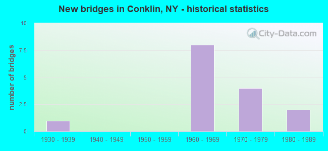
- New bridges - historical statistics
- 11930-1939
- 81960-1969
- 41970-1979
- 21980-1989
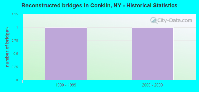
- Reconstructed bridges - Historical Statistics
- 11990-1999
- 12000-2009
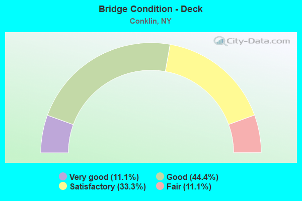
- Bridge Condition - Deck
- 11.1%Very good
- 44.4%Good
- 33.3%Satisfactory
- 11.1%Fair
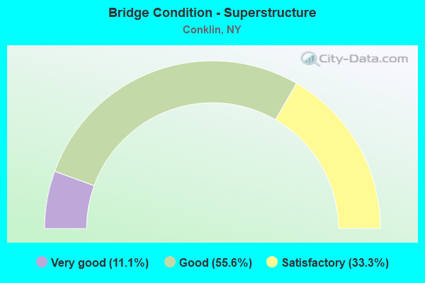
- Bridge Condition - Superstructure
- 11.1%Very good
- 55.6%Good
- 33.3%Satisfactory
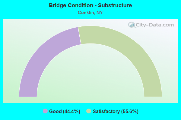
- Bridge Condition - Substructure
- 44.4%Good
- 55.6%Satisfactory
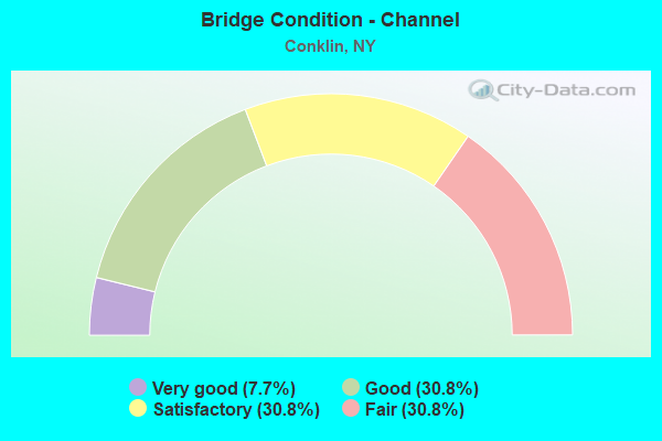
- Bridge Condition - Channel
- 7.7%Very good
- 30.8%Good
- 30.8%Satisfactory
- 30.8%Fair
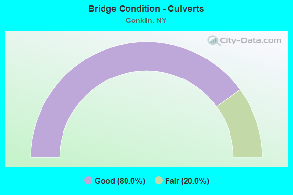
- Bridge Condition - Culverts
- 80.0%Good
- 20.0%Fair
Find on map >> Show street view
Structure Number: 100356, Location: 0.2 MI NW JCT RTS 7A + 7 (Lat: 42.017056, Lng: -75.791286), Route carried "on" structure: State highway 7, Year Built: 1968, Status: Open, Structure Length: 0.76m (2.49ft), Average Daily Traffic: 3,080 (year 2016), Truck Traffic: 4%, Average Future Daily Traffic: 3,810 (year 2040), Design Load: HS 15, Features Intersected: CONKLIN CREEK
Minimum Vertical Clearance: 30+ m (98+ ft), Kilometerpoint: 2.237, Lanes on structure: 2, Base Highway Network: Yes, Owner: State Highway Agency, Approaching Roadway Width: 13.4m (44.0ft), Skew: 1 degrees, Material/Design: Concrete, Design/Construction: Culvert, Number Of Spans In Main Unit: 1, Length of Maximum Span: 7.3m (24.0ft), Curb-To-Curb Width: 13.1m (43.0ft), Out-to-Out Width: 14.1m (46.3ft)
Condition: Channel: Good, Culverts: Fair, Operating Rating: 57.2 metric tons, Method Used To Determine Operating Rating: Load Factor (LF), Inventory Rating: 34.5 metric tons, Method Used To Determine Inventory Rating: Load Factor (LF), Structural Evaluation: Somewhat better than minimum adequacy, Deck Geometry: Equal to present minimum criteria, Waterway Adequacy: Equal to present desirable criteria, Approach Roadway Alignment: Equal to present desirable criteria, Length Of Structure Improvement: 0.76m (2.49ft), Designated Inspection Frequency: Every 24 months, Inspection Date: May 2020, Bridge Improvement Cost: $189,000, Roadway Improvement Cost: $111,000, Total Project Cost: $300,000 ( Estimate for 2021), Wearing Surface/Protective System: Wearing Surface: Monolithic Concrete
Find on map >> Show street view
Structure Number: 100358, Location: 2.1 MI NW JCT SH 7 & SH7A (Lat: 42.041464, Lng: -75.806803), Route carried "on" structure: State highway 7, Year Built: 1968, Status: Open, Structure Length: 10.64m (34.91ft), Average Daily Traffic: 3,350 (year 2020), Truck Traffic: 9%, Average Future Daily Traffic: 4,069 (year 2040), Design Load: HS 20+Mod, Features Intersected: NORFOLK SOUTHERN RR
Minimum Vertical Clearance: 30+ m (98+ ft), Kilometerpoint: 5.294, Lanes on structure: 2, Base Highway Network: Yes, Owner: State Highway Agency, Approaching Roadway Width: 13.4m (44.0ft), Skew: 6 degrees, Material/Design: Steel, Design/Construction: Stringer/Multi-beam, Number Of Spans In Main Unit: 3, Length of Maximum Span: 36.5m (119.8ft), Curb or Sidewalk Widths: Left: 0.5m (1.6ft), Right: 0.5m (1.6ft), Curb-To-Curb Width: 8.5m (27.9ft), Out-to-Out Width: 10.1m (33.1ft)
Condition: Deck: Satisfactory, Superstructure: Satisfactory, Substructure: Good, Operating Rating: 46.3 metric tons, Method Used To Determine Operating Rating: Load Factor (LF), Inventory Rating: 27.2 metric tons, Method Used To Determine Inventory Rating: Load Factor (LF), Structural Evaluation: Equal to present minimum criteria, Deck Geometry: Meets minimum limits, Underclear: Somewhat better than minimum adequacy, Approach Roadway Alignment: Equal to present desirable criteria, Length Of Structure Improvement: 10.63m (34.88ft), Designated Inspection Frequency: Every 24 months, Inspection Date: June 2020, Bridge Improvement Cost: $2,540,000, Roadway Improvement Cost: $1,487,000, Total Project Cost: $4,027,000 ( Estimate for 2021), Deck Structure Type: Concrete Cast-file-Place, Wearing Surface/Protective System: Wearing Surface: Integral Concrete
Find on map >> Show street view
Structure Number: 100435, Location: 0.1 MI SE JCT SH 7 + SH 7 (Lat: 42.015236, Lng: -75.788778), Route carried "on" structure: State highway 7A, Year Built: 1968, Status: Open, Structure Length: 4.45m (14.60ft), Average Daily Traffic: 1,390 (year 2016), Truck Traffic: 5%, Average Future Daily Traffic: 1,719 (year 2040), Design Load: HS 15, Features Intersected: SNAKE CREEK
Minimum Vertical Clearance: 30+ m (98+ ft), Kilometerpoint: 2.767, Lanes on structure: 2, Base Highway Network: Yes, Owner: State Highway Agency, Approaching Roadway Width: 13.4m (44.0ft), Skew: 3 degrees, Material/Design: Steel, Design/Construction: Stringer/Multi-beam, Number Of Spans In Main Unit: 2, Length of Maximum Span: 21.3m (69.9ft), Curb or Sidewalk Widths: Left: 0.5m (1.6ft), Right: 0.5m (1.6ft), Curb-To-Curb Width: 8.5m (27.9ft), Out-to-Out Width: 10.1m (33.1ft)
Condition: Deck: Good, Superstructure: Good, Substructure: Satisfactory, Channel: Satisfactory, Operating Rating: 88.0 metric tons, Method Used To Determine Operating Rating: Load Factor (LF), Inventory Rating: 52.6 metric tons, Method Used To Determine Inventory Rating: Load Factor (LF), Structural Evaluation: Equal to present minimum criteria, Deck Geometry: Somewhat better than minimum adequacy, Waterway Adequacy: Somewhat better than minimum adequacy, Approach Roadway Alignment: Equal to present desirable criteria, Length Of Structure Improvement: 4.45m (14.60ft), Designated Inspection Frequency: Every 24 months, Inspection Date: July 2020, Bridge Improvement Cost: $1,192,000, Roadway Improvement Cost: $698,000, Total Project Cost: $1,890,000 ( Estimate for 2021), Deck Structure Type: Concrete Cast-file-Place, Wearing Surface/Protective System: Wearing Surface: Integral Concrete
Find on map >> Show street view
Structure Number: 105439, Location: 1.1 MI NW JCT RTS 7 + 7A (Lat: 42.027633, Lng: -75.801844), Route carried "on" structure: State highway 7, Year Built: 1968, Status: Open, Structure Length: 2.90m (9.51ft), Average Daily Traffic: 3,080 (year 2016), Truck Traffic: 4%, Average Future Daily Traffic: 3,810 (year 2040), Design Load: HS 20+Mod, Features Intersected: LITTLE SNAKE
Minimum Vertical Clearance: 30+ m (98+ ft), Kilometerpoint: 3.701, Lanes on structure: 2, Base Highway Network: Yes, Owner: State Highway Agency, Approaching Roadway Width: 13.4m (44.0ft), Skew: 2 degrees, Material/Design: Steel, Design/Construction: Stringer/Multi-beam, Number Of Spans In Main Unit: 1, Length of Maximum Span: 27.4m (89.9ft), Curb or Sidewalk Widths: Left: 0.5m (1.6ft), Right: 0.5m (1.6ft), Curb-To-Curb Width: 9.8m (32.2ft), Out-to-Out Width: 11.3m (37.1ft)
Condition: Deck: Satisfactory, Superstructure: Satisfactory, Substructure: Satisfactory, Channel: Satisfactory, Operating Rating: 60.8 metric tons, Method Used To Determine Operating Rating: Load Factor (LF), Inventory Rating: 36.3 metric tons, Method Used To Determine Inventory Rating: Load Factor (LF), Structural Evaluation: Equal to present minimum criteria, Deck Geometry: Meets minimum limits, Waterway Adequacy: Equal to present desirable criteria, Approach Roadway Alignment: Equal to present desirable criteria, Length Of Structure Improvement: 2.89m (9.48ft), Designated Inspection Frequency: Every 24 months, Inspection Date: May 2020, Bridge Improvement Cost: $1,036,000, Roadway Improvement Cost: $606,000, Total Project Cost: $1,642,000 ( Estimate for 2021), Deck Structure Type: Concrete Cast-file-Place, Wearing Surface/Protective System: Wearing Surface: Integral Concrete
Find on map >> Show street view
Structure Number: 222549, Location: 1 MI NW OF CORBETTSVILLE (Lat: 42.030469, Lng: -75.808567), Route carried "on" structure: Other road , Year Built: 1974, Year Reconstructed: 2008, Status: Open, Structure Length: 1.86m (6.10ft), Average Daily Traffic: 189 (year 2018), Truck Traffic: 5%, Average Future Daily Traffic: 265 (year 2038), Design Load: H 20, Features Intersected: LITTLE SNAKE CREEK, Facility Carried by Structure: FALLBROOK ROAD
Minimum Vertical Clearance: 30+ m (98+ ft), Kilometerpoint: 3.829, Lanes on structure: 2, Owner: Town or Township Highway Agency, Approaching Roadway Width: 6.1m (20.0ft), Skew: 2 degrees, Material/Design: Steel, Design/Construction: Stringer/Multi-beam, Number Of Spans In Main Unit: 1, Length of Maximum Span: 17.0m (55.8ft), Curb-To-Curb Width: 7.3m (24.0ft), Out-to-Out Width: 8.2m (26.9ft)
Condition: Deck: Fair, Superstructure: Good, Substructure: Good, Channel: Good, Operating Rating: 62.6 metric tons, Method Used To Determine Operating Rating: Load Factor (LF), Inventory Rating: 37.2 metric tons, Method Used To Determine Inventory Rating: Load Factor (LF), Structural Evaluation: Better than present minimum criteria, Deck Geometry: Somewhat better than minimum adequacy, Waterway Adequacy: Somewhat better than minimum adequacy, Approach Roadway Alignment: Equal to present desirable criteria, Length Of Structure Improvement: 1.85m (6.07ft), Designated Inspection Frequency: Every 24 months, Inspection Date: August 2020, Bridge Improvement Cost: $622,000, Roadway Improvement Cost: $364,000, Total Project Cost: $986,000 ( Estimate for 2021), Deck Structure Type: Concrete Cast-file-Place, Wearing Surface/Protective System: Wearing Surface: Bituminous
Find on map >> Show street view
Structure Number: 225761, Location: HAMLET OF CORBETTSVILLE (Lat: 42.016639, Lng: -75.792094), Route carried "on" structure: Other road , Year Built: 1973, Status: Open, Structure Length: 0.82m (2.69ft), Average Daily Traffic: 254 (year 2016), Truck Traffic: 7%, Average Future Daily Traffic: 356 (year 2036), Features Intersected: TRIB SUSQUEHANNA, Facility Carried by Structure: CORBETTSVILLE RD
Minimum Vertical Clearance: 30+ m (98+ ft), Kilometerpoint: 0.257, Lanes on structure: 2, Owner: Town or Township Highway Agency, Approaching Roadway Width: 8.2m (26.9ft), Skew: 2 degrees, Material/Design: Concrete, Design/Construction: Culvert, Number Of Spans In Main Unit: 1, Length of Maximum Span: 7.6m (24.9ft), Curb or Sidewalk Widths: Left: 1.2m (3.9ft), Right: 0.0m, Curb-To-Curb Width: 11.0m (36.1ft), Out-to-Out Width: 13.0m (42.7ft)
Condition: Channel: Fair, Culverts: Good, Operating Rating: 78.0 metric tons, Method Used To Determine Operating Rating: Field evaluation and documented engineering judgment, Inventory Rating: 32.7 metric tons, Method Used To Determine Inventory Rating: Field evaluation and documented engineering judgment, Structural Evaluation: Better than present minimum criteria, Deck Geometry: Equal to present desirable criteria, Waterway Adequacy: Meets minimum limits, Approach Roadway Alignment: Equal to present desirable criteria, Length Of Structure Improvement: 0.82m (2.69ft), Designated Inspection Frequency: Every 24 months, Inspection Date: June 2020, Bridge Improvement Cost: $308,000, Roadway Improvement Cost: $180,000, Total Project Cost: $488,000 ( Estimate for 2021), Wearing Surface/Protective System: Wearing Surface: Bituminous
Find on map >> Show street view
Structure Number: 226669, Location: .2 MI W OF CORBETTSVILLE (Lat: 42.014567, Lng: -75.795664), Route carried "on" structure: Other road , Year Built: 1974, Status: Open, Structure Length: 1.74m (5.71ft), Average Daily Traffic: 233 (year 2019), Truck Traffic: 7%, Average Future Daily Traffic: 326 (year 2039), Design Load: HS 20, Features Intersected: TRIB SUSQUEHANNA RIVER, Facility Carried by Structure: BANTA ROAD
Minimum Vertical Clearance: 30+ m (98+ ft), Kilometerpoint: 0.386, Lanes on structure: 2, Owner: Town or Township Highway Agency, Approaching Roadway Width: 5.9m (19.4ft), Skew: 7 degrees, Material/Design: Steel, Design/Construction: Culvert, Number Of Spans In Main Unit: 2, Length of Maximum Span: 6.7m (22.0ft)
Condition: Channel: Fair, Culverts: Good, Operating Rating: 77.3 metric tons, Method Used To Determine Operating Rating: Field evaluation and documented engineering judgment, Inventory Rating: 32.7 metric tons, Method Used To Determine Inventory Rating: Field evaluation and documented engineering judgment, Structural Evaluation: Better than present minimum criteria, Waterway Adequacy: Somewhat better than minimum adequacy, Approach Roadway Alignment: Equal to present minimum criteria, Length Of Structure Improvement: 1.73m (5.68ft), Designated Inspection Frequency: Every 24 months, Inspection Date: August 2020, Bridge Improvement Cost: $210,000, Roadway Improvement Cost: $123,000, Total Project Cost: $332,000 ( Estimate for 2021)
Find on map >> Show street view
Structure Number: 334925, Location: HAMLET OF CONKLIN (Lat: 42.036228, Lng: -75.803828), Route carried "on" structure: County highway , Year Built: 1966, Status: Open, Structure Length: 19.57m (64.21ft), Average Daily Traffic: 6,055 (year 2019), Truck Traffic: 16%, Average Future Daily Traffic: 7,355 (year 2040), Design Load: HS 20, Features Intersected: DELAWARE & HUDSON, SUSQU, Facility Carried by Structure: COUNTY ROAD 20
Minimum Vertical Clearance: 30+ m (98+ ft), Kilometerpoint: 0.241, Lanes on structure: 2, Owner: County Highway Agency, Approaching Roadway Width: 9.1m (29.9ft), Material/Design: Steel, Design/Construction: Stringer/Multi-beam, Number Of Spans In Main Unit: 5, Length of Maximum Span: 39.6m (129.9ft), Curb-To-Curb Width: 9.1m (29.9ft), Out-to-Out Width: 10.1m (33.1ft)
Condition: Deck: Good, Superstructure: Good, Substructure: Satisfactory, Channel: Good, Operating Rating: 40.8 metric tons, Method Used To Determine Operating Rating: Load Factor (LF), Inventory Rating: 24.5 metric tons, Method Used To Determine Inventory Rating: Load Factor (LF), Structural Evaluation: Equal to present minimum criteria, Deck Geometry: Meets minimum limits, Underclear: Superior to present desirable criteria, Waterway Adequacy: Equal to present minimum criteria, Approach Roadway Alignment: Equal to present desirable criteria, Length Of Structure Improvement: 19.56m (64.17ft), Designated Inspection Frequency: Every 24 months, Inspection Date: July 2021, Bridge Improvement Cost: $4,172,000, Roadway Improvement Cost: $2,443,000, Total Project Cost: $6,616,000 ( Estimate for 2021), Deck Structure Type: Concrete Cast-file-Place, Wearing Surface/Protective System: Wearing Surface: Monolithic Concrete
Find on map >> Show street view
Structure Number: 334926, Location: 4.0 MI WEST OF CONKLIN (Lat: 42.013153, Lng: -75.862078), Route carried "on" structure: County highway , Year Built: 1966, Status: Open, Structure Length: 1.07m (3.51ft), Average Daily Traffic: 217 (year 2017), Truck Traffic: 7%, Average Future Daily Traffic: 304 (year 2037), Design Load: HS 20, Features Intersected: LITTLE SNAKE CREEK, Facility Carried by Structure: BRADY HILL ROAD
Minimum Vertical Clearance: 30+ m (98+ ft), Kilometerpoint: 4.232, Lanes on structure: 2, Owner: County Highway Agency, Approaching Roadway Width: 9.8m (32.2ft), Skew: 2 degrees, Material/Design: Steel, Design/Construction: Stringer/Multi-beam, Number Of Spans In Main Unit: 1, Length of Maximum Span: 10.3m (33.8ft), Curb-To-Curb Width: 10.1m (33.1ft), Out-to-Out Width: 11.6m (38.1ft)
Condition: Deck: Satisfactory, Superstructure: Good, Substructure: Satisfactory, Channel: Satisfactory, Operating Rating: 39.9 metric tons, Method Used To Determine Operating Rating: Load Factor (LF), Inventory Rating: 23.6 metric tons, Method Used To Determine Inventory Rating: Load Factor (LF), Structural Evaluation: Equal to present minimum criteria, Deck Geometry: Better than present minimum criteria, Waterway Adequacy: Somewhat better than minimum adequacy, Approach Roadway Alignment: Equal to present desirable criteria, Length Of Structure Improvement: 1.06m (3.48ft), Designated Inspection Frequency: Every 24 months, Inspection Date: October 2020, Bridge Improvement Cost: $601,000, Roadway Improvement Cost: $352,000, Total Project Cost: $953,000 ( Estimate for 2021), Deck Structure Type: Concrete Cast-file-Place, Wearing Surface/Protective System: Wearing Surface: Bituminous
Find on map >> Show street view
Structure Number: 334927, Location: IN CONKLIN FORKS (Lat: 42.023672, Lng: -75.855333), Route carried "on" structure: County highway , Year Built: 1939, Year Reconstructed: 1995, Status: Open, Structure Length: 1.83m (6.00ft), Average Daily Traffic: 533 (year 2017), Truck Traffic: 7%, Average Future Daily Traffic: 746 (year 2037), Features Intersected: LITTLE SNAKE CREEK, Facility Carried by Structure: CONKLIN FORKS ROAD
Minimum Vertical Clearance: 30+ m (98+ ft), Kilometerpoint: 0.016, Lanes on structure: 2, Owner: County Highway Agency, Approaching Roadway Width: 6.7m (22.0ft), Skew: 3 degrees, Material/Design: Steel, Design/Construction: Stringer/Multi-beam, Number Of Spans In Main Unit: 1, Length of Maximum Span: 17.3m (56.8ft), Curb-To-Curb Width: 7.3m (24.0ft), Out-to-Out Width: 8.0m (26.2ft)
Condition: Deck: Very good, Superstructure: Very good, Substructure: Good, Channel: Satisfactory, Operating Rating: 82.6 metric tons, Method Used To Determine Operating Rating: Load Factor (LF), Inventory Rating: 49.0 metric tons, Method Used To Determine Inventory Rating: Load Factor (LF), Structural Evaluation: Better than present minimum criteria, Deck Geometry: Meets minimum limits, Waterway Adequacy: Somewhat better than minimum adequacy, Approach Roadway Alignment: Meets minimum limits, Length Of Structure Improvement: 1.82m (5.97ft), Designated Inspection Frequency: Every 24 months, Inspection Date: April 2021, Bridge Improvement Cost: $542,000, Roadway Improvement Cost: $318,000, Total Project Cost: $860,000 ( Estimate for 2021), Deck Structure Type: Concrete Cast-file-Place, Wearing Surface/Protective System: Wearing Surface: Integral Concrete, Deck Protection: Epoxy Coated Reinforcing
Find on map >> Show street view
Structure Number: 334928, Location: 3.0 MI WEST OF CONKLIN (Lat: 42.023492, Lng: -75.856161), Route carried "on" structure: County highway , Year Built: 1971, Status: Open, Structure Length: 1.98m (6.50ft), Average Daily Traffic: 305 (year 2018), Truck Traffic: 5%, Average Future Daily Traffic: 427 (year 2038), Design Load: HS 20, Features Intersected: LITTLE SNAKE CREEK, Facility Carried by Structure: PIERCE CREEK RD
Minimum Vertical Clearance: 30+ m (98+ ft), Kilometerpoint: 0.048, Lanes on structure: 2, Owner: County Highway Agency, Approaching Roadway Width: 6.7m (22.0ft), Skew: 4 degrees, Material/Design: Steel, Design/Construction: Stringer/Multi-beam, Number Of Spans In Main Unit: 1, Length of Maximum Span: 18.8m (61.7ft), Curb or Sidewalk Widths: Left: 1.6m (5.2ft), Right: 0.0m, Curb-To-Curb Width: 9.8m (32.2ft), Out-to-Out Width: 12.2m (40.0ft)
Condition: Deck: Good, Superstructure: Good, Substructure: Good, Channel: Fair, Operating Rating: 65.3 metric tons, Method Used To Determine Operating Rating: Load Factor (LF), Inventory Rating: 39.0 metric tons, Method Used To Determine Inventory Rating: Load Factor (LF), Structural Evaluation: Better than present minimum criteria, Deck Geometry: Better than present minimum criteria, Waterway Adequacy: Meets minimum limits, Approach Roadway Alignment: Equal to present minimum criteria, Length Of Structure Improvement: 1.98m (6.50ft), Designated Inspection Frequency: Every 24 months, Inspection Date: August 2020, Bridge Improvement Cost: $919,000, Roadway Improvement Cost: $538,000, Total Project Cost: $1,458,000 ( Estimate for 2021), Deck Structure Type: Concrete Cast-file-Place, Wearing Surface/Protective System: Wearing Surface: Bituminous
Find on map >> Show street view
Structure Number: 334929, Location: 2.7 MI WEST OF CONKLIN (Lat: 42.026458, Lng: -75.858839), Route carried "on" structure: County highway , Year Built: 1983, Status: Open, Structure Length: 1.13m (3.71ft), Average Daily Traffic: 305 (year 2018), Truck Traffic: 5%, Average Future Daily Traffic: 427 (year 2038), Design Load: H 20, Features Intersected: W FORK LITTLE SNAKE CREE, Facility Carried by Structure: PIERCE CREEK RD
Minimum Vertical Clearance: 30+ m (98+ ft), Kilometerpoint: 0.483, Lanes on structure: 2, Owner: County Highway Agency, Approaching Roadway Width: 6.1m (20.0ft), Skew: 4 degrees, Material/Design: Steel, Design/Construction: Culvert, Number Of Spans In Main Unit: 1, Length of Maximum Span: 10.9m (35.8ft)
Condition: Channel: Very good, Culverts: Good, Operating Rating: 62.4 metric tons, Method Used To Determine Operating Rating: Field evaluation and documented engineering judgment, Inventory Rating: 26.3 metric tons, Method Used To Determine Inventory Rating: Field evaluation and documented engineering judgment, Structural Evaluation: Equal to present minimum criteria, Waterway Adequacy: Equal to present minimum criteria, Approach Roadway Alignment: Equal to present desirable criteria, Length Of Structure Improvement: 1.12m (3.67ft), Designated Inspection Frequency: Every 24 months, Inspection Date: August 2020, Bridge Improvement Cost: $122,000, Roadway Improvement Cost: $71,000, Total Project Cost: $193,000 ( Estimate for 2021)
Find on map >> Show street view
Structure Number: 335869, Location: AT CONKLIN (Lat: 42.095319, Lng: -75.837906), Route carried "on" structure: Business County highway , Year Built: 1964, Status: Open, Structure Length: 17.89m (58.69ft), Average Daily Traffic: 6,290 (year 2019), Truck Traffic: 10%, Average Future Daily Traffic: 7,641 (year 2040), Design Load: HS 20+Mod, Features Intersected: RTE 7, SUSQUEHANNA RIVER, Facility Carried by Structure: COUNTY ROAD 177
Minimum Vertical Clearance: 30+ m (98+ ft), Kilometerpoint: 0.370, Lanes on structure: 2, Lanes under structure: 2, Owner: County Highway Agency, Approaching Roadway Width: 9.8m (32.2ft), Material/Design: Steel, Design/Construction: Stringer/Multi-beam, Number Of Spans In Main Unit: 5, Length of Maximum Span: 35.6m (116.8ft), Curb or Sidewalk Widths: Left: 0.3m (1.0ft), Right: 0.3m (1.0ft), Curb-To-Curb Width: 8.5m (27.9ft), Out-to-Out Width: 10.2m (33.5ft)
Condition: Deck: Good, Superstructure: Satisfactory, Substructure: Satisfactory, Channel: Good, Operating Rating: 63.5 metric tons, Method Used To Determine Operating Rating: Load Factor (LF), Inventory Rating: 38.1 metric tons, Method Used To Determine Inventory Rating: Load Factor (LF), Structural Evaluation: Equal to present minimum criteria, Deck Geometry: Meets minimum limits, Underclear: Meets minimum limits, Waterway Adequacy: Somewhat better than minimum adequacy, Approach Roadway Alignment: Equal to present desirable criteria, Length Of Structure Improvement: 17.89m (58.69ft), Designated Inspection Frequency: Every 24 months, Underwater Inspection Frequency: Every 60 months, Inspection Date: October 2021, Underwater Inspection Date: June 2016, Bridge Improvement Cost: $3,786,000, Roadway Improvement Cost: $2,217,000, Total Project Cost: $6,003,000 ( Estimate for 2021), Deck Structure Type: Concrete Cast-file-Place, Wearing Surface/Protective System: Wearing Surface: Monolithic Concrete
Find on map >> Show street view
Structure Number: 33711, Location: 1.28 mi. NW of intersecti (Lat: 42.051342, Lng: -75.816244), Route carried "on" structure: County highway , Year Built: 1985, Status: Open, Structure Length: 0.67m (2.20ft), Average Daily Traffic: 1,510 (year 2017), Truck Traffic: 13%, Average Future Daily Traffic: 1,868 (year 2040), Features Intersected: CARLIN CK, Facility Carried by Structure: CR 197
Minimum Vertical Clearance: 30+ m (98+ ft), Kilometerpoint: 1.995, Lanes on structure: 2, Owner: County Highway Agency, Approaching Roadway Width: 8.2m (26.9ft), Material/Design: Steel, Design/Construction: Culvert, Number Of Spans In Main Unit: 2, Length of Maximum Span: 2.7m (8.9ft), Curb or Sidewalk Widths: Left: 0.0m, Right: 3.7m (12.1ft)
Condition: Channel: Fair, Culverts: Good, Operating Rating: 74.5 metric tons, Method Used To Determine Operating Rating: Field evaluation and documented engineering judgment, Inventory Rating: 32.7 metric tons, Method Used To Determine Inventory Rating: Field evaluation and documented engineering judgment, Structural Evaluation: Better than present minimum criteria, Waterway Adequacy: Equal to present desirable criteria, Approach Roadway Alignment: Equal to present desirable criteria, Length Of Structure Improvement: 0.67m (2.20ft), Designated Inspection Frequency: Every 24 months, Inspection Date: April 2020, Bridge Improvement Cost: $98,000, Roadway Improvement Cost: $57,000, Total Project Cost: $155,000 ( Estimate for 2021)
Find on map >> Show street view
Structure Number: 335869, Location: AT CONKLIN (Lat: 42.095319, Lng: -75.837906), Route carried "under" structure: State highway 7, Year Built: 1964, Structure Length: 0. m, Average Daily Traffic: 4,303 (year 2011), Features Intersected: RTE 7, SUSQUEHANNA RIVER
Minimum Vertical Clearance: 4.39m (14.40ft), Kilometerpoint: 12.068, Lanes on structure: 2, Lanes under structure: 2, Material/Design: Steel, Design/Construction: Stringer/Multi-beam, Length of Maximum Span: 35.6m (116.8ft)