Bridge Statistics for Copperas Cove, Texas (TX)
Condition, Traffic, Stress, Structural Evaluation, Project Costs
- National Bridge Inventory (NBI) Statistics
- 45Number of bridges
- 991ft / 302mTotal length
- $12,208,000Total costs
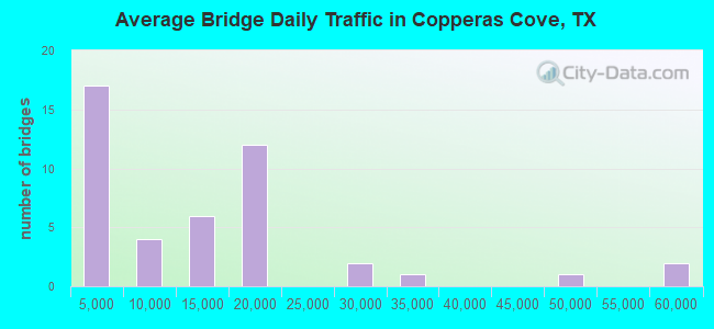
- 564,724Total average daily traffic
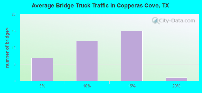
- 34,078Total average daily truck traffic
- National Bridge Inventory (NBI) Registered Bridges for Copperas Cove
- No street view available for this location
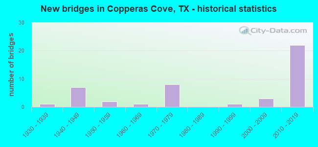
- New bridges - historical statistics
- 11930-1939
- 71940-1949
- 21950-1959
- 11960-1969
- 81970-1979
- 11990-1999
- 32000-2009
- 222010-2019
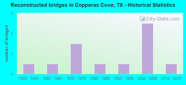
- Reconstructed bridges - Historical Statistics
- 11950-1959
- 11960-1969
- 31970-1979
- 11980-1989
- 11990-1999
- 52000-2009
- 12010-2019
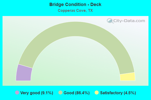
- Bridge Condition - Deck
- 9.1%Very good
- 86.4%Good
- 4.5%Satisfactory
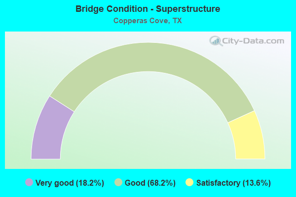
- Bridge Condition - Superstructure
- 18.2%Very good
- 68.2%Good
- 13.6%Satisfactory
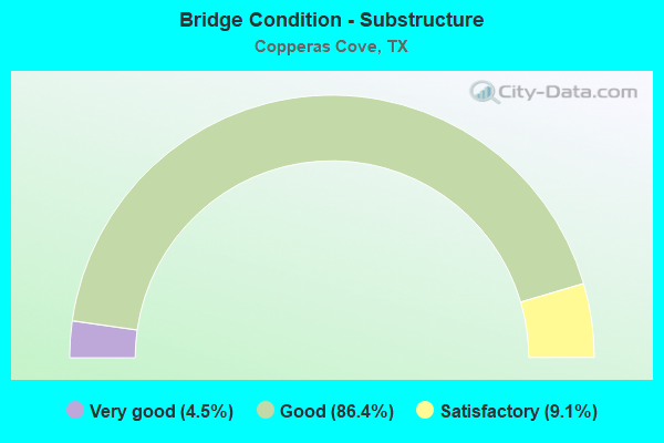
- Bridge Condition - Substructure
- 4.5%Very good
- 86.4%Good
- 9.1%Satisfactory
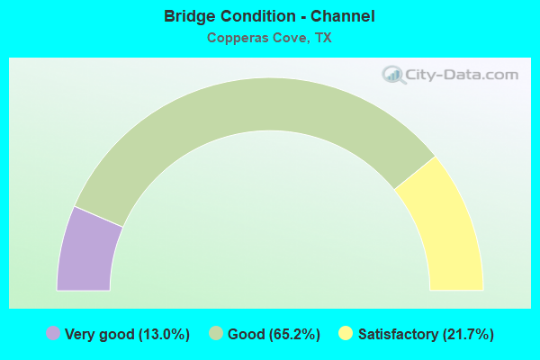
- Bridge Condition - Channel
- 13.0%Very good
- 65.2%Good
- 21.7%Satisfactory
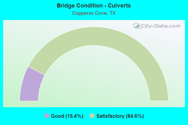
- Bridge Condition - Culverts
- 15.4%Good
- 84.6%Satisfactory
Find on map >> Show street view
Structure Number: 90140AA0546001, Location: 1.30 MI W OF IVY GAP RD (Lat: 31.061583, Lng: -97.892744), Route carried "on" structure: County highway , Year Built: 1977, Year Reconstructed: 2001, Status: Open, Structure Length: 1.31m (4.30ft), Average Daily Traffic: 2,286 (year 2015), Average Future Daily Traffic: 900 (year 2033), Features Intersected: CLEAR CREEK #2, Facility Carried by Structure: BOYS RANCH RD
Minimum Vertical Clearance: 30+ m (98+ ft), Kilometerpoint: 2.092, Lanes on structure: 2, Owner: County Highway Agency, Approaching Roadway Width: 7.9m (25.9ft), Material/Design: Concrete, Design/Construction: Culvert, Number Of Spans In Main Unit: 4, Length of Maximum Span: 3.0m (9.8ft), Curb-To-Curb Width: 10.7m (35.1ft), Out-to-Out Width: 11.1m (36.4ft)
Condition: Channel: Satisfactory, Culverts: Satisfactory, Operating Rating: 32.7 metric tons, Method Used To Determine Operating Rating: Field evaluation and documented engineering judgment, Inventory Rating: 24.5 metric tons, Method Used To Determine Inventory Rating: Field evaluation and documented engineering judgment, Structural Evaluation: Equal to present minimum criteria, Deck Geometry: Somewhat better than minimum adequacy, Waterway Adequacy: Meets minimum limits, Approach Roadway Alignment: Better than present minimum criteria, Length Of Structure Improvement: 1.83m (6.00ft), Designated Inspection Frequency: Every 24 months, Inspection Date: November 2021, Bridge Improvement Cost: $167,000, Roadway Improvement Cost: $41,000, Total Project Cost: $208,000, Deck Structure Type: Concrete Cast-file-Place, Wearing Surface/Protective System: Wearing Surface: Bituminous
Find on map >> Show street view
Structure Number: 90500005503042, Location: 1.50 MI W OF FM 183 (Lat: 31.469869, Lng: -97.997747), Route carried "on" structure: US 84, Year Built: 1939, Year Reconstructed: 1964, Status: Open, Structure Length: 8.72m (28.61ft), Average Daily Traffic: 2,325 (year 2020), Truck Traffic: 13%, Average Future Daily Traffic: 3,040 (year 2033), Design Load: H 15, Features Intersected: COWHOUSE CREEK
Minimum Vertical Clearance: 30+ m (98+ ft), Kilometerpoint: 14.445, Lanes on structure: 2, Owner: State Highway Agency, Approaching Roadway Width: 14.0m (45.9ft), Material/Design: Steel continuous, Design/Construction: Stringer/Multi-beam, Number Of Spans In Main Unit: 3, Number Of Approach Spans: 2, Length of Maximum Span: 25.9m (85.0ft), Curb-To-Curb Width: 12.8m (42.0ft), Out-to-Out Width: 13.5m (44.3ft)
Condition: Deck: Satisfactory, Superstructure: Satisfactory, Substructure: Good, Channel: Good, Operating Rating: 47.2 metric tons, Method Used To Determine Operating Rating: Load Factor (LF), Inventory Rating: 29.0 metric tons, Method Used To Determine Inventory Rating: Load Factor (LF), Structural Evaluation: Equal to present minimum criteria, Deck Geometry: Equal to present minimum criteria, Waterway Adequacy: Equal to present minimum criteria, Approach Roadway Alignment: Equal to present desirable criteria, Length Of Structure Improvement: 10.88m (35.70ft), Designated Inspection Frequency: Every 24 months, Inspection Date: December 2020, Bridge Improvement Cost: $1,100,000, Roadway Improvement Cost: $300,000, Total Project Cost: $1,700,000, Deck Structure Type: Concrete Cast-file-Place, Wearing Surface/Protective System: Wearing Surface: Bituminous
Find on map >> Show street view
Structure Number: 90500023102002, Location: 6.9 MI E OF LAMPASAS C/L (Lat: 31.121958, Lng: -97.820450), Route carried "on" structure: US 190, Year Built: 2007, Status: Open, Structure Length: 6.10m (20.01ft), Average Daily Traffic: 27,790 (year 2013), Truck Traffic: 4%, Average Future Daily Traffic: 38,900 (year 2033), Design Load: HS 20, Features Intersected: CLEAR CREEK
Minimum Vertical Clearance: 30+ m (98+ ft), Kilometerpoint: 12.680, Lanes on structure: 3, Owner: State Highway Agency, Approaching Roadway Width: 18.9m (62.0ft), Material/Design: Prestressed concrete, Design/Construction: Stringer/Multi-beam, Number Of Spans In Main Unit: 2, Number Of Approach Spans: 1, Length of Maximum Span: 22.9m (75.1ft), Curb-To-Curb Width: 19.1m (62.7ft), Out-to-Out Width: 19.7m (64.6ft)
Condition: Deck: Good, Superstructure: Good, Substructure: Good, Channel: Good, Operating Rating: 54.4 metric tons, Method Used To Determine Operating Rating: Assigned rating based on Load Factor Design (LFD) reported in metric tons, Inventory Rating: 32.7 metric tons, Method Used To Determine Inventory Rating: Assigned rating based on Load Factor Design (LFD) reported in metric tons, Structural Evaluation: Better than present minimum criteria, Deck Geometry: Superior to present desirable criteria, Waterway Adequacy: Superior to present desirable criteria, Approach Roadway Alignment: Equal to present desirable criteria, Designated Inspection Frequency: Every 24 months, Inspection Date: October 2020, Deck Structure Type: Concrete Precast Panels, Wearing Surface/Protective System: Wearing Surface: Bituminous
Find on map >> Show street view
Structure Number: 90500023102028, Location: 0.73 MI SW OF FM 116 (Lat: 31.105275, Lng: -97.920458), Route carried "on" structure: State highway 190, Year Built: 1943, Year Reconstructed: 1983, Status: Open, Structure Length: 0.76m (2.49ft), Average Daily Traffic: 8,840 (year 2013), Truck Traffic: 13%, Average Future Daily Traffic: 12,380 (year 2033), Design Load: H 15, Features Intersected: CLEAR CREEK
Minimum Vertical Clearance: 30+ m (98+ ft), Kilometerpoint: 2.620, Lanes on structure: 5, Owner: State Highway Agency, Approaching Roadway Width: 25.9m (85.0ft), Material/Design: Concrete, Design/Construction: Culvert, Number Of Spans In Main Unit: 3, Length of Maximum Span: 2.1m (6.9ft), Out-to-Out Width: 38.2m (125.3ft)
Condition: Channel: Satisfactory, Culverts: Satisfactory, Operating Rating: 39.9 metric tons, Method Used To Determine Operating Rating: Load Factor (LF), Inventory Rating: 23.6 metric tons, Method Used To Determine Inventory Rating: Load Factor (LF), Structural Evaluation: Somewhat better than minimum adequacy, Waterway Adequacy: Equal to present minimum criteria, Approach Roadway Alignment: Equal to present desirable criteria, Length Of Structure Improvement: 1.83m (6.00ft), Designated Inspection Frequency: Every 24 months, Inspection Date: October 2020, Bridge Improvement Cost: $200,000, Roadway Improvement Cost: $100,000, Total Project Cost: $300,000
Find on map >> Show street view
Structure Number: 90500023102029, Location: 1.58 MI NE OF FM 116 (Lat: 31.120169, Lng: -97.887689), Route carried "on" structure: US 190, Year Built: 1943, Year Reconstructed: 1976, Status: Open, Structure Length: 0.67m (2.20ft), Average Daily Traffic: 17,243 (year 2020), Truck Traffic: 6%, Average Future Daily Traffic: 65,840 (year 2033), Design Load: H 15, Features Intersected: TURKEY RUN CREEK
Minimum Vertical Clearance: 30+ m (98+ ft), Kilometerpoint: 6.254, Lanes on structure: 7, Owner: State Highway Agency, Approaching Roadway Width: 28.0m (91.9ft), Material/Design: Concrete, Design/Construction: Culvert, Number Of Spans In Main Unit: 3, Length of Maximum Span: 1.8m (5.9ft), Curb or Sidewalk Widths: Left: 1.0m (3.3ft), Right: 1.4m (4.6ft), Curb-To-Curb Width: 28.0m (91.9ft), Out-to-Out Width: 34.8m (114.2ft)
Condition: Channel: Good, Culverts: Satisfactory, Operating Rating: 39.9 metric tons, Method Used To Determine Operating Rating: Load Factor (LF), Inventory Rating: 23.6 metric tons, Method Used To Determine Inventory Rating: Load Factor (LF), Structural Evaluation: Somewhat better than minimum adequacy, Deck Geometry: Meets minimum limits, Waterway Adequacy: Equal to present minimum criteria, Approach Roadway Alignment: Equal to present desirable criteria, Length Of Structure Improvement: 1.83m (6.00ft), Designated Inspection Frequency: Every 24 months, Inspection Date: October 2020, Bridge Improvement Cost: $200,000, Roadway Improvement Cost: $100,000, Total Project Cost: $300,000
Find on map >> Show street view
Structure Number: 90500023102059, Location: 5.9 MI E OF LAMPASAS C/L (Lat: 31.121567, Lng: -97.837544), Route carried "on" structure: US 190, Year Built: 1975, Year Reconstructed: 2006, Status: Open, Structure Length: 6.25m (20.51ft), Average Daily Traffic: 18,170 (year 2013), Truck Traffic: 6%, Average Future Daily Traffic: 25,430 (year 2033), Design Load: HS 20, Features Intersected: CLARKE RD
Minimum Vertical Clearance: 30+ m (98+ ft), Kilometerpoint: 11.040, Lanes on structure: 3, Lanes under structure: 5, Owner: State Highway Agency, Approaching Roadway Width: 18.9m (62.0ft), Material/Design: Prestressed concrete, Design/Construction: Stringer/Multi-beam, Number Of Spans In Main Unit: 1, Number Of Approach Spans: 2, Length of Maximum Span: 29.0m (95.1ft), Curb-To-Curb Width: 19.5m (64.0ft), Out-to-Out Width: 20.1m (65.9ft)
Condition: Deck: Good, Superstructure: Good, Substructure: Good, Operating Rating: 54.4 metric tons, Method Used To Determine Operating Rating: Assigned rating based on Load Factor Design (LFD) reported in metric tons, Inventory Rating: 32.7 metric tons, Method Used To Determine Inventory Rating: Assigned rating based on Load Factor Design (LFD) reported in metric tons, Structural Evaluation: Better than present minimum criteria, Deck Geometry: Superior to present desirable criteria, Underclear: Meets minimum limits, Approach Roadway Alignment: Equal to present desirable criteria, Length Of Structure Improvement: 8.23m (27.00ft), Designated Inspection Frequency: Every 24 months, Inspection Date: October 2020, Bridge Improvement Cost: $800,000, Roadway Improvement Cost: $200,000, Total Project Cost: $1,200,000, Deck Structure Type: Concrete Cast-file-Place, Wearing Surface/Protective System: Wearing Surface: Bituminous
Find on map >> Show street view
Structure Number: 9050002310206, Location: 5.9 MI E OF LAMPASAS C/L (Lat: 31.122153, Lng: -97.836928), Route carried "on" structure: US 190, Year Built: 1975, Year Reconstructed: 2006, Status: Open, Structure Length: 6.25m (20.51ft), Average Daily Traffic: 18,170 (year 2013), Truck Traffic: 6%, Average Future Daily Traffic: 25,430 (year 2033), Design Load: HS 20, Features Intersected: CLARKE RD
Minimum Vertical Clearance: 30+ m (98+ ft), Kilometerpoint: 11.040, Lanes on structure: 3, Lanes under structure: 5, Owner: State Highway Agency, Approaching Roadway Width: 18.9m (62.0ft), Material/Design: Prestressed concrete, Design/Construction: Stringer/Multi-beam, Number Of Spans In Main Unit: 1, Number Of Approach Spans: 2, Length of Maximum Span: 29.0m (95.1ft), Curb-To-Curb Width: 19.5m (64.0ft), Out-to-Out Width: 20.1m (65.9ft)
Condition: Deck: Good, Superstructure: Good, Substructure: Good, Operating Rating: 54.4 metric tons, Method Used To Determine Operating Rating: Assigned rating based on Load Factor Design (LFD) reported in metric tons, Inventory Rating: 32.7 metric tons, Method Used To Determine Inventory Rating: Assigned rating based on Load Factor Design (LFD) reported in metric tons, Structural Evaluation: Better than present minimum criteria, Deck Geometry: Superior to present desirable criteria, Underclear: Meets minimum limits, Approach Roadway Alignment: Equal to present desirable criteria, Length Of Structure Improvement: 8.23m (27.00ft), Designated Inspection Frequency: Every 24 months, Inspection Date: October 2020, Bridge Improvement Cost: $800,000, Roadway Improvement Cost: $200,000, Total Project Cost: $1,200,000, Deck Structure Type: Concrete Cast-file-Place, Wearing Surface/Protective System: Wearing Surface: Bituminous
Find on map >> Show street view
Structure Number: 90500023102061, Location: 6.9 MI E OF LAMPASAS C/L (Lat: 31.122528, Lng: -97.820219), Route carried "on" structure: US 190, Year Built: 1975, Year Reconstructed: 2006, Status: Open, Structure Length: 5.55m (18.21ft), Average Daily Traffic: 27,790 (year 2013), Truck Traffic: 4%, Average Future Daily Traffic: 38,900 (year 2033), Design Load: HS 20, Features Intersected: CLEAR CREEK
Minimum Vertical Clearance: 30+ m (98+ ft), Kilometerpoint: 12.645, Lanes on structure: 3, Owner: State Highway Agency, Approaching Roadway Width: 18.9m (62.0ft), Material/Design: Concrete, Design/Construction: Stringer/Multi-beam, Number Of Spans In Main Unit: 6, Length of Maximum Span: 9.1m (29.9ft), Curb-To-Curb Width: 19.5m (64.0ft), Out-to-Out Width: 20.1m (65.9ft)
Condition: Deck: Good, Superstructure: Good, Substructure: Good, Channel: Good, Operating Rating: 54.4 metric tons, Method Used To Determine Operating Rating: Assigned rating based on Load Factor Design (LFD) reported in metric tons, Inventory Rating: 32.7 metric tons, Method Used To Determine Inventory Rating: Assigned rating based on Load Factor Design (LFD) reported in metric tons, Structural Evaluation: Better than present minimum criteria, Deck Geometry: Superior to present desirable criteria, Waterway Adequacy: Superior to present desirable criteria, Approach Roadway Alignment: Equal to present desirable criteria, Length Of Structure Improvement: 7.32m (24.02ft), Designated Inspection Frequency: Every 24 months, Inspection Date: October 2020, Bridge Improvement Cost: $700,000, Roadway Improvement Cost: $200,000, Total Project Cost: $1,100,000, Deck Structure Type: Concrete Cast-file-Place, Wearing Surface/Protective System: Wearing Surface: Bituminous
Find on map >> Show street view
Structure Number: 90500023102062, Location: 7.0 MI E OF LAMPASAS C/L (Lat: 31.121908, Lng: -97.818289), Route carried "on" structure: US 190, Year Built: 1941, Year Reconstructed: 2007, Status: Open, Structure Length: 0.85m (2.79ft), Average Daily Traffic: 55,580 (year 2013), Truck Traffic: 4%, Average Future Daily Traffic: 77,810 (year 2033), Design Load: H 15, Features Intersected: CLEAR CREEK RELIEF
Minimum Vertical Clearance: 30+ m (98+ ft), Kilometerpoint: 12.876, Lanes on structure: 8, Owner: State Highway Agency, Approaching Roadway Width: 36.6m (120.1ft), Material/Design: Concrete, Design/Construction: Culvert, Number Of Spans In Main Unit: 3, Length of Maximum Span: 3.0m (9.8ft)
Condition: Channel: Good, Culverts: Satisfactory, Operating Rating: 32.7 metric tons, Method Used To Determine Operating Rating: Field evaluation and documented engineering judgment, Inventory Rating: 24.5 metric tons, Method Used To Determine Inventory Rating: Field evaluation and documented engineering judgment, Structural Evaluation: Equal to present minimum criteria, Waterway Adequacy: Superior to present desirable criteria, Approach Roadway Alignment: Equal to present desirable criteria, Length Of Structure Improvement: 1.83m (6.00ft), Designated Inspection Frequency: Every 24 months, Inspection Date: October 2020, Bridge Improvement Cost: $200,000, Roadway Improvement Cost: $100,000, Total Project Cost: $300,000
Find on map >> Show street view
Structure Number: 90500023102064, Location: 7.3 MI E OF LAMPASAS C/L (Lat: 31.122025, Lng: -97.813642), Route carried "on" structure: County highway , Year Built: 1975, Status: Open, Structure Length: 11.52m (37.80ft), Average Daily Traffic: 7,740 (year 2010), Average Future Daily Traffic: 3,500 (year 2030), Design Load: HS 20, Features Intersected: US 190, Facility Carried by Structure: BELL TOWER RD
Minimum Vertical Clearance: 30+ m (98+ ft), Kilometerpoint: 0.016, Lanes on structure: 2, Lanes under structure: 6, Owner: State Highway Agency, Approaching Roadway Width: 10.4m (34.1ft), Material/Design: Prestressed concrete, Design/Construction: Stringer/Multi-beam, Number Of Spans In Main Unit: 2, Number Of Approach Spans: 2, Length of Maximum Span: 39.3m (128.9ft), Curb-To-Curb Width: 10.4m (34.1ft), Out-to-Out Width: 10.9m (35.8ft)
Condition: Deck: Good, Superstructure: Satisfactory, Substructure: Good, Operating Rating: 54.4 metric tons, Method Used To Determine Operating Rating: Assigned rating based on Load Factor Design (LFD) reported in metric tons, Inventory Rating: 32.7 metric tons, Method Used To Determine Inventory Rating: Assigned rating based on Load Factor Design (LFD) reported in metric tons, Structural Evaluation: Equal to present minimum criteria, Deck Geometry: Meets minimum limits, Underclear: High priority of replacement, Approach Roadway Alignment: Equal to present desirable criteria, Length Of Structure Improvement: 14.39m (47.21ft), Designated Inspection Frequency: Every 24 months, Inspection Date: October 2020, Bridge Improvement Cost: $1,400,000, Roadway Improvement Cost: $400,000, Total Project Cost: $2,100,000, Deck Structure Type: Concrete Cast-file-Place, Wearing Surface/Protective System: Wearing Surface: Bituminous
Find on map >> Show street view
Structure Number: 90500023102129, Location: 0.20 MI NE OF FM 116 (Lat: 31.113092, Lng: -97.907928), Route carried "on" structure: US 190, Year Built: 1943, Year Reconstructed: 1983, Status: Open, Structure Length: 0.64m (2.10ft), Average Daily Traffic: 15,137 (year 2020), Truck Traffic: 6%, Average Future Daily Traffic: 44,020 (year 2033), Design Load: H 15, Features Intersected: CLEAR CREEK BRANCH
Minimum Vertical Clearance: 30+ m (98+ ft), Kilometerpoint: 5.712, Lanes on structure: 5, Owner: State Highway Agency, Approaching Roadway Width: 20.7m (67.9ft), Material/Design: Concrete, Design/Construction: Culvert, Number Of Spans In Main Unit: 3, Length of Maximum Span: 1.8m (5.9ft)
Condition: Channel: Good, Culverts: Satisfactory, Operating Rating: 39.9 metric tons, Method Used To Determine Operating Rating: Load Factor (LF), Inventory Rating: 23.6 metric tons, Method Used To Determine Inventory Rating: Load Factor (LF), Structural Evaluation: Somewhat better than minimum adequacy, Waterway Adequacy: Equal to present minimum criteria, Approach Roadway Alignment: Equal to present desirable criteria, Length Of Structure Improvement: 3.66m (12.01ft), Designated Inspection Frequency: Every 24 months, Inspection Date: October 2020, Bridge Improvement Cost: $400,000, Roadway Improvement Cost: $100,000, Total Project Cost: $600,000
Find on map >> Show street view
Structure Number: 90500023102375, Location: 2.80 MI SE of FM 116 (Lat: 31.121400, Lng: -97.862989), Route carried "on" structure: State highway 9, Year Built: 2014, Status: Open, Structure Length: 33.99m (111.52ft), Average Daily Traffic: 16,600 (year 2012), Average Future Daily Traffic: 23,100 (year 2032), Design Load: HL 93, Features Intersected: US 190 WB
Minimum Vertical Clearance: 30+ m (98+ ft), Kilometerpoint: 4.506, Lanes on structure: 2, Lanes under structure: 3, Owner: State Highway Agency, Approaching Roadway Width: 13.4m (44.0ft), Material/Design: Steel continuous, Design/Construction: Stringer/Multi-beam, Number Of Spans In Main Unit: 3, Number Of Approach Spans: 5, Length of Maximum Span: 67.1m (220.1ft), Curb-To-Curb Width: 13.3m (43.6ft), Out-to-Out Width: 14.0m (45.9ft)
Condition: Deck: Good, Superstructure: Good, Substructure: Good, Operating Rating: 54.4 metric tons, Method Used To Determine Operating Rating: Assigned ratings based on Load and Resistance Factor Design (LRFD) reported in metric tons, Inventory Rating: 32.7 metric tons, Method Used To Determine Inventory Rating: Assigned ratings based on Load and Resistance Factor Design (LRFD) reported in metric tons, Structural Evaluation: Better than present minimum criteria, Deck Geometry: Superior to present desirable criteria, Underclear: Meets minimum limits, Approach Roadway Alignment: Equal to present desirable criteria, Designated Inspection Frequency: Every 24 months, Inspection Date: October 2020, Deck Structure Type: Corrugated Steel
Find on map >> Show street view
Structure Number: 90500023119376, Location: 0.31 MI SW OF FM 116 (Lat: 31.097478, Lng: -97.910094), Route carried "on" structure: State highway 3046, Year Built: 2014, Status: Open, Structure Length: 2.07m (6.79ft), Average Daily Traffic: 1,309 (year 2020), Truck Traffic: 4%, Average Future Daily Traffic: 1,810 (year 2035), Design Load: HS 20, Features Intersected: CLEAR CREEK
Minimum Vertical Clearance: 30+ m (98+ ft), Kilometerpoint: 0.499, Lanes on structure: 2, Owner: State Highway Agency, Approaching Roadway Width: 12.5m (41.0ft), Skew: 1 degrees, Material/Design: Concrete, Design/Construction: Culvert, Number Of Spans In Main Unit: 6, Length of Maximum Span: 3.0m (9.8ft), Curb-To-Curb Width: 16.4m (53.8ft), Out-to-Out Width: 35.8m (117.5ft)
Condition: Channel: Good, Culverts: Satisfactory, Operating Rating: 54.4 metric tons, Method Used To Determine Operating Rating: Assigned rating based on Load Factor Design (LFD) reported in metric tons, Inventory Rating: 32.7 metric tons, Method Used To Determine Inventory Rating: Assigned rating based on Load Factor Design (LFD) reported in metric tons, Structural Evaluation: Equal to present minimum criteria, Deck Geometry: Superior to present desirable criteria, Waterway Adequacy: Equal to present desirable criteria, Approach Roadway Alignment: Equal to present desirable criteria, Designated Inspection Frequency: Every 24 months, Inspection Date: January 2021, Deck Structure Type: Concrete Cast-file-Place, Wearing Surface/Protective System: Wearing Surface: Other
Find on map >> Show street view
Structure Number: 90500023119377, Location: 0.84 MI E OF FM 2657 (Lat: 31.095761, Lng: -97.910800), Route carried "on" structure: US 190, Year Built: 2015, Status: Open, Structure Length: 6.80m (22.31ft), Average Daily Traffic: 15,137 (year 2020), Truck Traffic: 10%, Average Future Daily Traffic: 25,000 (year 2035), Design Load: HL 93, Features Intersected: FM 3046
Minimum Vertical Clearance: 30+ m (98+ ft), Kilometerpoint: 1.352, Lanes on structure: 2, Lanes under structure: 4, Owner: State Highway Agency, Approaching Roadway Width: 12.2m (40.0ft), Skew: 2 degrees, Material/Design: Prestressed concrete, Design/Construction: Stringer/Multi-beam, Number Of Spans In Main Unit: 1, Number Of Approach Spans: 2, Length of Maximum Span: 37.5m (123.0ft), Curb-To-Curb Width: 12.0m (39.4ft), Out-to-Out Width: 12.8m (42.0ft)
Condition: Deck: Good, Superstructure: Very good, Substructure: Good, Operating Rating: 54.4 metric tons, Method Used To Determine Operating Rating: Assigned ratings based on Load and Resistance Factor Design (LRFD) reported in metric tons, Inventory Rating: 32.7 metric tons, Method Used To Determine Inventory Rating: Assigned ratings based on Load and Resistance Factor Design (LRFD) reported in metric tons, Structural Evaluation: Better than present minimum criteria, Deck Geometry: Somewhat better than minimum adequacy, Underclear: Superior to present desirable criteria, Approach Roadway Alignment: Equal to present desirable criteria, Length Of Structure Improvement: 0.03m (0.10ft), Designated Inspection Frequency: Every 24 months, Inspection Date: January 2021, Deck Structure Type: Concrete Precast Panels
Find on map >> Show street view
Structure Number: 90500023119378, Location: 1.00 MI E OF FM 2657 (Lat: 31.095900, Lng: -97.908200), Route carried "on" structure: US 190, Year Built: 2015, Status: Open, Structure Length: 22.62m (74.21ft), Average Daily Traffic: 15,137 (year 2020), Truck Traffic: 10%, Average Future Daily Traffic: 25,000 (year 2035), Design Load: HL 93, Features Intersected: CLEAR CREEK
Minimum Vertical Clearance: 30+ m (98+ ft), Kilometerpoint: 1.979, Lanes on structure: 2, Owner: State Highway Agency, Approaching Roadway Width: 12.2m (40.0ft), Material/Design: Prestressed concrete, Design/Construction: Stringer/Multi-beam, Number Of Spans In Main Unit: 7, Length of Maximum Span: 36.0m (118.1ft), Curb-To-Curb Width: 11.9m (39.0ft), Out-to-Out Width: 12.8m (42.0ft)
Condition: Deck: Good, Superstructure: Good, Substructure: Satisfactory, Channel: Very good, Operating Rating: 54.4 metric tons, Method Used To Determine Operating Rating: Assigned ratings based on Load and Resistance Factor Design (LRFD) reported in metric tons, Inventory Rating: 32.7 metric tons, Method Used To Determine Inventory Rating: Assigned ratings based on Load and Resistance Factor Design (LRFD) reported in metric tons, Structural Evaluation: Equal to present minimum criteria, Deck Geometry: Somewhat better than minimum adequacy, Waterway Adequacy: Superior to present desirable criteria, Approach Roadway Alignment: Equal to present desirable criteria, Designated Inspection Frequency: Every 24 months, Inspection Date: January 2021, Deck Structure Type: Concrete Precast Panels
Find on map >> Show street view
Structure Number: 90500023119379, Location: 1.16 MI E OF FM 2657 (Lat: 31.095939, Lng: -97.905500), Route carried "on" structure: US 190, Year Built: 2015, Status: Open, Structure Length: 6.80m (22.31ft), Average Daily Traffic: 15,137 (year 2020), Truck Traffic: 10%, Average Future Daily Traffic: 25,000 (year 2035), Design Load: HL 93, Features Intersected: FM 116
Minimum Vertical Clearance: 30+ m (98+ ft), Kilometerpoint: 2.253, Lanes on structure: 2, Lanes under structure: 3, Owner: State Highway Agency, Approaching Roadway Width: 12.2m (40.0ft), Skew: 2 degrees, Material/Design: Prestressed concrete, Design/Construction: Stringer/Multi-beam, Number Of Spans In Main Unit: 1, Number Of Approach Spans: 2, Length of Maximum Span: 37.5m (123.0ft), Curb-To-Curb Width: 12.0m (39.4ft), Out-to-Out Width: 12.8m (42.0ft)
Condition: Deck: Good, Superstructure: Very good, Substructure: Good, Operating Rating: 54.4 metric tons, Method Used To Determine Operating Rating: Assigned ratings based on Load and Resistance Factor Design (LRFD) reported in metric tons, Inventory Rating: 32.7 metric tons, Method Used To Determine Inventory Rating: Assigned ratings based on Load and Resistance Factor Design (LRFD) reported in metric tons, Structural Evaluation: Better than present minimum criteria, Deck Geometry: Somewhat better than minimum adequacy, Underclear: Superior to present desirable criteria, Approach Roadway Alignment: Equal to present desirable criteria, Designated Inspection Frequency: Every 24 months, Inspection Date: January 2021, Deck Structure Type: Concrete Precast Panels
Find on map >> Show street view
Structure Number: 9050002311938, Location: 1.00 MI E OF FM 2657 (Lat: 31.095450, Lng: -97.908181), Route carried "on" structure: ServiceUS 190, Year Built: 2015, Status: Open, Structure Length: 14.39m (47.21ft), Average Daily Traffic: 1,000 (year 2015), Truck Traffic: 7%, Average Future Daily Traffic: 2,000 (year 2035), Design Load: HL 93, Features Intersected: CLEAR CREEK
Minimum Vertical Clearance: 30+ m (98+ ft), Kilometerpoint: 1.979, Lanes on structure: 2, Owner: State Highway Agency, Approaching Roadway Width: 8.5m (27.9ft), Material/Design: Prestressed concrete, Design/Construction: Stringer/Multi-beam, Number Of Spans In Main Unit: 4, Length of Maximum Span: 36.0m (118.1ft), Curb or Sidewalk Widths: Left: 0.0m, Right: 2.1m (6.9ft), Curb-To-Curb Width: 8.5m (27.9ft), Out-to-Out Width: 11.3m (37.1ft)
Condition: Deck: Good, Superstructure: Good, Substructure: Good, Channel: Very good, Operating Rating: 54.4 metric tons, Method Used To Determine Operating Rating: Assigned ratings based on Load and Resistance Factor Design (LRFD) reported in metric tons, Inventory Rating: 32.7 metric tons, Method Used To Determine Inventory Rating: Assigned ratings based on Load and Resistance Factor Design (LRFD) reported in metric tons, Structural Evaluation: Better than present minimum criteria, Deck Geometry: High priority of corrective action, Waterway Adequacy: Equal to present desirable criteria, Approach Roadway Alignment: Equal to present desirable criteria, Designated Inspection Frequency: Every 24 months, Inspection Date: January 2021, Deck Structure Type: Concrete Precast Panels
Find on map >> Show street view
Structure Number: 90500023119381, Location: 1.00 MI E OF FM 2657 (Lat: 31.096461, Lng: -97.908231), Route carried "on" structure: ServiceUS 190, Year Built: 2015, Status: Open, Structure Length: 14.02m (46.00ft), Average Daily Traffic: 1,000 (year 2015), Truck Traffic: 7%, Average Future Daily Traffic: 2,000 (year 2035), Design Load: HL 93, Features Intersected: CLEAR CREEK
Minimum Vertical Clearance: 30+ m (98+ ft), Kilometerpoint: 1.979, Lanes on structure: 2, Owner: State Highway Agency, Approaching Roadway Width: 8.5m (27.9ft), Material/Design: Prestressed concrete, Design/Construction: Stringer/Multi-beam, Number Of Spans In Main Unit: 3, Number Of Approach Spans: 2, Length of Maximum Span: 34.1m (111.9ft), Curb or Sidewalk Widths: Left: 2.1m (6.9ft), Right: 0.0m, Curb-To-Curb Width: 8.5m (27.9ft), Out-to-Out Width: 11.3m (37.1ft)
Condition: Deck: Good, Superstructure: Good, Substructure: Good, Channel: Very good, Operating Rating: 54.4 metric tons, Method Used To Determine Operating Rating: Assigned ratings based on Load and Resistance Factor Design (LRFD) reported in metric tons, Inventory Rating: 32.7 metric tons, Method Used To Determine Inventory Rating: Assigned ratings based on Load and Resistance Factor Design (LRFD) reported in metric tons, Structural Evaluation: Better than present minimum criteria, Deck Geometry: High priority of corrective action, Waterway Adequacy: Superior to present desirable criteria, Approach Roadway Alignment: Equal to present desirable criteria, Designated Inspection Frequency: Every 24 months, Inspection Date: January 2021, Deck Structure Type: Concrete Precast Panels
Find on map >> Show street view
Structure Number: 90500023119382, Location: 3.78 MI E OF FM 2657 (Lat: 31.110681, Lng: -97.867381), Route carried "on" structure: US 192, Year Built: 2015, Status: Open, Structure Length: 6.46m (21.19ft), Average Daily Traffic: 17,243 (year 2020), Truck Traffic: 10%, Average Future Daily Traffic: 25,000 (year 2035), Design Load: HL 93, Features Intersected: OLD COPPERAS COVE RD, Facility Carried by Structure: US 190
Minimum Vertical Clearance: 30+ m (98+ ft), Kilometerpoint: 6.470, Lanes on structure: 2, Lanes under structure: 4, Owner: State Highway Agency, Approaching Roadway Width: 12.2m (40.0ft), Skew: 1 degrees, Material/Design: Prestressed concrete, Design/Construction: Stringer/Multi-beam, Number Of Spans In Main Unit: 1, Number Of Approach Spans: 2, Length of Maximum Span: 34.1m (111.9ft), Curb-To-Curb Width: 12.0m (39.4ft), Out-to-Out Width: 12.8m (42.0ft)
Condition: Deck: Good, Superstructure: Good, Substructure: Good, Operating Rating: 54.4 metric tons, Method Used To Determine Operating Rating: Assigned ratings based on Load and Resistance Factor Design (LRFD) reported in metric tons, Inventory Rating: 32.7 metric tons, Method Used To Determine Inventory Rating: Assigned ratings based on Load and Resistance Factor Design (LRFD) reported in metric tons, Structural Evaluation: Better than present minimum criteria, Deck Geometry: Somewhat better than minimum adequacy, Underclear: Superior to present desirable criteria, Approach Roadway Alignment: Equal to present desirable criteria, Designated Inspection Frequency: Every 24 months, Inspection Date: January 2021, Deck Structure Type: Concrete Precast Panels
Find on map >> Show street view
Structure Number: 90500023119385, Location: 1.80 MI E OF FM 2657 (Lat: 31.099469, Lng: -97.894969), Route carried "on" structure: US 190, Year Built: 2015, Status: Open, Structure Length: 58.98m (193.50ft), Average Daily Traffic: 17,243 (year 2020), Truck Traffic: 10%, Average Future Daily Traffic: 25,000 (year 2035), Design Load: HL 93, Features Intersected: VALLEY TERRAIN
Minimum Vertical Clearance: 30+ m (98+ ft), Kilometerpoint: 3.138, Lanes on structure: 2, Owner: State Highway Agency, Approaching Roadway Width: 12.2m (40.0ft), Material/Design: Prestressed concrete, Design/Construction: Stringer/Multi-beam, Number Of Spans In Main Unit: 18, Length of Maximum Span: 32.9m (107.9ft), Curb-To-Curb Width: 12.0m (39.4ft), Out-to-Out Width: 12.8m (42.0ft)
Condition: Deck: Good, Superstructure: Very good, Substructure: Good, Operating Rating: 54.4 metric tons, Method Used To Determine Operating Rating: Assigned ratings based on Load and Resistance Factor Design (LRFD) reported in metric tons, Inventory Rating: 32.7 metric tons, Method Used To Determine Inventory Rating: Assigned ratings based on Load and Resistance Factor Design (LRFD) reported in metric tons, Structural Evaluation: Better than present minimum criteria, Deck Geometry: Somewhat better than minimum adequacy, Approach Roadway Alignment: Equal to present desirable criteria, Designated Inspection Frequency: Every 24 months, Inspection Date: January 2021, Deck Structure Type: Concrete Precast Panels
Find on map >> Show street view
Structure Number: 90500023119386, Location: 4.65 MI E OF FM 2657 (Lat: 31.120700, Lng: -97.858411), Route carried "on" structure: US 190, Year Built: 2015, Status: Open, Structure Length: 22.92m (75.20ft), Average Daily Traffic: 17,243 (year 2020), Truck Traffic: 10%, Average Future Daily Traffic: 15,000 (year 2035), Design Load: HL 93, Features Intersected: BUS 190 EB / SH 9 EB
Minimum Vertical Clearance: 30+ m (98+ ft), Kilometerpoint: 7.870, Lanes on structure: 1, Lanes under structure: 4, Owner: State Highway Agency, Approaching Roadway Width: 11.6m (38.1ft), Material/Design: Steel continuous, Design/Construction: Stringer/Multi-beam, Number Of Spans In Main Unit: 3, Length of Maximum Span: 103.0m (337.9ft), Curb-To-Curb Width: 11.4m (37.4ft), Out-to-Out Width: 12.2m (40.0ft)
Condition: Deck: Good, Superstructure: Good, Substructure: Good, Operating Rating: 54.4 metric tons, Method Used To Determine Operating Rating: Assigned ratings based on Load and Resistance Factor Design (LRFD) reported in metric tons, Inventory Rating: 32.7 metric tons, Method Used To Determine Inventory Rating: Assigned ratings based on Load and Resistance Factor Design (LRFD) reported in metric tons, Structural Evaluation: Better than present minimum criteria, Deck Geometry: Meets minimum limits, Underclear: Superior to present desirable criteria, Approach Roadway Alignment: Equal to present desirable criteria, Designated Inspection Frequency: Every 24 months, Inspection Date: January 2021, Deck Structure Type: Corrugated Steel, Wearing Surface/Protective System: Wearing Surface: Monolithic Concrete
Find on map >> Show street view
Structure Number: 90500072401002, Location: 2.88 MI N OF FM 1113 (Lat: 31.165725, Lng: -97.910958), Route carried "on" structure: State highway 116, Year Built: 1945, Year Reconstructed: 2018, Status: Open, Structure Length: 0.85m (2.79ft), Average Daily Traffic: 7,803 (year 2020), Truck Traffic: 9%, Average Future Daily Traffic: 14,290 (year 2033), Features Intersected: RIPSTEIN CREEK
Minimum Vertical Clearance: 30+ m (98+ ft), Kilometerpoint: 33.914, Lanes on structure: 3, Owner: State Highway Agency, Approaching Roadway Width: 18.3m (60.0ft), Material/Design: Concrete, Design/Construction: Culvert, Number Of Spans In Main Unit: 3, Length of Maximum Span: 2.4m (7.9ft), Curb-To-Curb Width: 17.6m (57.7ft), Out-to-Out Width: 30.5m (100.1ft)
Condition: Channel: Satisfactory, Culverts: Satisfactory, Operating Rating: 32.7 metric tons, Method Used To Determine Operating Rating: Field evaluation and documented engineering judgment, Inventory Rating: 24.5 metric tons, Method Used To Determine Inventory Rating: Field evaluation and documented engineering judgment, Structural Evaluation: Equal to present minimum criteria, Deck Geometry: Superior to present desirable criteria, Waterway Adequacy: Equal to present minimum criteria, Approach Roadway Alignment: Equal to present desirable criteria, Length Of Structure Improvement: 1.83m (6.00ft), Designated Inspection Frequency: Every 24 months, Inspection Date: October 2020, Bridge Improvement Cost: $200,000, Roadway Improvement Cost: $100,000, Total Project Cost: $300,000
Find on map >> Show street view
Structure Number: 90500072401004, Location: 1.38 MI N OF FM 1113 (Lat: 31.145569, Lng: -97.902414), Route carried "on" structure: State highway 116, Year Built: 1945, Year Reconstructed: 2012, Status: Open, Structure Length: 0.73m (2.40ft), Average Daily Traffic: 13,020 (year 2020), Truck Traffic: 13%, Average Future Daily Traffic: 15,040 (year 2033), Design Load: H 15, Features Intersected: TRIB OF HOUSE CR
Minimum Vertical Clearance: 30+ m (98+ ft), Kilometerpoint: 36.250, Lanes on structure: 5, Owner: State Highway Agency, Approaching Roadway Width: 30.5m (100.1ft), Skew: 19 degrees, Material/Design: Concrete, Design/Construction: Culvert, Number Of Spans In Main Unit: 2, Length of Maximum Span: 2.4m (7.9ft)
Condition: Channel: Good, Culverts: Satisfactory, Operating Rating: 32.7 metric tons, Method Used To Determine Operating Rating: Field evaluation and documented engineering judgment, Inventory Rating: 24.5 metric tons, Method Used To Determine Inventory Rating: Field evaluation and documented engineering judgment, Structural Evaluation: Equal to present minimum criteria, Waterway Adequacy: Equal to present minimum criteria, Approach Roadway Alignment: Equal to present desirable criteria, Length Of Structure Improvement: 1.83m (6.00ft), Designated Inspection Frequency: Every 24 months, Inspection Date: October 2020, Bridge Improvement Cost: $200,000, Roadway Improvement Cost: $100,000, Total Project Cost: $400,000
Find on map >> Show street view
Structure Number: 90500072401025, Location: 1.69 MI N OF FM 1113 (Lat: 31.149433, Lng: -97.904972), Route carried "on" structure: State highway 116, Year Built: 1997, Status: Open, Structure Length: 5.49m (18.01ft), Average Daily Traffic: 13,020 (year 2020), Truck Traffic: 13%, Average Future Daily Traffic: 15,040 (year 2033), Design Load: HS 20, Features Intersected: HOUSE CREEK
Minimum Vertical Clearance: 30+ m (98+ ft), Kilometerpoint: 35.694, Lanes on structure: 4, Owner: State Highway Agency, Approaching Roadway Width: 21.3m (69.9ft), Material/Design: Prestressed concrete, Design/Construction: Stringer/Multi-beam, Number Of Spans In Main Unit: 3, Length of Maximum Span: 18.3m (60.0ft), Curb-To-Curb Width: 19.3m (63.3ft), Out-to-Out Width: 20.1m (65.9ft)
Condition: Deck: Good, Superstructure: Good, Substructure: Good, Channel: Good, Operating Rating: 54.4 metric tons, Method Used To Determine Operating Rating: Assigned rating based on Load Factor Design (LFD) reported in metric tons, Inventory Rating: 32.7 metric tons, Method Used To Determine Inventory Rating: Assigned rating based on Load Factor Design (LFD) reported in metric tons, Structural Evaluation: Better than present minimum criteria, Deck Geometry: Equal to present minimum criteria, Waterway Adequacy: Superior to present desirable criteria, Approach Roadway Alignment: Equal to present desirable criteria, Length Of Structure Improvement: 7.32m (24.02ft), Designated Inspection Frequency: Every 24 months, Inspection Date: October 2020, Bridge Improvement Cost: $400,000, Roadway Improvement Cost: $200,000, Total Project Cost: $1,100,000, Deck Structure Type: Concrete Precast Panels, Wearing Surface/Protective System: Wearing Surface: Bituminous
Find on map >> Show street view
Structure Number: 9050010320201, Location: 6.45 MI SW OF FM 116 (Lat: 31.215981, Lng: -97.993661), Route carried "on" structure: State highway 580, Year Built: 1956, Status: Open, Structure Length: 1.22m (4.00ft), Average Daily Traffic: 545 (year 2020), Truck Traffic: 13%, Average Future Daily Traffic: 1,230 (year 2033), Features Intersected: N SETTLEMENT BRANCH
Minimum Vertical Clearance: 30+ m (98+ ft), Kilometerpoint: 1.267, Lanes on structure: 2, Owner: State Highway Agency, Approaching Roadway Width: 7.9m (25.9ft), Skew: 3 degrees, Material/Design: Concrete, Design/Construction: Culvert, Number Of Spans In Main Unit: 4, Length of Maximum Span: 2.7m (8.9ft), Curb-To-Curb Width: 7.9m (25.9ft), Out-to-Out Width: 11.4m (37.4ft)
Condition: Channel: Good, Culverts: Satisfactory, Operating Rating: 39.9 metric tons, Method Used To Determine Operating Rating: Load Factor (LF), Inventory Rating: 23.6 metric tons, Method Used To Determine Inventory Rating: Load Factor (LF), Structural Evaluation: Equal to present minimum criteria, Deck Geometry: Somewhat better than minimum adequacy, Waterway Adequacy: Equal to present minimum criteria, Approach Roadway Alignment: Equal to present desirable criteria, Length Of Structure Improvement: 1.83m (6.00ft), Designated Inspection Frequency: Every 24 months, Inspection Date: December 2020, Bridge Improvement Cost: $200,000, Roadway Improvement Cost: $100,000, Total Project Cost: $400,000, Deck Structure Type: Concrete Cast-file-Place, Wearing Surface/Protective System: Wearing Surface: Bituminous
Find on map >> Show street view
Structure Number: 90500165701001, Location: 0.61 MI NW OF FM 116 (Lat: 31.130250, Lng: -97.911750), Route carried "on" structure: State highway 1113, Year Built: 2009, Status: Open, Structure Length: 0.91m (2.99ft), Average Daily Traffic: 30,000 (year 2016), Truck Traffic: 7%, Average Future Daily Traffic: 40,000 (year 2036), Design Load: HS 20, Features Intersected: DRAW OF HOUSE CR
Minimum Vertical Clearance: 30+ m (98+ ft), Kilometerpoint: 12.022, Lanes on structure: 3, Owner: State Highway Agency, Approaching Roadway Width: 13.1m (43.0ft), Skew: 3 degrees, Material/Design: Concrete, Design/Construction: Culvert, Number Of Spans In Main Unit: 3, Length of Maximum Span: 2.1m (6.9ft), Curb or Sidewalk Widths: Left: 1.6m (5.2ft), Right: 1.6m (5.2ft), Curb-To-Curb Width: 15.2m (49.9ft), Out-to-Out Width: 21.3m (69.9ft)
Condition: Channel: Good, Culverts: Satisfactory, Operating Rating: 54.4 metric tons, Method Used To Determine Operating Rating: Assigned rating based on Load Factor Design (LFD) reported in metric tons, Inventory Rating: 32.7 metric tons, Method Used To Determine Inventory Rating: Assigned rating based on Load Factor Design (LFD) reported in metric tons, Structural Evaluation: Equal to present minimum criteria, Deck Geometry: Equal to present minimum criteria, Waterway Adequacy: Equal to present minimum criteria, Approach Roadway Alignment: Equal to present desirable criteria, Designated Inspection Frequency: Every 48 months, Inspection Date: October 2020, Deck Structure Type: Concrete Cast-file-Place, Wearing Surface/Protective System: Wearing Surface: Bituminous
Find on map >> Show street view
Structure Number: 90500302701001, Location: 2.03 MI NE OF SH 36 (Lat: 31.583869, Lng: -97.805961), Route carried "on" structure: State highway 2955, Year Built: 1940, Year Reconstructed: 1967, Status: Open, Structure Length: 0.67m (2.20ft), Average Daily Traffic: 177 (year 2020), Truck Traffic: 17%, Average Future Daily Traffic: 280 (year 2033), Features Intersected: TRIB OF CORYELL CREEK
Minimum Vertical Clearance: 30+ m (98+ ft), Kilometerpoint: 3.940, Lanes on structure: 2, Owner: State Highway Agency, Approaching Roadway Width: 6.7m (22.0ft), Material/Design: Concrete, Design/Construction: Culvert, Number Of Spans In Main Unit: 6, Length of Maximum Span: 0.9m (3.0ft), Curb-To-Curb Width: 6.7m (22.0ft), Out-to-Out Width: 10.2m (33.5ft)
Condition: Channel: Good, Culverts: Satisfactory, Operating Rating: 32.7 metric tons, Method Used To Determine Operating Rating: Field evaluation and documented engineering judgment, Inventory Rating: 24.5 metric tons, Method Used To Determine Inventory Rating: Field evaluation and documented engineering judgment, Structural Evaluation: Equal to present minimum criteria, Deck Geometry: Meets minimum limits, Waterway Adequacy: Better than present minimum criteria, Approach Roadway Alignment: Equal to present desirable criteria, Length Of Structure Improvement: 1.83m (6.00ft), Designated Inspection Frequency: Every 24 months, Inspection Date: November 2020, Bridge Improvement Cost: $200,000, Roadway Improvement Cost: $100,000, Total Project Cost: $400,000, Deck Structure Type: Concrete Cast-file-Place, Wearing Surface/Protective System: Wearing Surface: Bituminous
Find on map >> Show street view
Structure Number: 90500312801001, Location: 0.15 MI S OF FM 3046 (Lat: 31.099186, Lng: -97.907603), Route carried "on" structure: State highway 116, Year Built: 1968, Year Reconstructed: 1993, Status: Open, Structure Length: 2.56m (8.40ft), Average Daily Traffic: 5,647 (year 2020), Truck Traffic: 12%, Average Future Daily Traffic: 6,760 (year 2033), Design Load: HS 20, Features Intersected: CLEAR CREEK
Minimum Vertical Clearance: 30+ m (98+ ft), Kilometerpoint: 1.424, Lanes on structure: 5, Owner: State Highway Agency, Approaching Roadway Width: 18.3m (60.0ft), Skew: 3 degrees, Material/Design: Concrete, Design/Construction: Culvert, Number Of Spans In Main Unit: 7, Length of Maximum Span: 3.0m (9.8ft), Curb or Sidewalk Widths: Left: 1.2m (3.9ft), Right: 0.0m
Condition: Channel: Good, Culverts: Good, Operating Rating: 39.9 metric tons, Method Used To Determine Operating Rating: Load Factor (LF), Inventory Rating: 23.6 metric tons, Method Used To Determine Inventory Rating: Load Factor (LF), Structural Evaluation: Somewhat better than minimum adequacy, Waterway Adequacy: Equal to present minimum criteria, Approach Roadway Alignment: Equal to present desirable criteria, Length Of Structure Improvement: 3.66m (12.01ft), Designated Inspection Frequency: Every 24 months, Inspection Date: October 2020, Bridge Improvement Cost: $400,000, Roadway Improvement Cost: $100,000, Total Project Cost: $600,000
Find on map >> Show street view
Structure Number: 90500362301001, Location: 0.95 MI SE OF FM 116 (Lat: 31.139300, Lng: -97.885683), Route carried "on" structure: State highway 9, Year Built: 2014, Status: Open, Structure Length: 7.01m (23.00ft), Average Daily Traffic: 13,692 (year 2020), Average Future Daily Traffic: 16,100 (year 2031), Design Load: HL 93, Features Intersected: OLD GEORGETOWN RD
Minimum Vertical Clearance: 30+ m (98+ ft), Kilometerpoint: 1.529, Lanes on structure: 2, Lanes under structure: 4, Owner: State Highway Agency, Approaching Roadway Width: 13.4m (44.0ft), Skew: 1 degrees, Material/Design: Prestressed concrete, Design/Construction: Stringer/Multi-beam, Number Of Spans In Main Unit: 2, Length of Maximum Span: 35.1m (115.2ft), Curb-To-Curb Width: 13.3m (43.6ft), Out-to-Out Width: 14.0m (45.9ft)
Condition: Deck: Good, Superstructure: Good, Substructure: Good, Operating Rating: 54.4 metric tons, Method Used To Determine Operating Rating: Assigned ratings based on Load and Resistance Factor Design (LRFD) reported in metric tons, Inventory Rating: 32.7 metric tons, Method Used To Determine Inventory Rating: Assigned ratings based on Load and Resistance Factor Design (LRFD) reported in metric tons, Structural Evaluation: Better than present minimum criteria, Deck Geometry: Somewhat better than minimum adequacy, Underclear: High priority of corrective action, Approach Roadway Alignment: Equal to present desirable criteria, Designated Inspection Frequency: Every 24 months, Inspection Date: October 2020, Deck Structure Type: Concrete Cast-file-Place
Find on map >> Show street view
Structure Number: 90500362301002, Location: 1.60 MI SE OF FM 116 (Lat: 31.133978, Lng: -97.877481), Route carried "on" structure: State highway 9, Year Built: 2014, Status: Open, Structure Length: 12.19m (39.99ft), Average Daily Traffic: 13,692 (year 2020), Average Future Daily Traffic: 16,100 (year 2030), Design Load: HL 93, Features Intersected: TURKEY RUN CREEK
Minimum Vertical Clearance: 30+ m (98+ ft), Kilometerpoint: 2.575, Lanes on structure: 2, Owner: State Highway Agency, Approaching Roadway Width: 13.4m (44.0ft), Material/Design: Prestressed concrete, Design/Construction: Stringer/Multi-beam, Number Of Spans In Main Unit: 4, Length of Maximum Span: 30.5m (100.1ft), Curb-To-Curb Width: 15.6m (51.2ft), Out-to-Out Width: 16.4m (53.8ft)
Condition: Deck: Very good, Superstructure: Good, Substructure: Good, Channel: Good, Operating Rating: 54.4 metric tons, Method Used To Determine Operating Rating: Assigned ratings based on Load and Resistance Factor Design (LRFD) reported in metric tons, Inventory Rating: 32.7 metric tons, Method Used To Determine Inventory Rating: Assigned ratings based on Load and Resistance Factor Design (LRFD) reported in metric tons, Structural Evaluation: Better than present minimum criteria, Deck Geometry: Superior to present desirable criteria, Waterway Adequacy: Superior to present desirable criteria, Approach Roadway Alignment: Equal to present desirable criteria, Designated Inspection Frequency: Every 24 months, Inspection Date: October 2020, Deck Structure Type: Concrete Cast-file-Place
Find on map >> Show street view
Structure Number: 90500362301003, Location: 1.80 MI SE OF FM 116 (Lat: 31.130781, Lng: -97.874531), Route carried "on" structure: Other road , Year Built: 2014, Status: Open, Structure Length: 8.17m (26.80ft), Average Daily Traffic: 50 (year 2014), Average Future Daily Traffic: 100 (year 2034), Design Load: HL 93, Features Intersected: SH 9, Facility Carried by Structure: TANK DESTRYER BLVD
Minimum Vertical Clearance: 30+ m (98+ ft), Kilometerpoint: 1.609, Lanes on structure: 3, Lanes under structure: 3, Owner: State Highway Agency, Approaching Roadway Width: 16.5m (54.1ft), Skew: 9 degrees, Material/Design: Prestressed concrete, Design/Construction: Stringer/Multi-beam, Number Of Spans In Main Unit: 2, Length of Maximum Span: 41.1m (134.8ft), Curb-To-Curb Width: 17.0m (55.8ft), Out-to-Out Width: 17.7m (58.1ft)
Condition: Deck: Good, Superstructure: Good, Substructure: Good, Operating Rating: 54.4 metric tons, Method Used To Determine Operating Rating: Assigned ratings based on Load and Resistance Factor Design (LRFD) reported in metric tons, Inventory Rating: 32.7 metric tons, Method Used To Determine Inventory Rating: Assigned ratings based on Load and Resistance Factor Design (LRFD) reported in metric tons, Structural Evaluation: Better than present minimum criteria, Deck Geometry: Superior to present desirable criteria, Underclear: Meets minimum limits, Approach Roadway Alignment: Equal to present desirable criteria, Designated Inspection Frequency: Every 24 months, Inspection Date: October 2020, Deck Structure Type: Concrete Cast-file-Place
Find on map >> Show street view
Structure Number: 90500362301004, Location: 2.55 MI SE OF FM 116 (Lat: 31.123167, Lng: -97.868025), Route carried "on" structure: State highway 9, Year Built: 2014, Status: Open, Structure Length: 20.12m (66.01ft), Average Daily Traffic: 13,692 (year 2020), Average Future Daily Traffic: 61,000 (year 2030), Design Load: HL 93, Features Intersected: BNSF RR
Minimum Vertical Clearance: 30+ m (98+ ft), Kilometerpoint: 4.056, Lanes on structure: 2, Owner: State Highway Agency, Approaching Roadway Width: 13.4m (44.0ft), Skew: 9 degrees, Material/Design: Prestressed concrete, Design/Construction: Stringer/Multi-beam, Number Of Spans In Main Unit: 1, Number Of Approach Spans: 5, Length of Maximum Span: 45.7m (149.9ft), Curb-To-Curb Width: 13.3m (43.6ft), Out-to-Out Width: 14.0m (45.9ft)
Condition: Deck: Good, Superstructure: Good, Substructure: Good, Operating Rating: 54.4 metric tons, Method Used To Determine Operating Rating: Assigned ratings based on Load and Resistance Factor Design (LRFD) reported in metric tons, Inventory Rating: 32.7 metric tons, Method Used To Determine Inventory Rating: Assigned ratings based on Load and Resistance Factor Design (LRFD) reported in metric tons, Structural Evaluation: Better than present minimum criteria, Deck Geometry: Somewhat better than minimum adequacy, Underclear: Superior to present desirable criteria, Approach Roadway Alignment: Equal to present desirable criteria, Designated Inspection Frequency: Every 24 months, Inspection Date: October 2020, Deck Structure Type: Concrete Cast-file-Place
Find on map >> Show street view
Structure Number: 90500AA0707001, Location: 0.59 MI EAST OF FM 3046 (Lat: 31.082989, Lng: -97.903114), Route carried "on" structure: County highway 707, Year Built: 2009, Status: Open, Structure Length: 1.98m (6.50ft), Average Daily Traffic: 100 (year 2016), Average Future Daily Traffic: 180 (year 2036), Design Load: HL 93, Features Intersected: CLEAR CREEK MAP #34, Facility Carried by Structure: ARROWHEAD RD
Minimum Vertical Clearance: 30+ m (98+ ft), Kilometerpoint: 0.945, Lanes on structure: 2, Owner: County Highway Agency, Approaching Roadway Width: 5.5m (18.0ft), Skew: 1 degrees, Material/Design: Prestressed concrete, Design/Construction: Slab, Number Of Spans In Main Unit: 1, Length of Maximum Span: 19.8m (65.0ft), Curb-To-Curb Width: 7.0m (23.0ft), Out-to-Out Width: 7.9m (25.9ft)
Condition: Deck: Very good, Superstructure: Very good, Substructure: Very good, Channel: Satisfactory, Operating Rating: 54.4 metric tons, Method Used To Determine Operating Rating: Assigned ratings based on Load and Resistance Factor Design (LRFD) reported in metric tons, Inventory Rating: 32.7 metric tons, Method Used To Determine Inventory Rating: Assigned ratings based on Load and Resistance Factor Design (LRFD) reported in metric tons, Structural Evaluation: Equal to present desirable criteria, Deck Geometry: Somewhat better than minimum adequacy, Waterway Adequacy: Equal to present minimum criteria, Approach Roadway Alignment: Equal to present desirable criteria, Designated Inspection Frequency: Every 24 months, Inspection Date: March 2020, Deck Structure Type: Concrete Precast Panels, Wearing Surface/Protective System: Wearing Surface: Bituminous
Find on map >> Show street view
Structure Number: 90500AA0710001, Location: 0.1 MI W OF BIG VALLEY RD (Lat: 31.089353, Lng: -97.907322), Route carried "on" structure: County highway 710, Year Built: 2010, Status: Open, Structure Length: 1.07m (3.51ft), Average Daily Traffic: 100 (year 2016), Truck Traffic: 5%, Average Future Daily Traffic: 180 (year 2036), Design Load: HS 20, Features Intersected: CLEAR CREEK MAP #35, Facility Carried by Structure: BRINIGAR ROAD
Minimum Vertical Clearance: 30+ m (98+ ft), Kilometerpoint: 0.945, Lanes on structure: 2, Owner: County Highway Agency, Approaching Roadway Width: 5.5m (18.0ft), Material/Design: Concrete, Design/Construction: Culvert, Number Of Spans In Main Unit: 3, Length of Maximum Span: 3.0m (9.8ft), Curb-To-Curb Width: 7.1m (23.3ft), Out-to-Out Width: 8.0m (26.2ft)
Condition: Channel: Good, Culverts: Good, Operating Rating: 32.7 metric tons, Method Used To Determine Operating Rating: Field evaluation and documented engineering judgment, Inventory Rating: 24.5 metric tons, Method Used To Determine Inventory Rating: Field evaluation and documented engineering judgment, Structural Evaluation: Equal to present minimum criteria, Deck Geometry: Somewhat better than minimum adequacy, Waterway Adequacy: Equal to present minimum criteria, Approach Roadway Alignment: Equal to present desirable criteria, Designated Inspection Frequency: Every 24 months, Inspection Date: March 2020, Deck Structure Type: Concrete Cast-file-Place
Find on map >> Show street view
Structure Number: 231410AA0027001, Location: 2.60 MI E OF FM 2313 (Lat: 31.146150, Lng: -97.995842), Route carried "on" structure: County highway 3220, Year Built: 1950, Status: Posted for load, Structure Length: 1.10m (3.61ft), Average Daily Traffic: 100 (year 2013), Truck Traffic: 5%, Average Future Daily Traffic: 100 (year 2033), Features Intersected: BINION CREEK
Minimum Vertical Clearance: 30+ m (98+ ft), Kilometerpoint: 4.265, Lanes on structure: 2, Owner: County Highway Agency, Approaching Roadway Width: 5.8m (19.0ft), Material/Design: Steel, Design/Construction: Stringer/Multi-beam, Number Of Spans In Main Unit: 1, Length of Maximum Span: 10.7m (35.1ft), Curb-To-Curb Width: 6.1m (20.0ft), Out-to-Out Width: 6.8m (22.3ft)
Condition: Deck: Good, Superstructure: Satisfactory, Substructure: Satisfactory, Channel: Satisfactory, Operating Rating: 29.0 metric tons, Method Used To Determine Operating Rating: Load Factor (LF), Inventory Rating: 18.1 metric tons, Method Used To Determine Inventory Rating: Load Factor (LF), Structural Evaluation: Somewhat better than minimum adequacy, Deck Geometry: Somewhat better than minimum adequacy, Waterway Adequacy: Better than present minimum criteria, Approach Roadway Alignment: Equal to present desirable criteria, Designated Inspection Frequency: Every 24 months, Inspection Date: January 2021, Deck Structure Type: Concrete Cast-file-Place, Wearing Surface/Protective System: Wearing Surface: Bituminous
Find on map >> Show street view
Structure Number: 90500023102059, Location: 5.9 MI E OF LAMPASAS C/L (Lat: 31.121569, Lng: -97.837539), Route carried "under" structure: Other road , Year Built: 1975, Structure Length: 0. m, Average Daily Traffic: 100 (year 2016), Truck Traffic: 11%, Features Intersected: CLARKE RD, Facility Carried by Structure: US 190 EB
Minimum Vertical Clearance: 5.18m (16.99ft), Kilometerpoint: 0.000, Lanes on structure: 3, Lanes under structure: 5, Material/Design: Prestressed concrete, Design/Construction: Stringer/Multi-beam, Length of Maximum Span: 29.0m (95.1ft)
Find on map >> Show street view
Structure Number: 9050002310206, Location: 5.9 MI E OF LAMPASAS C/L (Lat: 31.122153, Lng: -97.836928), Route carried "under" structure: Other road , Year Built: 1975, Structure Length: 0. m, Average Daily Traffic: 100 (year 2016), Truck Traffic: 11%, Features Intersected: CLARKE RD, Facility Carried by Structure: US 190 WB
Minimum Vertical Clearance: 5.01m (16.44ft), Kilometerpoint: 0.000, Lanes on structure: 3, Lanes under structure: 5, Material/Design: Prestressed concrete, Design/Construction: Stringer/Multi-beam, Length of Maximum Span: 29.0m (95.1ft)
Find on map >> Show street view
Structure Number: 90500023102064, Location: 7.3 MI E OF LAMPASAS C/L (Lat: 31.122025, Lng: -97.813642), Route carried "under" structure: US 190, Year Built: 1975, Structure Length: 0. m, Average Daily Traffic: 55,580 (year 2013), Truck Traffic: 4%, Features Intersected: US 190, Facility Carried by Structure: BELL TOWER RD
Minimum Vertical Clearance: 5.21m (17.09ft), Kilometerpoint: 13.321, Lanes on structure: 2, Lanes under structure: 6, Material/Design: Prestressed concrete, Design/Construction: Stringer/Multi-beam, Length of Maximum Span: 39.3m (128.9ft)
Find on map >> Show street view
Structure Number: 90500023102375, Location: 2.80 MI SE of FM 116 (Lat: 31.121400, Lng: -97.862989), Route carried "under" structure: US 190, Year Built: 2014, Structure Length: 0. m, Average Daily Traffic: 16,600 (year 2010), Truck Traffic: 1%, Features Intersected: US 190 WB, Facility Carried by Structure: SH 9 SB
Minimum Vertical Clearance: 5.69m (18.67ft), Kilometerpoint: 4.506, Lanes on structure: 2, Lanes under structure: 3, Material/Design: Steel continuous, Design/Construction: Stringer/Multi-beam, Length of Maximum Span: 67.1m (220.1ft)
Find on map >> Show street view
Structure Number: 90500023119377, Location: 0.84 MI E OF FM 2657 (Lat: 31.095800, Lng: -97.910800), Route carried "under" structure: State highway 3046, Year Built: 2015, Structure Length: 0. m, Average Daily Traffic: 1,576 (year 2015), Truck Traffic: 4%, Features Intersected: FM 3046, Facility Carried by Structure: US 190
Minimum Vertical Clearance: 5.61m (18.41ft), Kilometerpoint: 0.708, Lanes on structure: 2, Lanes under structure: 4, Material/Design: Prestressed concrete, Design/Construction: Stringer/Multi-beam, Length of Maximum Span: 37.5m (123.0ft)
Find on map >> Show street view
Structure Number: 90500023119379, Location: 1.16 MI E OF FM 2657 (Lat: 31.095900, Lng: -97.905500), Route carried "under" structure: State highway 116, Year Built: 2015, Structure Length: 0. m, Average Daily Traffic: 2,000 (year 2015), Truck Traffic: 7%, Features Intersected: FM 116, Facility Carried by Structure: US 190
Minimum Vertical Clearance: 5.54m (18.18ft), Kilometerpoint: 2.253, Lanes on structure: 2, Lanes under structure: 3, Material/Design: Prestressed concrete, Design/Construction: Stringer/Multi-beam, Length of Maximum Span: 37.5m (123.0ft)
Find on map >> Show street view
Structure Number: 90500023119382, Location: 3.78 MI E OF FM 2657 (Lat: 31.110700, Lng: -97.867400), Route carried "under" structure: City street , Year Built: 2015, Structure Length: 0. m, Average Daily Traffic: 1,000 (year 2015), Truck Traffic: 7%, Features Intersected: OLD COPPERAS COVE RD, Facility Carried by Structure: US 190
Minimum Vertical Clearance: 5.56m (18.24ft), Kilometerpoint: 1.207, Lanes on structure: 2, Lanes under structure: 4, Material/Design: Prestressed concrete, Design/Construction: Stringer/Multi-beam, Length of Maximum Span: 34.1m (111.9ft)
Find on map >> Show street view
Structure Number: 90500023119386, Location: 4.65 MI E OF FM 2657 (Lat: 31.120700, Lng: -97.858411), Route carried "under" structure: State highway 190, Year Built: 2015, Structure Length: 0. m, Average Daily Traffic: 45,000 (year 2015), Truck Traffic: 10%, Features Intersected: BUS 190 EB / SH 9 EB
Minimum Vertical Clearance: 5.59m (18.34ft), Kilometerpoint: 9.119, Lanes on structure: 1, Lanes under structure: 4, Material/Design: Steel continuous, Design/Construction: Stringer/Multi-beam, Length of Maximum Span: 103.0m (337.9ft)
Find on map >> Show street view
Structure Number: 90500362301001, Location: 0.95 MI SE OF FM 116 (Lat: 31.139300, Lng: -97.885700), Route carried "under" structure: County highway , Year Built: 2014, Structure Length: 0. m, Average Daily Traffic: 10 (year 2010), Features Intersected: OLD GEORGETOWN RD, Facility Carried by Structure: SH 9
Minimum Vertical Clearance: 5.28m (17.32ft), Kilometerpoint: 0.058, Lanes on structure: 2, Lanes under structure: 4, Material/Design: Prestressed concrete, Design/Construction: Stringer/Multi-beam, Length of Maximum Span: 35.1m (115.2ft)
Find on map >> Show street view
Structure Number: 90500362301003, Location: 1.80 MI SE OF FM 116 (Lat: 31.130781, Lng: -97.874531), Route carried "under" structure: State highway 9, Year Built: 2014, Structure Length: 0. m, Average Daily Traffic: 13,000 (year 2010), Features Intersected: SH 9, Facility Carried by Structure: TANK DESTRYER BLVD
Minimum Vertical Clearance: 5.82m (19.09ft), Kilometerpoint: 2.897, Lanes on structure: 3, Lanes under structure: 3, Material/Design: Prestressed concrete, Design/Construction: Stringer/Multi-beam, Length of Maximum Span: 41.1m (134.8ft)