Bridge Statistics for Cortland, New York (NY)
Condition, Traffic, Stress, Structural Evaluation, Project Costs
- National Bridge Inventory (NBI) Statistics
- 14Number of bridges
- 72ft / 22.4mTotal length
- $16,136,000Total costs
- 92,957Total average daily traffic
- 7,869Total average daily truck traffic
- National Bridge Inventory (NBI) Registered Bridges for Cortland
- No street view available for this location
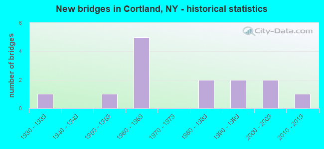
- New bridges - historical statistics
- 11930-1939
- 11950-1959
- 51960-1969
- 21980-1989
- 21990-1999
- 22000-2009
- 12010-2019
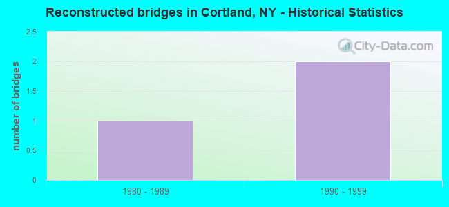
- Reconstructed bridges - Historical Statistics
- 11980-1989
- 21990-1999
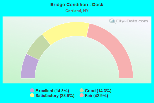
- Bridge Condition - Deck
- 14.3%Excellent
- 14.3%Good
- 28.6%Satisfactory
- 42.9%Fair
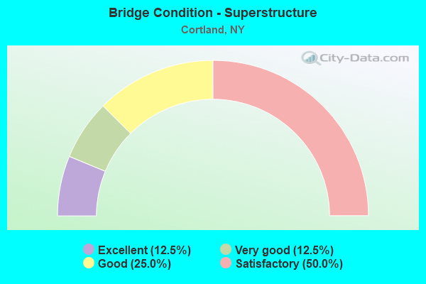
- Bridge Condition - Superstructure
- 12.5%Excellent
- 12.5%Very good
- 25.0%Good
- 50.0%Satisfactory
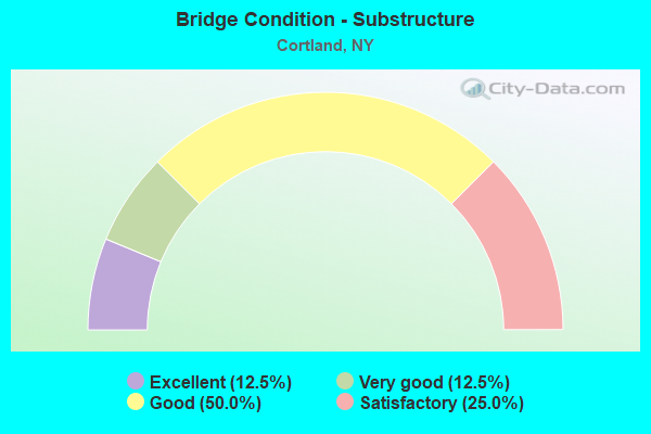
- Bridge Condition - Substructure
- 12.5%Excellent
- 12.5%Very good
- 50.0%Good
- 25.0%Satisfactory
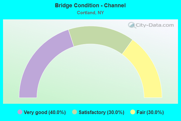
- Bridge Condition - Channel
- 40.0%Very good
- 30.0%Satisfactory
- 30.0%Fair
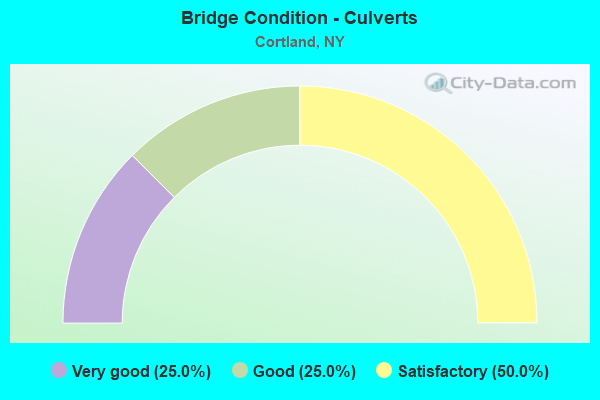
- Bridge Condition - Culverts
- 25.0%Very good
- 25.0%Good
- 50.0%Satisfactory
Find on map >> Show street view
Structure Number: 101042, Location: .1 MI S JCT RTS 13 + I-81 (Lat: 42.607589, Lng: -76.166911), Route carried "on" structure: State highway 13, Year Built: 2008, Status: Open, Structure Length: 3.35m (10.99ft), Average Daily Traffic: 13,873 (year 2020), Truck Traffic: 5%, Average Future Daily Traffic: 16,852 (year 2040), Design Load: HL 93, Features Intersected: TIOUGHNIOGA RIVER
Minimum Vertical Clearance: 30+ m (98+ ft), Kilometerpoint: 11.183, Lanes on structure: 4, Base Highway Network: Yes, Owner: State Highway Agency, Approaching Roadway Width: 18.0m (59.1ft), Skew: 23 degrees, Material/Design: Prestressed concrete, Design/Construction: Box Beam or Girders - Multiple, Number Of Spans In Main Unit: 1, Length of Maximum Span: 32.3m (106.0ft), Curb or Sidewalk Widths: Left: 1.8m (5.9ft), Right: 1.8m (5.9ft), Curb-To-Curb Width: 18.1m (59.4ft), Out-to-Out Width: 22.5m (73.8ft)
Condition: Deck: Satisfactory, Superstructure: Good, Substructure: Very good, Channel: Very good, Operating Rating: 82.0 metric tons, Method Used To Determine Operating Rating: Load Factor (LF), Inventory Rating: 49.0 metric tons, Method Used To Determine Inventory Rating: Load Factor (LF), Structural Evaluation: Better than present minimum criteria, Deck Geometry: Somewhat better than minimum adequacy, Waterway Adequacy: Superior to present desirable criteria, Approach Roadway Alignment: Equal to present desirable criteria, Length Of Structure Improvement: 3.35m (10.99ft), Designated Inspection Frequency: Every 24 months, Inspection Date: May 2020, Bridge Improvement Cost: $2,064,000, Roadway Improvement Cost: $1,209,000, Total Project Cost: $3,273,000 ( Estimate for 2021), Wearing Surface/Protective System: Wearing Surface: Monolithic Concrete
Find on map >> Show street view
Structure Number: 1010431, Location: JCT OF RTS 13 + I-81 SB (Lat: 42.609131, Lng: -76.166458), Route carried "on" structure: Interstate 81, Year Built: 1966, Status: Open, Structure Length: 4.42m (14.50ft), Average Daily Traffic: 13,124 (year 2008), Truck Traffic: 27%, Design Load: HS 20, Features Intersected: RTE 13
Minimum Vertical Clearance: 30+ m (98+ ft), Kilometerpoint: 26.661, Lanes on structure: 2, Lanes under structure: 4, Base Highway Network: Yes, Owner: State Highway Agency, Approaching Roadway Width: 12.2m (40.0ft), Skew: 2 degrees, Material/Design: Steel, Design/Construction: Stringer/Multi-beam, Number Of Spans In Main Unit: 3, Length of Maximum Span: 22.8m (74.8ft), Curb-To-Curb Width: 9.1m (29.9ft), Out-to-Out Width: 10.0m (32.8ft)
Condition: Deck: Satisfactory, Superstructure: Good, Substructure: Good, Operating Rating: 62.6 metric tons, Method Used To Determine Operating Rating: Load Factor (LF), Inventory Rating: 37.2 metric tons, Method Used To Determine Inventory Rating: Load Factor (LF), Structural Evaluation: Better than present minimum criteria, Deck Geometry: High priority of replacement, Underclear: High priority of corrective action, Approach Roadway Alignment: Equal to present desirable criteria, Length Of Structure Improvement: 4.41m (14.47ft), Designated Inspection Frequency: Every 24 months, Inspection Date: April 2021, Bridge Improvement Cost: $919,000, Roadway Improvement Cost: $538,000, Total Project Cost: $1,458,000 ( Estimate for 2021), Deck Structure Type: Concrete Cast-file-Place, Wearing Surface/Protective System: Wearing Surface: Monolithic Concrete
Find on map >> Show street view
Structure Number: 1010432, Location: JCT OF RTS 13 + I-81 NB (Lat: 42.609544, Lng: -76.166275), Route carried "on" structure: Interstate 81, Year Built: 1966, Year Reconstructed: 1995, Status: Open, Structure Length: 4.54m (14.90ft), Average Daily Traffic: 8,055 (year 2019), Truck Traffic: 26%, Average Future Daily Traffic: 11,619 (year 2040), Design Load: HS 20, Features Intersected: RTE 13
Minimum Vertical Clearance: 30+ m (98+ ft), Kilometerpoint: 26.645, Lanes on structure: 2, Lanes under structure: 4, Base Highway Network: Yes, Owner: State Highway Agency, Approaching Roadway Width: 12.2m (40.0ft), Skew: 2 degrees, Material/Design: Steel, Design/Construction: Stringer/Multi-beam, Number Of Spans In Main Unit: 3, Length of Maximum Span: 23.4m (76.8ft), Curb-To-Curb Width: 9.1m (29.9ft), Out-to-Out Width: 10.0m (32.8ft)
Condition: Deck: Fair, Superstructure: Satisfactory, Substructure: Good, Operating Rating: 67.1 metric tons, Method Used To Determine Operating Rating: Load Factor (LF), Inventory Rating: 39.9 metric tons, Method Used To Determine Inventory Rating: Load Factor (LF), Structural Evaluation: Equal to present minimum criteria, Deck Geometry: High priority of replacement, Underclear: High priority of corrective action, Approach Roadway Alignment: Equal to present desirable criteria, Length Of Structure Improvement: 4.54m (14.90ft), Designated Inspection Frequency: Every 24 months, Inspection Date: May 2021, Bridge Improvement Cost: $969,000, Roadway Improvement Cost: $567,000, Total Project Cost: $1,536,000 ( Estimate for 2021), Deck Structure Type: Concrete Cast-file-Place, Wearing Surface/Protective System: Wearing Surface: Monolithic Concrete
Find on map >> Show street view
Structure Number: 101044, Location: 3.6 MI NE JCT SH 13 & I81 (Lat: 42.649319, Lng: -76.123758), Route carried "on" structure: State highway 13, Year Built: 2002, Status: Open, Structure Length: 1.04m (3.41ft), Average Daily Traffic: 2,695 (year 2020), Truck Traffic: 25%, Average Future Daily Traffic: 2,711 (year 2040), Design Load: HS 25 or greater, Features Intersected: TIOUGHNIOGA TRIB
Minimum Vertical Clearance: 30+ m (98+ ft), Kilometerpoint: 17.152, Lanes on structure: 2, Base Highway Network: Yes, Owner: State Highway Agency, Approaching Roadway Width: 10.4m (34.1ft), Skew: 4 degrees, Material/Design: Concrete, Design/Construction: Culvert, Number Of Spans In Main Unit: 1, Length of Maximum Span: 9.5m (31.2ft), Curb-To-Curb Width: 10.3m (33.8ft), Out-to-Out Width: 11.3m (37.1ft)
Condition: Channel: Very good, Culverts: Very good, Operating Rating: 79.3 metric tons, Method Used To Determine Operating Rating: Field evaluation and documented engineering judgment, Inventory Rating: 40.8 metric tons, Method Used To Determine Inventory Rating: Field evaluation and documented engineering judgment, Structural Evaluation: Equal to present desirable criteria, Deck Geometry: Meets minimum limits, Waterway Adequacy: Equal to present minimum criteria, Approach Roadway Alignment: Equal to present desirable criteria, Length Of Structure Improvement: 1.03m (3.38ft), Designated Inspection Frequency: Every 24 months, Inspection Date: September 2020, Bridge Improvement Cost: $768,000, Roadway Improvement Cost: $450,000, Total Project Cost: $1,218,000 ( Estimate for 2021), Wearing Surface/Protective System: Wearing Surface: Bituminous, Membrane: Other
Find on map >> Show street view
Structure Number: 22078, Location: CITY OF CORTLAND (Lat: 42.603722, Lng: -76.193539), Route carried "on" structure: City street , Year Built: 2019, Status: Open, Structure Length: 1.52m (4.99ft), Average Daily Traffic: 1,932 (year 2019), Truck Traffic: 2%, Average Future Daily Traffic: 2,705 (year 2039), Design Load: HS 20, Features Intersected: DRY CREEK, Facility Carried by Structure: MADISON STREET
Minimum Vertical Clearance: 30+ m (98+ ft), Kilometerpoint: 0.547, Lanes on structure: 2, Owner: City or Municipal Highway Agency, Approaching Roadway Width: 8.2m (26.9ft), Skew: 4 degrees, Material/Design: Prestressed concrete, Design/Construction: Box Beam or Girders - Multiple, Number Of Spans In Main Unit: 1, Length of Maximum Span: 14.0m (45.9ft), Curb or Sidewalk Widths: Left: 3.0m (9.8ft), Right: 3.0m (9.8ft), Curb-To-Curb Width: 8.2m (26.9ft), Out-to-Out Width: 15.4m (50.5ft)
Condition: Deck: Excellent, Superstructure: Excellent, Substructure: Excellent, Channel: Very good, Operating Rating: 55.3 metric tons, Method Used To Determine Operating Rating: Load Factor (LF), Inventory Rating: 26.3 metric tons, Method Used To Determine Inventory Rating: Load Factor (LF), Structural Evaluation: Equal to present minimum criteria, Deck Geometry: Meets minimum limits, Waterway Adequacy: Meets minimum limits, Approach Roadway Alignment: Equal to present desirable criteria, Length Of Structure Improvement: 1.52m (4.99ft), Designated Inspection Frequency: Every 24 months, Inspection Date: April 2021, Bridge Improvement Cost: $725,000, Roadway Improvement Cost: $425,000, Total Project Cost: $1,150,000 ( Estimate for 2021), Wearing Surface/Protective System: Wearing Surface: Latex Concrete
Find on map >> Show street view
Structure Number: 220781, Location: CITY OF CORTLAND (Lat: 42.604167, Lng: -76.192900), Route carried "on" structure: City street , Year Built: 1935, Year Reconstructed: 1998, Status: Open, Structure Length: 0.88m (2.89ft), Average Daily Traffic: 954 (year 2020), Truck Traffic: 2%, Average Future Daily Traffic: 1,180 (year 2040), Design Load: HS 25 or greater, Features Intersected: DRY CREEK, Facility Carried by Structure: FLORAL AVE
Minimum Vertical Clearance: 30+ m (98+ ft), Kilometerpoint: 0.354, Lanes on structure: 2, Owner: City or Municipal Highway Agency, Approaching Roadway Width: 7.3m (24.0ft), Skew: 3 degrees, Material/Design: Prestressed concrete, Design/Construction: Box Beam or Girders - Multiple, Number Of Spans In Main Unit: 1, Length of Maximum Span: 8.2m (26.9ft), Curb or Sidewalk Widths: Left: 4.0m (13.1ft), Right: 3.7m (12.1ft), Curb-To-Curb Width: 7.3m (24.0ft), Out-to-Out Width: 15.0m (49.2ft)
Condition: Superstructure: Very good, Substructure: Good, Channel: Very good, Operating Rating: 69.9 metric tons, Method Used To Determine Operating Rating: Load Factor (LF), Inventory Rating: 41.7 metric tons, Method Used To Determine Inventory Rating: Load Factor (LF), Structural Evaluation: Better than present minimum criteria, Deck Geometry: Meets minimum limits, Waterway Adequacy: Somewhat better than minimum adequacy, Approach Roadway Alignment: Equal to present desirable criteria, Length Of Structure Improvement: 0.88m (2.89ft), Designated Inspection Frequency: Every 24 months, Inspection Date: May 2020, Bridge Improvement Cost: $423,000, Roadway Improvement Cost: $248,000, Total Project Cost: $670,000 ( Estimate for 2021), Wearing Surface/Protective System: Wearing Surface: Monolithic Concrete
Find on map >> Show street view
Structure Number: 220782, Location: 1 MI W RTE 11 (Lat: 42.604728, Lng: -76.191708), Route carried "on" structure: City street , Year Built: 1999, Status: Open, Structure Length: 0.94m (3.08ft), Average Daily Traffic: 817 (year 2018), Truck Traffic: 1%, Average Future Daily Traffic: 1,144 (year 2038), Design Load: HS 20, Features Intersected: DRY CREEK, Facility Carried by Structure: HAMLIN STREET
Minimum Vertical Clearance: 30+ m (98+ ft), Kilometerpoint: 0.370, Lanes on structure: 2, Owner: City or Municipal Highway Agency, Approaching Roadway Width: 7.6m (24.9ft), Skew: 2 degrees, Material/Design: Concrete, Design/Construction: Culvert, Number Of Spans In Main Unit: 2, Length of Maximum Span: 4.5m (14.8ft), Curb or Sidewalk Widths: Left: 5.0m (16.4ft), Right: 4.9m (16.1ft), Curb-To-Curb Width: 7.6m (24.9ft), Out-to-Out Width: 18.6m (61.0ft)
Condition: Channel: Satisfactory, Culverts: Good, Operating Rating: 75.8 metric tons, Method Used To Determine Operating Rating: Field evaluation and documented engineering judgment, Inventory Rating: 32.7 metric tons, Method Used To Determine Inventory Rating: Field evaluation and documented engineering judgment, Structural Evaluation: Better than present minimum criteria, Deck Geometry: Meets minimum limits, Waterway Adequacy: Somewhat better than minimum adequacy, Approach Roadway Alignment: Equal to present desirable criteria, Length Of Structure Improvement: 0.94m (3.08ft), Designated Inspection Frequency: Every 24 months, Inspection Date: May 2021, Bridge Improvement Cost: $407,000, Roadway Improvement Cost: $238,000, Total Project Cost: $645,000 ( Estimate for 2021)
Find on map >> Show street view
Structure Number: 220783, Location: CITY OF CORTLAND (Lat: 42.606917, Lng: -76.185936), Route carried "on" structure: City street , Year Built: 1980, Status: Open, Structure Length: 1.07m (3.51ft), Average Daily Traffic: 2,599 (year 2020), Truck Traffic: 3%, Average Future Daily Traffic: 3,157 (year 2040), Features Intersected: DRY CREEK, Facility Carried by Structure: HOMER AVE
Minimum Vertical Clearance: 30+ m (98+ ft), Kilometerpoint: 0.660, Lanes on structure: 2, Owner: City or Municipal Highway Agency, Approaching Roadway Width: 9.4m (30.8ft), Skew: 3 degrees, Material/Design: Concrete, Design/Construction: Culvert, Number Of Spans In Main Unit: 1, Length of Maximum Span: 10.3m (33.8ft), Curb or Sidewalk Widths: Left: 1.5m (4.9ft), Right: 1.5m (4.9ft), Curb-To-Curb Width: 9.4m (30.8ft), Out-to-Out Width: 61.0m (200.1ft)
Condition: Channel: Fair, Culverts: Satisfactory, Operating Rating: 76.9 metric tons, Method Used To Determine Operating Rating: Field evaluation and documented engineering judgment, Inventory Rating: 19.6 metric tons, Method Used To Determine Inventory Rating: Field evaluation and documented engineering judgment, Structural Evaluation: Somewhat better than minimum adequacy, Deck Geometry: Meets minimum limits, Waterway Adequacy: Meets minimum limits, Approach Roadway Alignment: Equal to present desirable criteria, Length Of Structure Improvement: 1.06m (3.48ft), Designated Inspection Frequency: Every 24 months, Inspection Date: May 2021, Bridge Improvement Cost: $1,506,000, Roadway Improvement Cost: $882,000, Total Project Cost: $2,389,000 ( Estimate for 2021)
Find on map >> Show street view
Structure Number: 220785, Location: 0.6 MI N JCT RTS 11 & 222 (Lat: 42.607817, Lng: -76.184825), Route carried "on" structure: US 11, Year Built: 1991, Status: Open, Structure Length: 0.88m (2.89ft), Average Daily Traffic: 5,589 (year 2018), Truck Traffic: 5%, Average Future Daily Traffic: 6,789 (year 2040), Design Load: HS 20, Features Intersected: DRY CREEK
Minimum Vertical Clearance: 30+ m (98+ ft), Kilometerpoint: 28.351, Lanes on structure: 2, Base Highway Network: Yes, Owner: City or Municipal Highway Agency, Approaching Roadway Width: 11.6m (38.1ft), Material/Design: Prestressed concrete, Design/Construction: Box Beam or Girders - Multiple, Number Of Spans In Main Unit: 1, Length of Maximum Span: 7.3m (24.0ft), Curb or Sidewalk Widths: Left: 2.7m (8.9ft), Right: 2.7m (8.9ft), Curb-To-Curb Width: 11.6m (38.1ft), Out-to-Out Width: 17.8m (58.4ft)
Condition: Deck: Fair, Superstructure: Satisfactory, Substructure: Good, Channel: Fair, Operating Rating: 89.8 metric tons, Method Used To Determine Operating Rating: Load Factor (LF), Inventory Rating: 47.2 metric tons, Method Used To Determine Inventory Rating: Load Factor (LF), Structural Evaluation: Equal to present minimum criteria, Deck Geometry: Somewhat better than minimum adequacy, Waterway Adequacy: Somewhat better than minimum adequacy, Approach Roadway Alignment: Equal to present desirable criteria, Length Of Structure Improvement: 0.88m (2.89ft), Designated Inspection Frequency: Every 24 months, Inspection Date: May 2021, Bridge Improvement Cost: $687,000, Roadway Improvement Cost: $402,000, Total Project Cost: $1,090,000 ( Estimate for 2021), Deck Structure Type: Concrete Cast-file-Place, Wearing Surface/Protective System: Wearing Surface: Integral Concrete
Find on map >> Show street view
Structure Number: 220786, Location: 0.4 MI W JCT RTS 222 + 11 (Lat: 42.601031, Lng: -76.189339), Route carried "on" structure: State highway 222, Year Built: 1983, Status: Open, Structure Length: 0.91m (2.99ft), Average Daily Traffic: 6,185 (year 2020), Truck Traffic: 5%, Average Future Daily Traffic: 7,513 (year 2040), Design Load: HS 20, Features Intersected: OTTER CREEK
Minimum Vertical Clearance: 30+ m (98+ ft), Kilometerpoint: 6.613, Lanes on structure: 2, Base Highway Network: Yes, Owner: City or Municipal Highway Agency, Approaching Roadway Width: 9.1m (29.9ft), Skew: 4 degrees, Material/Design: Concrete, Design/Construction: Culvert, Number Of Spans In Main Unit: 1, Length of Maximum Span: 8.8m (28.9ft), Curb or Sidewalk Widths: Left: 5.8m (19.0ft), Right: 3.7m (12.1ft), Curb-To-Curb Width: 10.2m (33.5ft), Out-to-Out Width: 21.6m (70.9ft)
Condition: Channel: Fair, Culverts: Satisfactory, Operating Rating: 78.8 metric tons, Method Used To Determine Operating Rating: Field evaluation and documented engineering judgment, Inventory Rating: 32.7 metric tons, Method Used To Determine Inventory Rating: Field evaluation and documented engineering judgment, Structural Evaluation: Equal to present minimum criteria, Deck Geometry: Meets minimum limits, Waterway Adequacy: Meets minimum limits, Approach Roadway Alignment: Equal to present desirable criteria, Length Of Structure Improvement: 0.91m (2.99ft), Designated Inspection Frequency: Every 24 months, Inspection Date: November 2021, Bridge Improvement Cost: $732,000, Roadway Improvement Cost: $429,000, Total Project Cost: $1,161,000 ( Estimate for 2021)
Find on map >> Show street view
Structure Number: 220787, Location: CITY OF CORTLAND (Lat: 42.604308, Lng: -76.185722), Route carried "on" structure: City street , Year Built: 1954, Year Reconstructed: 1980, Status: Open, Structure Length: 0.70m (2.30ft), Average Daily Traffic: 2,325 (year 2017), Truck Traffic: 2%, Average Future Daily Traffic: 3,255 (year 2037), Features Intersected: OTTER CREEK, Facility Carried by Structure: MADISON STREET
Minimum Vertical Clearance: 30+ m (98+ ft), Kilometerpoint: 1.191, Lanes on structure: 2, Owner: City or Municipal Highway Agency, Approaching Roadway Width: 7.9m (25.9ft), Skew: 4 degrees, Material/Design: Steel, Design/Construction: Stringer/Multi-beam, Number Of Spans In Main Unit: 1, Length of Maximum Span: 6.4m (21.0ft), Curb or Sidewalk Widths: Left: 2.9m (9.5ft), Right: 3.0m (9.8ft), Curb-To-Curb Width: 9.1m (29.9ft), Out-to-Out Width: 15.2m (49.9ft)
Condition: Deck: Fair, Superstructure: Satisfactory, Substructure: Satisfactory, Channel: Satisfactory, Operating Rating: 74.3 metric tons, Method Used To Determine Operating Rating: Field evaluation and documented engineering judgment, Inventory Rating: 32.7 metric tons, Method Used To Determine Inventory Rating: Field evaluation and documented engineering judgment, Structural Evaluation: Equal to present minimum criteria, Deck Geometry: Meets minimum limits, Waterway Adequacy: Meets minimum limits, Approach Roadway Alignment: Equal to present desirable criteria, Length Of Structure Improvement: 0.70m (2.30ft), Designated Inspection Frequency: Every 24 months, Inspection Date: April 2021, Bridge Improvement Cost: $237,000, Roadway Improvement Cost: $139,000, Total Project Cost: $376,000 ( Estimate for 2021), Deck Structure Type: Open Grating, Wearing Surface/Protective System: Wearing Surface: Other
Find on map >> Show street view
Structure Number: 220788, Location: CITY OF CORTLAND (Lat: 42.606133, Lng: -76.174831), Route carried "on" structure: City street , Year Built: 1962, Status: Open, Structure Length: 2.10m (6.89ft), Average Daily Traffic: 2,255 (year 2017), Truck Traffic: 4%, Average Future Daily Traffic: 3,157 (year 2037), Design Load: H 15, Features Intersected: W B TIOUGHNIOGA R, Facility Carried by Structure: RICKARD STREET
Minimum Vertical Clearance: 30+ m (98+ ft), Kilometerpoint: 0.209, Lanes on structure: 2, Owner: City or Municipal Highway Agency, Approaching Roadway Width: 8.2m (26.9ft), Skew: 2 degrees, Material/Design: Steel, Design/Construction: Stringer/Multi-beam, Number Of Spans In Main Unit: 1, Length of Maximum Span: 20.1m (65.9ft), Curb or Sidewalk Widths: Left: 1.2m (3.9ft), Right: 0.0m, Curb-To-Curb Width: 8.6m (28.2ft), Out-to-Out Width: 10.8m (35.4ft)
Condition: Deck: Good, Superstructure: Satisfactory, Substructure: Satisfactory, Channel: Satisfactory, Operating Rating: 80.7 metric tons, Method Used To Determine Operating Rating: Load Factor (LF), Inventory Rating: 48.1 metric tons, Method Used To Determine Inventory Rating: Load Factor (LF), Structural Evaluation: Equal to present minimum criteria, Deck Geometry: Meets minimum limits, Waterway Adequacy: Somewhat better than minimum adequacy, Approach Roadway Alignment: Equal to present minimum criteria, Length Of Structure Improvement: 2.10m (6.89ft), Designated Inspection Frequency: Every 24 months, Inspection Date: May 2021, Bridge Improvement Cost: $738,000, Roadway Improvement Cost: $432,000, Total Project Cost: $1,170,000 ( Estimate for 2021), Deck Structure Type: Concrete Cast-file-Place, Wearing Surface/Protective System: Wearing Surface: Bituminous, Deck Protection: Epoxy Coated Reinforcing
Find on map >> Show street view
Structure Number: 1010431, Location: JCT OF RTS 13 + I-81 SB (Lat: 42.609131, Lng: -76.166458), Route carried "under" structure: State highway 13, Year Built: 1966, Structure Length: 0. m, Average Daily Traffic: 16,277 (year 2000), Features Intersected: RTE 13, Facility Carried by Structure: RTE I81
Minimum Vertical Clearance: 4.87m (15.98ft), Kilometerpoint: 3.781, Lanes on structure: 2, Lanes under structure: 4, Material/Design: Steel, Design/Construction: Stringer/Multi-beam, Length of Maximum Span: 22.8m (74.8ft)
Find on map >> Show street view
Structure Number: 1010432, Location: JCT OF RTS 13 + I-81 NB (Lat: 42.609544, Lng: -76.166275), Route carried "under" structure: State highway 13, Year Built: 1966, Structure Length: 0. m, Average Daily Traffic: 16,277 (year 2000), Features Intersected: RTE 13, Facility Carried by Structure: RTE I81
Minimum Vertical Clearance: 4.90m (16.08ft), Kilometerpoint: 3.781, Lanes on structure: 2, Lanes under structure: 4, Material/Design: Steel, Design/Construction: Stringer/Multi-beam, Length of Maximum Span: 23.4m (76.8ft)