Bridge Statistics for Cottondale, Florida (FL)
Condition, Traffic, Stress, Structural Evaluation, Project Costs
- National Bridge Inventory (NBI) Statistics
- 16Number of bridges
- 105ft / 32.1mTotal length
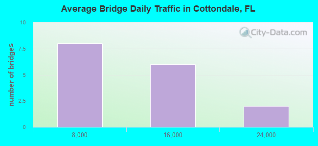
- 107,201Total average daily traffic
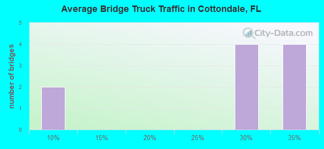
- 30,149Total average daily truck traffic
- National Bridge Inventory (NBI) Registered Bridges for Cottondale
- No street view available for this location
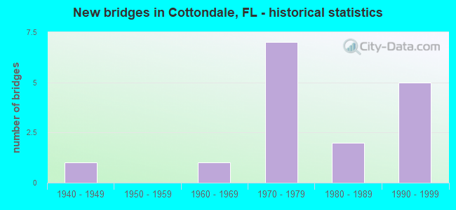
- New bridges - historical statistics
- 11940-1949
- 11960-1969
- 71970-1979
- 21980-1989
- 51990-1999
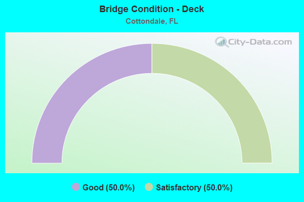
- Bridge Condition - Deck
- 50.0%Good
- 50.0%Satisfactory
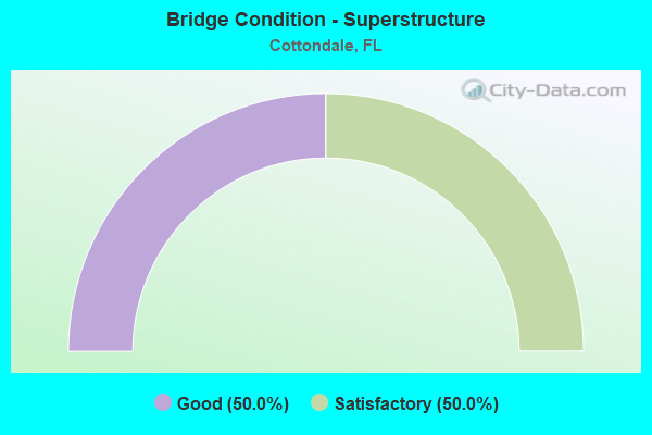
- Bridge Condition - Superstructure
- 50.0%Good
- 50.0%Satisfactory
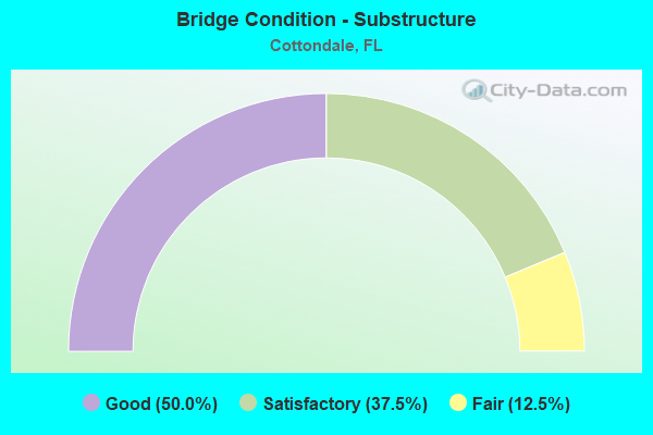
- Bridge Condition - Substructure
- 50.0%Good
- 37.5%Satisfactory
- 12.5%Fair
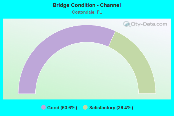
- Bridge Condition - Channel
- 63.6%Good
- 36.4%Satisfactory
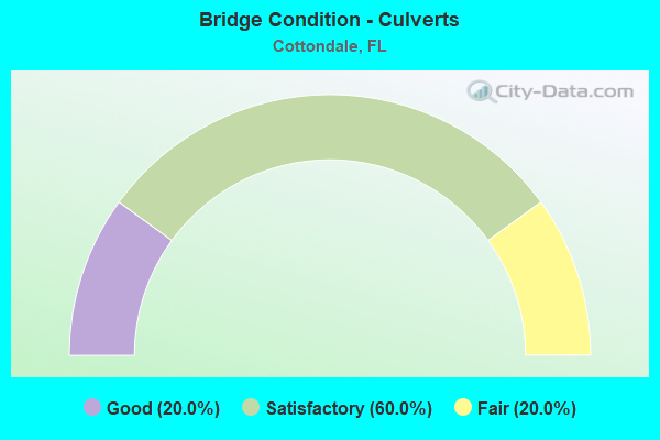
- Bridge Condition - Culverts
- 20.0%Good
- 60.0%Satisfactory
- 20.0%Fair
Find on map >> Show street view
Structure Number: 530007, Location: 4.9mi. North of US90 SR10 (Lat: 30.854083, Lng: -85.351250), Route carried "on" structure: US 231, Year Built: 1973, Status: Open, Structure Length: 0.81m (2.66ft), Average Daily Traffic: 11,600 (year 2020), Truck Traffic: 28%, Average Future Daily Traffic: 20,126 (year 2042), Design Load: HS 20+Mod, Features Intersected: Russ Mill Creek
Minimum Vertical Clearance: 30+ m (98+ ft), Kilometerpoint: 12.120, Lanes on structure: 4, Base Highway Network: Yes, Owner: State Highway Agency, Approaching Roadway Width: 17.7m (58.1ft), Skew: 9 degrees, Material/Design: Concrete, Design/Construction: Culvert, Number Of Spans In Main Unit: 3, Length of Maximum Span: 2.4m (7.9ft)
Condition: Channel: Satisfactory, Culverts: Satisfactory, Operating Rating: 48.1 metric tons, Method Used To Determine Operating Rating: Load Factor (LF), Inventory Rating: 28.1 metric tons, Method Used To Determine Inventory Rating: Load Factor (LF), Structural Evaluation: Equal to present minimum criteria, Waterway Adequacy: Better than present minimum criteria, Approach Roadway Alignment: Equal to present desirable criteria, Designated Inspection Frequency: Every 24 months, Inspection Date: June 2021
Find on map >> Show street view
Structure Number: 530068, Location: 1.6 Mi. S. of US90 SR10 (Lat: 30.753097, Lng: -85.381900), Route carried "on" structure: Interstate 10, Year Built: 1976, Status: Open, Structure Length: 11.37m (37.30ft), Average Daily Traffic: 8,403 (year 2020), Truck Traffic: 33%, Average Future Daily Traffic: 14,579 (year 2042), Design Load: HS 20, Features Intersected: US231 SR75 : Bayline RR
Minimum Vertical Clearance: 30+ m (98+ ft), Kilometerpoint: 4.833, Lanes on structure: 3, Lanes under structure: 5, Base Highway Network: Yes, Owner: State Highway Agency, Approaching Roadway Width: 11.6m (38.1ft), Skew: 3 degrees, Material/Design: Prestressed concrete, Design/Construction: Stringer/Multi-beam, Number Of Spans In Main Unit: 5, Length of Maximum Span: 26.8m (87.9ft), Curb-To-Curb Width: 14.6m (47.9ft), Out-to-Out Width: 15.3m (50.2ft)
Condition: Deck: Good, Superstructure: Good, Substructure: Good, Operating Rating: 74.9 metric tons, Method Used To Determine Operating Rating: Load Factor (LF), Inventory Rating: 44.9 metric tons, Method Used To Determine Inventory Rating: Load Factor (LF), Structural Evaluation: Better than present minimum criteria, Deck Geometry: Meets minimum limits, Underclear: Equal to present minimum criteria, Approach Roadway Alignment: Equal to present desirable criteria, Designated Inspection Frequency: Every 24 months, Inspection Date: November 2021, Deck Structure Type: Concrete Cast-file-Place
Find on map >> Show street view
Structure Number: 530069, Location: 1.7 Mi S. of US90 SR10 (Lat: 30.752822, Lng: -85.382014), Route carried "on" structure: Interstate 10, Year Built: 1976, Status: Open, Structure Length: 11.37m (37.30ft), Average Daily Traffic: 8,403 (year 2020), Truck Traffic: 33%, Average Future Daily Traffic: 14,579 (year 2042), Design Load: HS 20, Features Intersected: US231 SR75 : Bayline RR
Minimum Vertical Clearance: 30+ m (98+ ft), Kilometerpoint: 4.833, Lanes on structure: 3, Lanes under structure: 5, Base Highway Network: Yes, Owner: State Highway Agency, Approaching Roadway Width: 11.6m (38.1ft), Skew: 3 degrees, Material/Design: Prestressed concrete, Design/Construction: Stringer/Multi-beam, Number Of Spans In Main Unit: 5, Length of Maximum Span: 26.8m (87.9ft), Curb-To-Curb Width: 14.6m (47.9ft), Out-to-Out Width: 15.5m (50.9ft)
Condition: Deck: Good, Superstructure: Good, Substructure: Good, Operating Rating: 74.9 metric tons, Method Used To Determine Operating Rating: Load Factor (LF), Inventory Rating: 44.9 metric tons, Method Used To Determine Inventory Rating: Load Factor (LF), Structural Evaluation: Better than present minimum criteria, Deck Geometry: Meets minimum limits, Underclear: Equal to present minimum criteria, Approach Roadway Alignment: Equal to present desirable criteria, Designated Inspection Frequency: Every 24 months, Inspection Date: November 2021, Deck Structure Type: Concrete Cast-file-Place
Find on map >> Show street view
Structure Number: 530071, Location: 0.1 Mi E. of US231 SR75 (Lat: 30.753694, Lng: -85.376083), Route carried "on" structure: Interstate 10, Year Built: 1976, Status: Open, Structure Length: 1.05m (3.44ft), Average Daily Traffic: 21,607 (year 2020), Truck Traffic: 30%, Average Future Daily Traffic: 37,488 (year 2042), Design Load: HS 20, Features Intersected: Stream
Minimum Vertical Clearance: 30+ m (98+ ft), Kilometerpoint: 5.443, Lanes on structure: 6, Base Highway Network: Yes, Owner: State Highway Agency, Approaching Roadway Width: 23.2m (76.1ft), Skew: 10 degrees, Material/Design: Concrete, Design/Construction: Culvert, Number Of Spans In Main Unit: 3, Length of Maximum Span: 3.4m (11.2ft)
Condition: Channel: Good, Culverts: Fair, Inventory Rating: 74.0 metric tons, Method Used To Determine Inventory Rating: Load Factor (LF), Structural Evaluation: Somewhat better than minimum adequacy, Waterway Adequacy: Better than present minimum criteria, Approach Roadway Alignment: Equal to present desirable criteria, Designated Inspection Frequency: Every 24 months, Underwater Inspection Frequency: Every 24 months, Inspection Date: September 2021, Underwater Inspection Date: September 2021
Find on map >> Show street view
Structure Number: 530072, Location: 2.4 Miles East of US231 (Lat: 30.757278, Lng: -85.336444), Route carried "on" structure: Interstate 10, Year Built: 1976, Status: Open, Structure Length: 0.86m (2.82ft), Average Daily Traffic: 21,607 (year 2020), Truck Traffic: 30%, Average Future Daily Traffic: 37,488 (year 2042), Design Load: HS 20, Features Intersected: Unnamed Creek
Minimum Vertical Clearance: 30+ m (98+ ft), Kilometerpoint: 9.281, Lanes on structure: 4, Base Highway Network: Yes, Owner: State Highway Agency, Approaching Roadway Width: 23.2m (76.1ft), Skew: 10 degrees, Material/Design: Concrete, Design/Construction: Culvert, Number Of Spans In Main Unit: 3, Length of Maximum Span: 2.7m (8.9ft)
Condition: Channel: Good, Culverts: Satisfactory, Structural Evaluation: Equal to present minimum criteria, Waterway Adequacy: Better than present minimum criteria, Approach Roadway Alignment: Equal to present desirable criteria, Designated Inspection Frequency: Every 24 months, Inspection Date: September 2021
Find on map >> Show street view
Structure Number: 530101, Location: 1.1mile E. of County Line (Lat: 30.787417, Lng: -85.437306), Route carried "on" structure: US 90, Year Built: 1969, Year Reconstructed: 2002, Status: Open, Structure Length: 0.70m (2.30ft), Average Daily Traffic: 3,500 (year 2020), Truck Traffic: 9%, Average Future Daily Traffic: 6,072 (year 2042), Design Load: HS 20+Mod, Features Intersected: Unamed Branch
Minimum Vertical Clearance: 30+ m (98+ ft), Kilometerpoint: 1.851, Lanes on structure: 2, Base Highway Network: Yes, Owner: State Highway Agency, Approaching Roadway Width: 10.4m (34.1ft), Material/Design: Concrete, Design/Construction: Culvert, Number Of Spans In Main Unit: 2, Length of Maximum Span: 3.4m (11.2ft)
Condition: Channel: Good, Culverts: Good, Operating Rating: 38.1 metric tons, Method Used To Determine Operating Rating: Load and Resistance Factor (LRFR), Inventory Rating: 24.5 metric tons, Method Used To Determine Inventory Rating: Load and Resistance Factor (LRFR), Structural Evaluation: Equal to present minimum criteria, Waterway Adequacy: Equal to present desirable criteria, Approach Roadway Alignment: Equal to present desirable criteria, Designated Inspection Frequency: Every 24 months, Inspection Date: July 2021
Find on map >> Show street view
Structure Number: 530102, Location: 0.5MI N. of I10 SR8 (Lat: 30.762444, Lng: -85.377556), Route carried "on" structure: US 231, Year Built: 1982, Status: Open, Structure Length: 0.69m (2.26ft), Average Daily Traffic: 9,300 (year 2020), Truck Traffic: 28%, Average Future Daily Traffic: 16,136 (year 2042), Design Load: HS 20, Features Intersected: Stream
Minimum Vertical Clearance: 30+ m (98+ ft), Kilometerpoint: 22.698, Lanes on structure: 5, Base Highway Network: Yes, Owner: State Highway Agency, Approaching Roadway Width: 23.2m (76.1ft), Skew: 10 degrees, Material/Design: Concrete, Design/Construction: Culvert, Number Of Spans In Main Unit: 2, Length of Maximum Span: 3.4m (11.2ft)
Condition: Channel: Good, Culverts: Satisfactory, Operating Rating: 62.0 metric tons, Method Used To Determine Operating Rating: Load Factor (LF), Inventory Rating: 37.4 metric tons, Method Used To Determine Inventory Rating: Load Factor (LF), Structural Evaluation: Equal to present minimum criteria, Waterway Adequacy: Equal to present desirable criteria, Approach Roadway Alignment: Equal to present desirable criteria, Designated Inspection Frequency: Every 24 months, Underwater Inspection Frequency: Every 24 months, Inspection Date: September 2021, Underwater Inspection Date: September 2021
Find on map >> Show street view
Structure Number: 534002, Location: 1.16 Miles East of SR 73 (Lat: 30.852311, Lng: -85.341506), Route carried "on" structure: Other road , Year Built: 1991, Status: Posted for load, Structure Length: 0.78m (2.56ft), Average Daily Traffic: 60 (year 2019), Average Future Daily Traffic: 66 (year 2039), Features Intersected: Russ Mill Creek, Facility Carried by Structure: Union Road
Minimum Vertical Clearance: 30+ m (98+ ft), Kilometerpoint: 1.872, Lanes on structure: 1, Owner: County Highway Agency, Approaching Roadway Width: 4.9m (16.1ft), Material/Design: Wood or Timber, Design/Construction: Stringer/Multi-beam, Number Of Spans In Main Unit: 2, Length of Maximum Span: 4.0m (13.1ft), Curb or Sidewalk Widths: Left: 0.1m (0.3ft), Right: 0.1m (0.3ft), Curb-To-Curb Width: 5.8m (19.0ft), Out-to-Out Width: 6.1m (20.0ft)
Condition: Deck: Satisfactory, Superstructure: Satisfactory, Substructure: Satisfactory, Channel: Satisfactory, Operating Rating: 9.1 metric tons, Method Used To Determine Operating Rating: Load and Resistance Factor (LRFR), Inventory Rating: 7.3 metric tons, Method Used To Determine Inventory Rating: Load and Resistance Factor (LRFR), Structural Evaluation: High priority of corrective action, Deck Geometry: Meets minimum limits, Waterway Adequacy: Better than present minimum criteria, Approach Roadway Alignment: Equal to present desirable criteria, Bridge Posting: Required (Relationship of Operating Rating to Maximum Legal Load: 30.0 - 39.9% below), Designated Inspection Frequency: Every 24 months, Other Special Inspection Frequency: Every 12 months, Inspection Date: March 2020, Other Special Inspection Date: March 2021, Deck Structure Type: Wood or Timber, Wearing Surface/Protective System: Wearing Surface: Wood or Timber
Find on map >> Show street view
Structure Number: 534011, Location: 1.66 Miles No. US90/SR10 (Lat: 30.809747, Lng: -85.438814), Route carried "on" structure: Other road , Year Built: 1991, Status: Posted for load, Structure Length: 0.75m (2.46ft), Average Daily Traffic: 48 (year 2020), Average Future Daily Traffic: 53 (year 2040), Design Load: HL 93, Features Intersected: Unnamed Branch, Facility Carried by Structure: Palmview Road
Minimum Vertical Clearance: 30+ m (98+ ft), Kilometerpoint: 2.210, Lanes on structure: 1, Owner: County Highway Agency, Approaching Roadway Width: 4.6m (15.1ft), Material/Design: Wood or Timber, Design/Construction: Stringer/Multi-beam, Number Of Spans In Main Unit: 2, Length of Maximum Span: 3.8m (12.5ft), Curb or Sidewalk Widths: Left: 0.2m (0.7ft), Right: 0.2m (0.7ft), Curb-To-Curb Width: 5.7m (18.7ft), Out-to-Out Width: 6.1m (20.0ft)
Condition: Deck: Good, Superstructure: Satisfactory, Substructure: Satisfactory, Channel: Good, Operating Rating: 7.3 metric tons, Method Used To Determine Operating Rating: Load and Resistance Factor (LRFR), Inventory Rating: 5.4 metric tons, Method Used To Determine Inventory Rating: Load and Resistance Factor (LRFR), Structural Evaluation: High priority of corrective action, Deck Geometry: Meets minimum limits, Waterway Adequacy: Better than present minimum criteria, Approach Roadway Alignment: Equal to present desirable criteria, Bridge Posting: Required (Relationship of Operating Rating to Maximum Legal Load: > 39.9% below), Designated Inspection Frequency: Every 24 months, Other Special Inspection Frequency: Every 12 months, Inspection Date: June 2020, Other Special Inspection Date: June 2021, Deck Structure Type: Wood or Timber, Wearing Surface/Protective System: Wearing Surface: Wood or Timber
Find on map >> Show street view
Structure Number: 534012, Location: 1.8 Mi North of US90/SR10 (Lat: 30.810958, Lng: -85.439544), Route carried "on" structure: Other road , Year Built: 1991, Status: Open, Structure Length: 1.47m (4.82ft), Average Daily Traffic: 48 (year 2019), Average Future Daily Traffic: 53 (year 2039), Design Load: HL 93, Features Intersected: Unnamed Branch, Facility Carried by Structure: Aycock Road
Minimum Vertical Clearance: 30+ m (98+ ft), Kilometerpoint: 2.750, Lanes on structure: 1, Owner: County Highway Agency, Approaching Roadway Width: 4.6m (15.1ft), Material/Design: Wood or Timber, Design/Construction: Stringer/Multi-beam, Number Of Spans In Main Unit: 4, Length of Maximum Span: 3.9m (12.8ft), Curb or Sidewalk Widths: Left: 0.2m (0.7ft), Right: 0.2m (0.7ft), Curb-To-Curb Width: 5.8m (19.0ft), Out-to-Out Width: 6.1m (20.0ft)
Condition: Deck: Satisfactory, Superstructure: Satisfactory, Substructure: Good, Channel: Satisfactory, Operating Rating: 25.4 metric tons, Method Used To Determine Operating Rating: Load and Resistance Factor (LRFR), Inventory Rating: 20.0 metric tons, Method Used To Determine Inventory Rating: Load and Resistance Factor (LRFR), Structural Evaluation: Somewhat better than minimum adequacy, Deck Geometry: Meets minimum limits, Waterway Adequacy: Better than present minimum criteria, Approach Roadway Alignment: Equal to present desirable criteria, Designated Inspection Frequency: Every 24 months, Inspection Date: May 2020, Deck Structure Type: Wood or Timber, Wearing Surface/Protective System: Wearing Surface: Wood or Timber
Find on map >> Show street view
Structure Number: 534023, Location: 0.15 Miles East U231/SR75 (Lat: 30.748228, Lng: -85.381297), Route carried "on" structure: Other road , Year Built: 1992, Status: Open, Structure Length: 0.73m (2.40ft), Average Daily Traffic: 55 (year 2020), Average Future Daily Traffic: 60 (year 2040), Features Intersected: Reedy Creek Relief, Facility Carried by Structure: Dilmore Road
Minimum Vertical Clearance: 30+ m (98+ ft), Kilometerpoint: 0.248, Lanes on structure: 2, Owner: County Highway Agency, Approaching Roadway Width: 6.1m (20.0ft), Material/Design: Concrete, Design/Construction: Channel Beam, Number Of Spans In Main Unit: 1, Length of Maximum Span: 7.3m (24.0ft), Curb-To-Curb Width: 8.6m (28.2ft), Out-to-Out Width: 8.6m (28.2ft)
Condition: Deck: Good, Superstructure: Good, Substructure: Satisfactory, Channel: Good, Inventory Rating: 56.2 metric tons, Method Used To Determine Inventory Rating: Allowable Stress (AS), Structural Evaluation: Equal to present minimum criteria, Deck Geometry: Better than present minimum criteria, Waterway Adequacy: Better than present minimum criteria, Approach Roadway Alignment: Equal to present desirable criteria, Designated Inspection Frequency: Every 24 months, Inspection Date: May 2021, Deck Structure Type: Concrete Precast Panels
Find on map >> Show street view
Structure Number: 534193, Location: 0.4 Mi South of US90/SR10 (Lat: 30.780167, Lng: -85.309111), Route carried "on" structure: County highway , Year Built: 1993, Status: Open, Structure Length: 0.75m (2.46ft), Average Daily Traffic: 50 (year 2018), Average Future Daily Traffic: 60 (year 2038), Design Load: HL 93, Features Intersected: Unnamed Branch, Facility Carried by Structure: Maridale Road
Minimum Vertical Clearance: 30+ m (98+ ft), Kilometerpoint: 0.000, Lanes on structure: 1, Owner: County Highway Agency, Approaching Roadway Width: 4.6m (15.1ft), Material/Design: Wood or Timber, Design/Construction: Stringer/Multi-beam, Number Of Spans In Main Unit: 2, Length of Maximum Span: 4.1m (13.5ft), Curb or Sidewalk Widths: Left: 0.2m (0.7ft), Right: 0.2m (0.7ft), Curb-To-Curb Width: 5.9m (19.4ft), Out-to-Out Width: 6.2m (20.3ft)
Condition: Deck: Satisfactory, Superstructure: Good, Substructure: Good, Channel: Satisfactory, Operating Rating: 41.7 metric tons, Method Used To Determine Operating Rating: Load and Resistance Factor (LRFR), Inventory Rating: 31.8 metric tons, Method Used To Determine Inventory Rating: Load and Resistance Factor (LRFR), Structural Evaluation: Better than present minimum criteria, Deck Geometry: Meets minimum limits, Waterway Adequacy: Better than present minimum criteria, Approach Roadway Alignment: Equal to present desirable criteria, Designated Inspection Frequency: Every 24 months, Inspection Date: Febuary 2022, Deck Structure Type: Wood or Timber, Wearing Surface/Protective System: Wearing Surface: Wood or Timber
Find on map >> Show street view
Structure Number: 534194, Location: 0.4 Mi East of US231/SR75 (Lat: 30.801361, Lng: -85.370528), Route carried "on" structure: City street , Year Built: 1980, Status: Open, Structure Length: 0.77m (2.53ft), Average Daily Traffic: 120 (year 2020), Average Future Daily Traffic: 132 (year 2040), Features Intersected: Unnamed Branch, Facility Carried by Structure: Broad Street
Minimum Vertical Clearance: 30+ m (98+ ft), Kilometerpoint: 0.000, Lanes on structure: 1, Owner: City or Municipal Highway Agency, Approaching Roadway Width: 4.0m (13.1ft), Material/Design: Wood or Timber, Design/Construction: Stringer/Multi-beam, Number Of Spans In Main Unit: 2, Length of Maximum Span: 3.8m (12.5ft), Curb or Sidewalk Widths: Left: 0.2m (0.7ft), Right: 0.2m (0.7ft), Curb-To-Curb Width: 5.9m (19.4ft), Out-to-Out Width: 6.2m (20.3ft)
Condition: Deck: Satisfactory, Superstructure: Satisfactory, Substructure: Fair, Channel: Good, Operating Rating: 26.3 metric tons, Method Used To Determine Operating Rating: Load and Resistance Factor (LRFR), Inventory Rating: 20.0 metric tons, Method Used To Determine Inventory Rating: Load and Resistance Factor (LRFR), Structural Evaluation: Somewhat better than minimum adequacy, Deck Geometry: High priority of corrective action, Waterway Adequacy: Better than present minimum criteria, Approach Roadway Alignment: Equal to present desirable criteria, Designated Inspection Frequency: Every 24 months, Underwater Inspection Frequency: Every 24 months, Inspection Date: October 2021, Underwater Inspection Date: October 2021, Deck Structure Type: Wood or Timber, Wearing Surface/Protective System: Wearing Surface: Wood or Timber
Find on map >> Show street view
Structure Number: 530003, Location: 0.2 Miles West of US231 (Lat: 30.792269, Lng: -85.379158), Route carried "under" structure: US 90, Year Built: 1940, Structure Length: 0. m, Average Daily Traffic: 3,800 (year 2018), Truck Traffic: 7%, Features Intersected: US90 SR10, Facility Carried by Structure: BAYL RR
Minimum Vertical Clearance: 4.39m (14.40ft), Kilometerpoint: 7.437, Lanes under structure: 2, Material/Design: Concrete, Design/Construction: Frame, Length of Maximum Span: 15.8m (51.8ft)
Find on map >> Show street view
Structure Number: 530068, Location: 1.6 Mi. S. of US90 SR10 (Lat: 30.753097, Lng: -85.381900), Route carried "under" structure: US 231, Year Built: 1976, Structure Length: 0. m, Average Daily Traffic: 9,300 (year 2020), Truck Traffic: 28%, Features Intersected: US231 SR75 : Bayline RR, Facility Carried by Structure: I10 SR8
Minimum Vertical Clearance: 7.16m (23.49ft), Kilometerpoint: 21.549, Lanes on structure: 3, Lanes under structure: 5, Material/Design: Prestressed concrete, Design/Construction: Stringer/Multi-beam, Length of Maximum Span: 26.8m (87.9ft)
Find on map >> Show street view
Structure Number: 530069, Location: 1.7 Mi S. of US90 SR10 (Lat: 30.752822, Lng: -85.382014), Route carried "under" structure: US 231, Year Built: 1976, Structure Length: 0. m, Average Daily Traffic: 9,300 (year 2020), Truck Traffic: 28%, Features Intersected: US231 SR75 : Bayline RR, Facility Carried by Structure: I10 SR8
Minimum Vertical Clearance: 7.16m (23.49ft), Kilometerpoint: 21.585, Lanes on structure: 3, Lanes under structure: 5, Material/Design: Prestressed concrete, Design/Construction: Stringer/Multi-beam, Length of Maximum Span: 26.8m (87.9ft)