Bridge Statistics for Cottonwood Heights, Utah (UT)
Condition, Traffic, Stress, Structural Evaluation, Project Costs
- National Bridge Inventory (NBI) Statistics
- 34Number of bridges
- 322ft / 98.5mTotal length
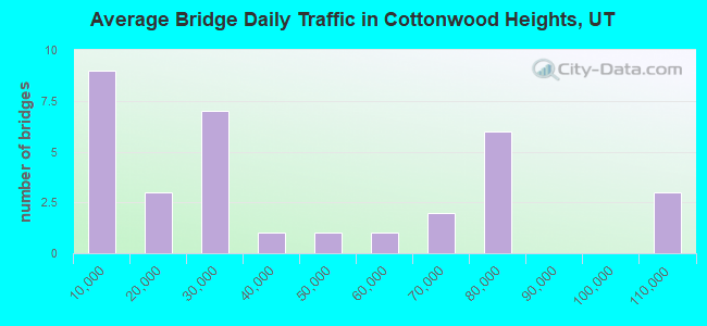
- 1,303,167Total average daily traffic
- 145,502Total average daily truck traffic
- National Bridge Inventory (NBI) Registered Bridges for Cottonwood Heights
- No street view available for this location
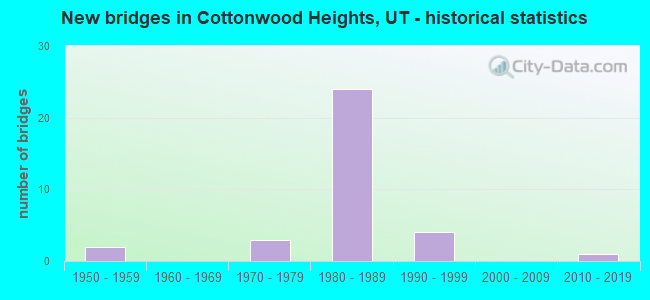
- New bridges - historical statistics
- 21950-1959
- 31970-1979
- 241980-1989
- 41990-1999
- 12010-2019
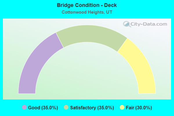
- Bridge Condition - Deck
- 35.0%Good
- 35.0%Satisfactory
- 30.0%Fair
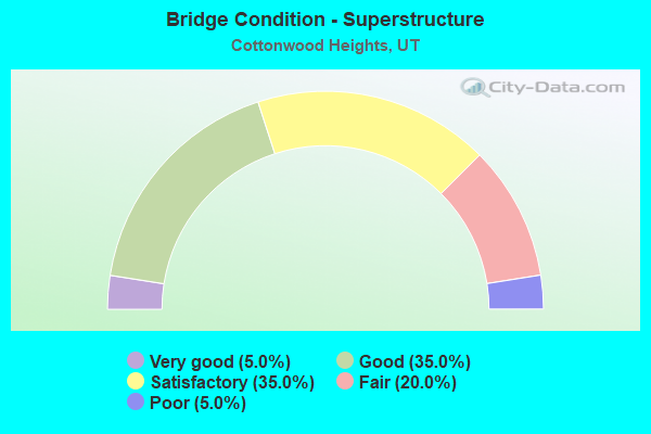
- Bridge Condition - Superstructure
- 5.0%Very good
- 35.0%Good
- 35.0%Satisfactory
- 20.0%Fair
- 5.0%Poor
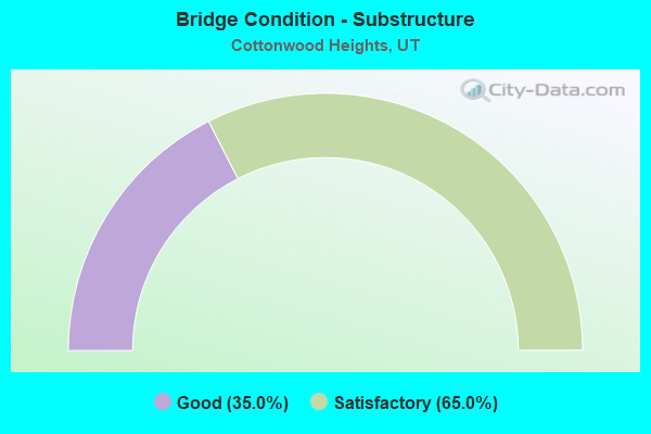
- Bridge Condition - Substructure
- 35.0%Good
- 65.0%Satisfactory
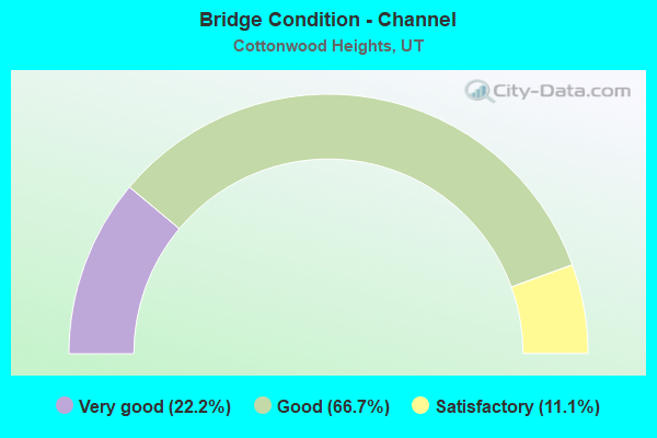
- Bridge Condition - Channel
- 22.2%Very good
- 66.7%Good
- 11.1%Satisfactory
Find on map >> Show street view
Structure Number: 35018D, Location: 1500 E 7000 S., SL.CO. (Lat: 40.625831, Lng: -111.851169), Route carried "on" structure: County highway 2116, Year Built: 1970, Year Reconstructed: 1986, Status: Open, Structure Length: 0.75m (2.46ft), Average Daily Traffic: 19,644 (year 2020), Average Future Daily Traffic: 24,555 (year 2040), Design Load: HS 20+Mod, Features Intersected: EAST JORDAN CANAL, Facility Carried by Structure: 7000 SOUTH STREET
Minimum Vertical Clearance: 30+ m (98+ ft), Kilometerpoint: 3.503, Lanes on structure: 5, Owner: City or Municipal Highway Agency, Approaching Roadway Width: 16.5m (54.1ft), Skew: 23 degrees, Material/Design: Concrete, Design/Construction: Slab, Number Of Spans In Main Unit: 1, Length of Maximum Span: 7.5m (24.6ft), Curb or Sidewalk Widths: Left: 2.9m (9.5ft), Right: 2.9m (9.5ft), Curb-To-Curb Width: 16.5m (54.1ft), Out-to-Out Width: 24.4m (80.1ft)
Condition: Deck: Fair, Superstructure: Fair, Substructure: Satisfactory, Channel: Good, Operating Rating: 32.4 metric tons, Method Used To Determine Operating Rating: Load and Resistance Factor Rating (LRFR) rating reported by rating factor(RF) method using HL-93 loadings, Inventory Rating: 19.4 metric tons, Method Used To Determine Inventory Rating: Load Factor (LF) rating reported by rating factor (RF) method using MS18 loading, Structural Evaluation: Meets minimum limits, Deck Geometry: High priority of replacement, Waterway Adequacy: Equal to present desirable criteria, Approach Roadway Alignment: Equal to present desirable criteria, Designated Inspection Frequency: Every 24 months, Inspection Date: December 2021, Deck Structure Type: Concrete Cast-file-Place, Wearing Surface/Protective System: Wearing Surface: Bituminous
Find on map >> Show street view
Structure Number: 35060D, Location: 6600 S. 3000 E., HOLLADAY (Lat: 40.631850, Lng: -111.806817), Route carried "on" structure: City street 2188, Year Built: 1996, Status: Open, Structure Length: 0.78m (2.56ft), Average Daily Traffic: 8,292 (year 2020), Average Future Daily Traffic: 10,365 (year 2040), Design Load: HS 20+Mod, Features Intersected: BIG COTTONWOOD CREEK, Facility Carried by Structure: 3000 EAST STREET
Minimum Vertical Clearance: 30+ m (98+ ft), Kilometerpoint: 0.885, Lanes on structure: 6, Owner: City or Municipal Highway Agency, Approaching Roadway Width: 23.6m (77.4ft), Skew: 2 degrees, Material/Design: Concrete, Design/Construction: Frame, Number Of Spans In Main Unit: 1, Length of Maximum Span: 7.4m (24.3ft), Curb or Sidewalk Widths: Left: 3.1m (10.2ft), Right: 2.1m (6.9ft), Curb-To-Curb Width: 23.6m (77.4ft), Out-to-Out Width: 39.7m (130.2ft)
Condition: Deck: Satisfactory, Superstructure: Satisfactory, Substructure: Satisfactory, Channel: Very good, Operating Rating: 32.4 metric tons, Method Used To Determine Operating Rating: Load and Resistance Factor Rating (LRFR) rating reported by rating factor(RF) method using HL-93 loadings, Inventory Rating: 19.8 metric tons, Method Used To Determine Inventory Rating: Load Factor (LF) rating reported by rating factor (RF) method using MS18 loading, Structural Evaluation: Somewhat better than minimum adequacy, Deck Geometry: Somewhat better than minimum adequacy, Waterway Adequacy: Better than present minimum criteria, Approach Roadway Alignment: Equal to present desirable criteria, Designated Inspection Frequency: Every 24 months, Inspection Date: December 2021, Deck Structure Type: Concrete Precast Panels, Wearing Surface/Protective System: Wearing Surface: Bituminous
Find on map >> Show street view
Structure Number: 35063D, Location: 0.5 MI.SE.KNUDSEN CORNER (Lat: 40.625750, Lng: -111.800603), Route carried "on" structure: County highway , Year Built: 1996, Status: Open, Structure Length: 0.86m (2.82ft), Average Daily Traffic: 1,260 (year 2020), Truck Traffic: 1%, Average Future Daily Traffic: 1,531 (year 2040), Design Load: HS 20+Mod, Features Intersected: BIG COTTONWOOD CREEK, Facility Carried by Structure: BIG CTTNWD.CYN.RD.
Minimum Vertical Clearance: 30+ m (98+ ft), Kilometerpoint: 0.037, Lanes on structure: 2, Owner: City or Municipal Highway Agency, Approaching Roadway Width: 13.6m (44.6ft), Skew: 3 degrees, Material/Design: Concrete, Design/Construction: Frame, Number Of Spans In Main Unit: 1, Length of Maximum Span: 8.0m (26.2ft), Curb or Sidewalk Widths: Left: 3.0m (9.8ft), Right: 3.0m (9.8ft), Curb-To-Curb Width: 13.6m (44.6ft), Out-to-Out Width: 20.1m (65.9ft)
Condition: Deck: Fair, Superstructure: Fair, Substructure: Satisfactory, Channel: Good, Operating Rating: 32.4 metric tons, Method Used To Determine Operating Rating: Load and Resistance Factor Rating (LRFR) rating reported by rating factor(RF) method using HL-93 loadings, Inventory Rating: 19.4 metric tons, Method Used To Determine Inventory Rating: Load Factor (LF) rating reported by rating factor (RF) method using MS18 loading, Structural Evaluation: Somewhat better than minimum adequacy, Deck Geometry: Superior to present desirable criteria, Waterway Adequacy: Equal to present desirable criteria, Approach Roadway Alignment: Equal to present desirable criteria, Designated Inspection Frequency: Every 24 months, Inspection Date: December 2021, Deck Structure Type: Concrete Precast Panels, Wearing Surface/Protective System: Wearing Surface: Bituminous
Find on map >> Show street view
Structure Number: 35071D, Location: 7900 S. 2000 E., SL.CO. (Lat: 40.607706, Lng: -111.832958), Route carried "on" structure: County highway 2082, Year Built: 1990, Status: Open, Structure Length: 0.79m (2.59ft), Average Daily Traffic: 29,731 (year 2020), Average Future Daily Traffic: 37,164 (year 2040), Design Load: HL 93, Features Intersected: LITTLE COTTONWOOD CREEK, Facility Carried by Structure: HIGHLAND DRIVE
Minimum Vertical Clearance: 30+ m (98+ ft), Kilometerpoint: 17.606, Lanes on structure: 5, Owner: City or Municipal Highway Agency, Approaching Roadway Width: 25.6m (84.0ft), Skew: 3 degrees, Material/Design: Concrete, Design/Construction: Frame, Number Of Spans In Main Unit: 1, Length of Maximum Span: 7.3m (24.0ft), Curb or Sidewalk Widths: Left: 1.2m (3.9ft), Right: 1.2m (3.9ft), Curb-To-Curb Width: 25.6m (84.0ft), Out-to-Out Width: 28.0m (91.9ft)
Condition: Deck: Satisfactory, Superstructure: Satisfactory, Substructure: Satisfactory, Channel: Good, Operating Rating: 32.4 metric tons, Method Used To Determine Operating Rating: Load and Resistance Factor Rating (LRFR) rating reported by rating factor(RF) method using HL-93 loadings, Inventory Rating: 19.8 metric tons, Method Used To Determine Inventory Rating: Load Factor (LF) rating reported by rating factor (RF) method using MS18 loading, Structural Evaluation: Somewhat better than minimum adequacy, Deck Geometry: Superior to present desirable criteria, Waterway Adequacy: Equal to present minimum criteria, Approach Roadway Alignment: Equal to present desirable criteria, Designated Inspection Frequency: Every 24 months, Inspection Date: December 2021, Deck Structure Type: Concrete Precast Panels, Wearing Surface/Protective System: Wearing Surface: Bituminous
Find on map >> Show street view
Structure Number: 35072D, Location: 8100 S. 2650 E., SL.CO. (Lat: 40.603881, Lng: -111.819264), Route carried "on" structure: County highway , Year Built: 1995, Status: Open, Structure Length: 0.78m (2.56ft), Average Daily Traffic: 1,260 (year 2020), Truck Traffic: 1%, Average Future Daily Traffic: 1,531 (year 2040), Design Load: HS 20+Mod, Features Intersected: LITTLE COTTONWOOD CREEK, Facility Carried by Structure: OAK CREEK DRIVE
Minimum Vertical Clearance: 30+ m (98+ ft), Kilometerpoint: 0.043, Lanes on structure: 2, Owner: City or Municipal Highway Agency, Approaching Roadway Width: 8.7m (28.5ft), Material/Design: Concrete, Design/Construction: Frame, Number Of Spans In Main Unit: 1, Length of Maximum Span: 7.3m (24.0ft), Curb or Sidewalk Widths: Left: 1.2m (3.9ft), Right: 1.2m (3.9ft), Curb-To-Curb Width: 8.7m (28.5ft), Out-to-Out Width: 15.2m (49.9ft)
Condition: Deck: Satisfactory, Superstructure: Satisfactory, Substructure: Good, Channel: Good, Operating Rating: 55.4 metric tons, Method Used To Determine Operating Rating: Load and Resistance Factor Rating (LRFR) rating reported by rating factor(RF) method using HL-93 loadings, Inventory Rating: 32.4 metric tons, Method Used To Determine Inventory Rating: Load Factor (LF) rating reported by rating factor (RF) method using MS18 loading, Structural Evaluation: Equal to present minimum criteria, Deck Geometry: Somewhat better than minimum adequacy, Waterway Adequacy: Better than present minimum criteria, Approach Roadway Alignment: Equal to present desirable criteria, Designated Inspection Frequency: Every 24 months, Inspection Date: December 2021, Deck Structure Type: Concrete Precast Panels, Wearing Surface/Protective System: Wearing Surface: Bituminous
Find on map >> Show street view
Structure Number: 35073D, Location: 2680 E. 8150 S., SL.CO. (Lat: 40.603078, Lng: -111.815997), Route carried "on" structure: County highway 2230, Year Built: 1970, Status: Posted for load, Structure Length: 1.01m (3.31ft), Average Daily Traffic: 11,805 (year 2020), Average Future Daily Traffic: 14,756 (year 2040), Design Load: HS 20+Mod, Features Intersected: LITTLE COTTONWOOD CREEK, Facility Carried by Structure: CREEK ROAD (8150S)
Minimum Vertical Clearance: 30.18m (99.02ft), Kilometerpoint: 5.079, Lanes on structure: 3, Owner: County Highway Agency, Approaching Roadway Width: 17.9m (58.7ft), Material/Design: Concrete, Design/Construction: Slab, Number Of Spans In Main Unit: 1, Length of Maximum Span: 9.1m (29.9ft), Curb or Sidewalk Widths: Left: 3.0m (9.8ft), Right: 1.5m (4.9ft), Curb-To-Curb Width: 17.9m (58.7ft), Out-to-Out Width: 24.4m (80.1ft)
Condition: Deck: Fair, Superstructure: Fair, Substructure: Satisfactory, Channel: Good, Operating Rating: 33.7 metric tons, Method Used To Determine Operating Rating: Load Factor (LF) rating reported by rating factor (RF) method using MS18 loading, Inventory Rating: 24.3 metric tons, Method Used To Determine Inventory Rating: Load Factor (LF) rating reported by rating factor (RF) method using MS18 loading, Structural Evaluation: Somewhat better than minimum adequacy, Deck Geometry: Superior to present desirable criteria, Waterway Adequacy: Better than present minimum criteria, Approach Roadway Alignment: Equal to present minimum criteria, Designated Inspection Frequency: Every 24 months, Inspection Date: December 2021, Deck Structure Type: Concrete Cast-file-Place, Wearing Surface/Protective System: Wearing Surface: Bituminous
Find on map >> Show street view
Structure Number: 35129F, Location: 7300 S.1300 E., SL.CO. (Lat: 40.619519, Lng: -111.856772), Route carried "on" structure: County highway 2068, Year Built: 1988, Status: Open, Structure Length: 1.19m (3.90ft), Average Daily Traffic: 40,018 (year 2020), Average Future Daily Traffic: 50,023 (year 2040), Design Load: HS 20+Mod, Features Intersected: LITTLE COTTONWOOD CREEK, Facility Carried by Structure: 1300 EAST STREET
Minimum Vertical Clearance: 30+ m (98+ ft), Kilometerpoint: 13.304, Lanes on structure: 6, Owner: City or Municipal Highway Agency, Approaching Roadway Width: 28.0m (91.9ft), Skew: 21 degrees, Material/Design: Prestressed concrete, Design/Construction: Tee Beam, Number Of Spans In Main Unit: 1, Length of Maximum Span: 10.5m (34.4ft), Curb or Sidewalk Widths: Left: 1.2m (3.9ft), Right: 1.2m (3.9ft), Curb-To-Curb Width: 28.0m (91.9ft), Out-to-Out Width: 31.7m (104.0ft)
Condition: Deck: Satisfactory, Superstructure: Satisfactory, Substructure: Good, Channel: Good, Operating Rating: 32.4 metric tons, Method Used To Determine Operating Rating: Load and Resistance Factor Rating (LRFR) rating reported by rating factor(RF) method using HL-93 loadings, Inventory Rating: 22.4 metric tons, Method Used To Determine Inventory Rating: Load Factor (LF) rating reported by rating factor (RF) method using MS18 loading, Structural Evaluation: Somewhat better than minimum adequacy, Deck Geometry: Superior to present desirable criteria, Waterway Adequacy: Better than present minimum criteria, Approach Roadway Alignment: Equal to present desirable criteria, Designated Inspection Frequency: Every 24 months, Inspection Date: December 2021, Deck Structure Type: Concrete Precast Panels, Wearing Surface/Protective System: Wearing Surface: Bituminous
Find on map >> Show street view
Structure Number: 35130F, Location: 7900 S.1745 E., SL.CO. (Lat: 40.615000, Lng: -111.843100), Route carried "on" structure: County highway , Year Built: 1987, Status: Open, Structure Length: 1.53m (5.02ft), Average Daily Traffic: 13 (year 2020), Average Future Daily Traffic: 15 (year 2040), Design Load: HS 20+Mod, Features Intersected: LITTLE COTTONWOOD CREEK, Facility Carried by Structure: COUNTY PARK ROAD
Minimum Vertical Clearance: 30+ m (98+ ft), Kilometerpoint: 0.000, Lanes on structure: 2, Owner: City or Municipal Highway Agency, Approaching Roadway Width: 8.2m (26.9ft), Material/Design: Prestressed concrete, Design/Construction: Tee Beam, Number Of Spans In Main Unit: 1, Length of Maximum Span: 14.8m (48.6ft), Curb or Sidewalk Widths: Left: 1.8m (5.9ft), Right: 1.8m (5.9ft), Curb-To-Curb Width: 8.2m (26.9ft), Out-to-Out Width: 12.5m (41.0ft)
Condition: Deck: Good, Superstructure: Good, Substructure: Good, Channel: Good, Operating Rating: 32.4 metric tons, Method Used To Determine Operating Rating: Load and Resistance Factor Rating (LRFR) rating reported by rating factor(RF) method using HL-93 loadings, Inventory Rating: 22.7 metric tons, Method Used To Determine Inventory Rating: Load Factor (LF) rating reported by rating factor (RF) method using MS18 loading, Structural Evaluation: Equal to present minimum criteria, Deck Geometry: Equal to present minimum criteria, Waterway Adequacy: Equal to present desirable criteria, Approach Roadway Alignment: Equal to present desirable criteria, Designated Inspection Frequency: Every 24 months, Inspection Date: December 2021, Deck Structure Type: Concrete Precast Panels, Wearing Surface/Protective System: Wearing Surface: Bituminous
Find on map >> Show street view
Structure Number: 35134D, Location: 1200 E. 6870 S., SL.CO. (Lat: 40.625778, Lng: -111.857992), Route carried "on" structure: County highway 2116, Year Built: 1972, Status: Open, Structure Length: 0.73m (2.40ft), Average Daily Traffic: 28,368 (year 2020), Average Future Daily Traffic: 35,460 (year 2040), Design Load: HL 93, Features Intersected: LITTLE COTTONWOOD CREEK, Facility Carried by Structure: FORT UNION BLVD.
Minimum Vertical Clearance: 30+ m (98+ ft), Kilometerpoint: 2.919, Lanes on structure: 7, Owner: City or Municipal Highway Agency, Approaching Roadway Width: 31.1m (102.0ft), Skew: 20 degrees, Material/Design: Concrete, Design/Construction: Frame, Number Of Spans In Main Unit: 1, Length of Maximum Span: 6.7m (22.0ft), Curb or Sidewalk Widths: Left: 2.8m (9.2ft), Right: 2.1m (6.9ft), Curb-To-Curb Width: 31.1m (102.0ft), Out-to-Out Width: 37.6m (123.4ft)
Condition: Deck: Satisfactory, Superstructure: Satisfactory, Substructure: Satisfactory, Channel: Good, Operating Rating: 34.0 metric tons, Method Used To Determine Operating Rating: Load and Resistance Factor Rating (LRFR) rating reported by rating factor(RF) method using HL-93 loadings, Inventory Rating: 23.7 metric tons, Method Used To Determine Inventory Rating: Load and Resistance Factor Rating (LRFR) rating reported by rating factor(RF) method using HL-93 loadings, Structural Evaluation: Somewhat better than minimum adequacy, Deck Geometry: Better than present minimum criteria, Waterway Adequacy: Equal to present desirable criteria, Approach Roadway Alignment: Equal to present desirable criteria, Designated Inspection Frequency: Every 24 months, Inspection Date: December 2021, Deck Structure Type: Concrete Cast-file-Place, Wearing Surface/Protective System: Wearing Surface: Bituminous
Find on map >> Show street view
Structure Number: 35151E, Location: 7075 S. 1250 E., MIDVALE (Lat: 40.623008, Lng: -111.857703), Route carried "on" structure: City street 2084, Year Built: 1988, Status: Open, Structure Length: 1.81m (5.94ft), Average Daily Traffic: 31,391 (year 2020), Average Future Daily Traffic: 39,239 (year 2040), Design Load: HS 20, Features Intersected: LITTLE COTTONWOOD CREEK, Facility Carried by Structure: UNION PARK AVE.
Minimum Vertical Clearance: 30+ m (98+ ft), Kilometerpoint: 0.171, Lanes on structure: 6, Owner: City or Municipal Highway Agency, Approaching Roadway Width: 23.5m (77.1ft), Skew: 25 degrees, Material/Design: Concrete continuous, Design/Construction: Culvert, Number Of Spans In Main Unit: 2, Length of Maximum Span: 8.5m (27.9ft), Curb or Sidewalk Widths: Left: 1.5m (4.9ft), Right: 1.5m (4.9ft)
Condition: Channel: Good, Culverts: Fair, Operating Rating: 63.2 metric tons, Method Used To Determine Operating Rating: Load and Resistance Factor Rating (LRFR) rating reported by rating factor(RF) method using HL-93 loadings, Inventory Rating: 48.3 metric tons, Method Used To Determine Inventory Rating: Load and Resistance Factor Rating (LRFR) rating reported by rating factor(RF) method using HL-93 loadings, Structural Evaluation: Somewhat better than minimum adequacy, Waterway Adequacy: Better than present minimum criteria, Approach Roadway Alignment: Equal to present desirable criteria, Designated Inspection Frequency: Every 24 months, Inspection Date: December 2019
Find on map >> Show street view
Structure Number: C 759, Location: .2 MI SW KNUDSON CNR INT (Lat: 40.635425, Lng: -111.810861), Route carried "on" structure: Interstate 215, Year Built: 1989, Status: Open, Structure Length: 5.76m (18.90ft), Average Daily Traffic: 62,062 (year 2020), Truck Traffic: 12%, Average Future Daily Traffic: 77,578 (year 2040), Design Load: HS 20+Mod, Features Intersected: HLDY.BLVD.& BIG CTNW
Minimum Vertical Clearance: 30+ m (98+ ft), Kilometerpoint: 10.388, Lanes on structure: 6, Lanes under structure: 2, Base Highway Network: Yes, Owner: State Highway Agency, Approaching Roadway Width: 34.1m (111.9ft), Skew: 1 degrees, Material/Design: Steel, Design/Construction: Stringer/Multi-beam, Number Of Spans In Main Unit: 1, Length of Maximum Span: 56.7m (186.0ft), Curb-To-Curb Width: 35.9m (117.8ft), Out-to-Out Width: 37.9m (124.3ft)
Condition: Deck: Good, Superstructure: Good, Substructure: Satisfactory, Channel: Very good, Operating Rating: 70.6 metric tons, Method Used To Determine Operating Rating: Load and Resistance Factor Rating (LRFR) rating reported by rating factor(RF) method using HL-93 loadings, Inventory Rating: 66.7 metric tons, Method Used To Determine Inventory Rating: Load Factor (LF) rating reported by rating factor (RF) method using MS18 loading, Structural Evaluation: Equal to present minimum criteria, Deck Geometry: Superior to present desirable criteria, Underclear: Meets minimum limits, Waterway Adequacy: Equal to present desirable criteria, Approach Roadway Alignment: Equal to present desirable criteria, Designated Inspection Frequency: Every 24 months, Inspection Date: September 2020, Deck Structure Type: Concrete Cast-file-Place, Wearing Surface/Protective System: Wearing Surface: Epoxy Overlay, Deck Protection: Epoxy Coated Reinforcing
Find on map >> Show street view
Structure Number: E 907, Location: AT WATER TREATMENT PLANT (Lat: 40.618542, Lng: -111.781456), Route carried "on" structure: State highway 190, Year Built: 1954, Status: Open, Structure Length: 0.93m (3.05ft), Average Daily Traffic: 7,883 (year 2020), Truck Traffic: 13%, Average Future Daily Traffic: 9,854 (year 2040), Design Load: HS 20+Mod, Features Intersected: BIG COTTONWOOD CREEK
Minimum Vertical Clearance: 30.18m (99.02ft), Kilometerpoint: 3.649, Lanes on structure: 2, Owner: State Highway Agency, Approaching Roadway Width: 9.1m (29.9ft), Skew: 4 degrees, Material/Design: Concrete, Design/Construction: Culvert, Number Of Spans In Main Unit: 1, Length of Maximum Span: 8.6m (28.2ft)
Condition: Channel: Good, Culverts: Fair, Operating Rating: 47.3 metric tons, Method Used To Determine Operating Rating: Load Factor (LF) rating reported by rating factor (RF) method using MS18 loading, Inventory Rating: 28.8 metric tons, Method Used To Determine Inventory Rating: Load Factor (LF) rating reported by rating factor (RF) method using MS18 loading, Structural Evaluation: Somewhat better than minimum adequacy, Waterway Adequacy: Better than present minimum criteria, Approach Roadway Alignment: Equal to present desirable criteria, Designated Inspection Frequency: Every 24 months, Inspection Date: September 2020
Find on map >> Show street view
Structure Number: F 475, Location: 6600 SO 1000 EAST,SL.CO. (Lat: 40.629775, Lng: -111.862450), Route carried "on" structure: County highway 2084, Year Built: 1984, Status: Open, Structure Length: 6.86m (22.51ft), Average Daily Traffic: 20,678 (year 2020), Average Future Daily Traffic: 25,848 (year 2040), Design Load: HS 20+Mod, Features Intersected: I-215 (SR-215) EBL & WB, Facility Carried by Structure: 1000 EAST STREET
Minimum Vertical Clearance: 5.97m (19.59ft), Kilometerpoint: 1.062, Lanes on structure: 3, Lanes under structure: 6, Owner: State Highway Agency, Approaching Roadway Width: 20.1m (65.9ft), Skew: 20 degrees, Material/Design: Prestressed concrete continuous, Design/Construction: Stringer/Multi-beam, Number Of Spans In Main Unit: 2, Length of Maximum Span: 35.4m (116.1ft), Curb-To-Curb Width: 21.0m (68.9ft), Out-to-Out Width: 22.0m (72.2ft)
Condition: Deck: Good, Superstructure: Good, Substructure: Satisfactory, Operating Rating: 39.9 metric tons, Method Used To Determine Operating Rating: Load and Resistance Factor Rating (LRFR) rating reported by rating factor(RF) method using HL-93 loadings, Inventory Rating: 29.8 metric tons, Method Used To Determine Inventory Rating: Load and Resistance Factor Rating (LRFR) rating reported by rating factor(RF) method using HL-93 loadings, Structural Evaluation: Equal to present minimum criteria, Deck Geometry: Better than present minimum criteria, Underclear: Equal to present minimum criteria, Approach Roadway Alignment: Equal to present desirable criteria, Designated Inspection Frequency: Every 24 months, Inspection Date: October 2020, Deck Structure Type: Concrete Cast-file-Place, Wearing Surface/Protective System: Wearing Surface: Monolithic Concrete, Deck Protection: Epoxy Coated Reinforcing
Find on map >> Show street view
Structure Number: F 476, Location: NEAR STORM MOUNTAIN (Lat: 40.623106, Lng: -111.750586), Route carried "on" structure: State highway 190, Year Built: 1983, Status: Open, Structure Length: 3.89m (12.76ft), Average Daily Traffic: 7,883 (year 2020), Truck Traffic: 13%, Average Future Daily Traffic: 9,854 (year 2040), Design Load: HS 20+Mod, Features Intersected: BIG COTTONWOOD CREEK
Minimum Vertical Clearance: 30.18m (99.02ft), Kilometerpoint: 6.709, Lanes on structure: 2, Owner: State Highway Agency, Approaching Roadway Width: 16.5m (54.1ft), Material/Design: Prestressed concrete, Design/Construction: Stringer/Multi-beam, Number Of Spans In Main Unit: 1, Length of Maximum Span: 38.1m (125.0ft), Curb-To-Curb Width: 15.7m (51.5ft), Out-to-Out Width: 16.5m (54.1ft)
Condition: Deck: Satisfactory, Superstructure: Satisfactory, Substructure: Satisfactory, Channel: Good, Operating Rating: 48.6 metric tons, Method Used To Determine Operating Rating: Load and Resistance Factor Rating (LRFR) rating reported by rating factor(RF) method using HL-93 loadings, Inventory Rating: 15.6 metric tons, Method Used To Determine Inventory Rating: Load Factor (LF) rating reported by rating factor (RF) method using MS18 loading, Structural Evaluation: High priority of corrective action, Deck Geometry: Superior to present desirable criteria, Waterway Adequacy: Equal to present desirable criteria, Approach Roadway Alignment: Equal to present desirable criteria, Designated Inspection Frequency: Every 24 months, Inspection Date: September 2020, Deck Structure Type: Concrete Cast-file-Place, Wearing Surface/Protective System: Wearing Surface: Bituminous, Membrane: Preformed Fabric, Deck Protection: Epoxy Coated Reinforcing
Find on map >> Show street view
Structure Number: F 504, Location: 6650 SO.1300 EAST SL.CTY. (Lat: 40.630125, Lng: -111.854722), Route carried "on" structure: County highway 2068, Year Built: 1984, Status: Open, Structure Length: 7.22m (23.69ft), Average Daily Traffic: 17,157 (year 2020), Average Future Daily Traffic: 21,446 (year 2040), Design Load: HS 20+Mod, Features Intersected: I-215 (SR-215) EBL &, Facility Carried by Structure: 1300 EAST STREET
Minimum Vertical Clearance: 30+ m (98+ ft), Kilometerpoint: 14.535, Lanes on structure: 4, Lanes under structure: 6, Owner: State Highway Agency, Approaching Roadway Width: 19.2m (63.0ft), Material/Design: Prestressed concrete continuous, Design/Construction: Stringer/Multi-beam, Number Of Spans In Main Unit: 2, Length of Maximum Span: 38.1m (125.0ft), Curb or Sidewalk Widths: Left: 1.2m (3.9ft), Right: 1.2m (3.9ft), Curb-To-Curb Width: 20.4m (66.9ft), Out-to-Out Width: 24.3m (79.7ft)
Condition: Deck: Satisfactory, Superstructure: Good, Substructure: Satisfactory, Operating Rating: 45.4 metric tons, Method Used To Determine Operating Rating: Load and Resistance Factor Rating (LRFR) rating reported by rating factor(RF) method using HL-93 loadings, Inventory Rating: 40.8 metric tons, Method Used To Determine Inventory Rating: Load and Resistance Factor Rating (LRFR) rating reported by rating factor(RF) method using HL-93 loadings, Structural Evaluation: Equal to present minimum criteria, Deck Geometry: Superior to present desirable criteria, Underclear: Equal to present minimum criteria, Approach Roadway Alignment: Equal to present desirable criteria, Designated Inspection Frequency: Every 24 months, Inspection Date: September 2020, Deck Structure Type: Concrete Cast-file-Place, Wearing Surface/Protective System: Wearing Surface: Monolithic Concrete, Deck Protection: Epoxy Coated Reinforcing
Find on map >> Show street view
Structure Number: F 562, Location: MOUTH OF BIG CTW. CANYON (Lat: 40.620064, Lng: -111.789553), Route carried "on" structure: State highway 190, Year Built: 1989, Status: Open, Structure Length: 4.06m (13.32ft), Average Daily Traffic: 20,126 (year 2020), Truck Traffic: 13%, Average Future Daily Traffic: 25,158 (year 2040), Design Load: HS 20+Mod, Features Intersected: BIG COTTONWOOD CREEK
Minimum Vertical Clearance: 30.18m (99.02ft), Kilometerpoint: 2.876, Lanes on structure: 7, Base Highway Network: Yes, Owner: State Highway Agency, Approaching Roadway Width: 28.0m (91.9ft), Skew: 2 degrees, Material/Design: Prestressed concrete, Design/Construction: Stringer/Multi-beam, Number Of Spans In Main Unit: 1, Length of Maximum Span: 39.7m (130.2ft), Curb-To-Curb Width: 28.7m (94.2ft), Out-to-Out Width: 32.6m (107.0ft)
Condition: Deck: Good, Superstructure: Good, Substructure: Satisfactory, Channel: Satisfactory, Operating Rating: 58.0 metric tons, Method Used To Determine Operating Rating: Load and Resistance Factor Rating (LRFR) rating reported by rating factor(RF) method using HL-93 loadings, Inventory Rating: 36.6 metric tons, Method Used To Determine Inventory Rating: Load Factor (LF) rating reported by rating factor (RF) method using MS18 loading, Structural Evaluation: Equal to present minimum criteria, Deck Geometry: Somewhat better than minimum adequacy, Waterway Adequacy: Equal to present desirable criteria, Approach Roadway Alignment: Equal to present desirable criteria, Designated Inspection Frequency: Every 24 months, Inspection Date: September 2020, Deck Structure Type: Concrete Cast-file-Place, Wearing Surface/Protective System: Wearing Surface: Latex Concrete, Deck Protection: Epoxy Coated Reinforcing
Find on map >> Show street view
Structure Number: F 798, Location: Big Cottonwood Canyon (Lat: 40.625833, Lng: -111.742067), Route carried "on" structure: State highway , Year Built: 2012, Status: Open, Structure Length: 2.55m (8.37ft), Average Daily Traffic: 2,633 (year 2020), Truck Traffic: 9%, Average Future Daily Traffic: 3,291 (year 2040), Design Load: HL 93, Features Intersected: BIG COTTONWOOD CREEK, Facility Carried by Structure: SR-190
Minimum Vertical Clearance: 30+ m (98+ ft), Kilometerpoint: 0.049, Lanes on structure: 2, Owner: State Highway Agency, Approaching Roadway Width: 12.2m (40.0ft), Skew: 9 degrees, Material/Design: Prestressed concrete, Design/Construction: Stringer/Multi-beam, Number Of Spans In Main Unit: 1, Length of Maximum Span: 23.9m (78.4ft), Curb-To-Curb Width: 12.2m (40.0ft), Out-to-Out Width: 13.1m (43.0ft)
Condition: Deck: Good, Superstructure: Very good, Substructure: Good, Channel: Very good, Operating Rating: 62.5 metric tons, Method Used To Determine Operating Rating: Load and Resistance Factor Rating (LRFR) rating reported by rating factor(RF) method using HL-93 loadings, Inventory Rating: 38.9 metric tons, Method Used To Determine Inventory Rating: Load and Resistance Factor Rating (LRFR) rating reported by rating factor(RF) method using HL-93 loadings, Structural Evaluation: Better than present minimum criteria, Deck Geometry: Equal to present minimum criteria, Waterway Adequacy: Equal to present desirable criteria, Approach Roadway Alignment: Equal to present minimum criteria, Designated Inspection Frequency: Every 24 months, Inspection Date: September 2020, Deck Structure Type: Concrete Cast-file-Place, Wearing Surface/Protective System: Wearing Surface: Epoxy Overlay, Deck Protection: Epoxy Coated Reinforcing
Find on map >> Show street view
Structure Number: 2C 761, Location: .2 MI.SW. KNUDSON CNR INT (Lat: 40.634781, Lng: -111.811261), Route carried "on" structure: Ramp Interstate 215, Year Built: 1989, Status: Open, Structure Length: 5.88m (19.29ft), Average Daily Traffic: 25,500 (year 2020), Truck Traffic: 15%, Average Future Daily Traffic: 31,875 (year 2040), Design Load: HS 20+Mod, Features Intersected: HLDY.BLVD.& BIG CTNW
Minimum Vertical Clearance: 30+ m (98+ ft), Kilometerpoint: 0.323, Lanes on structure: 2, Lanes under structure: 2, Owner: State Highway Agency, Approaching Roadway Width: 11.0m (36.1ft), Skew: 2 degrees, Material/Design: Steel, Design/Construction: Stringer/Multi-beam, Number Of Spans In Main Unit: 1, Length of Maximum Span: 57.8m (189.6ft), Curb-To-Curb Width: 11.8m (38.7ft), Out-to-Out Width: 13.9m (45.6ft)
Condition: Deck: Good, Superstructure: Good, Substructure: Good, Channel: Good, Operating Rating: 77.8 metric tons, Method Used To Determine Operating Rating: Load and Resistance Factor Rating (LRFR) rating reported by rating factor(RF) method using HL-93 loadings, Inventory Rating: 71.3 metric tons, Method Used To Determine Inventory Rating: Load Factor (LF) rating reported by rating factor (RF) method using MS18 loading, Structural Evaluation: Better than present minimum criteria, Deck Geometry: Superior to present desirable criteria, Underclear: Meets minimum limits, Waterway Adequacy: Equal to present desirable criteria, Approach Roadway Alignment: Equal to present desirable criteria, Designated Inspection Frequency: Every 24 months, Inspection Date: September 2020, Deck Structure Type: Concrete Cast-file-Place, Wearing Surface/Protective System: Wearing Surface: Monolithic Concrete, Deck Protection: Epoxy Coated Reinforcing
Find on map >> Show street view
Structure Number: 4C 727, Location: 6600 So. 1000 EAST (Lat: 40.629458, Lng: -111.861253), Route carried "on" structure: Ramp Interstate 215, Year Built: 1984, Status: Open, Structure Length: 22.95m (75.30ft), Average Daily Traffic: 25,500 (year 2020), Truck Traffic: 15%, Average Future Daily Traffic: 31,875 (year 2040), Design Load: HS 20+Mod, Features Intersected: 1000 E.St.& I-215(SR-80)
Minimum Vertical Clearance: 30.18m (99.02ft), Kilometerpoint: 0.438, Lanes on structure: 2, Lanes under structure: 13, Owner: State Highway Agency, Approaching Roadway Width: 11.0m (36.1ft), Skew: 9 degrees, Material/Design: Steel continuous, Design/Construction: Stringer/Multi-beam, Number Of Spans In Main Unit: 5, Length of Maximum Span: 50.6m (166.0ft), Curb-To-Curb Width: 11.6m (38.1ft), Out-to-Out Width: 12.9m (42.3ft)
Condition: Deck: Fair, Superstructure: Fair, Substructure: Satisfactory, Operating Rating: 46.0 metric tons, Method Used To Determine Operating Rating: Load and Resistance Factor Rating (LRFR) rating reported by rating factor(RF) method using HL-93 loadings, Inventory Rating: 29.2 metric tons, Method Used To Determine Inventory Rating: Load and Resistance Factor Rating (LRFR) rating reported by rating factor(RF) method using HL-93 loadings, Structural Evaluation: Somewhat better than minimum adequacy, Deck Geometry: Superior to present desirable criteria, Underclear: Equal to present minimum criteria, Approach Roadway Alignment: Equal to present minimum criteria, Designated Inspection Frequency: Every 24 months, Critical Feature Inspection Frequency: Every 24 months, Inspection Date: September 2020, Critical Feature Inspection Date: September 2020, Deck Structure Type: Concrete Cast-file-Place, Wearing Surface/Protective System: Wearing Surface: Epoxy Overlay, Deck Protection: Epoxy Coated Reinforcing
Find on map >> Show street view
Structure Number: 4C 736, Location: 6600 SO.2000 EAST,S.L.CO. (Lat: 40.631858, Lng: -111.833139), Route carried "on" structure: Ramp Interstate 215, Year Built: 1987, Status: Open, Structure Length: 26.14m (85.76ft), Average Daily Traffic: 25,500 (year 2020), Truck Traffic: 15%, Average Future Daily Traffic: 31,875 (year 2040), Design Load: HS 20, Features Intersected: SR-152 & I-215 (SR-215)
Minimum Vertical Clearance: 5.03m (16.50ft), Kilometerpoint: 0.292, Lanes on structure: 1, Lanes under structure: 12, Owner: State Highway Agency, Approaching Roadway Width: 8.5m (27.9ft), Skew: 9 degrees, Material/Design: Steel continuous, Design/Construction: Stringer/Multi-beam, Number Of Spans In Main Unit: 5, Length of Maximum Span: 53.3m (174.9ft), Curb-To-Curb Width: 8.2m (26.9ft), Out-to-Out Width: 9.1m (29.9ft)
Condition: Deck: Fair, Superstructure: Satisfactory, Substructure: Satisfactory, Operating Rating: 32.7 metric tons, Method Used To Determine Operating Rating: Load and Resistance Factor Rating (LRFR) rating reported by rating factor(RF) method using HL-93 loadings, Inventory Rating: 15.6 metric tons, Method Used To Determine Inventory Rating: Load and Resistance Factor Rating (LRFR) rating reported by rating factor(RF) method using HL-93 loadings, Structural Evaluation: High priority of corrective action, Deck Geometry: Superior to present desirable criteria, Underclear: High priority of corrective action, Approach Roadway Alignment: Equal to present minimum criteria, Designated Inspection Frequency: Every 24 months, Critical Feature Inspection Frequency: Every 24 months, Inspection Date: September 2020, Critical Feature Inspection Date: September 2020, Deck Structure Type: Concrete Cast-file-Place, Wearing Surface/Protective System: Wearing Surface: Epoxy Overlay, Deck Protection: Epoxy Coated Reinforcing
Find on map >> Show street view
Structure Number: 41901000001031, Location: EAST OF SLC (Lat: 40.622117, Lng: -111.769675), Route carried "on" structure: Federal lands road 80014, Year Built: 1984, Status: Open, Structure Length: 1.22m (4.00ft), Average Daily Traffic: 25 (year 0000), Average Future Daily Traffic: 37 (year 2042), Design Load: HS 20, Features Intersected: BIG COTTON WOOD CREEK
Minimum Vertical Clearance: 30+ m (98+ ft), Kilometerpoint: 0.160, Lanes on structure: 1, Owner: U.S. Forest Service, Approaching Roadway Width: 4.3m (14.1ft), Skew: 2 degrees, Material/Design: Prestressed concrete, Design/Construction: Slab, Number Of Spans In Main Unit: 1, Length of Maximum Span: 11.6m (38.1ft), Curb or Sidewalk Widths: Left: 0.3m (1.0ft), Right: 0.3m (1.0ft), Curb-To-Curb Width: 4.3m (14.1ft), Out-to-Out Width: 4.9m (16.1ft)
Condition: Deck: Good, Superstructure: Good, Substructure: Good, Channel: Very good, Operating Rating: 55.4 metric tons, Method Used To Determine Operating Rating: Allowable Stress (AS), Inventory Rating: 48.1 metric tons, Method Used To Determine Inventory Rating: Allowable Stress (AS), Structural Evaluation: Better than present minimum criteria, Deck Geometry: Equal to present minimum criteria, Waterway Adequacy: Superior to present desirable criteria, Approach Roadway Alignment: Equal to present minimum criteria, Designated Inspection Frequency: Every 24 months, Inspection Date: November 2021, Deck Structure Type: Other, Wearing Surface/Protective System: Wearing Surface: Bituminous
Find on map >> Show street view
Structure Number: 41901000001075, Location: MOUTH OF BIG COTTONWOOD N (Lat: 40.621117, Lng: -111.771683), Route carried "on" structure: Federal lands road 80633, Year Built: 1952, Status: Open, Structure Length: 0.79m (2.59ft), Average Daily Traffic: 50 (year 0000), Average Future Daily Traffic: 75 (year 2042), Design Load: H 20, Features Intersected: BIG COTTONWOOD CK
Minimum Vertical Clearance: 30+ m (98+ ft), Kilometerpoint: 0.160, Lanes on structure: 1, Owner: U.S. Forest Service, Approaching Roadway Width: 3.8m (12.5ft), Material/Design: Wood or Timber, Design/Construction: Girder and Floorbeam System, Number Of Spans In Main Unit: 1, Length of Maximum Span: 7.5m (24.6ft), Curb-To-Curb Width: 3.8m (12.5ft), Out-to-Out Width: 4.3m (14.1ft)
Condition: Deck: Fair, Superstructure: Poor, Substructure: Good, Channel: Satisfactory, Operating Rating: 21.7 metric tons, Method Used To Determine Operating Rating: Load and Resistance Factor Rating (LRFR) rating reported by rating factor(RF) method using HL-93 loadings, Inventory Rating: 16.8 metric tons, Method Used To Determine Inventory Rating: Load and Resistance Factor Rating (LRFR) rating reported by rating factor(RF) method using HL-93 loadings, Structural Evaluation: Meets minimum limits, Deck Geometry: Meets minimum limits, Waterway Adequacy: Equal to present desirable criteria, Approach Roadway Alignment: Equal to present minimum criteria, Designated Inspection Frequency: Every 24 months, Inspection Date: October 2020, Deck Structure Type: Wood or Timber, Wearing Surface/Protective System: Wearing Surface: Bituminous
Find on map >> Show street view
Structure Number: C 759, Location: .2 MI SW KNUDSON CNR INT (Lat: 40.635425, Lng: -111.810861), Route carried "under" structure: County highway , Year Built: 1989, Structure Length: 0. m, Average Daily Traffic: 69,000 (year 2020), Truck Traffic: 9%, Features Intersected: HLDY.BLVD.& BIG CTNW, Facility Carried by Structure: I-215 (SR-215)
Minimum Vertical Clearance: 5.31m (17.42ft), Kilometerpoint: 0.000, Lanes on structure: 6, Lanes under structure: 2, Material/Design: Steel, Design/Construction: Stringer/Multi-beam, Length of Maximum Span: 56.7m (186.0ft)
Find on map >> Show street view
Structure Number: F 475, Location: 6600 SO 1000 EAST,SL.CO. (Lat: 40.629775, Lng: -111.862450), Route carried "under" structure: Interstate 215, Year Built: 1984, Structure Length: 0. m, Average Daily Traffic: 105,506 (year 2020), Truck Traffic: 15%, Features Intersected: I-215 (SR-215) EBL & WB, Facility Carried by Structure: 1000 EAST STREET
Minimum Vertical Clearance: 5.05m (16.57ft), Kilometerpoint: 14.948, Lanes on structure: 3, Lanes under structure: 6, Material/Design: Prestressed concrete continuous, Design/Construction: Stringer/Multi-beam, Length of Maximum Span: 35.4m (116.1ft)
Find on map >> Show street view
Structure Number: F 504, Location: 6650 SO.1300 EAST SL.CTY. (Lat: 40.630125, Lng: -111.854722), Route carried "under" structure: Interstate 215, Year Built: 1984, Structure Length: 0. m, Average Daily Traffic: 79,810 (year 2020), Truck Traffic: 13%, Features Intersected: I-215 (SR-215) EBL &, Facility Carried by Structure: 1300 EAST STREET
Minimum Vertical Clearance: 5.64m (18.50ft), Kilometerpoint: 14.169, Lanes on structure: 4, Lanes under structure: 6, Material/Design: Prestressed concrete continuous, Design/Construction: Stringer/Multi-beam, Length of Maximum Span: 38.1m (125.0ft)
Find on map >> Show street view
Structure Number: R 36, Location: EAST OF 9TH EAST STRUCT. (Lat: 40.630217, Lng: -111.864761), Route carried "under" structure: Interstate 215, Year Built: 1984, Structure Length: 0. m, Average Daily Traffic: 105,506 (year 2020), Truck Traffic: 15%, Features Intersected: I-215 (SR-215) EBL & WBL, Facility Carried by Structure: PIPE FLUME-IRRIG.
Minimum Vertical Clearance: 5.61m (18.41ft), Kilometerpoint: 15.041, Lanes under structure: 12, Material/Design: Steel continuous, Design/Construction: Stringer/Multi-beam, Length of Maximum Span: 59.1m (193.9ft)
Find on map >> Show street view
Structure Number: R 54, Location: EAST OF 1300 EAST STRUCT. (Lat: 40.630569, Lng: -111.854558), Route carried "under" structure: Interstate 215, Year Built: 1984, Structure Length: 0. m, Average Daily Traffic: 79,810 (year 2020), Truck Traffic: 13%, Features Intersected: I-215 (SR-215) EBL &, Facility Carried by Structure: PIPE FLUMES-UTIY.
Minimum Vertical Clearance: 5.82m (19.09ft), Kilometerpoint: 14.176, Lanes under structure: 6, Material/Design: Steel continuous, Design/Construction: Stringer/Multi-beam, Length of Maximum Span: 37.8m (124.0ft)
Find on map >> Show street view
Structure Number: R 55, Location: EAST OF 1100 EAST STRUCT. (Lat: 40.630286, Lng: -111.858544), Route carried "under" structure: Interstate 215, Year Built: 1984, Structure Length: 0. m, Average Daily Traffic: 79,810 (year 2020), Truck Traffic: 13%, Features Intersected: I-215 (SR-215) EBL &, Facility Carried by Structure: IRRIG. PIPE FLUME
Minimum Vertical Clearance: 5.18m (16.99ft), Kilometerpoint: 14.515, Lanes under structure: 8, Material/Design: Steel continuous, Design/Construction: Stringer/Multi-beam, Length of Maximum Span: 42.7m (140.1ft)
Find on map >> Show street view
Structure Number: R 56, Location: EAST OF 1100 EAST STRUCT. (Lat: 40.630239, Lng: -111.859586), Route carried "under" structure: Interstate 215, Year Built: 1984, Structure Length: 0. m, Average Daily Traffic: 79,810 (year 2020), Truck Traffic: 13%, Features Intersected: I-215 (SR-215) EBL &, Facility Carried by Structure: LTL.COTTONWOOD CK.
Minimum Vertical Clearance: 5.18m (16.99ft), Kilometerpoint: 14.603, Lanes under structure: 8, Material/Design: Concrete continuous, Design/Construction: Box Beam or Girders - Multiple, Length of Maximum Span: 45.1m (148.0ft)
Find on map >> Show street view
Structure Number: R 61, Location: APPROX. 1900 E. & I-2 (Lat: 40.632133, Lng: -111.838067), Route carried "under" structure: Interstate 215, Year Built: 1986, Structure Length: 0. m, Average Daily Traffic: 79,810 (year 2020), Truck Traffic: 13%, Features Intersected: I-215 (SR-215) EBL &, Facility Carried by Structure: EAST JORDAN CANAL
Minimum Vertical Clearance: 6.12m (20.08ft), Kilometerpoint: 12.761, Lanes under structure: 10, Material/Design: Concrete continuous, Design/Construction: Box Beam or Girders - Single/Spread, Length of Maximum Span: 53.0m (173.9ft)
Find on map >> Show street view
Structure Number: 2C 761, Location: .2 MI.SW. KNUDSON CNR INT (Lat: 40.634781, Lng: -111.811261), Route carried "under" structure: County highway , Year Built: 1989, Structure Length: 0. m, Features Intersected: HLDY.BLVD.& BIG CTNW, Facility Carried by Structure: I-215 EB OFF-RAMP
Minimum Vertical Clearance: 6.73m (22.08ft), Kilometerpoint: 0.000, Lanes on structure: 2, Lanes under structure: 2, Material/Design: Steel, Design/Construction: Stringer/Multi-beam, Length of Maximum Span: 57.8m (189.6ft)
Find on map >> Show street view
Structure Number: 4C 727, Location: 6600 So. 1000 EAST (Lat: 40.629458, Lng: -111.861253), Route carried "under" structure: Interstate 215, Year Built: 1984, Structure Length: 0. m, Average Daily Traffic: 105,506 (year 2020), Truck Traffic: 15%, Features Intersected: 1000 E.St.& I-215(SR-80)
Minimum Vertical Clearance: 5.03m (16.50ft), Kilometerpoint: 14.915, Lanes on structure: 2, Lanes under structure: 13, Material/Design: Steel continuous, Design/Construction: Stringer/Multi-beam, Length of Maximum Span: 50.6m (166.0ft)
Find on map >> Show street view
Structure Number: 4C 736, Location: 6600 SO.2000 EAST,S.L.CO. (Lat: 40.631858, Lng: -111.833139), Route carried "under" structure: Interstate 215, Year Built: 1987, Structure Length: 0. m, Average Daily Traffic: 79,810 (year 2020), Truck Traffic: 13%, Features Intersected: SR-152 & I-215 (SR-215)
Minimum Vertical Clearance: 5.23m (17.16ft), Kilometerpoint: 12.455, Lanes on structure: 1, Lanes under structure: 2, Material/Design: Steel continuous, Design/Construction: Stringer/Multi-beam, Length of Maximum Span: 53.3m (174.9ft)
Find on map >> Show street view
Structure Number: 4C 736, Location: 6600 SO.2000 EAST,S.L.CO. (Lat: 40.631858, Lng: -111.833139), Route carried "under" structure: State highway 152, Year Built: 1987, Structure Length: 0. m, Average Daily Traffic: 52,010 (year 2014), Truck Traffic: 11%, Features Intersected: SR-152 & I-215 (SR-215), Facility Carried by Structure: ON RAMP TO I-215WB
Minimum Vertical Clearance: 5.03m (16.50ft), Kilometerpoint: 4.640, Lanes on structure: 1, Lanes under structure: 6, Material/Design: Steel continuous, Design/Construction: Stringer/Multi-beam, Length of Maximum Span: 53.3m (174.9ft)