Bridge Statistics for Cottonwood-Verde Village, Arizona (AZ)
Condition, Traffic, Stress, Structural Evaluation, Project Costs
- National Bridge Inventory (NBI) Statistics
- 14Number of bridges
- 43ft / 12.7mTotal length
- $3,000Total costs
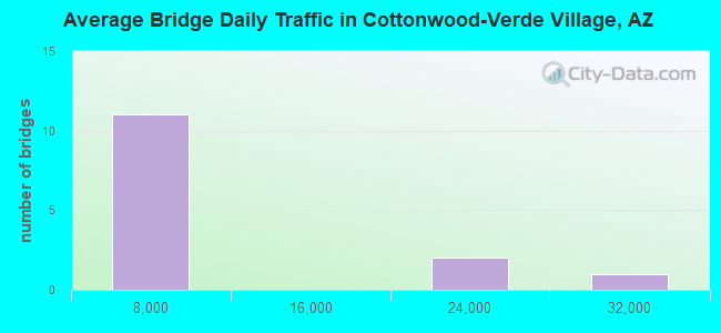
- 70,675Total average daily traffic
- 4,737Total average daily truck traffic
- 70,815Total future (year 2037) average daily traffic
- National Bridge Inventory (NBI) Registered Bridges for Cottonwood-Verde Village
- No street view available for this location
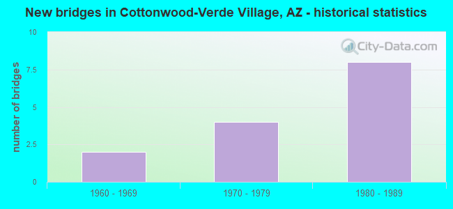
- New bridges - historical statistics
- 21960-1969
- 41970-1979
- 81980-1989
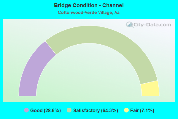
- Bridge Condition - Channel
- 28.6%Good
- 64.3%Satisfactory
- 7.1%Fair
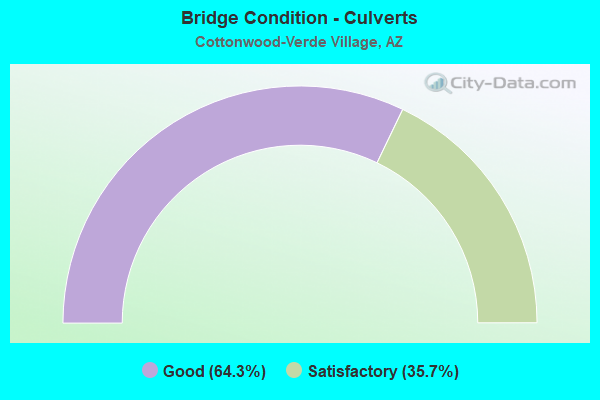
- Bridge Condition - Culverts
- 64.3%Good
- 35.7%Satisfactory
Find on map >> Show street view
Structure Number: 512, Location: 10.7 mi N Jct I 17 (Lat: 34.702400, Lng: -111.989300), Route carried "on" structure: State highway 260, Year Built: 1962, Year Reconstructed: 1997, Status: Open, Structure Length: 0.98m (3.22ft), Average Daily Traffic: 20,676 (year 2017), Truck Traffic: 8%, Average Future Daily Traffic: 20,686 (year 2037), Design Load: HS 20, Features Intersected: Wash
Minimum Vertical Clearance: 30+ m (98+ ft), Kilometerpoint: 334.840, Lanes on structure: 4, Owner: State Highway Agency, Approaching Roadway Width: 22.9m (75.1ft), Material/Design: Concrete continuous, Design/Construction: Culvert, Number Of Spans In Main Unit: 3, Length of Maximum Span: 3.0m (9.8ft), Curb or Sidewalk Widths: Left: 1.7m (5.6ft), Right: 0.0m
Condition: Channel: Good, Culverts: Satisfactory, Operating Rating: 89.8 metric tons, Method Used To Determine Operating Rating: Load Factor (LF), Inventory Rating: 68.9 metric tons, Method Used To Determine Inventory Rating: Load Factor (LF), Structural Evaluation: Equal to present minimum criteria, Waterway Adequacy: Equal to present desirable criteria, Approach Roadway Alignment: Equal to present desirable criteria, Length Of Structure Improvement: 1.74m (5.71ft), Designated Inspection Frequency: Every 48 months, Inspection Date: July 2018, Total Project Cost: $1,000
Find on map >> Show street view
Structure Number: 5121, Location: 1.2 mi SE Jct SR 89A (Lat: 34.707500, Lng: -111.993200), Route carried "on" structure: State highway 260, Year Built: 1962, Year Reconstructed: 1997, Status: Open, Structure Length: 1.31m (4.30ft), Average Daily Traffic: 26,538 (year 2017), Truck Traffic: 6%, Average Future Daily Traffic: 26,548 (year 2037), Design Load: HS 20, Features Intersected: Wash
Minimum Vertical Clearance: 30+ m (98+ ft), Kilometerpoint: 334.196, Lanes on structure: 4, Owner: State Highway Agency, Approaching Roadway Width: 22.9m (75.1ft), Material/Design: Concrete continuous, Design/Construction: Culvert, Number Of Spans In Main Unit: 4, Length of Maximum Span: 3.0m (9.8ft)
Condition: Channel: Good, Culverts: Good, Operating Rating: 89.8 metric tons, Method Used To Determine Operating Rating: Load Factor (LF), Inventory Rating: 76.2 metric tons, Method Used To Determine Inventory Rating: Load Factor (LF), Structural Evaluation: Better than present minimum criteria, Waterway Adequacy: Equal to present desirable criteria, Approach Roadway Alignment: Better than present minimum criteria, Length Of Structure Improvement: 2.07m (6.79ft), Designated Inspection Frequency: Every 48 months, Inspection Date: September 2018, Bridge Improvement Cost: $1,000, Total Project Cost: $2,000 ( Estimate for 2014)
Find on map >> Show street view
Structure Number: 6817, Location: 0.5 mi NE of Jct SR 260 (Lat: 34.720900, Lng: -111.992200), Route carried "on" structure: Alternate State highway 89, Year Built: 1971, Status: Open, Structure Length: 0.64m (2.10ft), Average Daily Traffic: 20,991 (year 2019), Truck Traffic: 7%, Average Future Daily Traffic: 21,001 (year 2039), Design Load: HS 20, Features Intersected: Oak Wash
Minimum Vertical Clearance: 30+ m (98+ ft), Kilometerpoint: 572.760, Lanes on structure: 2, Owner: State Highway Agency, Approaching Roadway Width: 7.9m (25.9ft), Material/Design: Concrete continuous, Design/Construction: Culvert, Number Of Spans In Main Unit: 2, Length of Maximum Span: 3.0m (9.8ft)
Condition: Channel: Satisfactory, Culverts: Good, Operating Rating: 89.8 metric tons, Method Used To Determine Operating Rating: Load Factor (LF), Inventory Rating: 89.8 metric tons, Method Used To Determine Inventory Rating: Load Factor (LF), Structural Evaluation: Better than present minimum criteria, Waterway Adequacy: Better than present minimum criteria, Approach Roadway Alignment: Better than present minimum criteria, Designated Inspection Frequency: Every 48 months, Inspection Date: August 2021
Find on map >> Show street view
Structure Number: 10734, Location: 0.1 mi N Jct Mdlark Ln (Lat: 34.701889, Lng: -112.012278), Route carried "on" structure: County highway , Year Built: 1980, Status: Open, Structure Length: 0.64m (2.10ft), Average Daily Traffic: 310 (year 2018), Truck Traffic: 1%, Average Future Daily Traffic: 320 (year 2039), Design Load: HS 20, Features Intersected: Christina Draw, Facility Carried by Structure: Arroya Vista Dr
Minimum Vertical Clearance: 30+ m (98+ ft), Kilometerpoint: 0.000, Lanes on structure: 2, Owner: County Highway Agency, Approaching Roadway Width: 7.3m (24.0ft), Material/Design: Steel, Design/Construction: Culvert, Number Of Spans In Main Unit: 3, Length of Maximum Span: 1.8m (5.9ft)
Condition: Channel: Good, Culverts: Satisfactory, Operating Rating: 64.4 metric tons, Method Used To Determine Operating Rating: Load Factor (LF), Inventory Rating: 37.2 metric tons, Method Used To Determine Inventory Rating: Load Factor (LF), Structural Evaluation: Equal to present minimum criteria, Waterway Adequacy: Equal to present minimum criteria, Approach Roadway Alignment: Equal to present minimum criteria, Designated Inspection Frequency: Every 48 months, Inspection Date: August 2019
Find on map >> Show street view
Structure Number: 10735, Location: 0.1 mi W of Arroya Vista (Lat: 34.701333, Lng: -112.014083), Route carried "on" structure: County highway , Year Built: 1980, Status: Open, Structure Length: 1.58m (5.18ft), Average Daily Traffic: 210 (year 2018), Truck Traffic: 1%, Average Future Daily Traffic: 220 (year 2039), Design Load: HS 20, Features Intersected: Christina Draw, Facility Carried by Structure: Brook Hollow Dr
Minimum Vertical Clearance: 30+ m (98+ ft), Kilometerpoint: 0.000, Lanes on structure: 2, Owner: County Highway Agency, Approaching Roadway Width: 6.4m (21.0ft), Skew: 4 degrees, Material/Design: Steel, Design/Construction: Culvert, Number Of Spans In Main Unit: 7, Length of Maximum Span: 1.2m (3.9ft)
Condition: Channel: Satisfactory, Culverts: Good, Operating Rating: 64.4 metric tons, Method Used To Determine Operating Rating: Load Factor (LF), Inventory Rating: 37.2 metric tons, Method Used To Determine Inventory Rating: Load Factor (LF), Structural Evaluation: Better than present minimum criteria, Waterway Adequacy: Equal to present minimum criteria, Approach Roadway Alignment: Better than present minimum criteria, Designated Inspection Frequency: Every 48 months, Inspection Date: August 2019
Find on map >> Show street view
Structure Number: 10738, Location: W of Cayuse Trail (Lat: 34.707528, Lng: -111.983861), Route carried "on" structure: County highway , Year Built: 1987, Status: Open, Structure Length: 0.82m (2.69ft), Average Daily Traffic: 225 (year 2019), Truck Traffic: 1%, Average Future Daily Traffic: 235 (year 2039), Design Load: HS 20, Features Intersected: Wash, Facility Carried by Structure: Comanche Dr
Minimum Vertical Clearance: 30+ m (98+ ft), Kilometerpoint: 0.000, Lanes on structure: 2, Owner: County Highway Agency, Approaching Roadway Width: 6.7m (22.0ft), Material/Design: Steel, Design/Construction: Culvert, Number Of Spans In Main Unit: 4, Length of Maximum Span: 1.8m (5.9ft)
Condition: Channel: Satisfactory, Culverts: Good, Operating Rating: 64.4 metric tons, Method Used To Determine Operating Rating: Load Factor (LF), Inventory Rating: 37.2 metric tons, Method Used To Determine Inventory Rating: Load Factor (LF), Structural Evaluation: Better than present minimum criteria, Waterway Adequacy: Equal to present minimum criteria, Approach Roadway Alignment: Equal to present desirable criteria, Designated Inspection Frequency: Every 48 months, Inspection Date: September 2019
Find on map >> Show street view
Structure Number: 1074, Location: S of int w/ Dobbin Trail (Lat: 34.716472, Lng: -112.012278), Route carried "on" structure: County highway , Year Built: 1973, Status: Open, Structure Length: 0.64m (2.10ft), Average Daily Traffic: 225 (year 2019), Truck Traffic: 1%, Average Future Daily Traffic: 235 (year 2039), Design Load: HS 20, Features Intersected: Oak Wash, Facility Carried by Structure: Gold Dust Circle
Minimum Vertical Clearance: 30+ m (98+ ft), Kilometerpoint: 0.000, Lanes on structure: 2, Owner: County Highway Agency, Approaching Roadway Width: 9.1m (29.9ft), Material/Design: Concrete continuous, Design/Construction: Culvert, Number Of Spans In Main Unit: 2, Length of Maximum Span: 3.0m (9.8ft), Curb-To-Curb Width: 9.1m (29.9ft), Out-to-Out Width: 9.8m (32.2ft)
Condition: Channel: Satisfactory, Culverts: Satisfactory, Operating Rating: 54.4 metric tons, Method Used To Determine Operating Rating: Load Factor (LF), Inventory Rating: 32.7 metric tons, Method Used To Determine Inventory Rating: Load Factor (LF), Structural Evaluation: Equal to present minimum criteria, Deck Geometry: Equal to present minimum criteria, Waterway Adequacy: Better than present minimum criteria, Approach Roadway Alignment: Better than present minimum criteria, Designated Inspection Frequency: Every 48 months, Inspection Date: September 2019, Deck Structure Type: Concrete Cast-file-Place, Wearing Surface/Protective System: Wearing Surface: Monolithic Concrete
Find on map >> Show street view
Structure Number: 10741, Location: S of int w/ Dobbin Trail (Lat: 34.716083, Lng: -112.014083), Route carried "on" structure: County highway , Year Built: 1973, Status: Open, Structure Length: 0.64m (2.10ft), Average Daily Traffic: 75 (year 2018), Average Future Daily Traffic: 85 (year 2039), Design Load: HS 20, Features Intersected: Oak Wash, Facility Carried by Structure: Verde Dr
Minimum Vertical Clearance: 30+ m (98+ ft), Kilometerpoint: 0.000, Lanes on structure: 2, Owner: County Highway Agency, Approaching Roadway Width: 8.8m (28.9ft), Skew: 1 degrees, Material/Design: Concrete continuous, Design/Construction: Culvert, Number Of Spans In Main Unit: 2, Length of Maximum Span: 3.0m (9.8ft), Curb-To-Curb Width: 8.8m (28.9ft), Out-to-Out Width: 9.4m (30.8ft)
Condition: Channel: Satisfactory, Culverts: Good, Operating Rating: 54.4 metric tons, Method Used To Determine Operating Rating: Load Factor (LF), Inventory Rating: 32.7 metric tons, Method Used To Determine Inventory Rating: Load Factor (LF), Structural Evaluation: Better than present minimum criteria, Deck Geometry: Better than present minimum criteria, Waterway Adequacy: Better than present minimum criteria, Approach Roadway Alignment: Better than present minimum criteria, Designated Inspection Frequency: Every 48 months, Inspection Date: August 2019, Deck Structure Type: Concrete Cast-file-Place, Wearing Surface/Protective System: Wearing Surface: Bituminous
Find on map >> Show street view
Structure Number: 10743, Location: S of int. w/ Dobbin Trail (Lat: 34.716306, Lng: -112.013194), Route carried "on" structure: County highway , Year Built: 1973, Status: Open, Structure Length: 0.64m (2.10ft), Average Daily Traffic: 210 (year 2018), Truck Traffic: 1%, Average Future Daily Traffic: 220 (year 2039), Design Load: HS 20, Features Intersected: Oak Wash, Facility Carried by Structure: Wild Burro Dr
Minimum Vertical Clearance: 30+ m (98+ ft), Kilometerpoint: 0.000, Lanes on structure: 2, Owner: County Highway Agency, Approaching Roadway Width: 9.1m (29.9ft), Skew: 1 degrees, Material/Design: Concrete continuous, Design/Construction: Culvert, Number Of Spans In Main Unit: 2, Length of Maximum Span: 3.0m (9.8ft), Curb or Sidewalk Widths: Left: 0.3m (1.0ft), Right: 0.3m (1.0ft), Curb-To-Curb Width: 9.1m (29.9ft), Out-to-Out Width: 9.7m (31.8ft)
Condition: Channel: Satisfactory, Culverts: Good, Operating Rating: 54.4 metric tons, Method Used To Determine Operating Rating: Load Factor (LF), Inventory Rating: 32.7 metric tons, Method Used To Determine Inventory Rating: Load Factor (LF), Structural Evaluation: Better than present minimum criteria, Deck Geometry: Equal to present minimum criteria, Waterway Adequacy: Better than present minimum criteria, Approach Roadway Alignment: Better than present minimum criteria, Designated Inspection Frequency: Every 48 months, Inspection Date: August 2019, Deck Structure Type: Concrete Cast-file-Place, Wearing Surface/Protective System: Wearing Surface: Monolithic Concrete
Find on map >> Show street view
Structure Number: 10746, Location: 0.08 mi N /Rancho Vista (Lat: 34.715528, Lng: -112.030806), Route carried "on" structure: County highway , Year Built: 1980, Status: Open, Structure Length: 0.82m (2.69ft), Average Daily Traffic: 510 (year 2018), Truck Traffic: 1%, Average Future Daily Traffic: 520 (year 2039), Design Load: HS 20, Features Intersected: Oak Wash, Facility Carried by Structure: Monte Tesoro Dr
Minimum Vertical Clearance: 30+ m (98+ ft), Kilometerpoint: 0.000, Lanes on structure: 2, Owner: County Highway Agency, Approaching Roadway Width: 8.5m (27.9ft), Material/Design: Steel, Design/Construction: Culvert, Number Of Spans In Main Unit: 4, Length of Maximum Span: 1.8m (5.9ft)
Condition: Channel: Good, Culverts: Good, Operating Rating: 64.4 metric tons, Method Used To Determine Operating Rating: Load Factor (LF), Inventory Rating: 37.2 metric tons, Method Used To Determine Inventory Rating: Load Factor (LF), Structural Evaluation: Better than present minimum criteria, Waterway Adequacy: Better than present minimum criteria, Approach Roadway Alignment: Somewhat better than minimum adequacy, Designated Inspection Frequency: Every 48 months, Inspection Date: August 2019
Find on map >> Show street view
Structure Number: 10747, Location: 0.1 mi N /Rancho Vista Wy (Lat: 34.715444, Lng: -112.028583), Route carried "on" structure: County highway , Year Built: 1980, Status: Open, Structure Length: 0.82m (2.69ft), Average Daily Traffic: 210 (year 2018), Truck Traffic: 1%, Average Future Daily Traffic: 220 (year 2039), Design Load: HS 20, Features Intersected: Oak Wash, Facility Carried by Structure: Navajo Dr
Minimum Vertical Clearance: 30+ m (98+ ft), Kilometerpoint: 0.000, Lanes on structure: 2, Owner: County Highway Agency, Approaching Roadway Width: 7.3m (24.0ft), Skew: 1 degrees, Material/Design: Steel, Design/Construction: Culvert, Number Of Spans In Main Unit: 4, Length of Maximum Span: 1.8m (5.9ft)
Condition: Channel: Satisfactory, Culverts: Good, Operating Rating: 64.4 metric tons, Method Used To Determine Operating Rating: Load Factor (LF), Inventory Rating: 37.2 metric tons, Method Used To Determine Inventory Rating: Load Factor (LF), Structural Evaluation: Better than present minimum criteria, Waterway Adequacy: Better than present minimum criteria, Approach Roadway Alignment: Equal to present minimum criteria, Designated Inspection Frequency: Every 48 months, Inspection Date: August 2019
Find on map >> Show street view
Structure Number: 10748, Location: 0.08 mi N/Rancho Vista Wy (Lat: 34.715472, Lng: -112.029694), Route carried "on" structure: County highway , Year Built: 1980, Status: Open, Structure Length: 1.22m (4.00ft), Average Daily Traffic: 210 (year 2018), Truck Traffic: 1%, Average Future Daily Traffic: 220 (year 2039), Design Load: HS 20, Features Intersected: Oak Wash, Facility Carried by Structure: Ocotillo Dr
Minimum Vertical Clearance: 30+ m (98+ ft), Kilometerpoint: 0.000, Lanes on structure: 2, Owner: County Highway Agency, Approaching Roadway Width: 7.3m (24.0ft), Skew: 4 degrees, Material/Design: Steel, Design/Construction: Culvert, Number Of Spans In Main Unit: 4, Length of Maximum Span: 1.8m (5.9ft)
Condition: Channel: Satisfactory, Culverts: Satisfactory, Operating Rating: 52.6 metric tons, Method Used To Determine Operating Rating: Load Factor (LF), Inventory Rating: 29.9 metric tons, Method Used To Determine Inventory Rating: Load Factor (LF), Structural Evaluation: Equal to present minimum criteria, Waterway Adequacy: Better than present minimum criteria, Approach Roadway Alignment: Somewhat better than minimum adequacy, Designated Inspection Frequency: Every 48 months, Inspection Date: August 2019
Find on map >> Show street view
Structure Number: 10749, Location: 0.08 mi N of Rancho Vista (Lat: 34.715528, Lng: -112.032167), Route carried "on" structure: County highway , Year Built: 1980, Status: Open, Structure Length: 0.82m (2.69ft), Average Daily Traffic: 210 (year 2018), Truck Traffic: 1%, Average Future Daily Traffic: 220 (year 2039), Design Load: HS 20, Features Intersected: Oak Wash, Facility Carried by Structure: Pioneer Dr
Minimum Vertical Clearance: 30+ m (98+ ft), Kilometerpoint: 0.000, Lanes on structure: 2, Owner: County Highway Agency, Approaching Roadway Width: 7.6m (24.9ft), Material/Design: Steel, Design/Construction: Culvert, Number Of Spans In Main Unit: 4, Length of Maximum Span: 1.8m (5.9ft)
Condition: Channel: Satisfactory, Culverts: Satisfactory, Operating Rating: 64.4 metric tons, Method Used To Determine Operating Rating: Load Factor (LF), Inventory Rating: 37.2 metric tons, Method Used To Determine Inventory Rating: Load Factor (LF), Structural Evaluation: Equal to present minimum criteria, Waterway Adequacy: Better than present minimum criteria, Approach Roadway Alignment: Better than present minimum criteria, Designated Inspection Frequency: Every 48 months, Inspection Date: August 2019
Find on map >> Show street view
Structure Number: 10794, Location: 0.2 mi S of Fir St (Lat: 34.715306, Lng: -112.026639), Route carried "on" structure: County highway , Year Built: 1980, Status: Open, Structure Length: 1.16m (3.81ft), Average Daily Traffic: 75 (year 2018), Average Future Daily Traffic: 85 (year 2039), Design Load: HS 20, Features Intersected: Oak Wash, Facility Carried by Structure: Viejo Dr
Minimum Vertical Clearance: 30+ m (98+ ft), Kilometerpoint: 0.000, Lanes on structure: 2, Owner: County Highway Agency, Approaching Roadway Width: 8.2m (26.9ft), Skew: 4 degrees, Material/Design: Steel, Design/Construction: Culvert, Number Of Spans In Main Unit: 4, Length of Maximum Span: 1.8m (5.9ft)
Condition: Channel: Fair, Culverts: Good, Operating Rating: 64.4 metric tons, Method Used To Determine Operating Rating: Load Factor (LF), Inventory Rating: 37.2 metric tons, Method Used To Determine Inventory Rating: Load Factor (LF), Structural Evaluation: Better than present minimum criteria, Waterway Adequacy: Better than present minimum criteria, Approach Roadway Alignment: Equal to present minimum criteria, Designated Inspection Frequency: Every 48 months, Inspection Date: August 2019