Bridge Statistics for Crow Agency, Montana (MT)
Condition, Traffic, Stress, Structural Evaluation, Project Costs
- National Bridge Inventory (NBI) Statistics
- 25Number of bridges
- 223ft / 67.7mTotal length
- $1,722,000Total costs
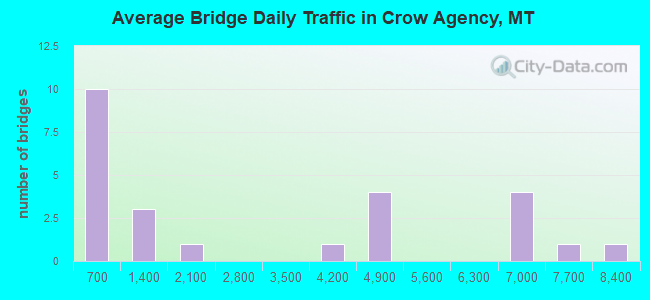
- 71,128Total average daily traffic
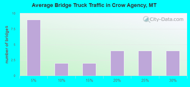
- 15,403Total average daily truck traffic
- National Bridge Inventory (NBI) Registered Bridges for Crow Agency
- No street view available for this location
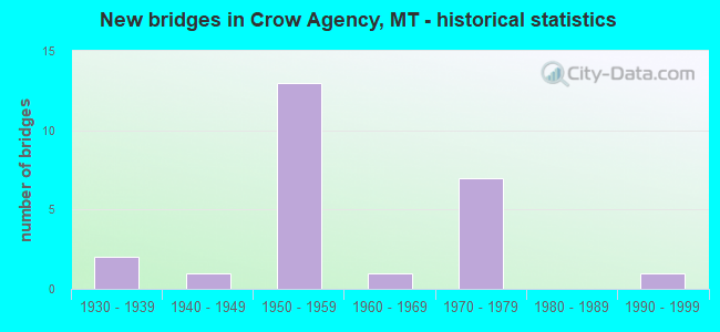
- New bridges - historical statistics
- 21930-1939
- 11940-1949
- 131950-1959
- 11960-1969
- 71970-1979
- 11990-1999
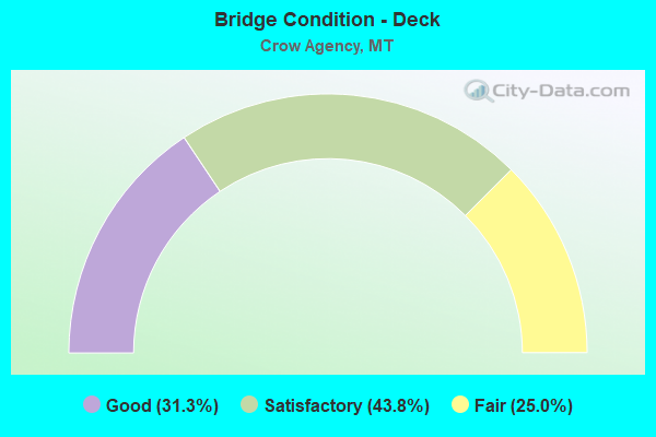
- Bridge Condition - Deck
- 31.3%Good
- 43.8%Satisfactory
- 25.0%Fair
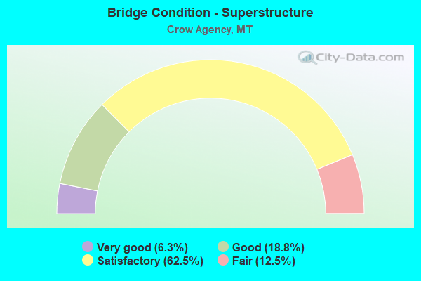
- Bridge Condition - Superstructure
- 6.3%Very good
- 18.8%Good
- 62.5%Satisfactory
- 12.5%Fair
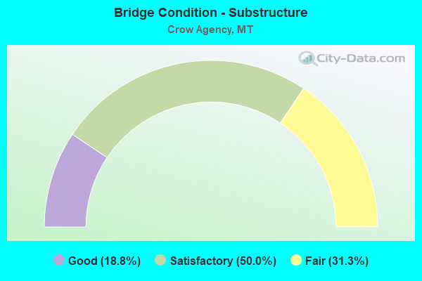
- Bridge Condition - Substructure
- 18.8%Good
- 50.0%Satisfactory
- 31.3%Fair
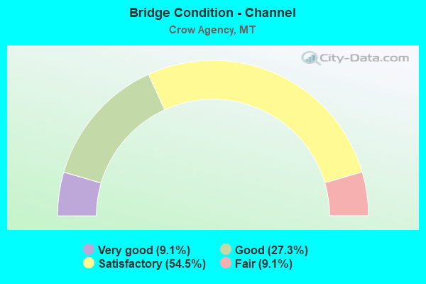
- Bridge Condition - Channel
- 9.1%Very good
- 27.3%Good
- 54.5%Satisfactory
- 9.1%Fair
Find on map >> Show street view
Structure Number: C202, Location: 7.2KM SOUTH OF CROW AGNCY (Lat: 45.549750, Lng: -107.437694), Route carried "on" structure: Federal lands road 14, Year Built: 1963, Status: Posted for load, Structure Length: 0.62m (2.03ft), Average Daily Traffic: 440 (year 2020), Truck Traffic: 10%, Average Future Daily Traffic: 515 (year 2040), Features Intersected: BIG SHOULDER CREEK
Minimum Vertical Clearance: 30+ m (98+ ft), Kilometerpoint: 0.200, Lanes on structure: 2, Owner: Bureau of Indian Affairs, Approaching Roadway Width: 7.3m (24.0ft), Skew: 2 degrees, Material/Design: Wood or Timber, Design/Construction: Stringer/Multi-beam, Number Of Spans In Main Unit: 1, Length of Maximum Span: 5.8m (19.0ft), Curb-To-Curb Width: 6.7m (22.0ft), Out-to-Out Width: 7.0m (23.0ft)
Condition: Deck: Fair, Superstructure: Fair, Substructure: Fair, Channel: Satisfactory, Operating Rating: 32.4 metric tons, Method Used To Determine Operating Rating: No rating analysis performed, Inventory Rating: 21.6 metric tons, Method Used To Determine Inventory Rating: No rating analysis performed, Structural Evaluation: Somewhat better than minimum adequacy, Deck Geometry: Meets minimum limits, Waterway Adequacy: Meets minimum limits, Approach Roadway Alignment: Equal to present minimum criteria, Bridge Posting: Required (Relationship of Operating Rating to Maximum Legal Load: 0.1 - 9.9% below), Designated Inspection Frequency: Every 24 months, Inspection Date: October 2020, Deck Structure Type: Wood or Timber, Wearing Surface/Protective System: Wearing Surface: Bituminous, Deck Protection: Other
Find on map >> Show street view
Structure Number: C226, Location: AT CROW AGENCY (Lat: 45.602972, Lng: -107.453694), Route carried "on" structure: Federal lands road 6, Year Built: 1999, Status: Open, Structure Length: 3.72m (12.20ft), Average Daily Traffic: 1,000 (year 2020), Truck Traffic: 10%, Average Future Daily Traffic: 1,170 (year 2040), Design Load: HS 20, Features Intersected: LITTLE BIGHORN RIVER
Minimum Vertical Clearance: 30+ m (98+ ft), Kilometerpoint: 0.100, Lanes on structure: 2, Owner: Bureau of Indian Affairs, Approaching Roadway Width: 9.2m (30.2ft), Material/Design: Prestressed concrete, Design/Construction: Tee Beam, Number Of Spans In Main Unit: 1, Length of Maximum Span: 36.0m (118.1ft), Curb or Sidewalk Widths: Left: 0.0m, Right: 2.0m (6.6ft), Curb-To-Curb Width: 9.2m (30.2ft), Out-to-Out Width: 11.9m (39.0ft)
Condition: Deck: Good, Superstructure: Very good, Substructure: Good, Channel: Fair, Operating Rating: 74.4 metric tons, Method Used To Determine Operating Rating: Load Factor (LF), Inventory Rating: 44.5 metric tons, Method Used To Determine Inventory Rating: Load Factor (LF), Structural Evaluation: Better than present minimum criteria, Deck Geometry: Equal to present minimum criteria, Waterway Adequacy: Better than present minimum criteria, Approach Roadway Alignment: Better than present minimum criteria, Designated Inspection Frequency: Every 24 months, Inspection Date: October 2020, Deck Structure Type: Concrete Precast Panels
Find on map >> Show street view
Structure Number: 1380001P, Location: I-90, EXIT 510, EAST ON U (Lat: 45.549361, Lng: -107.416194), Route carried "on" structure: Federal lands road 2100, Year Built: 1938, Status: Open, Structure Length: 0.67m (2.20ft), Average Daily Traffic: 100 (year 2019), Truck Traffic: 1%, Average Future Daily Traffic: 200 (year 2039), Design Load: H 20, Features Intersected: DEEP COULEE, Facility Carried by Structure: BATTLEFIELD ROAD
Minimum Vertical Clearance: 30+ m (98+ ft), Kilometerpoint: 0.000, Lanes on structure: 2, Owner: National Park Service, Approaching Roadway Width: 5.5m (18.0ft), Material/Design: Concrete continuous, Design/Construction: Culvert, Number Of Spans In Main Unit: 2, Length of Maximum Span: 3.0m (9.8ft)
Condition: Channel: Good, Culverts: Fair, Operating Rating: 32.7 metric tons, Method Used To Determine Operating Rating: Field evaluation and documented engineering judgment, Inventory Rating: 19.1 metric tons, Method Used To Determine Inventory Rating: Field evaluation and documented engineering judgment, Structural Evaluation: Somewhat better than minimum adequacy, Waterway Adequacy: Somewhat better than minimum adequacy, Approach Roadway Alignment: Equal to present desirable criteria, Designated Inspection Frequency: Every 24 months, Inspection Date: August 2021, Bridge Improvement Cost: $90,000, Roadway Improvement Cost: $9,000, Total Project Cost: $135,000 ( Estimate for 2021), Wearing Surface/Protective System: Wearing Surface: Bituminous
Find on map >> Show street view
Structure Number: 1380002P, Location: I-90, EXIT 510, EAST ON U (Lat: 45.548722, Lng: -107.412139), Route carried "on" structure: Federal lands road 2100, Year Built: 1938, Status: Open, Structure Length: 1.40m (4.59ft), Average Daily Traffic: 100 (year 2019), Truck Traffic: 1%, Average Future Daily Traffic: 200 (year 2039), Design Load: H 20, Features Intersected: MEDICINE TAIL COULEE, Facility Carried by Structure: BATTLEFIELD ROAD
Minimum Vertical Clearance: 30+ m (98+ ft), Kilometerpoint: 0.000, Lanes on structure: 2, Owner: National Park Service, Approaching Roadway Width: 5.5m (18.0ft), Skew: 1 degrees, Material/Design: Concrete continuous, Design/Construction: Culvert, Number Of Spans In Main Unit: 4, Length of Maximum Span: 3.4m (11.2ft)
Condition: Channel: Satisfactory, Culverts: Fair, Inventory Rating: 83.5 metric tons, Method Used To Determine Inventory Rating: Field evaluation and documented engineering judgment, Structural Evaluation: Somewhat better than minimum adequacy, Waterway Adequacy: Equal to present minimum criteria, Approach Roadway Alignment: Equal to present desirable criteria, Designated Inspection Frequency: Every 24 months, Inspection Date: August 2021, Bridge Improvement Cost: $190,000, Roadway Improvement Cost: $19,000, Total Project Cost: $285,000 ( Estimate for 2021), Wearing Surface/Protective System: Wearing Surface: Bituminous
Find on map >> Show street view
Structure Number: I00090503+02871, Location: 5.6M N CROW AGENCY (Lat: 45.680189, Lng: -107.504769), Route carried "on" structure: Interstate 90, Year Built: 1959, Status: Open, Structure Length: 3.63m (11.91ft), Average Daily Traffic: 7,822 (year 2020), Truck Traffic: 22%, Average Future Daily Traffic: 8,213 (year 2040), Design Load: HS 20, Features Intersected: INT DUNMORE
Minimum Vertical Clearance: 30+ m (98+ ft), Kilometerpoint: 806.320, Lanes on structure: 2, Lanes under structure: 2, Base Highway Network: Yes, Owner: State Highway Agency, Approaching Roadway Width: 11.6m (38.1ft), Material/Design: Prestressed concrete, Design/Construction: Stringer/Multi-beam, Number Of Spans In Main Unit: 3, Length of Maximum Span: 14.3m (46.9ft), Curb-To-Curb Width: 11.6m (38.1ft), Out-to-Out Width: 12.7m (41.7ft)
Condition: Deck: Good, Superstructure: Satisfactory, Substructure: Satisfactory, Operating Rating: 56.2 metric tons, Method Used To Determine Operating Rating: Load and Resistance Factor (LRFR), Inventory Rating: 41.7 metric tons, Method Used To Determine Inventory Rating: Load and Resistance Factor (LRFR), Structural Evaluation: Equal to present minimum criteria, Deck Geometry: Equal to present minimum criteria, Underclear: Meets minimum limits, Approach Roadway Alignment: Equal to present desirable criteria, Designated Inspection Frequency: Every 24 months, Inspection Date: October 2021, Deck Structure Type: Concrete Cast-file-Place, Wearing Surface/Protective System: Wearing Surface: Bituminous
Find on map >> Show street view
Structure Number: I00090503+02872, Location: 5.6M N CROW AGENCY (Lat: 45.680303, Lng: -107.504478), Route carried "on" structure: Interstate 90, Year Built: 1959, Status: Open, Structure Length: 3.63m (11.91ft), Average Daily Traffic: 7,483 (year 2020), Truck Traffic: 23%, Average Future Daily Traffic: 7,857 (year 2040), Design Load: HS 20, Features Intersected: INT DUNMORE
Minimum Vertical Clearance: 30+ m (98+ ft), Kilometerpoint: 806.711, Lanes on structure: 2, Lanes under structure: 2, Base Highway Network: Yes, Owner: State Highway Agency, Approaching Roadway Width: 11.6m (38.1ft), Material/Design: Prestressed concrete, Design/Construction: Stringer/Multi-beam, Number Of Spans In Main Unit: 3, Length of Maximum Span: 14.3m (46.9ft), Curb-To-Curb Width: 11.6m (38.1ft), Out-to-Out Width: 12.7m (41.7ft)
Condition: Deck: Good, Superstructure: Satisfactory, Substructure: Satisfactory, Operating Rating: 56.2 metric tons, Method Used To Determine Operating Rating: Load and Resistance Factor (LRFR), Inventory Rating: 41.7 metric tons, Method Used To Determine Inventory Rating: Load and Resistance Factor (LRFR), Structural Evaluation: Equal to present minimum criteria, Deck Geometry: Equal to present minimum criteria, Underclear: Meets minimum limits, Approach Roadway Alignment: Equal to present desirable criteria, Designated Inspection Frequency: Every 24 months, Inspection Date: October 2021, Deck Structure Type: Concrete Cast-file-Place, Wearing Surface/Protective System: Wearing Surface: Bituminous
Find on map >> Show street view
Structure Number: I00090509+02311, Location: CROW AGENCY (Lat: 45.601264, Lng: -107.462967), Route carried "on" structure: Interstate 90, Year Built: 1959, Status: Open, Structure Length: 4.08m (13.39ft), Average Daily Traffic: 6,965 (year 2020), Truck Traffic: 25%, Average Future Daily Traffic: 7,313 (year 2040), Design Load: HS 20, Features Intersected: INT CROW AGENCY
Minimum Vertical Clearance: 30+ m (98+ ft), Kilometerpoint: 815.881, Lanes on structure: 2, Lanes under structure: 2, Base Highway Network: Yes, Owner: State Highway Agency, Approaching Roadway Width: 11.6m (38.1ft), Material/Design: Prestressed concrete, Design/Construction: Stringer/Multi-beam, Number Of Spans In Main Unit: 3, Length of Maximum Span: 15.8m (51.8ft), Curb or Sidewalk Widths: Left: 0.1m (0.3ft), Right: 0.1m (0.3ft), Curb-To-Curb Width: 11.6m (38.1ft), Out-to-Out Width: 12.6m (41.3ft)
Condition: Deck: Fair, Superstructure: Fair, Substructure: Good, Operating Rating: 55.3 metric tons, Method Used To Determine Operating Rating: Load and Resistance Factor (LRFR), Inventory Rating: 35.4 metric tons, Method Used To Determine Inventory Rating: Load and Resistance Factor (LRFR), Structural Evaluation: Somewhat better than minimum adequacy, Deck Geometry: Equal to present minimum criteria, Underclear: Meets minimum limits, Approach Roadway Alignment: Equal to present desirable criteria, Designated Inspection Frequency: Every 24 months, Inspection Date: October 2020, Deck Structure Type: Concrete Cast-file-Place
Find on map >> Show street view
Structure Number: I00090509+02312, Location: CROW AGENCY (Lat: 45.601272, Lng: -107.462644), Route carried "on" structure: Interstate 90, Year Built: 1959, Status: Open, Structure Length: 4.08m (13.39ft), Average Daily Traffic: 6,965 (year 2020), Truck Traffic: 25%, Average Future Daily Traffic: 7,313 (year 2040), Design Load: HS 20, Features Intersected: INT CROW AGENCY
Minimum Vertical Clearance: 30+ m (98+ ft), Kilometerpoint: 816.286, Lanes on structure: 2, Lanes under structure: 2, Base Highway Network: Yes, Owner: State Highway Agency, Approaching Roadway Width: 11.6m (38.1ft), Material/Design: Prestressed concrete, Design/Construction: Stringer/Multi-beam, Number Of Spans In Main Unit: 3, Length of Maximum Span: 15.8m (51.8ft), Curb or Sidewalk Widths: Left: 0.1m (0.3ft), Right: 0.1m (0.3ft), Curb-To-Curb Width: 11.6m (38.1ft), Out-to-Out Width: 12.7m (41.7ft)
Condition: Deck: Fair, Superstructure: Good, Substructure: Satisfactory, Operating Rating: 59.0 metric tons, Method Used To Determine Operating Rating: Load and Resistance Factor (LRFR), Inventory Rating: 35.4 metric tons, Method Used To Determine Inventory Rating: Load and Resistance Factor (LRFR), Structural Evaluation: Equal to present minimum criteria, Deck Geometry: Equal to present minimum criteria, Underclear: Meets minimum limits, Approach Roadway Alignment: Equal to present desirable criteria, Designated Inspection Frequency: Every 24 months, Inspection Date: October 2020, Deck Structure Type: Concrete Cast-file-Place, Wearing Surface/Protective System: Wearing Surface: Bituminous
Find on map >> Show street view
Structure Number: I00090509+05611, Location: 0.6M S CROW AGENCY (Lat: 45.596586, Lng: -107.461847), Route carried "on" structure: Interstate 90, Year Built: 1949, Status: Open, Structure Length: 3.96m (12.99ft), Average Daily Traffic: 6,965 (year 2020), Truck Traffic: 25%, Average Future Daily Traffic: 7,313 (year 2040), Design Load: HS 20, Features Intersected: LITTLE BIGHORN RIVER
Minimum Vertical Clearance: 30+ m (98+ ft), Kilometerpoint: 816.411, Lanes on structure: 2, Base Highway Network: Yes, Owner: State Highway Agency, Approaching Roadway Width: 11.6m (38.1ft), Material/Design: Steel continuous, Design/Construction: Stringer/Multi-beam, Number Of Spans In Main Unit: 2, Length of Maximum Span: 20.1m (65.9ft), Curb or Sidewalk Widths: Left: 0.1m (0.3ft), Right: 0.1m (0.3ft), Curb-To-Curb Width: 8.5m (27.9ft), Out-to-Out Width: 10.4m (34.1ft)
Condition: Deck: Satisfactory, Superstructure: Satisfactory, Substructure: Satisfactory, Channel: Satisfactory, Operating Rating: 64.4 metric tons, Method Used To Determine Operating Rating: Load Factor (LF), Inventory Rating: 38.1 metric tons, Method Used To Determine Inventory Rating: Load Factor (LF), Structural Evaluation: Equal to present minimum criteria, Deck Geometry: High priority of replacement, Waterway Adequacy: Superior to present desirable criteria, Approach Roadway Alignment: Equal to present desirable criteria, Length Of Structure Improvement: 4.90m (16.08ft), Designated Inspection Frequency: Every 24 months, Inspection Date: July 2021, Bridge Improvement Cost: $264,000, Roadway Improvement Cost: $132,000, Total Project Cost: $396,000, Deck Structure Type: Concrete Cast-file-Place, Wearing Surface/Protective System: Wearing Surface: Monolithic Concrete
Find on map >> Show street view
Structure Number: I00090509+05612, Location: 0.6M S CROW AGENCY (Lat: 45.596633, Lng: -107.461614), Route carried "on" structure: Interstate 90, Year Built: 1959, Status: Open, Structure Length: 5.01m (16.44ft), Average Daily Traffic: 6,965 (year 2020), Truck Traffic: 25%, Average Future Daily Traffic: 7,313 (year 2040), Design Load: HS 20, Features Intersected: LITTLE BIGHORN RIVER
Minimum Vertical Clearance: 30+ m (98+ ft), Kilometerpoint: 816.810, Lanes on structure: 2, Base Highway Network: Yes, Owner: State Highway Agency, Approaching Roadway Width: 11.6m (38.1ft), Material/Design: Prestressed concrete, Design/Construction: Stringer/Multi-beam, Number Of Spans In Main Unit: 4, Length of Maximum Span: 15.8m (51.8ft), Curb-To-Curb Width: 8.5m (27.9ft), Out-to-Out Width: 9.7m (31.8ft)
Condition: Deck: Satisfactory, Superstructure: Satisfactory, Substructure: Satisfactory, Channel: Satisfactory, Operating Rating: 45.4 metric tons, Method Used To Determine Operating Rating: Load and Resistance Factor (LRFR), Inventory Rating: 26.3 metric tons, Method Used To Determine Inventory Rating: Load and Resistance Factor (LRFR), Structural Evaluation: Equal to present minimum criteria, Deck Geometry: High priority of replacement, Waterway Adequacy: Superior to present desirable criteria, Approach Roadway Alignment: Equal to present desirable criteria, Length Of Structure Improvement: 6.00m (19.69ft), Designated Inspection Frequency: Every 24 months, Inspection Date: July 2021, Bridge Improvement Cost: $310,000, Roadway Improvement Cost: $155,000, Total Project Cost: $465,000, Deck Structure Type: Concrete Cast-file-Place, Wearing Surface/Protective System: Wearing Surface: Monolithic Concrete
Find on map >> Show street view
Structure Number: I00090511+06051, Location: 2.5M S CROW AGENCY (Lat: 45.568308, Lng: -107.452219), Route carried "on" structure: Interstate 90, Year Built: 1956, Status: Open, Structure Length: 4.75m (15.58ft), Average Daily Traffic: 4,478 (year 2020), Truck Traffic: 19%, Average Future Daily Traffic: 4,702 (year 2040), Design Load: HS 20, Features Intersected: LITTLE BIGHORN RIVER
Minimum Vertical Clearance: 30+ m (98+ ft), Kilometerpoint: 819.704, Lanes on structure: 2, Base Highway Network: Yes, Owner: State Highway Agency, Approaching Roadway Width: 10.4m (34.1ft), Material/Design: Concrete continuous, Design/Construction: Tee Beam, Number Of Spans In Main Unit: 4, Length of Maximum Span: 18.3m (60.0ft), Curb or Sidewalk Widths: Left: 0.1m (0.3ft), Right: 0.1m (0.3ft), Curb-To-Curb Width: 8.5m (27.9ft), Out-to-Out Width: 9.7m (31.8ft)
Condition: Deck: Satisfactory, Superstructure: Satisfactory, Substructure: Good, Channel: Satisfactory, Operating Rating: 69.9 metric tons, Method Used To Determine Operating Rating: Load Factor (LF), Inventory Rating: 41.7 metric tons, Method Used To Determine Inventory Rating: Load Factor (LF), Structural Evaluation: Equal to present minimum criteria, Deck Geometry: High priority of replacement, Waterway Adequacy: Superior to present desirable criteria, Approach Roadway Alignment: Equal to present desirable criteria, Length Of Structure Improvement: 5.80m (19.03ft), Designated Inspection Frequency: Every 24 months, Inspection Date: July 2021, Bridge Improvement Cost: $294,000, Roadway Improvement Cost: $147,000, Total Project Cost: $441,000
Find on map >> Show street view
Structure Number: I00090511+06052, Location: 2.5M S CROW AGENCY (Lat: 45.568383, Lng: -107.452019), Route carried "on" structure: Interstate 90, Year Built: 1976, Status: Open, Structure Length: 4.92m (16.14ft), Average Daily Traffic: 4,478 (year 2020), Truck Traffic: 19%, Average Future Daily Traffic: 4,702 (year 2040), Design Load: HS 20, Features Intersected: LITTLE BIGHORN RIVER
Minimum Vertical Clearance: 30+ m (98+ ft), Kilometerpoint: 820.097, Lanes on structure: 2, Base Highway Network: Yes, Owner: State Highway Agency, Approaching Roadway Width: 11.6m (38.1ft), Skew: 1 degrees, Material/Design: Prestressed concrete, Design/Construction: Stringer/Multi-beam, Number Of Spans In Main Unit: 2, Length of Maximum Span: 24.7m (81.0ft), Curb-To-Curb Width: 12.6m (41.3ft), Out-to-Out Width: 13.5m (44.3ft)
Condition: Deck: Satisfactory, Superstructure: Satisfactory, Substructure: Fair, Channel: Good, Operating Rating: 53.5 metric tons, Method Used To Determine Operating Rating: Load and Resistance Factor (LRFR), Inventory Rating: 25.4 metric tons, Method Used To Determine Inventory Rating: Load and Resistance Factor (LRFR), Structural Evaluation: Somewhat better than minimum adequacy, Deck Geometry: Better than present minimum criteria, Waterway Adequacy: Superior to present desirable criteria, Approach Roadway Alignment: Equal to present desirable criteria, Designated Inspection Frequency: Every 24 months, Inspection Date: July 2021, Deck Structure Type: Concrete Cast-file-Place, Wearing Surface/Protective System: Wearing Surface: Monolithic Concrete
Find on map >> Show street view
Structure Number: I00090514+07721, Location: 5.6M S CROW AGENCY (Lat: 45.528903, Lng: -107.420039), Route carried "on" structure: Interstate 90, Year Built: 1976, Status: Open, Structure Length: 3.08m (10.10ft), Average Daily Traffic: 4,478 (year 2020), Truck Traffic: 19%, Average Future Daily Traffic: 4,702 (year 2040), Design Load: HS 20, Features Intersected: INT GARRYOWEN
Minimum Vertical Clearance: 30+ m (98+ ft), Kilometerpoint: 824.787, Lanes on structure: 2, Lanes under structure: 2, Base Highway Network: Yes, Owner: State Highway Agency, Approaching Roadway Width: 11.6m (38.1ft), Material/Design: Prestressed concrete, Design/Construction: Stringer/Multi-beam, Number Of Spans In Main Unit: 1, Length of Maximum Span: 30.5m (100.1ft), Curb or Sidewalk Widths: Left: 0.1m (0.3ft), Right: 0.1m (0.3ft), Curb-To-Curb Width: 12.6m (41.3ft), Out-to-Out Width: 13.5m (44.3ft)
Condition: Deck: Satisfactory, Superstructure: Satisfactory, Substructure: Fair, Operating Rating: 45.4 metric tons, Method Used To Determine Operating Rating: Load and Resistance Factor (LRFR), Inventory Rating: 20.9 metric tons, Method Used To Determine Inventory Rating: Load and Resistance Factor (LRFR), Structural Evaluation: Somewhat better than minimum adequacy, Deck Geometry: Better than present minimum criteria, Underclear: Better than present minimum criteria, Approach Roadway Alignment: Equal to present desirable criteria, Designated Inspection Frequency: Every 24 months, Inspection Date: October 2020, Deck Structure Type: Concrete Cast-file-Place, Wearing Surface/Protective System: Wearing Surface: Monolithic Concrete
Find on map >> Show street view
Structure Number: I00090514+07722, Location: 5.6M S CROW AGENCY (Lat: 45.529011, Lng: -107.419794), Route carried "on" structure: Interstate 90, Year Built: 1976, Status: Open, Structure Length: 3.08m (10.10ft), Average Daily Traffic: 3,837 (year 2020), Truck Traffic: 22%, Average Future Daily Traffic: 4,029 (year 2040), Design Load: HS 20, Features Intersected: INT GARRYOWEN
Minimum Vertical Clearance: 30+ m (98+ ft), Kilometerpoint: 825.177, Lanes on structure: 2, Lanes under structure: 2, Base Highway Network: Yes, Owner: State Highway Agency, Approaching Roadway Width: 11.6m (38.1ft), Material/Design: Prestressed concrete, Design/Construction: Stringer/Multi-beam, Number Of Spans In Main Unit: 1, Length of Maximum Span: 30.5m (100.1ft), Curb or Sidewalk Widths: Left: 0.1m (0.3ft), Right: 0.1m (0.3ft), Curb-To-Curb Width: 12.6m (41.3ft), Out-to-Out Width: 13.5m (44.3ft)
Condition: Deck: Satisfactory, Superstructure: Satisfactory, Substructure: Fair, Operating Rating: 48.1 metric tons, Method Used To Determine Operating Rating: Load and Resistance Factor (LRFR), Inventory Rating: 20.0 metric tons, Method Used To Determine Inventory Rating: Load and Resistance Factor (LRFR), Structural Evaluation: Somewhat better than minimum adequacy, Deck Geometry: Better than present minimum criteria, Underclear: Better than present minimum criteria, Approach Roadway Alignment: Equal to present desirable criteria, Designated Inspection Frequency: Every 24 months, Inspection Date: October 2020, Deck Structure Type: Concrete Cast-file-Place, Wearing Surface/Protective System: Wearing Surface: Monolithic Concrete
Find on map >> Show street view
Structure Number: L02046011+03001, Location: CROW AGENCY (Lat: 45.597178, Lng: -107.459825), Route carried "on" structure: ServiceState highway 2046, Year Built: 1958, Status: Open, Structure Length: 4.72m (15.49ft), Average Daily Traffic: 100 (year 2022), Truck Traffic: 3%, Average Future Daily Traffic: 100 (year 2037), Design Load: HS 15, Features Intersected: LITTLE BIGHORN RIVER 069, Facility Carried by Structure: BALA ST
Minimum Vertical Clearance: 30+ m (98+ ft), Kilometerpoint: 2.444, Lanes on structure: 2, Owner: State Highway Agency, Approaching Roadway Width: 8.5m (27.9ft), Material/Design: Prestressed concrete, Design/Construction: Stringer/Multi-beam, Number Of Spans In Main Unit: 3, Length of Maximum Span: 15.8m (51.8ft), Curb or Sidewalk Widths: Left: 0.5m (1.6ft), Right: 0.5m (1.6ft), Curb-To-Curb Width: 7.3m (24.0ft), Out-to-Out Width: 8.4m (27.6ft)
Condition: Deck: Good, Superstructure: Good, Substructure: Satisfactory, Channel: Good, Operating Rating: 31.8 metric tons, Method Used To Determine Operating Rating: Load and Resistance Factor (LRFR), Inventory Rating: 20.0 metric tons, Method Used To Determine Inventory Rating: Load and Resistance Factor (LRFR), Structural Evaluation: Somewhat better than minimum adequacy, Deck Geometry: Equal to present minimum criteria, Waterway Adequacy: Equal to present desirable criteria, Approach Roadway Alignment: Better than present minimum criteria, Designated Inspection Frequency: Every 24 months, Inspection Date: May 2020, Deck Structure Type: Concrete Cast-file-Place, Wearing Surface/Protective System: Wearing Surface: Monolithic Concrete
Find on map >> Show street view
Structure Number: L02315003+02001, Location: 2M S CROW AGENCY (Lat: 45.568217, Lng: -107.452608), Route carried "on" structure: ServiceState highway 2315, Year Built: 1976, Status: Open, Structure Length: 4.97m (16.31ft), Average Daily Traffic: 100 (year 2022), Truck Traffic: 3%, Average Future Daily Traffic: 100 (year 2037), Design Load: HS 20, Features Intersected: LITTLE BIGHORN RIVER 002, Facility Carried by Structure: IRR - FRONTAGE 315
Minimum Vertical Clearance: 30+ m (98+ ft), Kilometerpoint: 5.095, Lanes on structure: 2, Owner: State Highway Agency, Approaching Roadway Width: 9.4m (30.8ft), Skew: 1 degrees, Material/Design: Prestressed concrete, Design/Construction: Stringer/Multi-beam, Number Of Spans In Main Unit: 2, Length of Maximum Span: 24.6m (80.7ft), Curb or Sidewalk Widths: Left: 0.1m (0.3ft), Right: 0.1m (0.3ft), Curb-To-Curb Width: 8.4m (27.6ft), Out-to-Out Width: 9.2m (30.2ft)
Condition: Deck: Satisfactory, Superstructure: Satisfactory, Substructure: Fair, Channel: Very good, Operating Rating: 49.0 metric tons, Method Used To Determine Operating Rating: Load and Resistance Factor (LRFR), Inventory Rating: 29.0 metric tons, Method Used To Determine Inventory Rating: Load and Resistance Factor (LRFR), Structural Evaluation: Somewhat better than minimum adequacy, Deck Geometry: Equal to present minimum criteria, Waterway Adequacy: Superior to present desirable criteria, Approach Roadway Alignment: Equal to present desirable criteria, Designated Inspection Frequency: Every 24 months, Inspection Date: September 2021, Deck Structure Type: Concrete Cast-file-Place, Wearing Surface/Protective System: Wearing Surface: Monolithic Concrete
Find on map >> Show street view
Structure Number: L02325000+09001, Location: 2M S CROW AGENCY (Lat: 45.568478, Lng: -107.451692), Route carried "on" structure: ServiceState highway 2325, Year Built: 1976, Status: Open, Structure Length: 4.97m (16.31ft), Average Daily Traffic: 100 (year 2022), Truck Traffic: 3%, Average Future Daily Traffic: 100 (year 2037), Design Load: HS 20, Features Intersected: LITTLE BIGHORN RIVER 075, Facility Carried by Structure: IRR - FRONTAGE 325
Minimum Vertical Clearance: 30+ m (98+ ft), Kilometerpoint: 1.313, Lanes on structure: 2, Owner: State Highway Agency, Approaching Roadway Width: 8.5m (27.9ft), Skew: 1 degrees, Material/Design: Prestressed concrete, Design/Construction: Stringer/Multi-beam, Number Of Spans In Main Unit: 2, Length of Maximum Span: 24.6m (80.7ft), Curb or Sidewalk Widths: Left: 0.1m (0.3ft), Right: 0.1m (0.3ft), Curb-To-Curb Width: 9.6m (31.5ft), Out-to-Out Width: 10.4m (34.1ft)
Condition: Deck: Good, Superstructure: Good, Substructure: Satisfactory, Channel: Satisfactory, Operating Rating: 57.2 metric tons, Method Used To Determine Operating Rating: Load and Resistance Factor (LRFR), Inventory Rating: 41.7 metric tons, Method Used To Determine Inventory Rating: Load and Resistance Factor (LRFR), Structural Evaluation: Equal to present minimum criteria, Deck Geometry: Better than present minimum criteria, Waterway Adequacy: Superior to present desirable criteria, Approach Roadway Alignment: Equal to present desirable criteria, Designated Inspection Frequency: Every 48 months, Inspection Date: September 2021, Deck Structure Type: Concrete Cast-file-Place, Wearing Surface/Protective System: Wearing Surface: Monolithic Concrete
Find on map >> Show street view
Structure Number: P00037000+00001, Location: 1M S CROW AGENCY (Lat: 45.578542, Lng: -107.452886), Route carried "on" structure: US 212, Year Built: 1959, Status: Open, Structure Length: 6.37m (20.90ft), Average Daily Traffic: 2,094 (year 2020), Truck Traffic: 23%, Average Future Daily Traffic: 2,272 (year 2040), Design Load: HS 20, Features Intersected: INT CUSTER BATLFLD I 90
Minimum Vertical Clearance: 30+ m (98+ ft), Kilometerpoint: 0.012, Lanes on structure: 2, Lanes under structure: 4, Base Highway Network: Yes, Owner: State Highway Agency, Approaching Roadway Width: 11.6m (38.1ft), Material/Design: Prestressed concrete, Design/Construction: Stringer/Multi-beam, Number Of Spans In Main Unit: 4, Length of Maximum Span: 18.9m (62.0ft), Curb or Sidewalk Widths: Left: 0.1m (0.3ft), Right: 0.1m (0.3ft), Curb-To-Curb Width: 8.5m (27.9ft), Out-to-Out Width: 9.7m (31.8ft)
Condition: Deck: Fair, Superstructure: Satisfactory, Substructure: Satisfactory, Operating Rating: 44.4 metric tons, Method Used To Determine Operating Rating: Assigned rating based on Load Factor Design (LFD) reported in metric tons, Inventory Rating: 32.7 metric tons, Method Used To Determine Inventory Rating: Assigned rating based on Load Factor Design (LFD) reported in metric tons, Structural Evaluation: Equal to present minimum criteria, Deck Geometry: Meets minimum limits, Underclear: High priority of corrective action, Approach Roadway Alignment: Better than present minimum criteria, Designated Inspection Frequency: Every 24 months, Inspection Date: October 2021, Deck Structure Type: Concrete Cast-file-Place, Wearing Surface/Protective System: Wearing Surface: Bituminous
Find on map >> Show street view
Structure Number: I00090503+02871, Location: 56M N CROW AGENCY (Lat: 45.680189, Lng: -107.504769), Route carried "under" structure: Spur County highway 2141, Year Built: 1959, Structure Length: 0. m, Average Daily Traffic: 100 (year 2022), Truck Traffic: 3%, Features Intersected: INT DUNMORE, Facility Carried by Structure: IRR - I 90
Minimum Vertical Clearance: 4.54m (14.90ft), Kilometerpoint: 11.197, Lanes on structure: 2, Lanes under structure: 2, Material/Design: Prestressed concrete, Design/Construction: Stringer/Multi-beam, Length of Maximum Span: 14.3m (46.9ft)
Find on map >> Show street view
Structure Number: I00090503+02872, Location: 56M N CROW AGENCY (Lat: 45.680303, Lng: -107.504478), Route carried "under" structure: ServiceCounty highway 2141, Year Built: 1959, Structure Length: 0. m, Average Daily Traffic: 100 (year 2022), Truck Traffic: 3%, Features Intersected: INT DUNMORE, Facility Carried by Structure: IRR - I 90
Minimum Vertical Clearance: 4.42m (14.50ft), Kilometerpoint: 11.171, Lanes on structure: 2, Lanes under structure: 2, Material/Design: Prestressed concrete, Design/Construction: Stringer/Multi-beam, Length of Maximum Span: 14.3m (46.9ft)
Find on map >> Show street view
Structure Number: I00090509+02311, Location: CROW AGENCY (Lat: 45.601264, Lng: -107.462967), Route carried "under" structure: ServiceCounty highway 2047, Year Built: 1959, Structure Length: 0. m, Average Daily Traffic: 100 (year 2022), Truck Traffic: 3%, Features Intersected: INT CROW AGENCY, Facility Carried by Structure: IRR - I 90
Minimum Vertical Clearance: 4.65m (15.26ft), Kilometerpoint: 16.902, Lanes on structure: 2, Lanes under structure: 2, Material/Design: Prestressed concrete, Design/Construction: Stringer/Multi-beam, Length of Maximum Span: 15.8m (51.8ft)
Find on map >> Show street view
Structure Number: I00090509+02312, Location: CROW AGENCY (Lat: 45.601272, Lng: -107.462644), Route carried "under" structure: ServiceCounty highway 2047, Year Built: 1959, Structure Length: 0. m, Average Daily Traffic: 100 (year 2022), Truck Traffic: 3%, Features Intersected: INT CROW AGENCY, Facility Carried by Structure: IRR - I 90
Minimum Vertical Clearance: 4.72m (15.49ft), Kilometerpoint: 16.927, Lanes on structure: 2, Lanes under structure: 2, Material/Design: Prestressed concrete, Design/Construction: Stringer/Multi-beam, Length of Maximum Span: 15.8m (51.8ft)
Find on map >> Show street view
Structure Number: I00090514+07721, Location: 56M S CROW AGENCY (Lat: 45.528903, Lng: -107.420039), Route carried "under" structure: State highway 451, Year Built: 1976, Structure Length: 0. m, Average Daily Traffic: 890 (year 2020), Truck Traffic: 6%, Features Intersected: INT GARRYOWEN, Facility Carried by Structure: IRR - I 90
Minimum Vertical Clearance: 5.10m (16.73ft), Kilometerpoint: 0.002, Lanes on structure: 2, Lanes under structure: 2, Material/Design: Prestressed concrete, Design/Construction: Stringer/Multi-beam, Length of Maximum Span: 30.5m (100.1ft)
Find on map >> Show street view
Structure Number: I00090514+07722, Location: 56M S CROW AGENCY (Lat: 45.529011, Lng: -107.419794), Route carried "under" structure: State highway 451, Year Built: 1976, Structure Length: 0. m, Average Daily Traffic: 890 (year 2020), Truck Traffic: 6%, Features Intersected: INT GARRYOWEN, Facility Carried by Structure: IRR - I 90
Minimum Vertical Clearance: 4.90m (16.08ft), Kilometerpoint: 0.000, Lanes on structure: 2, Lanes under structure: 2, Material/Design: Prestressed concrete, Design/Construction: Stringer/Multi-beam, Length of Maximum Span: 30.5m (100.1ft)
Find on map >> Show street view
Structure Number: P00037000+00001, Location: 1M S CROW AGENCY (Lat: 45.578542, Lng: -107.452886), Route carried "under" structure: Interstate 90, Year Built: 1959, Structure Length: 0. m, Average Daily Traffic: 4,478 (year 2020), Truck Traffic: 19%, Features Intersected: INT CUSTER BATLFLD I 90, Facility Carried by Structure: IRR - US 212
Minimum Vertical Clearance: 5.18m (16.99ft), Kilometerpoint: 818.554, Lanes on structure: 2, Lanes under structure: 4, Material/Design: Prestressed concrete, Design/Construction: Stringer/Multi-beam, Length of Maximum Span: 18.9m (62.0ft)