Bridge Statistics for Cumberland, Maryland (MD)
Condition, Traffic, Stress, Structural Evaluation, Project Costs
- National Bridge Inventory (NBI) Statistics
- 48Number of bridges
- 1,135ft / 346mTotal length
- $88,862,000Total costs
- 682,277Total average daily traffic
- 59,935Total average daily truck traffic
- National Bridge Inventory (NBI) Registered Bridges for Cumberland
- No street view available for this location
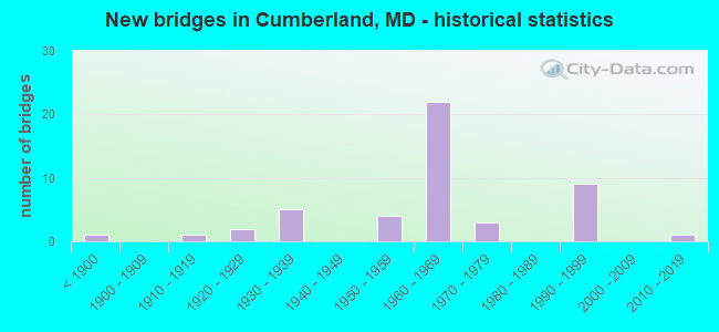
- New bridges - historical statistics
- 1Before 1900
- 11910-1919
- 21920-1929
- 51930-1939
- 41950-1959
- 221960-1969
- 31970-1979
- 91990-1999
- 12010-2019
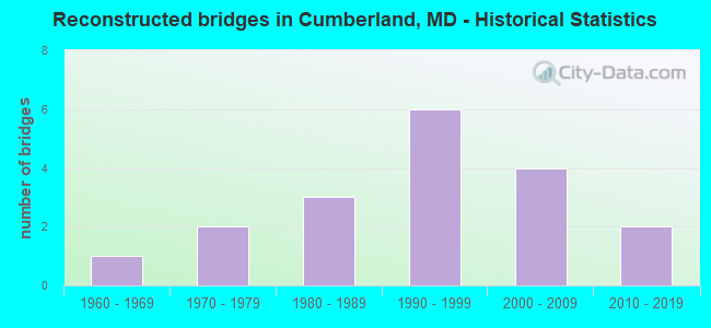
- Reconstructed bridges - Historical Statistics
- 11960-1969
- 21970-1979
- 31980-1989
- 61990-1999
- 42000-2009
- 22010-2019
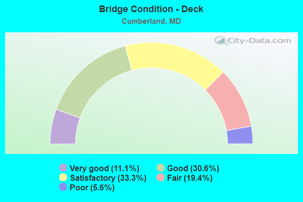
- Bridge Condition - Deck
- 11.1%Very good
- 30.6%Good
- 33.3%Satisfactory
- 19.4%Fair
- 5.6%Poor
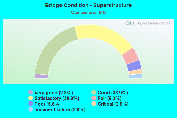
- Bridge Condition - Superstructure
- 2.8%Very good
- 38.9%Good
- 38.9%Satisfactory
- 8.3%Fair
- 5.6%Poor
- 2.8%Critical
- 2.8%Imminent failure
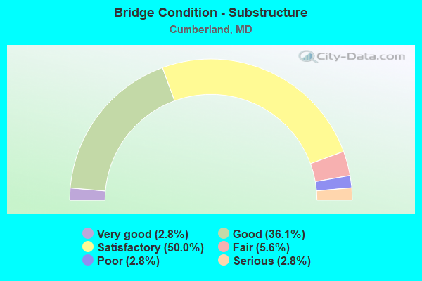
- Bridge Condition - Substructure
- 2.8%Very good
- 36.1%Good
- 50.0%Satisfactory
- 5.6%Fair
- 2.8%Poor
- 2.8%Serious
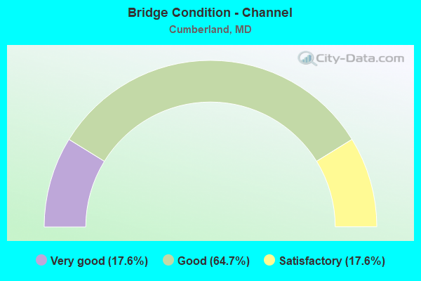
- Bridge Condition - Channel
- 17.6%Very good
- 64.7%Good
- 17.6%Satisfactory
Find on map >> Show street view
Structure Number: 10000001000502, Location: 0.07MI E OF MD 144 (Lat: 39.672858, Lng: -78.722639), Route carried "on" structure: Interstate 68, Year Built: 1938, Year Reconstructed: 1966, Status: Open, Structure Length: 0.78m (2.56ft), Average Daily Traffic: 26,680 (year 2009), Truck Traffic: 8%, Average Future Daily Traffic: 29,743 (year 2026), Design Load: HS 20, Features Intersected: BRANCH OF EVITTS CREEK
Minimum Vertical Clearance: 30+ m (98+ ft), Kilometerpoint: 24.666, Lanes on structure: 5, Base Highway Network: Yes, Owner: State Highway Agency, Approaching Roadway Width: 35.7m (117.1ft), Skew: 4 degrees, Material/Design: Concrete, Design/Construction: Culvert, Length of Maximum Span: 3.7m (12.1ft)
Condition: Channel: Satisfactory, Culverts: Satisfactory, Structural Evaluation: Equal to present minimum criteria, Waterway Adequacy: Meets minimum limits, Approach Roadway Alignment: Equal to present desirable criteria, Designated Inspection Frequency: Every 24 months, Inspection Date: January 2022
Find on map >> Show street view
Structure Number: 10000001002801, Location: 0.84 MI E OF MD 36 (Lat: 39.662783, Lng: -78.780956), Route carried "on" structure: Alternate US 40, Year Built: 1932, Year Reconstructed: 2000, Status: Open, Structure Length: 6.36m (20.87ft), Average Daily Traffic: 13,491 (year 2018), Truck Traffic: 8%, Average Future Daily Traffic: 13,504 (year 2038), Features Intersected: WILLS CREEK
Minimum Vertical Clearance: 30+ m (98+ ft), Kilometerpoint: 19.236, Lanes on structure: 2, Base Highway Network: Yes, Owner: State Highway Agency, Approaching Roadway Width: 12.8m (42.0ft), Skew: 5 degrees, Material/Design: Concrete, Design/Construction: Arch - Deck, Number Of Spans In Main Unit: 3, Length of Maximum Span: 20.4m (66.9ft), Curb or Sidewalk Widths: Left: 0.0m, Right: 0.9m (3.0ft), Curb-To-Curb Width: 8.9m (29.2ft), Out-to-Out Width: 10.8m (35.4ft)
Condition: Deck: Satisfactory, Superstructure: Satisfactory, Substructure: Satisfactory, Channel: Good, Inventory Rating: 75.3 metric tons, Method Used To Determine Inventory Rating: Load Factor (LF), Structural Evaluation: Equal to present minimum criteria, Deck Geometry: Meets minimum limits, Waterway Adequacy: Equal to present desirable criteria, Approach Roadway Alignment: Equal to present desirable criteria, Length Of Structure Improvement: 6.89m (22.60ft), Designated Inspection Frequency: Every 24 months, Inspection Date: June 2020, Bridge Improvement Cost: $480,000, Roadway Improvement Cost: $48,000, Total Project Cost: $528,000, Deck Structure Type: Concrete Cast-file-Place, Wearing Surface/Protective System: Wearing Surface: Bituminous
Find on map >> Show street view
Structure Number: 10000001003004, Location: 0.21 M E OF BR NO 0109900 (Lat: 39.673189, Lng: -78.723917), Route carried "on" structure: Interstate 68, Year Built: 1937, Year Reconstructed: 1990, Status: Open, Structure Length: 2.81m (9.22ft), Average Daily Traffic: 26,680 (year 2009), Truck Traffic: 5%, Average Future Daily Traffic: 29,743 (year 2026), Design Load: HS 20, Features Intersected: EVITTS CREEK
Minimum Vertical Clearance: 30+ m (98+ ft), Kilometerpoint: 24.891, Lanes on structure: 6, Base Highway Network: Yes, Owner: State Highway Agency, Approaching Roadway Width: 18.3m (60.0ft), Material/Design: Concrete continuous, Design/Construction: Frame, Number Of Spans In Main Unit: 2, Length of Maximum Span: 12.5m (41.0ft), Curb or Sidewalk Widths: Left: 3.3m (10.8ft), Right: 0.0m, Curb-To-Curb Width: 39.2m (128.6ft), Out-to-Out Width: 40.2m (131.9ft)
Condition: Deck: Satisfactory, Superstructure: Satisfactory, Substructure: Satisfactory, Channel: Good, Operating Rating: 64.4 metric tons, Method Used To Determine Operating Rating: Load Factor (LF), Inventory Rating: 38.5 metric tons, Method Used To Determine Inventory Rating: Load Factor (LF), Structural Evaluation: Equal to present minimum criteria, Deck Geometry: Superior to present desirable criteria, Waterway Adequacy: Meets minimum limits, Approach Roadway Alignment: Equal to present desirable criteria, Designated Inspection Frequency: Every 24 months, Inspection Date: July 2021, Deck Structure Type: Concrete Cast-file-Place, Wearing Surface/Protective System: Wearing Surface: Latex Concrete, Deck Protection: Cathodic Protection
Find on map >> Show street view
Structure Number: 10000001004401, Location: 0.14 MI E OF CUMBERLAND (Lat: 39.627114, Lng: -78.738119), Route carried "on" structure: State highway 51, Year Built: 1957, Year Reconstructed: 1990, Status: Open, Structure Length: 4.69m (15.39ft), Average Daily Traffic: 12,092 (year 2018), Truck Traffic: 10%, Average Future Daily Traffic: 12,093 (year 2038), Design Load: HS 20, Features Intersected: EVITTS CREEK
Minimum Vertical Clearance: 30+ m (98+ ft), Kilometerpoint: 4.442, Lanes on structure: 4, Base Highway Network: Yes, Owner: State Highway Agency, Approaching Roadway Width: 27.4m (89.9ft), Skew: 20 degrees, Material/Design: Prestressed concrete continuous, Design/Construction: Slab, Number Of Spans In Main Unit: 3, Length of Maximum Span: 15.2m (49.9ft), Curb-To-Curb Width: 26.5m (86.9ft), Out-to-Out Width: 27.5m (90.2ft)
Condition: Deck: Good, Superstructure: Good, Substructure: Good, Channel: Good, Operating Rating: 77.5 metric tons, Method Used To Determine Operating Rating: Load Factor (LF), Inventory Rating: 38.5 metric tons, Method Used To Determine Inventory Rating: Load Factor (LF), Structural Evaluation: Better than present minimum criteria, Deck Geometry: Superior to present desirable criteria, Waterway Adequacy: Meets minimum limits, Approach Roadway Alignment: Equal to present desirable criteria, Designated Inspection Frequency: Every 24 months, Inspection Date: May 2021, Deck Structure Type: Concrete Cast-file-Place, Wearing Surface/Protective System: Wearing Surface: Integral Concrete, Deck Protection: Epoxy Coated Reinforcing
Find on map >> Show street view
Structure Number: 10000001006501, Location: ON WEST VIRGINIA (Lat: 39.621850, Lng: -78.773631), Route carried "on" structure: State highway 61, Year Built: 1992, Status: Open, Structure Length: 13.29m (43.60ft), Average Daily Traffic: 11,501 (year 2009), Truck Traffic: 4%, Average Future Daily Traffic: 13,560 (year 2026), Design Load: HS 25 or greater, Features Intersected: NORTH BRANCH OF POTOMAC
Minimum Vertical Clearance: 30+ m (98+ ft), Kilometerpoint: 0.048, Lanes on structure: 2, Owner: State Highway Agency, Approaching Roadway Width: 17.1m (56.1ft), Material/Design: Steel continuous, Design/Construction: Stringer/Multi-beam, Number Of Spans In Main Unit: 3, Length of Maximum Span: 50.0m (164.0ft), Curb or Sidewalk Widths: Left: 0.0m, Right: 1.5m (4.9ft), Curb-To-Curb Width: 12.2m (40.0ft), Out-to-Out Width: 14.5m (47.6ft)
Condition: Deck: Good, Superstructure: Good, Substructure: Good, Channel: Good, Inventory Rating: 61.7 metric tons, Method Used To Determine Inventory Rating: Load Factor (LF), Structural Evaluation: Better than present minimum criteria, Deck Geometry: Somewhat better than minimum adequacy, Waterway Adequacy: Better than present minimum criteria, Approach Roadway Alignment: Equal to present desirable criteria, Designated Inspection Frequency: Every 24 months, Underwater Inspection Frequency: Every 48 months, Inspection Date: August 2020, Underwater Inspection Date: July 2018, Deck Structure Type: Concrete Cast-file-Place, Wearing Surface/Protective System: Wearing Surface: Integral Concrete, Deck Protection: Epoxy Coated Reinforcing
Find on map >> Show street view
Structure Number: 10000001006601, Location: ON WEST VIRGINIA LINE (Lat: 39.648675, Lng: -78.765789), Route carried "on" structure: State highway 942, Year Built: 1953, Year Reconstructed: 1996, Status: Open, Structure Length: 9.78m (32.09ft), Average Daily Traffic: 7,242 (year 2016), Truck Traffic: 8%, Average Future Daily Traffic: 8,000 (year 2036), Design Load: HS 20+Mod, Features Intersected: N BRANCH POTOMAC RIVER
Minimum Vertical Clearance: 30+ m (98+ ft), Kilometerpoint: 0.048, Lanes on structure: 2, Owner: State Highway Agency, Approaching Roadway Width: 11.6m (38.1ft), Material/Design: Steel, Design/Construction: Arch - Thru, Number Of Spans In Main Unit: 2, Length of Maximum Span: 47.5m (155.8ft), Curb or Sidewalk Widths: Left: 2.0m (6.6ft), Right: 2.0m (6.6ft), Curb-To-Curb Width: 8.5m (27.9ft), Out-to-Out Width: 12.4m (40.7ft)
Condition: Deck: Fair, Superstructure: Fair, Substructure: Satisfactory, Channel: Satisfactory, Operating Rating: 45.4 metric tons, Method Used To Determine Operating Rating: Load Factor (LF), Inventory Rating: 27.2 metric tons, Method Used To Determine Inventory Rating: Load Factor (LF), Structural Evaluation: Somewhat better than minimum adequacy, Deck Geometry: Meets minimum limits, Waterway Adequacy: Equal to present desirable criteria, Approach Roadway Alignment: Equal to present minimum criteria, Length Of Structure Improvement: 9.75m (31.99ft), Designated Inspection Frequency: Every 12 months, Critical Feature Inspection Frequency: Every 12 months, Underwater Inspection Frequency: Every 48 months, Inspection Date: November 2021, Critical Feature Inspection Date: November 2021, Underwater Inspection Date: May 2020, Bridge Improvement Cost: $1,670,000, Roadway Improvement Cost: $167,000, Total Project Cost: $1,837,000, Deck Structure Type: Concrete Cast-file-Place, Wearing Surface/Protective System: Wearing Surface: Bituminous
Find on map >> Show street view
Structure Number: 10000001008101, Location: 0.03 MI S OF MD 952A (Lat: 39.667067, Lng: -78.737028), Route carried "on" structure: ServiceState highway 952, Year Built: 1962, Year Reconstructed: 1993, Status: Open, Structure Length: 6.34m (20.80ft), Average Daily Traffic: 99 (year 2006), Truck Traffic: 8%, Average Future Daily Traffic: 200 (year 2026), Design Load: HS 20, Features Intersected: IS 68
Minimum Vertical Clearance: 30+ m (98+ ft), Kilometerpoint: 0.196, Lanes on structure: 2, Lanes under structure: 5, Owner: State Highway Agency, Approaching Roadway Width: 7.9m (25.9ft), Material/Design: Steel continuous, Design/Construction: Stringer/Multi-beam, Number Of Spans In Main Unit: 2, Length of Maximum Span: 31.1m (102.0ft), Curb-To-Curb Width: 8.5m (27.9ft), Out-to-Out Width: 9.8m (32.2ft)
Condition: Deck: Good, Superstructure: Good, Substructure: Good, Operating Rating: 83.9 metric tons, Method Used To Determine Operating Rating: Load Factor (LF), Inventory Rating: 50.3 metric tons, Method Used To Determine Inventory Rating: Load Factor (LF), Structural Evaluation: Better than present minimum criteria, Deck Geometry: Better than present minimum criteria, Underclear: Meets minimum limits, Approach Roadway Alignment: Equal to present minimum criteria, Designated Inspection Frequency: Every 24 months, Inspection Date: July 2021, Deck Structure Type: Concrete Cast-file-Place, Wearing Surface/Protective System: Wearing Surface: Monolithic Concrete, Deck Protection: Epoxy Coated Reinforcing
Find on map >> Show street view
Structure Number: 10000001009101, Location: 0.08 MILE EAST OF US 40AB (Lat: 39.672494, Lng: -78.723486), Route carried "on" structure: State highway 144, Year Built: 1966, Status: Open, Structure Length: 3.99m (13.09ft), Average Daily Traffic: 7,221 (year 2009), Truck Traffic: 8%, Average Future Daily Traffic: 8,649 (year 2026), Design Load: H 15, Features Intersected: EVITTS CREEK
Minimum Vertical Clearance: 30+ m (98+ ft), Kilometerpoint: 1.482, Lanes on structure: 2, Owner: State Highway Agency, Approaching Roadway Width: 9.8m (32.2ft), Material/Design: Steel, Design/Construction: Stringer/Multi-beam, Number Of Spans In Main Unit: 3, Length of Maximum Span: 16.2m (53.1ft), Curb-To-Curb Width: 8.0m (26.2ft), Out-to-Out Width: 9.6m (31.5ft)
Condition: Deck: Poor, Superstructure: Fair, Substructure: Satisfactory, Channel: Good, Operating Rating: 55.8 metric tons, Method Used To Determine Operating Rating: Load Factor (LF), Inventory Rating: 33.6 metric tons, Method Used To Determine Inventory Rating: Load Factor (LF), Structural Evaluation: Somewhat better than minimum adequacy, Deck Geometry: High priority of replacement, Waterway Adequacy: Superior to present desirable criteria, Approach Roadway Alignment: Equal to present minimum criteria, Length Of Structure Improvement: 3.99m (13.09ft), Designated Inspection Frequency: Every 12 months, Inspection Date: April 2021, Bridge Improvement Cost: $248,000, Roadway Improvement Cost: $25,000, Total Project Cost: $273,000, Deck Structure Type: Concrete Cast-file-Place, Wearing Surface/Protective System: Wearing Surface: Bituminous
Find on map >> Show street view
Structure Number: 10000001009201, Location: 0.40 MI E OF MD 51A (Lat: 39.642489, Lng: -78.763350), Route carried "on" structure: State highway 51, Year Built: 1965, Status: Open, Structure Length: 14.11m (46.29ft), Average Daily Traffic: 15,132 (year 2018), Truck Traffic: 9%, Average Future Daily Traffic: 15,133 (year 2038), Design Load: HS 20, Features Intersected: CSX TRANS., MD 61
Minimum Vertical Clearance: 30+ m (98+ ft), Kilometerpoint: 0.772, Lanes on structure: 4, Base Highway Network: Yes, Owner: State Highway Agency, Approaching Roadway Width: 21.9m (71.9ft), Skew: 24 degrees, Material/Design: Steel, Design/Construction: Stringer/Multi-beam, Number Of Spans In Main Unit: 2, Number Of Approach Spans: 3, Length of Maximum Span: 39.6m (129.9ft), Curb or Sidewalk Widths: Left: 0.0m, Right: 1.6m (5.2ft), Curb-To-Curb Width: 21.9m (71.9ft), Out-to-Out Width: 24.6m (80.7ft)
Condition: Deck: Very good, Superstructure: Satisfactory, Substructure: Satisfactory, Operating Rating: 77.1 metric tons, Method Used To Determine Operating Rating: Load Factor (LF), Inventory Rating: 46.3 metric tons, Method Used To Determine Inventory Rating: Load Factor (LF), Structural Evaluation: Equal to present minimum criteria, Deck Geometry: Superior to present desirable criteria, Underclear: Equal to present desirable criteria, Approach Roadway Alignment: Equal to present minimum criteria, Designated Inspection Frequency: Every 24 months, Other Special Inspection Frequency: Every 24 months, Inspection Date: Febuary 2022, Other Special Inspection Date: June 2021, Deck Structure Type: Concrete Cast-file-Place, Wearing Surface/Protective System: Wearing Surface: Bituminous
Find on map >> Show street view
Structure Number: 10000001009301, Location: 0.92 MILE WEST OF MD 952 (Lat: 39.656714, Lng: -78.748233), Route carried "on" structure: Interstate 68, Year Built: 2019, Status: Open, Structure Length: 4.57m (14.99ft), Average Daily Traffic: 27,462 (year 2009), Truck Traffic: 21%, Average Future Daily Traffic: 61,250 (year 2031), Features Intersected: US 40 ALT/MD 639
Minimum Vertical Clearance: 30+ m (98+ ft), Kilometerpoint: 21.030, Lanes on structure: 4, Lanes under structure: 4, Base Highway Network: Yes, Owner: State Highway Agency, Approaching Roadway Width: 23.2m (76.1ft), Skew: 30 degrees, Material/Design: Steel, Design/Construction: Stringer/Multi-beam, Number Of Spans In Main Unit: 3, Length of Maximum Span: 25.6m (84.0ft), Curb-To-Curb Width: 22.9m (75.1ft), Out-to-Out Width: 24.8m (81.4ft)
Condition: Deck: Very good, Superstructure: Very good, Substructure: Very good, Operating Rating: 69.0 metric tons, Method Used To Determine Operating Rating: Load and Resistance Factor Rating (LRFR) rating reported by rating factor(RF) method using HL-93 loadings, Inventory Rating: 53.1 metric tons, Method Used To Determine Inventory Rating: Load and Resistance Factor Rating (LRFR) rating reported by rating factor(RF) method using HL-93 loadings, Structural Evaluation: Equal to present desirable criteria, Deck Geometry: Superior to present desirable criteria, Underclear: Somewhat better than minimum adequacy, Approach Roadway Alignment: Equal to present desirable criteria, Designated Inspection Frequency: Every 24 months, Inspection Date: Febuary 2022, Deck Structure Type: Concrete Cast-file-Place, Wearing Surface/Protective System: Wearing Surface: Integral Concrete
Find on map >> Show street view
Structure Number: 10000001009601, Location: @ S JOHNSON ST (Lat: 39.649231, Lng: -78.767503), Route carried "on" structure: Interstate 68, Year Built: 1968, Year Reconstructed: 1976, Status: Open, Structure Length: 96.99m (318.21ft), Average Daily Traffic: 51,332 (year 2017), Truck Traffic: 8%, Average Future Daily Traffic: 79,560 (year 2040), Design Load: HS 20, Features Intersected: WILLS CREEK, CSX RR, MUN
Minimum Vertical Clearance: 30+ m (98+ ft), Kilometerpoint: 19.002, Lanes on structure: 6, Lanes under structure: 16, Base Highway Network: Yes, Owner: State Highway Agency, Approaching Roadway Width: 23.2m (76.1ft), Skew: 19 degrees, Material/Design: Steel continuous, Design/Construction: Girder and Floorbeam System, Number Of Spans In Main Unit: 3, Number Of Approach Spans: 40, Length of Maximum Span: 58.8m (192.9ft), Curb or Sidewalk Widths: Left: 0.6m (2.0ft), Right: 0.6m (2.0ft), Curb-To-Curb Width: 21.9m (71.9ft), Out-to-Out Width: 25.1m (82.3ft)
Condition: Deck: Fair, Superstructure: Satisfactory, Substructure: Satisfactory, Channel: Good, Operating Rating: 57.1 metric tons, Method Used To Determine Operating Rating: Load Factor (LF), Inventory Rating: 34.0 metric tons, Method Used To Determine Inventory Rating: Load Factor (LF), Structural Evaluation: Equal to present minimum criteria, Deck Geometry: High priority of replacement, Underclear: Meets minimum limits, Waterway Adequacy: Equal to present desirable criteria, Approach Roadway Alignment: Equal to present minimum criteria, Length Of Structure Improvement: 96.99m (318.21ft), Designated Inspection Frequency: Every 24 months, Critical Feature Inspection Frequency: Every 12 months, Other Special Inspection Frequency: Every 12 months, Inspection Date: June 2020, Critical Feature Inspection Date: June 2021, Other Special Inspection Date: June 2021, Bridge Improvement Cost: $48,367,000, Roadway Improvement Cost: $4,837,000, Total Project Cost: $72,551,000 ( Estimate for 2018), Deck Structure Type: Concrete Cast-file-Place, Wearing Surface/Protective System: Wearing Surface: Latex Concrete
Find on map >> Show street view
Structure Number: 10000001009901, Location: 0.57 MILE WEST OF US 220 (Lat: 39.667869, Lng: -78.735286), Route carried "on" structure: Interstate 68, Year Built: 1967, Year Reconstructed: 1990, Status: Open, Structure Length: 3.66m (12.01ft), Average Daily Traffic: 26,680 (year 2009), Truck Traffic: 8%, Average Future Daily Traffic: 35,022 (year 2026), Design Load: HS 20, Features Intersected: MD 144
Minimum Vertical Clearance: 30+ m (98+ ft), Kilometerpoint: 23.636, Lanes on structure: 5, Lanes under structure: 2, Base Highway Network: Yes, Owner: State Highway Agency, Approaching Roadway Width: 33.5m (109.9ft), Skew: 30 degrees, Material/Design: Steel, Design/Construction: Stringer/Multi-beam, Number Of Spans In Main Unit: 3, Length of Maximum Span: 13.7m (44.9ft), Curb-To-Curb Width: 32.6m (107.0ft), Out-to-Out Width: 34.5m (113.2ft)
Condition: Deck: Good, Superstructure: Good, Substructure: Good, Operating Rating: 76.6 metric tons, Method Used To Determine Operating Rating: Load Factor (LF), Inventory Rating: 45.8 metric tons, Method Used To Determine Inventory Rating: Load Factor (LF), Structural Evaluation: Better than present minimum criteria, Deck Geometry: Superior to present desirable criteria, Underclear: Equal to present minimum criteria, Approach Roadway Alignment: Equal to present desirable criteria, Designated Inspection Frequency: Every 24 months, Inspection Date: January 2021, Deck Structure Type: Concrete Cast-file-Place, Wearing Surface/Protective System: Wearing Surface: Monolithic Concrete, Deck Protection: Epoxy Coated Reinforcing
Find on map >> Show street view
Structure Number: 10000001010201, Location: 0.29 MI W OF KELLY RD (Lat: 39.645247, Lng: -78.784414), Route carried "on" structure: Interstate 68, Year Built: 1968, Year Reconstructed: 2014, Status: Open, Structure Length: 9.88m (32.41ft), Average Daily Traffic: 46,611 (year 2013), Truck Traffic: 18%, Average Future Daily Traffic: 74,900 (year 2030), Features Intersected: KELLY BLVD, CSX TRANS.
Minimum Vertical Clearance: 30+ m (98+ ft), Kilometerpoint: 18.391, Lanes on structure: 5, Lanes under structure: 4, Base Highway Network: Yes, Owner: State Highway Agency, Approaching Roadway Width: 25.3m (83.0ft), Skew: 34 degrees, Material/Design: Steel continuous, Design/Construction: Stringer/Multi-beam, Number Of Spans In Main Unit: 4, Length of Maximum Span: 30.8m (101.0ft), Curb-To-Curb Width: 24.4m (80.1ft), Out-to-Out Width: 26.5m (86.9ft)
Condition: Deck: Very good, Superstructure: Good, Substructure: Good, Operating Rating: 67.6 metric tons, Method Used To Determine Operating Rating: Load Factor (LF), Inventory Rating: 40.4 metric tons, Method Used To Determine Inventory Rating: Load Factor (LF), Structural Evaluation: Better than present minimum criteria, Deck Geometry: Equal to present minimum criteria, Underclear: Better than present minimum criteria, Approach Roadway Alignment: Equal to present desirable criteria, Designated Inspection Frequency: Every 24 months, Inspection Date: September 2020, Deck Structure Type: Concrete Cast-file-Place, Wearing Surface/Protective System: Wearing Surface: Monolithic Concrete
Find on map >> Show street view
Structure Number: 10000001010301, Location: 0.54 MILE EAST OF US 220 (Lat: 39.644456, Lng: -78.790575), Route carried "on" structure: Interstate 68, Year Built: 1968, Year Reconstructed: 2014, Status: Open, Structure Length: 4.82m (15.81ft), Average Daily Traffic: 46,611 (year 2013), Truck Traffic: 18%, Average Future Daily Traffic: 74,900 (year 2030), Features Intersected: PATTERSON AVENUE
Minimum Vertical Clearance: 30+ m (98+ ft), Kilometerpoint: 17.828, Lanes on structure: 5, Lanes under structure: 2, Base Highway Network: Yes, Owner: State Highway Agency, Approaching Roadway Width: 25.3m (83.0ft), Skew: 35 degrees, Material/Design: Steel continuous, Design/Construction: Stringer/Multi-beam, Number Of Spans In Main Unit: 3, Length of Maximum Span: 21.0m (68.9ft), Curb-To-Curb Width: 24.4m (80.1ft), Out-to-Out Width: 26.5m (86.9ft)
Condition: Deck: Very good, Superstructure: Satisfactory, Substructure: Good, Operating Rating: 62.6 metric tons, Method Used To Determine Operating Rating: Load Factor (LF), Inventory Rating: 37.6 metric tons, Method Used To Determine Inventory Rating: Load Factor (LF), Structural Evaluation: Equal to present minimum criteria, Deck Geometry: Equal to present minimum criteria, Underclear: Meets minimum limits, Approach Roadway Alignment: Equal to present desirable criteria, Designated Inspection Frequency: Every 24 months, Inspection Date: October 2020, Bridge Improvement Cost: $820,000, Total Project Cost: $902,000 ( Estimate for 2014), Deck Structure Type: Concrete Cast-file-Place, Wearing Surface/Protective System: Wearing Surface: Monolithic Concrete
Find on map >> Show street view
Structure Number: 10000001010401, Location: FLETCHER DR (Lat: 40.082117, Lng: -79.320108), Route carried "on" structure: City street 1315, Year Built: 1968, Year Reconstructed: 1986, Status: Open, Structure Length: 8.78m (28.81ft), Average Daily Traffic: 307 (year 2018), Truck Traffic: 5%, Average Future Daily Traffic: 354 (year 2038), Design Load: HS 20, Features Intersected: IS 68, Facility Carried by Structure: FLETCHER DRIVE
Minimum Vertical Clearance: 30+ m (98+ ft), Kilometerpoint: 0.209, Lanes on structure: 2, Lanes under structure: 7, Owner: State Highway Agency, Approaching Roadway Width: 9.1m (29.9ft), Skew: 1 degrees, Material/Design: Concrete continuous, Design/Construction: Box Beam or Girders - Multiple, Number Of Spans In Main Unit: 3, Length of Maximum Span: 36.0m (118.1ft), Curb or Sidewalk Widths: Left: 1.6m (5.2ft), Right: 1.6m (5.2ft), Curb-To-Curb Width: 9.1m (29.9ft), Out-to-Out Width: 12.9m (42.3ft)
Condition: Deck: Satisfactory, Superstructure: Satisfactory, Substructure: Satisfactory, Operating Rating: 65.3 metric tons, Method Used To Determine Operating Rating: Load Factor (LF), Inventory Rating: 39.0 metric tons, Method Used To Determine Inventory Rating: Load Factor (LF), Structural Evaluation: Equal to present minimum criteria, Deck Geometry: Equal to present minimum criteria, Underclear: High priority of replacement, Approach Roadway Alignment: Equal to present minimum criteria, Length Of Structure Improvement: 8.78m (28.81ft), Designated Inspection Frequency: Every 24 months, Inspection Date: July 2020, Bridge Improvement Cost: $1,458,000, Roadway Improvement Cost: $146,000, Total Project Cost: $1,604,000, Deck Structure Type: Concrete Cast-file-Place, Wearing Surface/Protective System: Wearing Surface: Latex Concrete, Deck Protection: Cathodic Protection
Find on map >> Show street view
Structure Number: 10000001010701, Location: 0.44 MI E OF US 48H (Lat: 39.649308, Lng: -78.761233), Route carried "on" structure: Ramp Interstate 68, Year Built: 1968, Status: Open, Structure Length: 10.30m (33.79ft), Average Daily Traffic: 11,300 (year 2016), Truck Traffic: 8%, Average Future Daily Traffic: 13,580 (year 2036), Design Load: HS 20, Features Intersected: MECHANIC STREET
Minimum Vertical Clearance: 30+ m (98+ ft), Kilometerpoint: 0.113, Lanes on structure: 1, Lanes under structure: 2, Base Highway Network: Yes, Owner: State Highway Agency, Approaching Roadway Width: 6.1m (20.0ft), Skew: 9 degrees, Material/Design: Steel, Design/Construction: Stringer/Multi-beam, Number Of Spans In Main Unit: 5, Length of Maximum Span: 22.6m (74.1ft), Curb-To-Curb Width: 6.1m (20.0ft), Out-to-Out Width: 7.7m (25.3ft)
Condition: Deck: Fair, Superstructure: Satisfactory, Substructure: Satisfactory, Operating Rating: 74.8 metric tons, Method Used To Determine Operating Rating: Load Factor (LF), Inventory Rating: 44.9 metric tons, Method Used To Determine Inventory Rating: Load Factor (LF), Structural Evaluation: Equal to present minimum criteria, Deck Geometry: Somewhat better than minimum adequacy, Underclear: Somewhat better than minimum adequacy, Approach Roadway Alignment: Equal to present minimum criteria, Designated Inspection Frequency: Every 24 months, Inspection Date: July 2020, Deck Structure Type: Concrete Cast-file-Place, Wearing Surface/Protective System: Wearing Surface: Bituminous
Find on map >> Show street view
Structure Number: 10000001010801, Location: 0.44 MI E OF US 48H (Lat: 39.648808, Lng: -78.761722), Route carried "on" structure: Ramp Interstate 68, Year Built: 1968, Status: Open, Structure Length: 6.71m (22.01ft), Average Daily Traffic: 13,210 (year 2016), Truck Traffic: 8%, Average Future Daily Traffic: 15,120 (year 2036), Design Load: HS 20, Features Intersected: HOWARD STREET
Minimum Vertical Clearance: 30+ m (98+ ft), Kilometerpoint: 0.064, Lanes on structure: 1, Lanes under structure: 2, Base Highway Network: Yes, Owner: State Highway Agency, Approaching Roadway Width: 7.3m (24.0ft), Skew: 9 degrees, Material/Design: Steel, Design/Construction: Stringer/Multi-beam, Number Of Spans In Main Unit: 4, Length of Maximum Span: 20.7m (67.9ft), Curb-To-Curb Width: 7.3m (24.0ft), Out-to-Out Width: 8.9m (29.2ft)
Condition: Deck: Satisfactory, Superstructure: Satisfactory, Substructure: Satisfactory, Operating Rating: 84.4 metric tons, Method Used To Determine Operating Rating: Load Factor (LF), Inventory Rating: 50.3 metric tons, Method Used To Determine Inventory Rating: Load Factor (LF), Structural Evaluation: Equal to present minimum criteria, Deck Geometry: Better than present minimum criteria, Underclear: Better than present minimum criteria, Approach Roadway Alignment: Equal to present minimum criteria, Length Of Structure Improvement: 6.71m (22.01ft), Designated Inspection Frequency: Every 24 months, Inspection Date: July 2020, Bridge Improvement Cost: $385,000, Roadway Improvement Cost: $38,000, Total Project Cost: $424,000, Deck Structure Type: Concrete Cast-file-Place, Wearing Surface/Protective System: Wearing Surface: Bituminous
Find on map >> Show street view
Structure Number: 10000001010901, Location: 0.44 MI E OF US 48H (Lat: 39.649233, Lng: -78.761139), Route carried "on" structure: Ramp Interstate 68, Year Built: 1968, Status: Open, Structure Length: 6.74m (22.11ft), Average Daily Traffic: 12,400 (year 2016), Truck Traffic: 8%, Average Future Daily Traffic: 14,210 (year 2036), Design Load: HS 20, Features Intersected: MECHANIC STREET
Minimum Vertical Clearance: 30+ m (98+ ft), Kilometerpoint: 0.097, Lanes on structure: 1, Lanes under structure: 2, Base Highway Network: Yes, Owner: State Highway Agency, Approaching Roadway Width: 6.1m (20.0ft), Skew: 9 degrees, Material/Design: Steel, Design/Construction: Stringer/Multi-beam, Number Of Spans In Main Unit: 4, Length of Maximum Span: 22.6m (74.1ft), Curb-To-Curb Width: 6.1m (20.0ft), Out-to-Out Width: 7.7m (25.3ft)
Condition: Deck: Fair, Superstructure: Satisfactory, Substructure: Satisfactory, Operating Rating: 80.3 metric tons, Method Used To Determine Operating Rating: Load Factor (LF), Inventory Rating: 48.1 metric tons, Method Used To Determine Inventory Rating: Load Factor (LF), Structural Evaluation: Equal to present minimum criteria, Deck Geometry: Somewhat better than minimum adequacy, Underclear: Meets minimum limits, Approach Roadway Alignment: Equal to present minimum criteria, Designated Inspection Frequency: Every 24 months, Inspection Date: July 2020, Deck Structure Type: Concrete Cast-file-Place, Wearing Surface/Protective System: Wearing Surface: Bituminous
Find on map >> Show street view
Structure Number: 10000001011001, Location: 0.52 MI E OF US 48H (Lat: 39.649072, Lng: -78.760833), Route carried "on" structure: Ramp Interstate 68, Year Built: 1968, Status: Open, Structure Length: 10.79m (35.40ft), Average Daily Traffic: 13,210 (year 2016), Truck Traffic: 8%, Average Future Daily Traffic: 15,120 (year 2036), Design Load: HS 20, Features Intersected: CENTRE STREET
Minimum Vertical Clearance: 30+ m (98+ ft), Kilometerpoint: 0.080, Lanes on structure: 1, Lanes under structure: 2, Base Highway Network: Yes, Owner: State Highway Agency, Approaching Roadway Width: 6.1m (20.0ft), Skew: 9 degrees, Material/Design: Steel, Design/Construction: Stringer/Multi-beam, Number Of Spans In Main Unit: 6, Length of Maximum Span: 19.2m (63.0ft), Curb-To-Curb Width: 6.1m (20.0ft), Out-to-Out Width: 7.7m (25.3ft)
Condition: Deck: Satisfactory, Superstructure: Satisfactory, Substructure: Satisfactory, Operating Rating: 72.6 metric tons, Method Used To Determine Operating Rating: Load Factor (LF), Inventory Rating: 43.5 metric tons, Method Used To Determine Inventory Rating: Load Factor (LF), Structural Evaluation: Equal to present minimum criteria, Deck Geometry: Somewhat better than minimum adequacy, Underclear: Meets minimum limits, Approach Roadway Alignment: Equal to present desirable criteria, Designated Inspection Frequency: Every 24 months, Inspection Date: July 2020, Deck Structure Type: Concrete Cast-file-Place, Wearing Surface/Protective System: Wearing Surface: Bituminous
Find on map >> Show street view
Structure Number: 10000001011101, Location: 0.52 MI E OF US 48H (Lat: 39.649078, Lng: -78.760308), Route carried "on" structure: Ramp Interstate 68, Year Built: 1968, Status: Open, Structure Length: 14.97m (49.11ft), Average Daily Traffic: 6,130 (year 2016), Truck Traffic: 8%, Average Future Daily Traffic: 6,920 (year 2036), Design Load: HS 20, Features Intersected: CENTRE ST, QUEEN CITY DR
Minimum Vertical Clearance: 30+ m (98+ ft), Kilometerpoint: 0.113, Lanes on structure: 1, Lanes under structure: 2, Base Highway Network: Yes, Owner: State Highway Agency, Approaching Roadway Width: 6.1m (20.0ft), Skew: 9 degrees, Material/Design: Steel, Design/Construction: Stringer/Multi-beam, Number Of Spans In Main Unit: 8, Length of Maximum Span: 23.8m (78.1ft), Curb-To-Curb Width: 6.1m (20.0ft), Out-to-Out Width: 7.7m (25.3ft)
Condition: Deck: Satisfactory, Superstructure: Good, Substructure: Satisfactory, Operating Rating: 70.3 metric tons, Method Used To Determine Operating Rating: Load Factor (LF), Inventory Rating: 42.2 metric tons, Method Used To Determine Inventory Rating: Load Factor (LF), Structural Evaluation: Equal to present minimum criteria, Deck Geometry: Somewhat better than minimum adequacy, Underclear: Equal to present minimum criteria, Approach Roadway Alignment: Equal to present desirable criteria, Designated Inspection Frequency: Every 24 months, Inspection Date: July 2020, Deck Structure Type: Concrete Cast-file-Place, Wearing Surface/Protective System: Wearing Surface: Bituminous
Find on map >> Show street view
Structure Number: 10000001011201, Location: 0.52 MI E OF US 48H (Lat: 39.649500, Lng: -78.759581), Route carried "on" structure: Ramp Interstate 68, Year Built: 1968, Status: Open, Structure Length: 17.47m (57.32ft), Average Daily Traffic: 1,330 (year 2016), Truck Traffic: 8%, Average Future Daily Traffic: 1,520 (year 2036), Design Load: HS 20, Features Intersected: CENTRE ST, QUEEN CITY DR
Minimum Vertical Clearance: 30+ m (98+ ft), Kilometerpoint: 0.129, Lanes on structure: 1, Lanes under structure: 2, Base Highway Network: Yes, Owner: State Highway Agency, Approaching Roadway Width: 6.1m (20.0ft), Skew: 9 degrees, Material/Design: Steel, Design/Construction: Stringer/Multi-beam, Number Of Spans In Main Unit: 9, Length of Maximum Span: 23.5m (77.1ft), Curb-To-Curb Width: 6.1m (20.0ft), Out-to-Out Width: 7.7m (25.3ft)
Condition: Deck: Satisfactory, Superstructure: Good, Substructure: Good, Operating Rating: 78.5 metric tons, Method Used To Determine Operating Rating: Load Factor (LF), Inventory Rating: 47.2 metric tons, Method Used To Determine Inventory Rating: Load Factor (LF), Structural Evaluation: Better than present minimum criteria, Deck Geometry: Somewhat better than minimum adequacy, Underclear: Meets minimum limits, Approach Roadway Alignment: Equal to present minimum criteria, Designated Inspection Frequency: Every 24 months, Inspection Date: July 2020, Deck Structure Type: Concrete Cast-file-Place, Wearing Surface/Protective System: Wearing Surface: Bituminous
Find on map >> Show street view
Structure Number: 10000001015604, Location: 0.11 MI E OF MD 144 (Lat: 39.673456, Lng: -78.716672), Route carried "on" structure: Ramp Interstate 68, Year Built: 1990, Status: Open, Structure Length: 1.20m (3.94ft), Average Daily Traffic: 1,189 (year 2002), Truck Traffic: 8%, Average Future Daily Traffic: 1,368 (year 2022), Design Load: HS 20, Features Intersected: ELK LICK RUN
Minimum Vertical Clearance: 30+ m (98+ ft), Kilometerpoint: 25.841, Lanes on structure: 7, Base Highway Network: Yes, Owner: State Highway Agency, Approaching Roadway Width: 42.1m (138.1ft), Skew: 20 degrees, Material/Design: Concrete, Design/Construction: Frame, Number Of Spans In Main Unit: 3, Length of Maximum Span: 3.7m (12.1ft), Curb-To-Curb Width: 31.1m (102.0ft), Out-to-Out Width: 228.0m (748.0ft)
Condition: Deck: Satisfactory, Superstructure: Satisfactory, Substructure: Satisfactory, Channel: Good, Structural Evaluation: Equal to present minimum criteria, Deck Geometry: Superior to present desirable criteria, Waterway Adequacy: Superior to present desirable criteria, Approach Roadway Alignment: Equal to present desirable criteria, Length Of Structure Improvement: 1.19m (3.90ft), Designated Inspection Frequency: Every 24 months, Inspection Date: December 2020, Bridge Improvement Cost: $178,000, Roadway Improvement Cost: $18,000, Total Project Cost: $196,000
Find on map >> Show street view
Structure Number: 10000001015701, Location: 0.16 MILE EAST OF US 220 (Lat: 39.672872, Lng: -78.714822), Route carried "on" structure: State highway 144, Year Built: 1990, Status: Open, Structure Length: 7.16m (23.49ft), Average Daily Traffic: 1,121 (year 2009), Truck Traffic: 8%, Average Future Daily Traffic: 1,339 (year 2026), Design Load: HS 20, Features Intersected: IS 68
Minimum Vertical Clearance: 30+ m (98+ ft), Kilometerpoint: 2.285, Lanes on structure: 3, Lanes under structure: 4, Owner: State Highway Agency, Approaching Roadway Width: 18.3m (60.0ft), Skew: 25 degrees, Material/Design: Steel continuous, Design/Construction: Stringer/Multi-beam, Number Of Spans In Main Unit: 2, Length of Maximum Span: 36.9m (121.1ft), Curb-To-Curb Width: 17.1m (56.1ft), Out-to-Out Width: 19.3m (63.3ft)
Condition: Deck: Good, Superstructure: Good, Substructure: Good, Operating Rating: 77.1 metric tons, Method Used To Determine Operating Rating: Load Factor (LF), Inventory Rating: 45.8 metric tons, Method Used To Determine Inventory Rating: Load Factor (LF), Structural Evaluation: Better than present minimum criteria, Deck Geometry: Superior to present desirable criteria, Underclear: Somewhat better than minimum adequacy, Approach Roadway Alignment: Equal to present desirable criteria, Designated Inspection Frequency: Every 24 months, Inspection Date: July 2020, Deck Structure Type: Concrete Cast-file-Place, Wearing Surface/Protective System: Wearing Surface: Monolithic Concrete, Deck Protection: Epoxy Coated Reinforcing
Find on map >> Show street view
Structure Number: 10000001015803, Location: 0.03 MILE SOUTH OF MD 144 (Lat: 39.675064, Lng: -78.729417), Route carried "on" structure: Ramp Interstate 68, Year Built: 1990, Status: Open, Structure Length: 0.70m (2.30ft), Average Daily Traffic: 1,189 (year 2002), Truck Traffic: 8%, Average Future Daily Traffic: 1,368 (year 2022), Features Intersected: ELK LICK RUN
Minimum Vertical Clearance: 30+ m (98+ ft), Kilometerpoint: 0.259, Lanes on structure: 4, Base Highway Network: Yes, Owner: State Highway Agency, Approaching Roadway Width: 21.3m (69.9ft), Material/Design: Steel, Design/Construction: Culvert, Length of Maximum Span: 3.0m (9.8ft)
Condition: Channel: Good, Culverts: Satisfactory, Structural Evaluation: Equal to present minimum criteria, Waterway Adequacy: Better than present minimum criteria, Approach Roadway Alignment: Equal to present desirable criteria, Designated Inspection Frequency: Every 24 months, Inspection Date: December 2020
Find on map >> Show street view
Structure Number: 10000001016801, Location: INTERSECTION WITH IS 68 (Lat: 39.673486, Lng: -78.717294), Route carried "on" structure: US 220, Year Built: 1999, Status: Open, Structure Length: 4.27m (14.01ft), Average Daily Traffic: 3,841 (year 2009), Truck Traffic: 20%, Average Future Daily Traffic: 4,761 (year 2029), Design Load: HS 25 or greater, Features Intersected: I-68 AND MD 144 RAMP
Minimum Vertical Clearance: 30+ m (98+ ft), Kilometerpoint: 38.005, Lanes on structure: 2, Lanes under structure: 5, Base Highway Network: Yes, Owner: State Highway Agency, Approaching Roadway Width: 14.9m (48.9ft), Material/Design: Steel, Design/Construction: Stringer/Multi-beam, Number Of Spans In Main Unit: 1, Length of Maximum Span: 40.8m (133.9ft), Curb-To-Curb Width: 15.2m (49.9ft), Out-to-Out Width: 16.2m (53.1ft)
Condition: Deck: Good, Superstructure: Good, Substructure: Good, Operating Rating: 78.0 metric tons, Method Used To Determine Operating Rating: Load Factor (LF), Inventory Rating: 46.7 metric tons, Method Used To Determine Inventory Rating: Load Factor (LF), Structural Evaluation: Better than present minimum criteria, Deck Geometry: Superior to present desirable criteria, Underclear: Equal to present minimum criteria, Approach Roadway Alignment: Equal to present desirable criteria, Designated Inspection Frequency: Every 24 months, Inspection Date: August 2020, Deck Structure Type: Concrete Cast-file-Place, Wearing Surface/Protective System: Wearing Surface: Integral Concrete, Deck Protection: Epoxy Coated Reinforcing
Find on map >> Show street view
Structure Number: 10000001017201, Location: 0.13 MILE N OF W VA LINE (Lat: 39.623031, Lng: -78.773219), Route carried "on" structure: State highway 61, Year Built: 1997, Status: Open, Structure Length: 3.20m (10.50ft), Average Daily Traffic: 11,501 (year 2009), Truck Traffic: 4%, Average Future Daily Traffic: 13,560 (year 2026), Design Load: HS 25 or greater, Features Intersected: C & O CANAL
Minimum Vertical Clearance: 30+ m (98+ ft), Kilometerpoint: 0.209, Lanes on structure: 2, Owner: State Highway Agency, Approaching Roadway Width: 11.0m (36.1ft), Material/Design: Steel, Design/Construction: Truss - Thru, Number Of Spans In Main Unit: 1, Length of Maximum Span: 30.5m (100.1ft), Curb or Sidewalk Widths: Left: 0.0m, Right: 1.5m (4.9ft), Curb-To-Curb Width: 9.1m (29.9ft), Out-to-Out Width: 11.6m (38.1ft)
Condition: Deck: Good, Superstructure: Good, Substructure: Good, Channel: Very good, Operating Rating: 69.4 metric tons, Method Used To Determine Operating Rating: Load Factor (LF), Inventory Rating: 41.7 metric tons, Method Used To Determine Inventory Rating: Load Factor (LF), Structural Evaluation: Better than present minimum criteria, Deck Geometry: High priority of corrective action, Waterway Adequacy: Equal to present desirable criteria, Approach Roadway Alignment: Equal to present desirable criteria, Designated Inspection Frequency: Every 24 months, Critical Feature Inspection Frequency: Every 24 months, Inspection Date: April 2020, Critical Feature Inspection Date: April 2020, Deck Structure Type: Closed Grating, Wearing Surface/Protective System: Wearing Surface: Monolithic Concrete, Deck Protection: Epoxy Coated Reinforcing
Find on map >> Show street view
Structure Number: 10000001017701, Location: 1.51 MILES SOUTH OF IS 68 (Lat: 39.643664, Lng: -78.734706), Route carried "on" structure: County highway 440, Year Built: 1966, Status: Open, Structure Length: 4.63m (15.19ft), Average Daily Traffic: 2,530 (year 2009), Truck Traffic: 5%, Average Future Daily Traffic: 265 (year 2027), Design Load: H 20, Features Intersected: EVITTS CREEK, Facility Carried by Structure: MD 639 WILLIAMS RD
Minimum Vertical Clearance: 30+ m (98+ ft), Kilometerpoint: 3.263, Lanes on structure: 2, Owner: State Highway Agency, Approaching Roadway Width: 12.8m (42.0ft), Material/Design: Steel continuous, Design/Construction: Stringer/Multi-beam, Number Of Spans In Main Unit: 3, Length of Maximum Span: 17.4m (57.1ft), Curb or Sidewalk Widths: Left: 1.5m (4.9ft), Right: 0.0m, Curb-To-Curb Width: 9.9m (32.5ft), Out-to-Out Width: 12.3m (40.4ft)
Condition: Deck: Satisfactory, Superstructure: Good, Substructure: Good, Channel: Satisfactory, Operating Rating: 60.8 metric tons, Method Used To Determine Operating Rating: Load Factor (LF), Inventory Rating: 36.3 metric tons, Method Used To Determine Inventory Rating: Load Factor (LF), Structural Evaluation: Better than present minimum criteria, Deck Geometry: Meets minimum limits, Waterway Adequacy: Equal to present desirable criteria, Approach Roadway Alignment: Equal to present minimum criteria, Designated Inspection Frequency: Every 24 months, Inspection Date: June 2021, Deck Structure Type: Concrete Cast-file-Place, Wearing Surface/Protective System: Wearing Surface: Bituminous
Find on map >> Show street view
Structure Number: 200000A-008803, Location: 0.27 MI. S. OF JEFFRIES R (Lat: 39.657147, Lng: -78.706375), Route carried "on" structure: County highway 469, Year Built: 1995, Status: Open, Structure Length: 0.63m (2.07ft), Average Daily Traffic: 1,225 (year 2019), Truck Traffic: 5%, Average Future Daily Traffic: 1,495 (year 2039), Features Intersected: UNNAMED STREAM, Facility Carried by Structure: CHRISTIE ROAD
Minimum Vertical Clearance: 30+ m (98+ ft), Kilometerpoint: 2.928, Lanes on structure: 2, Owner: County Highway Agency, Approaching Roadway Width: 5.5m (18.0ft), Skew: 1 degrees, Material/Design: Steel, Design/Construction: Culvert, Length of Maximum Span: 2.7m (8.9ft)
Condition: Channel: Good, Culverts: Satisfactory, Operating Rating: 54.4 metric tons, Method Used To Determine Operating Rating: Load Factor (LF), Inventory Rating: 32.7 metric tons, Method Used To Determine Inventory Rating: Load Factor (LF), Structural Evaluation: Equal to present minimum criteria, Waterway Adequacy: Better than present minimum criteria, Approach Roadway Alignment: Equal to present minimum criteria, Designated Inspection Frequency: Every 24 months, Inspection Date: December 2021
Find on map >> Show street view
Structure Number: 200000A-008901, Location: 1.04 MILES S OF MD 144AN (Lat: 39.662653, Lng: -78.716564), Route carried "on" structure: County highway 469, Year Built: 1975, Status: Open, Structure Length: 4.48m (14.70ft), Average Daily Traffic: 1,352 (year 2019), Truck Traffic: 5%, Average Future Daily Traffic: 1,650 (year 2039), Design Load: HS 20, Features Intersected: EVITTS CREEK, Facility Carried by Structure: CHRISTIE ROAD
Minimum Vertical Clearance: 30+ m (98+ ft), Kilometerpoint: 5.680, Lanes on structure: 2, Owner: County Highway Agency, Approaching Roadway Width: 9.8m (32.2ft), Material/Design: Steel, Design/Construction: Stringer/Multi-beam, Number Of Spans In Main Unit: 3, Length of Maximum Span: 17.1m (56.1ft), Curb-To-Curb Width: 8.5m (27.9ft), Out-to-Out Width: 9.5m (31.2ft)
Condition: Deck: Good, Superstructure: Good, Substructure: Good, Channel: Good, Operating Rating: 77.5 metric tons, Method Used To Determine Operating Rating: Load Factor (LF), Inventory Rating: 46.3 metric tons, Method Used To Determine Inventory Rating: Load Factor (LF), Structural Evaluation: Better than present minimum criteria, Deck Geometry: Somewhat better than minimum adequacy, Waterway Adequacy: Equal to present desirable criteria, Approach Roadway Alignment: Equal to present desirable criteria, Designated Inspection Frequency: Every 24 months, Inspection Date: November 2021, Deck Structure Type: Concrete Cast-file-Place, Wearing Surface/Protective System: Wearing Surface: Monolithic Concrete
Find on map >> Show street view
Structure Number: 200000A-C-0101, Location: FREDERICK ST @ US 40ALT (Lat: 39.654689, Lng: -78.761219), Route carried "on" structure: City street 1412, Year Built: 1977, Status: Posted for load, Structure Length: 7.50m (24.61ft), Average Daily Traffic: 11,771 (year 2019), Truck Traffic: 5%, Average Future Daily Traffic: 14,652 (year 2039), Design Load: HS 20, Features Intersected: US40ALT,CSX,QUEEN CTY DR, Facility Carried by Structure: BEDFORD ST/FREDRIC
Minimum Vertical Clearance: 30+ m (98+ ft), Kilometerpoint: 3.154, Lanes on structure: 4, Lanes under structure: 6, Owner: City or Municipal Highway Agency, Approaching Roadway Width: 21.9m (71.9ft), Skew: 32 degrees, Material/Design: Prestressed concrete continuous, Design/Construction: Segmental Box Girder, Number Of Spans In Main Unit: 3, Length of Maximum Span: 27.4m (89.9ft), Curb-To-Curb Width: 21.9m (71.9ft), Out-to-Out Width: 27.2m (89.2ft)
Condition: Deck: Satisfactory, Superstructure: Satisfactory, Substructure: Satisfactory, Operating Rating: 77.1 metric tons, Method Used To Determine Operating Rating: Load Factor (LF), Inventory Rating: 34.0 metric tons, Method Used To Determine Inventory Rating: Load Factor (LF), Structural Evaluation: Equal to present minimum criteria, Deck Geometry: Superior to present desirable criteria, Underclear: High priority of corrective action, Approach Roadway Alignment: Equal to present desirable criteria, Designated Inspection Frequency: Every 24 months, Inspection Date: December 2021, Deck Structure Type: Concrete Cast-file-Place, Wearing Surface/Protective System: Wearing Surface: Monolithic Concrete
Find on map >> Show street view
Structure Number: 200000A-C-0201, Location: 0.14 MI. E. OF NATL HWY S (Lat: 39.659808, Lng: -78.774808), Route carried "on" structure: US 40, Year Built: 1932, Year Reconstructed: 1989, Status: Posted for load, Structure Length: 21.09m (69.19ft), Average Daily Traffic: 19,319 (year 2019), Truck Traffic: 8%, Average Future Daily Traffic: 23,574 (year 2039), Design Load: HS 20, Features Intersected: FRANKLIN STREET & CSX RR, Facility Carried by Structure: HENDERSON AVENUE
Minimum Vertical Clearance: 4.27m (14.01ft), Kilometerpoint: 18.954, Lanes on structure: 2, Lanes under structure: 2, Owner: City or Municipal Highway Agency, Approaching Roadway Width: 8.2m (26.9ft), Skew: 6 degrees, Material/Design: Steel, Design/Construction: Truss - Thru, Number Of Spans In Main Unit: 1, Number Of Approach Spans: 2, Length of Maximum Span: 59.7m (195.9ft), Curb or Sidewalk Widths: Left: 0.0m, Right: 1.5m (4.9ft), Curb-To-Curb Width: 8.2m (26.9ft), Out-to-Out Width: 8.7m (28.5ft)
Condition: Deck: Satisfactory, Superstructure: Fair, Substructure: Satisfactory, Operating Rating: 73.0 metric tons, Method Used To Determine Operating Rating: Load Factor (LF), Inventory Rating: 43.5 metric tons, Method Used To Determine Inventory Rating: Load Factor (LF), Structural Evaluation: Somewhat better than minimum adequacy, Deck Geometry: High priority of corrective action, Underclear: Equal to present minimum criteria, Approach Roadway Alignment: Equal to present minimum criteria, Designated Inspection Frequency: Every 24 months, Critical Feature Inspection Frequency: Every 24 months, Inspection Date: December 2021, Critical Feature Inspection Date: December 2021, Deck Structure Type: Concrete Cast-file-Place, Wearing Surface/Protective System: Wearing Surface: Integral Concrete
Find on map >> Show street view
Structure Number: 200000A-C-0301, Location: 0.20 MI S OF US 40 ALT (Lat: 39.655636, Lng: -78.770261), Route carried "on" structure: City street 3630, Year Built: 1955, Year Reconstructed: 1996, Status: Open, Structure Length: 6.80m (22.31ft), Average Daily Traffic: 5,680 (year 2019), Truck Traffic: 5%, Average Future Daily Traffic: 6,935 (year 2039), Design Load: HS 20, Features Intersected: WILLS CREEK / WMSRR, Facility Carried by Structure: VALLEY STREET
Minimum Vertical Clearance: 30+ m (98+ ft), Kilometerpoint: 0.048, Lanes on structure: 2, Owner: City or Municipal Highway Agency, Approaching Roadway Width: 10.4m (34.1ft), Skew: 1 degrees, Material/Design: Steel, Design/Construction: Stringer/Multi-beam, Number Of Spans In Main Unit: 3, Length of Maximum Span: 38.1m (125.0ft), Curb or Sidewalk Widths: Left: 0.0m, Right: 1.5m (4.9ft), Curb-To-Curb Width: 10.4m (34.1ft), Out-to-Out Width: 13.1m (43.0ft)
Condition: Deck: Good, Superstructure: Good, Substructure: Fair, Channel: Good, Operating Rating: 70.3 metric tons, Method Used To Determine Operating Rating: Load Factor (LF), Inventory Rating: 42.2 metric tons, Method Used To Determine Inventory Rating: Load Factor (LF), Structural Evaluation: Somewhat better than minimum adequacy, Deck Geometry: Meets minimum limits, Underclear: High priority of corrective action, Waterway Adequacy: Equal to present desirable criteria, Approach Roadway Alignment: Equal to present minimum criteria, Designated Inspection Frequency: Every 24 months, Inspection Date: October 2021, Bridge Improvement Cost: $12,000, Roadway Improvement Cost: $5,000, Total Project Cost: $17,000 ( Estimate for 2014), Deck Structure Type: Concrete Cast-file-Place, Wearing Surface/Protective System: Wearing Surface: Integral Concrete, Deck Protection: Epoxy Coated Reinforcing
Find on map >> Show street view
Structure Number: 200000A-C-0401, Location: 0.03 MI S OF N MECHANC ST (Lat: 39.653800, Lng: -78.765678), Route carried "on" structure: City street 2290, Year Built: 1954, Year Reconstructed: 1984, Status: Open, Structure Length: 3.51m (11.52ft), Average Daily Traffic: 3,410 (year 2019), Truck Traffic: 5%, Average Future Daily Traffic: 4,165 (year 2039), Design Load: HS 20, Features Intersected: WILLS CREEK, Facility Carried by Structure: MARKET STREET
Minimum Vertical Clearance: 30+ m (98+ ft), Kilometerpoint: 0.145, Lanes on structure: 2, Owner: City or Municipal Highway Agency, Approaching Roadway Width: 10.1m (33.1ft), Material/Design: Steel, Design/Construction: Stringer/Multi-beam, Number Of Spans In Main Unit: 1, Length of Maximum Span: 33.8m (110.9ft), Curb or Sidewalk Widths: Left: 0.0m, Right: 1.3m (4.3ft), Curb-To-Curb Width: 10.1m (33.1ft), Out-to-Out Width: 12.2m (40.0ft)
Condition: Deck: Good, Superstructure: Satisfactory, Substructure: Satisfactory, Channel: Very good, Operating Rating: 68.9 metric tons, Method Used To Determine Operating Rating: Load Factor (LF), Inventory Rating: 41.3 metric tons, Method Used To Determine Inventory Rating: Load Factor (LF), Structural Evaluation: Equal to present minimum criteria, Deck Geometry: Meets minimum limits, Waterway Adequacy: Equal to present desirable criteria, Approach Roadway Alignment: Equal to present minimum criteria, Designated Inspection Frequency: Every 24 months, Inspection Date: October 2021, Bridge Improvement Cost: $1,000, Roadway Improvement Cost: $13,000, Total Project Cost: $14,000 ( Estimate for 2014), Deck Structure Type: Concrete Cast-file-Place, Wearing Surface/Protective System: Wearing Surface: Monolithic Concrete, Deck Protection: Epoxy Coated Reinforcing
Find on map >> Show street view
Structure Number: 200000A-C-0501, Location: 0.09 M S OF N MECHANIC ST (Lat: 39.653278, Lng: -78.766389), Route carried "on" structure: City street 2290, Year Built: 1928, Year Reconstructed: 1999, Status: Open, Structure Length: 3.00m (9.84ft), Average Daily Traffic: 3,445 (year 2019), Truck Traffic: 5%, Average Future Daily Traffic: 4,205 (year 2039), Design Load: HS 20, Features Intersected: WMSRR, Facility Carried by Structure: MARKET STREET
Minimum Vertical Clearance: 30+ m (98+ ft), Kilometerpoint: 0.048, Lanes on structure: 2, Owner: City or Municipal Highway Agency, Approaching Roadway Width: 8.5m (27.9ft), Material/Design: Steel, Design/Construction: Stringer/Multi-beam, Number Of Spans In Main Unit: 3, Length of Maximum Span: 10.7m (35.1ft), Curb or Sidewalk Widths: Left: 0.2m (0.7ft), Right: 1.3m (4.3ft), Curb-To-Curb Width: 8.6m (28.2ft), Out-to-Out Width: 11.2m (36.7ft)
Condition: Deck: Good, Superstructure: Good, Substructure: Good, Inventory Rating: 56.7 metric tons, Method Used To Determine Inventory Rating: Load Factor (LF), Structural Evaluation: Better than present minimum criteria, Deck Geometry: Meets minimum limits, Underclear: Meets minimum limits, Approach Roadway Alignment: Equal to present minimum criteria, Designated Inspection Frequency: Every 24 months, Inspection Date: November 2021, Bridge Improvement Cost: $10,000, Roadway Improvement Cost: $4,000, Total Project Cost: $14,000 ( Estimate for 2014), Deck Structure Type: Concrete Cast-file-Place, Wearing Surface/Protective System: Wearing Surface: Integral Concrete, Deck Protection: Epoxy Coated Reinforcing
Find on map >> Show street view
Structure Number: 200000A-C-0601, Location: 0.02 MI NE OF GREENE ST (Lat: 39.650806, Lng: -78.764319), Route carried "on" structure: City street 250, Year Built: 1916, Year Reconstructed: 2019, Status: Open, Structure Length: 2.99m (9.81ft), Average Daily Traffic: 11,780 (year 2020), Truck Traffic: 5%, Average Future Daily Traffic: 14,375 (year 2040), Design Load: HS 20, Features Intersected: WILLS CREEK, Facility Carried by Structure: BALTIMORE STREET
Minimum Vertical Clearance: 30+ m (98+ ft), Kilometerpoint: 0.032, Lanes on structure: 2, Owner: City or Municipal Highway Agency, Approaching Roadway Width: 12.8m (42.0ft), Skew: 1 degrees, Material/Design: Steel, Design/Construction: Stringer/Multi-beam, Number Of Spans In Main Unit: 1, Length of Maximum Span: 28.7m (94.2ft), Curb or Sidewalk Widths: Left: 2.4m (7.9ft), Right: 2.4m (7.9ft), Curb-To-Curb Width: 12.8m (42.0ft), Out-to-Out Width: 18.3m (60.0ft)
Condition: Deck: Fair, Superstructure: Poor, Substructure: Satisfactory, Channel: Very good, Operating Rating: 88.4 metric tons, Method Used To Determine Operating Rating: Load Factor (LF), Inventory Rating: 53.1 metric tons, Method Used To Determine Inventory Rating: Load Factor (LF), Structural Evaluation: Meets minimum limits, Deck Geometry: Somewhat better than minimum adequacy, Waterway Adequacy: Superior to present desirable criteria, Approach Roadway Alignment: Equal to present minimum criteria, Designated Inspection Frequency: Every 24 months, Other Special Inspection Frequency: Every 6 months, Inspection Date: November 2021, Other Special Inspection Date: November 2021, Deck Structure Type: Concrete Cast-file-Place, Wearing Surface/Protective System: Wearing Surface: Bituminous
Find on map >> Show street view
Structure Number: 200000A-C-0701, Location: 0.2 MI W OF CUMBERLAND ST (Lat: 39.651583, Lng: -78.771250), Route carried "on" structure: City street 3750, Year Built: 1930, Status: Closed, Structure Length: 1.40m (4.59ft), Average Daily Traffic: 110 (year 2018), Truck Traffic: 5%, Average Future Daily Traffic: 135 (year 2038), Design Load: HS 20, Features Intersected: CSXT RAILROAD, Facility Carried by Structure: WASHINGTON STREET
Minimum Vertical Clearance: 30+ m (98+ ft), Kilometerpoint: 0.000, Lanes on structure: 2, Owner: City or Municipal Highway Agency, Approaching Roadway Width: 8.2m (26.9ft), Skew: 2 degrees, Material/Design: Steel, Design/Construction: Stringer/Multi-beam, Number Of Spans In Main Unit: 1, Length of Maximum Span: 13.1m (43.0ft), Curb or Sidewalk Widths: Left: 3.9m (12.8ft), Right: 3.9m (12.8ft), Curb-To-Curb Width: 8.2m (26.9ft), Out-to-Out Width: 8.7m (28.5ft)
Condition: Deck: Poor, Superstructure: Imminent failure, Substructure: Fair, Deck Geometry: Somewhat better than minimum adequacy, Approach Roadway Alignment: Equal to present desirable criteria, Bridge Posting: Required (Relationship of Operating Rating to Maximum Legal Load: > 39.9% below), Length Of Structure Improvement: 2.32m (7.61ft), Designated Inspection Frequency: Every 12 months, Inspection Date: April 2018, Bridge Improvement Cost: $2,500,000, Roadway Improvement Cost: $2,000, Total Project Cost: $2,502,000 ( Estimate for 2014), Deck Structure Type: Wood or Timber
Find on map >> Show street view
Structure Number: 200000A-C-0801, Location: .08 MI W OF CUMBERLAND ST (Lat: 39.652569, Lng: -78.770278), Route carried "on" structure: City street 1290, Year Built: 1885, Year Reconstructed: 2018, Status: Posted for load, Structure Length: 1.40m (4.59ft), Average Daily Traffic: 109 (year 2018), Truck Traffic: 5%, Average Future Daily Traffic: 133 (year 2038), Features Intersected: CSXT RAILROAD, Facility Carried by Structure: FAYETTE STREET
Minimum Vertical Clearance: 30+ m (98+ ft), Kilometerpoint: 0.000, Lanes on structure: 1, Owner: City or Municipal Highway Agency, Approaching Roadway Width: 7.6m (24.9ft), Skew: 35 degrees, Material/Design: Steel, Design/Construction: Girder and Floorbeam System, Number Of Spans In Main Unit: 1, Length of Maximum Span: 13.7m (44.9ft), Curb or Sidewalk Widths: Left: 0.0m, Right: 3.7m (12.1ft), Curb-To-Curb Width: 3.4m (11.2ft), Out-to-Out Width: 15.1m (49.5ft)
Condition: Deck: Satisfactory, Superstructure: Critical, Substructure: Poor, Operating Rating: 20.4 metric tons, Method Used To Determine Operating Rating: Load Factor (LF), Inventory Rating: 12.2 metric tons, Method Used To Determine Inventory Rating: Load Factor (LF), Structural Evaluation: High priority of replacement, Deck Geometry: High priority of replacement, Underclear: High priority of replacement, Approach Roadway Alignment: Equal to present minimum criteria, Bridge Posting: Required (Relationship of Operating Rating to Maximum Legal Load: 0.1 - 9.9% below), Length Of Structure Improvement: 1.40m (4.59ft), Designated Inspection Frequency: Every 12 months, Critical Feature Inspection Frequency: Every 12 months, Inspection Date: September 2021, Critical Feature Inspection Date: September 2021, Bridge Improvement Cost: $2,500,000, Total Project Cost: $2,500,000 ( Estimate for 2015), Deck Structure Type: Wood or Timber, Wearing Surface/Protective System: Wearing Surface: Bituminous
Find on map >> Show street view
Structure Number: 200000A-C-0901, Location: 0.6 MI E OF WASHINGTON ST (Lat: 39.653536, Lng: -78.769250), Route carried "on" structure: City street 890, Year Built: 1929, Status: Closed, Structure Length: 4.72m (15.49ft), Average Daily Traffic: 110 (year 2018), Truck Traffic: 5%, Average Future Daily Traffic: 135 (year 2038), Features Intersected: CSXT RAILROAD, Facility Carried by Structure: CUMBERLAND STREET
Minimum Vertical Clearance: 30+ m (98+ ft), Kilometerpoint: 0.000, Lanes on structure: 2, Owner: City or Municipal Highway Agency, Approaching Roadway Width: 7.6m (24.9ft), Skew: 3 degrees, Material/Design: Steel, Design/Construction: Girder and Floorbeam System, Number Of Spans In Main Unit: 1, Number Of Approach Spans: 10, Length of Maximum Span: 19.8m (65.0ft), Curb or Sidewalk Widths: Left: 1.6m (5.2ft), Right: 1.6m (5.2ft), Curb-To-Curb Width: 7.6m (24.9ft), Out-to-Out Width: 10.8m (35.4ft)
Condition: Deck: Fair, Superstructure: Poor, Substructure: Serious, Deck Geometry: Somewhat better than minimum adequacy, Underclear: Equal to present desirable criteria, Approach Roadway Alignment: Equal to present desirable criteria, Bridge Posting: Required (Relationship of Operating Rating to Maximum Legal Load: > 39.9% below), Length Of Structure Improvement: 6.10m (20.01ft), Designated Inspection Frequency: Every 12 months, Inspection Date: April 2018, Bridge Improvement Cost: $5,000,000, Roadway Improvement Cost: $500,000, Total Project Cost: $5,500,000, Deck Structure Type: Wood or Timber, Wearing Surface/Protective System: Wearing Surface: Bituminous
Find on map >> Show street view
Structure Number: 200000A-C-1001, Location: 0.23 MI W OF MD 639 (Lat: 39.653989, Lng: -78.750669), Route carried "on" structure: City street 2280, Year Built: 1968, Year Reconstructed: 2008, Status: Open, Structure Length: 9.51m (31.20ft), Average Daily Traffic: 30,530 (year 2019), Truck Traffic: 23%, Average Future Daily Traffic: 37,630 (year 2039), Design Load: HS 20, Features Intersected: I-68, Facility Carried by Structure: MARION STREET
Minimum Vertical Clearance: 30+ m (98+ ft), Kilometerpoint: 0.354, Lanes on structure: 2, Lanes under structure: 6, Owner: City or Municipal Highway Agency, Approaching Roadway Width: 7.3m (24.0ft), Skew: 1 degrees, Material/Design: Steel, Design/Construction: Stringer/Multi-beam, Number Of Spans In Main Unit: 3, Length of Maximum Span: 31.1m (102.0ft), Curb or Sidewalk Widths: Left: 1.3m (4.3ft), Right: 1.3m (4.3ft), Curb-To-Curb Width: 7.3m (24.0ft), Out-to-Out Width: 10.4m (34.1ft)
Condition: Deck: Fair, Superstructure: Satisfactory, Substructure: Satisfactory, Operating Rating: 78.5 metric tons, Method Used To Determine Operating Rating: Load Factor (LF), Inventory Rating: 46.7 metric tons, Method Used To Determine Inventory Rating: Load Factor (LF), Structural Evaluation: Equal to present minimum criteria, Deck Geometry: High priority of replacement, Underclear: Somewhat better than minimum adequacy, Approach Roadway Alignment: Equal to present desirable criteria, Designated Inspection Frequency: Every 24 months, Inspection Date: November 2021, Deck Structure Type: Concrete Cast-file-Place, Wearing Surface/Protective System: Wearing Surface: Monolithic Concrete
Find on map >> Show street view
Structure Number: 10000001008101, Location: 0.03 MI S OF MD 952A (Lat: 39.667067, Lng: -78.737028), Route carried "under" structure: Interstate 68, Year Built: 1962, Structure Length: 0. m, Average Daily Traffic: 30,249 (year 2009), Features Intersected: IS 68, Facility Carried by Structure: MD 952
Minimum Vertical Clearance: 4.88m (16.01ft), Kilometerpoint: 22.505, Lanes on structure: 2, Lanes under structure: 5, Material/Design: Steel continuous, Design/Construction: Stringer/Multi-beam, Length of Maximum Span: 21.9m (71.9ft)
Find on map >> Show street view
Structure Number: 10000001009301, Location: 0.15 M W OF PINE AVE (Lat: 39.656636, Lng: -78.748414), Route carried "under" structure: State highway 639, Year Built: 1964, Structure Length: 0. m, Average Daily Traffic: 8,091 (year 2009), Features Intersected: US 40 ALT AND MD 639, Facility Carried by Structure: IS 68
Minimum Vertical Clearance: 4.88m (16.01ft), Kilometerpoint: 0.000, Lanes on structure: 6, Lanes under structure: 4, Material/Design: Steel, Design/Construction: Stringer/Multi-beam, Length of Maximum Span: 25.6m (84.0ft)