Bridge Statistics for Cypress Lake, Florida (FL)
Condition, Traffic, Stress, Structural Evaluation, Project Costs
- National Bridge Inventory (NBI) Statistics
- 10Number of bridges
- 266ft / 80.5mTotal length
- 379,300Total average daily traffic
- 21,066Total average daily truck traffic
- National Bridge Inventory (NBI) Registered Bridges for Cypress Lake
- No street view available for this location
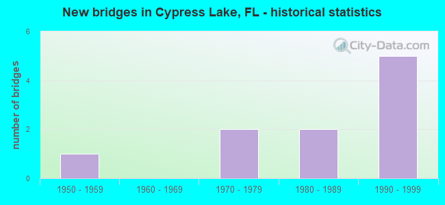
- New bridges - historical statistics
- 11950-1959
- 21970-1979
- 21980-1989
- 51990-1999
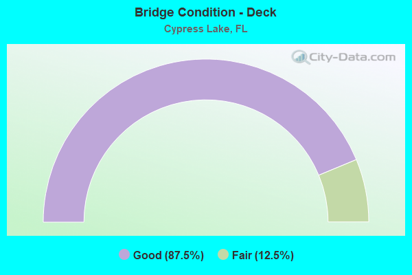
- Bridge Condition - Deck
- 87.5%Good
- 12.5%Fair
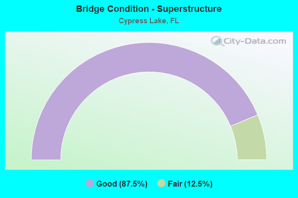
- Bridge Condition - Superstructure
- 87.5%Good
- 12.5%Fair
Find on map >> Show street view
Structure Number: 124025, Location: 0.3Mi S ORANGE RIVR BLVD (Lat: 26.670336, Lng: -81.731911), Route carried "on" structure: County highway , Year Built: 1955, Status: Open, Structure Length: 3.69m (12.11ft), Average Daily Traffic: 8,000 (year 2021), Truck Traffic: 5%, Average Future Daily Traffic: 8,400 (year 2041), Design Load: H 20, Features Intersected: ORANGE RIVER, Facility Carried by Structure: BUCKINGHAM ROAD
Minimum Vertical Clearance: 30+ m (98+ ft), Kilometerpoint: 2.124, Lanes on structure: 2, Owner: County Highway Agency, Approaching Roadway Width: 7.9m (25.9ft), Material/Design: Concrete, Design/Construction: Slab, Number Of Spans In Main Unit: 8, Length of Maximum Span: 4.6m (15.1ft), Curb or Sidewalk Widths: Left: 0.5m (1.6ft), Right: 0.5m (1.6ft), Curb-To-Curb Width: 7.3m (24.0ft), Out-to-Out Width: 8.9m (29.2ft)
Condition: Deck: Good, Superstructure: Good, Substructure: Good, Channel: Good, Operating Rating: 45.1 metric tons, Method Used To Determine Operating Rating: Load Factor (LF), Inventory Rating: 27.0 metric tons, Method Used To Determine Inventory Rating: Load Factor (LF), Structural Evaluation: Equal to present minimum criteria, Deck Geometry: High priority of replacement, Waterway Adequacy: Better than present minimum criteria, Approach Roadway Alignment: Equal to present desirable criteria, Designated Inspection Frequency: Every 24 months, Underwater Inspection Frequency: Every 24 months, Inspection Date: July 2021, Underwater Inspection Date: June 2021, Deck Structure Type: Concrete Precast Panels, Wearing Surface/Protective System: Wearing Surface: Bituminous
Find on map >> Show street view
Structure Number: 124046, Location: 1.0MI EAST OF US-41 (Lat: 26.528050, Lng: -81.854869), Route carried "on" structure: County highway 865, Year Built: 1978, Status: Open, Structure Length: 3.20m (10.50ft), Average Daily Traffic: 16,250 (year 2022), Truck Traffic: 7%, Average Future Daily Traffic: 28,194 (year 2042), Features Intersected: TEN MILE CANAL, Facility Carried by Structure: SIX MI CYP PKWY EB
Minimum Vertical Clearance: 30+ m (98+ ft), Kilometerpoint: 16.982, Lanes on structure: 2, Owner: State Highway Agency, Approaching Roadway Width: 8.6m (28.2ft), Material/Design: Prestressed concrete, Design/Construction: Slab, Number Of Spans In Main Unit: 3, Length of Maximum Span: 10.7m (35.1ft), Curb-To-Curb Width: 12.4m (40.7ft), Out-to-Out Width: 13.3m (43.6ft)
Condition: Deck: Fair, Superstructure: Fair, Substructure: Good, Channel: Good, Operating Rating: 45.5 metric tons, Method Used To Determine Operating Rating: Load Factor (LF), Inventory Rating: 26.2 metric tons, Method Used To Determine Inventory Rating: Load Factor (LF), Structural Evaluation: Somewhat better than minimum adequacy, Deck Geometry: Better than present minimum criteria, Waterway Adequacy: Better than present minimum criteria, Approach Roadway Alignment: Equal to present desirable criteria, Designated Inspection Frequency: Every 24 months, Underwater Inspection Frequency: Every 24 months, Inspection Date: Febuary 2022, Underwater Inspection Date: January 2022, Deck Structure Type: Concrete Precast Panels, Wearing Surface/Protective System: Wearing Surface: Bituminous
Find on map >> Show street view
Structure Number: 12405, Location: 0.1 mi. E of SIX MI CYP P (Lat: 26.546800, Lng: -81.837072), Route carried "on" structure: County highway 876, Year Built: 1981, Year Reconstructed: 1990, Status: Open, Structure Length: 2.74m (8.99ft), Average Daily Traffic: 55,000 (year 2021), Truck Traffic: 5%, Average Future Daily Traffic: 68,750 (year 2041), Design Load: HS 20, Features Intersected: SIX MILE CREEK, Facility Carried by Structure: DANIELS PKWY WB
Minimum Vertical Clearance: 30+ m (98+ ft), Kilometerpoint: 7.712, Lanes on structure: 3, Owner: County Highway Agency, Approaching Roadway Width: 15.9m (52.2ft), Material/Design: Concrete continuous, Design/Construction: Slab, Number Of Spans In Main Unit: 3, Length of Maximum Span: 9.2m (30.2ft), Curb or Sidewalk Widths: Left: 2.7m (8.9ft), Right: 0.0m, Curb-To-Curb Width: 15.9m (52.2ft), Out-to-Out Width: 19.6m (64.3ft)
Condition: Deck: Good, Superstructure: Good, Substructure: Good, Channel: Good, Operating Rating: 71.4 metric tons, Method Used To Determine Operating Rating: Load Factor (LF), Inventory Rating: 42.8 metric tons, Method Used To Determine Inventory Rating: Load Factor (LF), Structural Evaluation: Better than present minimum criteria, Deck Geometry: Better than present minimum criteria, Approach Roadway Alignment: Equal to present desirable criteria, Designated Inspection Frequency: Every 24 months, Underwater Inspection Frequency: Every 24 months, Inspection Date: March 2021, Underwater Inspection Date: Febuary 2021, Deck Structure Type: Concrete Cast-file-Place, Wearing Surface/Protective System: Wearing Surface: Bituminous
Find on map >> Show street view
Structure Number: 124051, Location: 0.3 mi. E of SIX MI CYP P (Lat: 26.546553, Lng: -81.834450), Route carried "on" structure: County highway 876, Year Built: 1981, Year Reconstructed: 1990, Status: Open, Structure Length: 3.66m (12.01ft), Average Daily Traffic: 57,000 (year 2021), Truck Traffic: 5%, Average Future Daily Traffic: 71,250 (year 2041), Design Load: HS 20, Features Intersected: SIX MILE CYPRESS CREEK, Facility Carried by Structure: DANIELS PKWY WB
Minimum Vertical Clearance: 30+ m (98+ ft), Kilometerpoint: 7.965, Lanes on structure: 3, Owner: County Highway Agency, Approaching Roadway Width: 15.2m (49.9ft), Material/Design: Concrete continuous, Design/Construction: Slab, Number Of Spans In Main Unit: 4, Length of Maximum Span: 9.2m (30.2ft), Curb or Sidewalk Widths: Left: 2.7m (8.9ft), Right: 0.0m, Curb-To-Curb Width: 16.0m (52.5ft), Out-to-Out Width: 19.6m (64.3ft)
Condition: Deck: Good, Superstructure: Good, Substructure: Good, Channel: Good, Operating Rating: 67.6 metric tons, Method Used To Determine Operating Rating: Load Factor (LF), Inventory Rating: 40.4 metric tons, Method Used To Determine Inventory Rating: Load Factor (LF), Structural Evaluation: Better than present minimum criteria, Deck Geometry: Better than present minimum criteria, Waterway Adequacy: Better than present minimum criteria, Approach Roadway Alignment: Equal to present desirable criteria, Designated Inspection Frequency: Every 24 months, Underwater Inspection Frequency: Every 24 months, Inspection Date: March 2021, Underwater Inspection Date: Febuary 2021, Deck Structure Type: Concrete Cast-file-Place, Wearing Surface/Protective System: Wearing Surface: Bituminous
Find on map >> Show street view
Structure Number: 124066, Location: 2.4MI WEST OF US-41 (Lat: 26.556853, Lng: -81.910381), Route carried "on" structure: County highway , Year Built: 1990, Status: Open, Structure Length: 56.94m (186.81ft), Average Daily Traffic: 36,300 (year 2021), Truck Traffic: 10%, Average Future Daily Traffic: 38,115 (year 2041), Design Load: HS 20, Features Intersected: MCGREGOR BLVD., Facility Carried by Structure: COLLEGE PARKWAY
Minimum Vertical Clearance: 30+ m (98+ ft), Kilometerpoint: 3.103, Lanes on structure: 4, Lanes under structure: 8, Owner: County Highway Agency, Approaching Roadway Width: 22.3m (73.2ft), Skew: 30 degrees, Material/Design: Steel, Design/Construction: Stringer/Multi-beam, Number Of Spans In Main Unit: 1, Number Of Approach Spans: 18, Length of Maximum Span: 64.1m (210.3ft), Curb-To-Curb Width: 22.3m (73.2ft), Out-to-Out Width: 23.8m (78.1ft)
Condition: Deck: Good, Superstructure: Good, Substructure: Good, Operating Rating: 51.7 metric tons, Method Used To Determine Operating Rating: Load Factor (LF), Inventory Rating: 30.8 metric tons, Method Used To Determine Inventory Rating: Load Factor (LF), Structural Evaluation: Better than present minimum criteria, Deck Geometry: Superior to present desirable criteria, Underclear: Meets minimum limits, Approach Roadway Alignment: Better than present minimum criteria, Designated Inspection Frequency: Every 24 months, Inspection Date: June 2021, Deck Structure Type: Concrete Cast-file-Place, Wearing Surface/Protective System: Wearing Surface: Bituminous
Find on map >> Show street view
Structure Number: 124073, Location: 0.1 mi. E of SIX MI CYP P (Lat: 26.546581, Lng: -81.837058), Route carried "on" structure: County highway 876, Year Built: 1990, Status: Open, Structure Length: 2.74m (8.99ft), Average Daily Traffic: 55,000 (year 2021), Truck Traffic: 5%, Average Future Daily Traffic: 68,750 (year 2041), Design Load: HS 20, Features Intersected: SIX MILE CREEK, Facility Carried by Structure: DANIELS PKWY EB
Minimum Vertical Clearance: 30+ m (98+ ft), Kilometerpoint: 7.712, Lanes on structure: 3, Owner: County Highway Agency, Approaching Roadway Width: 15.8m (51.8ft), Material/Design: Concrete continuous, Design/Construction: Slab, Number Of Spans In Main Unit: 3, Length of Maximum Span: 9.4m (30.8ft), Curb-To-Curb Width: 15.8m (51.8ft), Out-to-Out Width: 16.7m (54.8ft)
Condition: Deck: Good, Superstructure: Good, Substructure: Good, Channel: Good, Operating Rating: 65.2 metric tons, Method Used To Determine Operating Rating: Load Factor (LF), Inventory Rating: 39.2 metric tons, Method Used To Determine Inventory Rating: Load Factor (LF), Structural Evaluation: Better than present minimum criteria, Deck Geometry: Better than present minimum criteria, Waterway Adequacy: Better than present minimum criteria, Approach Roadway Alignment: Equal to present desirable criteria, Designated Inspection Frequency: Every 24 months, Underwater Inspection Frequency: Every 24 months, Inspection Date: March 2021, Underwater Inspection Date: Febuary 2021, Deck Structure Type: Concrete Cast-file-Place
Find on map >> Show street view
Structure Number: 124074, Location: 0.3mi. E of SIX MILE CYP (Lat: 26.546369, Lng: -81.834481), Route carried "on" structure: County highway 876, Year Built: 1991, Status: Open, Structure Length: 3.66m (12.01ft), Average Daily Traffic: 57,000 (year 2021), Truck Traffic: 5%, Average Future Daily Traffic: 71,250 (year 2041), Design Load: HS 20, Features Intersected: SIX MILE CYPRESS CREEK, Facility Carried by Structure: DANIELS PKWY EB
Minimum Vertical Clearance: 30+ m (98+ ft), Kilometerpoint: 7.965, Lanes on structure: 3, Owner: County Highway Agency, Approaching Roadway Width: 15.4m (50.5ft), Material/Design: Concrete continuous, Design/Construction: Slab, Number Of Spans In Main Unit: 4, Length of Maximum Span: 9.2m (30.2ft), Curb-To-Curb Width: 15.8m (51.8ft), Out-to-Out Width: 16.7m (54.8ft)
Condition: Deck: Good, Superstructure: Good, Substructure: Good, Channel: Good, Operating Rating: 69.9 metric tons, Method Used To Determine Operating Rating: Load Factor (LF), Inventory Rating: 38.8 metric tons, Method Used To Determine Inventory Rating: Load Factor (LF), Structural Evaluation: Better than present minimum criteria, Deck Geometry: Better than present minimum criteria, Waterway Adequacy: Better than present minimum criteria, Approach Roadway Alignment: Equal to present desirable criteria, Designated Inspection Frequency: Every 24 months, Underwater Inspection Frequency: Every 24 months, Inspection Date: March 2021, Underwater Inspection Date: Febuary 2021, Deck Structure Type: Concrete Cast-file-Place, Wearing Surface/Protective System: Wearing Surface: Monolithic Concrete
Find on map >> Show street view
Structure Number: 124075, Location: 1.0 MILE EAST OF US-41 (Lat: 26.528258, Lng: -81.854897), Route carried "on" structure: County highway 865, Year Built: 1991, Status: Open, Structure Length: 3.20m (10.50ft), Average Daily Traffic: 16,250 (year 2022), Truck Traffic: 7%, Average Future Daily Traffic: 28,194 (year 2042), Design Load: HS 20, Features Intersected: TEN MILE CANAL, Facility Carried by Structure: SIX MI CYP PKWY WB
Minimum Vertical Clearance: 30+ m (98+ ft), Kilometerpoint: 16.982, Lanes on structure: 3, Owner: State Highway Agency, Approaching Roadway Width: 13.2m (43.3ft), Material/Design: Concrete continuous, Design/Construction: Slab, Number Of Spans In Main Unit: 3, Length of Maximum Span: 10.5m (34.4ft), Curb-To-Curb Width: 15.8m (51.8ft), Out-to-Out Width: 16.7m (54.8ft)
Condition: Deck: Good, Superstructure: Good, Substructure: Good, Channel: Good, Operating Rating: 57.1 metric tons, Method Used To Determine Operating Rating: Load Factor (LF), Inventory Rating: 34.2 metric tons, Method Used To Determine Inventory Rating: Load Factor (LF), Structural Evaluation: Better than present minimum criteria, Deck Geometry: Better than present minimum criteria, Waterway Adequacy: Superior to present desirable criteria, Approach Roadway Alignment: Equal to present desirable criteria, Designated Inspection Frequency: Every 24 months, Underwater Inspection Frequency: Every 24 months, Inspection Date: Febuary 2022, Underwater Inspection Date: January 2022, Deck Structure Type: Concrete Cast-file-Place, Wearing Surface/Protective System: Wearing Surface: Bituminous
Find on map >> Show street view
Structure Number: 124124, Location: 1.3MI S OF CYPRESS LAKE D (Lat: 26.527722, Lng: -81.887039), Route carried "on" structure: County highway 869, Year Built: 1978, Status: Open, Structure Length: 0.71m (2.33ft), Average Daily Traffic: 42,200 (year 2021), Truck Traffic: 5%, Average Future Daily Traffic: 44,310 (year 2041), Design Load: HS 20, Features Intersected: HENDRY CREEK, Facility Carried by Structure: SUMMERLIN RD
Minimum Vertical Clearance: 30+ m (98+ ft), Kilometerpoint: 10.609, Lanes on structure: 5, Owner: County Highway Agency, Approaching Roadway Width: 19.2m (63.0ft), Skew: 26 degrees, Material/Design: Concrete, Design/Construction: Culvert, Number Of Spans In Main Unit: 1, Length of Maximum Span: 7.1m (23.3ft)
Condition: Channel: Good, Culverts: Good, Operating Rating: 32.7 metric tons, Method Used To Determine Operating Rating: Load Factor (LF), Inventory Rating: 19.6 metric tons, Method Used To Determine Inventory Rating: Load Factor (LF), Structural Evaluation: Meets minimum limits, Waterway Adequacy: Better than present minimum criteria, Approach Roadway Alignment: Equal to present desirable criteria, Designated Inspection Frequency: Every 24 months, Inspection Date: July 2021, Deck Structure Type: Concrete Cast-file-Place
Find on map >> Show street view
Structure Number: 124066, Location: 2.4MI WEST OF US-41 (Lat: 26.556853, Lng: -81.910381), Route carried "under" structure: State highway , Year Built: 1990, Structure Length: 0. m, Average Daily Traffic: 36,300 (year 2021), Truck Traffic: 4%, Features Intersected: MCGREGOR BLVD., Facility Carried by Structure: COLLEGE PARKWAY
Minimum Vertical Clearance: 4.91m (16.11ft), Kilometerpoint: 0.000, Lanes on structure: 4, Lanes under structure: 8, Material/Design: Steel, Design/Construction: Stringer/Multi-beam, Length of Maximum Span: 64.1m (210.3ft)