Bridge Statistics for Danville, Vermont (VT)
Condition, Traffic, Stress, Structural Evaluation, Project Costs
- National Bridge Inventory (NBI) Statistics
- 17Number of bridges
- 75ft / 22.6mTotal length
- $2,189,000Total costs
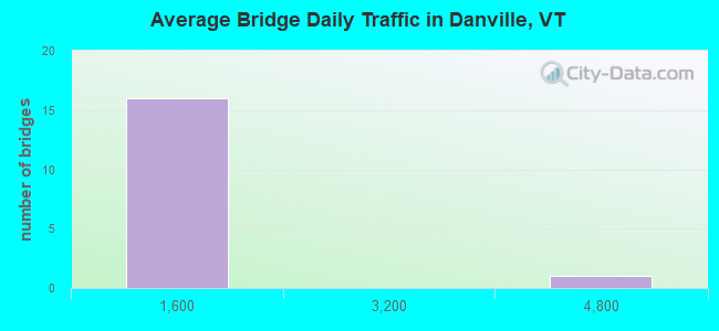
- 7,800Total average daily traffic
- 601Total average daily truck traffic
- National Bridge Inventory (NBI) Registered Bridges for Danville
- No street view available for this location
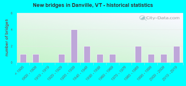
- New bridges - historical statistics
- 1Before 1900
- 11900-1909
- 11920-1929
- 41930-1939
- 21940-1949
- 11950-1959
- 11960-1969
- 21980-1989
- 11990-1999
- 12000-2009
- 22010-2019
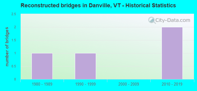
- Reconstructed bridges - Historical Statistics
- 11980-1989
- 11990-1999
- 02000-2009
- 22010-2019
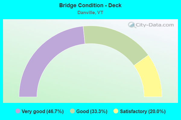
- Bridge Condition - Deck
- 46.7%Very good
- 33.3%Good
- 20.0%Satisfactory
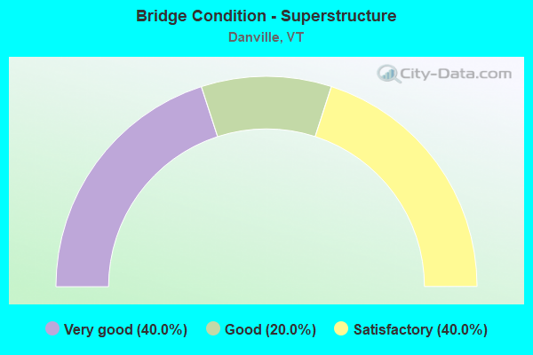
- Bridge Condition - Superstructure
- 40.0%Very good
- 20.0%Good
- 40.0%Satisfactory
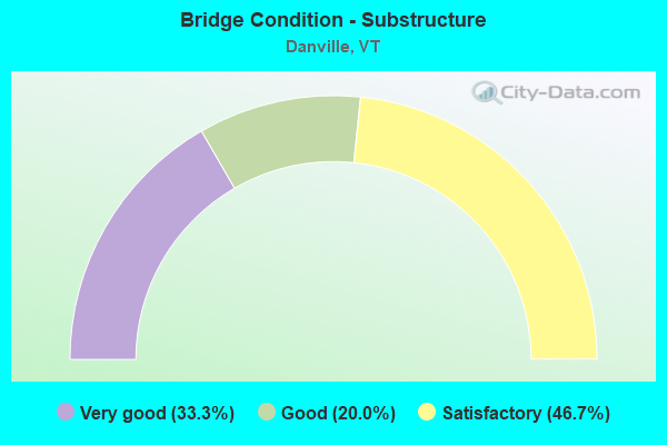
- Bridge Condition - Substructure
- 33.3%Very good
- 20.0%Good
- 46.7%Satisfactory
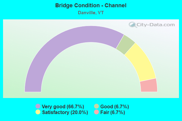
- Bridge Condition - Channel
- 66.7%Very good
- 6.7%Good
- 20.0%Satisfactory
- 6.7%Fair
Find on map >> Show street view
Structure Number: 100303000403031, Location: 0.1 MI JCT TH 74 + TH 1 (Lat: 44.378681, Lng: -72.092211), Route carried "on" structure: Other road C2001, Year Built: 1949, Year Reconstructed: 2018, Status: Open, Structure Length: 1.49m (4.89ft), Average Daily Traffic: 300 (year 2019), Truck Traffic: 3%, Average Future Daily Traffic: 315 (year 2029), Design Load: H 15, Features Intersected: JOES BROOK
Minimum Vertical Clearance: 30+ m (98+ ft), Kilometerpoint: 0.000, Lanes on structure: 2, Owner: Town or Township Highway Agency, Approaching Roadway Width: 6.7m (22.0ft), Skew: 1 degrees, Material/Design: Prestressed concrete, Design/Construction: Slab, Number Of Spans In Main Unit: 1, Length of Maximum Span: 14.3m (46.9ft), Curb-To-Curb Width: 8.1m (26.6ft), Out-to-Out Width: 8.5m (27.9ft)
Condition: Deck: Very good, Superstructure: Very good, Substructure: Satisfactory, Channel: Satisfactory, Operating Rating: 53.5 metric tons, Method Used To Determine Operating Rating: Allowable Stress (AS), Inventory Rating: 29.9 metric tons, Method Used To Determine Inventory Rating: Allowable Stress (AS), Structural Evaluation: Equal to present minimum criteria, Deck Geometry: Somewhat better than minimum adequacy, Waterway Adequacy: Better than present minimum criteria, Approach Roadway Alignment: Equal to present desirable criteria, Designated Inspection Frequency: Every 24 months, Inspection Date: September 2021, Deck Structure Type: Concrete Precast Panels, Wearing Surface/Protective System: Deck Protection: Epoxy Coated Reinforcing
Find on map >> Show street view
Structure Number: 100303002503031, Location: 0.1 MI JCT TH 61 + TH 73 (Lat: 44.389636, Lng: -72.062381), Route carried "on" structure: Other road C3061, Year Built: 1947, Status: Open, Structure Length: 0.73m (2.40ft), Average Daily Traffic: 50 (year 2019), Truck Traffic: 2%, Average Future Daily Traffic: 53 (year 2029), Features Intersected: WATER ANDRIC
Minimum Vertical Clearance: 30+ m (98+ ft), Kilometerpoint: 0.000, Lanes on structure: 2, Owner: Town or Township Highway Agency, Approaching Roadway Width: 5.2m (17.1ft), Material/Design: Concrete, Design/Construction: Slab, Number Of Spans In Main Unit: 1, Length of Maximum Span: 6.7m (22.0ft), Curb-To-Curb Width: 6.2m (20.3ft), Out-to-Out Width: 6.7m (22.0ft)
Condition: Deck: Good, Superstructure: Good, Substructure: Satisfactory, Channel: Fair, Operating Rating: 18.1 metric tons, Method Used To Determine Operating Rating: Field evaluation and documented engineering judgment, Inventory Rating: 10.9 metric tons, Method Used To Determine Inventory Rating: Field evaluation and documented engineering judgment, Structural Evaluation: Meets minimum limits, Deck Geometry: Somewhat better than minimum adequacy, Waterway Adequacy: Somewhat better than minimum adequacy, Approach Roadway Alignment: Equal to present minimum criteria, Length Of Structure Improvement: 0.73m (2.40ft), Designated Inspection Frequency: Every 24 months, Inspection Date: September 2021, Bridge Improvement Cost: $186,000, Roadway Improvement Cost: $50,000, Total Project Cost: $236,000 ( Estimate for 2020), Deck Structure Type: Concrete Cast-file-Place
Find on map >> Show street view
Structure Number: 100303002703031, Location: 0.5 MI JCT TH30 + TH 42 (Lat: 44.498964, Lng: -72.104808), Route carried "on" structure: Other road C3030, Year Built: 2005, Status: Open, Structure Length: 0.76m (2.49ft), Average Daily Traffic: 100 (year 2019), Truck Traffic: 5%, Average Future Daily Traffic: 105 (year 2029), Design Load: HS 25 or greater, Features Intersected: HOUGHTON BROOK
Minimum Vertical Clearance: 30+ m (98+ ft), Kilometerpoint: 0.000, Lanes on structure: 2, Owner: Town or Township Highway Agency, Approaching Roadway Width: 7.3m (24.0ft), Skew: 2 degrees, Material/Design: Concrete, Design/Construction: Culvert, Number Of Spans In Main Unit: 1, Length of Maximum Span: 7.6m (24.9ft)
Condition: Channel: Very good, Culverts: Very good, Operating Rating: 68.0 metric tons, Method Used To Determine Operating Rating: Field evaluation and documented engineering judgment, Inventory Rating: 40.8 metric tons, Method Used To Determine Inventory Rating: Field evaluation and documented engineering judgment, Structural Evaluation: Equal to present desirable criteria, Waterway Adequacy: Equal to present desirable criteria, Approach Roadway Alignment: Equal to present desirable criteria, Designated Inspection Frequency: Every 24 months, Inspection Date: September 2021
Find on map >> Show street view
Structure Number: 100303002903031, Location: 0.1 MI JCT TH 60 + TH 61 (Lat: 44.412600, Lng: -72.116928), Route carried "on" structure: Other road C3060, Year Built: 1920, Status: Posted for load, Structure Length: 1.10m (3.61ft), Average Daily Traffic: 100 (year 2019), Truck Traffic: 2%, Average Future Daily Traffic: 105 (year 2029), Features Intersected: LAMOILLE VALLEY RR
Minimum Vertical Clearance: 30+ m (98+ ft), Kilometerpoint: 0.000, Lanes on structure: 1, Owner: State Highway Agency, Approaching Roadway Width: 5.2m (17.1ft), Material/Design: Wood or Timber, Design/Construction: Stringer/Multi-beam, Number Of Spans In Main Unit: 1, Length of Maximum Span: 9.8m (32.2ft), Curb-To-Curb Width: 4.4m (14.4ft), Out-to-Out Width: 4.9m (16.1ft)
Condition: Deck: Satisfactory, Superstructure: Satisfactory, Substructure: Good, Operating Rating: 13.6 metric tons, Method Used To Determine Operating Rating: Allowable Stress (AS), Inventory Rating: 9.1 metric tons, Method Used To Determine Inventory Rating: Allowable Stress (AS), Structural Evaluation: High priority of replacement, Deck Geometry: Equal to present minimum criteria, Approach Roadway Alignment: Somewhat better than minimum adequacy, Bridge Posting: Required (Relationship of Operating Rating to Maximum Legal Load: 0.1 - 9.9% below), Length Of Structure Improvement: 1.77m (5.81ft), Designated Inspection Frequency: Every 24 months, Inspection Date: September 2021, Bridge Improvement Cost: $313,000, Roadway Improvement Cost: $150,000, Total Project Cost: $463,000 ( Estimate for 2020), Deck Structure Type: Wood or Timber, Wearing Surface/Protective System: Wearing Surface: Wood or Timber, Deck Protection: Internally Sealed
Find on map >> Show street view
Structure Number: 100303003003031, Location: 0.2 MI JCT TH 65 + TH 2 (Lat: 44.445386, Lng: -72.061844), Route carried "on" structure: Other road C3065, Year Built: 1952, Status: Open, Structure Length: 0.73m (2.40ft), Average Daily Traffic: 100 (year 2019), Truck Traffic: 2%, Average Future Daily Traffic: 105 (year 2029), Features Intersected: ROY BROOK
Minimum Vertical Clearance: 30+ m (98+ ft), Kilometerpoint: 0.000, Lanes on structure: 1, Owner: Town or Township Highway Agency, Approaching Roadway Width: 5.8m (19.0ft), Skew: 1 degrees, Material/Design: Steel, Design/Construction: Stringer/Multi-beam, Number Of Spans In Main Unit: 1, Length of Maximum Span: 6.4m (21.0ft), Curb or Sidewalk Widths: Left: 0.1m (0.3ft), Right: 0.1m (0.3ft), Curb-To-Curb Width: 4.5m (14.8ft), Out-to-Out Width: 4.7m (15.4ft)
Condition: Deck: Good, Superstructure: Satisfactory, Substructure: Satisfactory, Channel: Very good, Operating Rating: 30.8 metric tons, Method Used To Determine Operating Rating: Load Factor (LF), Inventory Rating: 19.1 metric tons, Method Used To Determine Inventory Rating: Load Factor (LF), Structural Evaluation: Somewhat better than minimum adequacy, Deck Geometry: Equal to present minimum criteria, Waterway Adequacy: Equal to present minimum criteria, Approach Roadway Alignment: Equal to present minimum criteria, Length Of Structure Improvement: 0.73m (2.40ft), Designated Inspection Frequency: Every 24 months, Inspection Date: September 2021, Bridge Improvement Cost: $129,000, Roadway Improvement Cost: $50,000, Total Project Cost: $179,000 ( Estimate for 2020), Deck Structure Type: Concrete Cast-file-Place
Find on map >> Show street view
Structure Number: 100303003103031, Location: 2.2 MI SE US2 + TH60 (Lat: 44.403433, Lng: -72.091761), Route carried "on" structure: Other road C4078, Year Built: 2017, Status: Posted for load, Structure Length: 1.52m (4.99ft), Average Daily Traffic: 25 (year 2017), Truck Traffic: 1%, Average Future Daily Traffic: 27 (year 2027), Design Load: H 20, Features Intersected: WATER ANDRIC
Minimum Vertical Clearance: 30+ m (98+ ft), Kilometerpoint: 0.000, Lanes on structure: 1, Owner: Town or Township Highway Agency, Approaching Roadway Width: 4.9m (16.1ft), Skew: 2 degrees, Material/Design: Steel, Design/Construction: Stringer/Multi-beam, Number Of Spans In Main Unit: 1, Length of Maximum Span: 14.9m (48.9ft), Curb or Sidewalk Widths: Left: 0.2m (0.7ft), Right: 0.2m (0.7ft), Curb-To-Curb Width: 3.8m (12.5ft), Out-to-Out Width: 4.9m (16.1ft)
Condition: Deck: Very good, Superstructure: Good, Substructure: Very good, Channel: Good, Operating Rating: 28.1 metric tons, Method Used To Determine Operating Rating: Allowable Stress (AS), Inventory Rating: 20.9 metric tons, Method Used To Determine Inventory Rating: Allowable Stress (AS), Structural Evaluation: Equal to present minimum criteria, Deck Geometry: Meets minimum limits, Waterway Adequacy: Somewhat better than minimum adequacy, Approach Roadway Alignment: Equal to present desirable criteria, Length Of Structure Improvement: 1.52m (4.99ft), Designated Inspection Frequency: Every 24 months, Inspection Date: September 2021, Bridge Improvement Cost: $280,000, Roadway Improvement Cost: $50,000, Total Project Cost: $330,000 ( Estimate for 2020), Deck Structure Type: Wood or Timber, Wearing Surface/Protective System: Wearing Surface: Wood or Timber, Deck Protection: Internally Sealed
Find on map >> Show street view
Structure Number: 100303003503031, Location: 0.5 MI JCT TH 91 + TH 3 (Lat: 44.385372, Lng: -72.152319), Route carried "on" structure: Other road C3091, Year Built: 1989, Status: Open, Structure Length: 1.37m (4.49ft), Average Daily Traffic: 20 (year 2019), Truck Traffic: 2%, Average Future Daily Traffic: 21 (year 2029), Design Load: HS 20, Features Intersected: JOES BROOK
Minimum Vertical Clearance: 30+ m (98+ ft), Kilometerpoint: 0.000, Lanes on structure: 2, Owner: Town or Township Highway Agency, Approaching Roadway Width: 7.3m (24.0ft), Skew: 3 degrees, Material/Design: Concrete, Design/Construction: Slab, Number Of Spans In Main Unit: 1, Length of Maximum Span: 13.1m (43.0ft), Curb-To-Curb Width: 7.2m (23.6ft), Out-to-Out Width: 7.7m (25.3ft)
Condition: Deck: Very good, Superstructure: Very good, Substructure: Very good, Channel: Very good, Operating Rating: 69.9 metric tons, Method Used To Determine Operating Rating: Allowable Stress (AS), Inventory Rating: 35.4 metric tons, Method Used To Determine Inventory Rating: Allowable Stress (AS), Structural Evaluation: Equal to present desirable criteria, Deck Geometry: Somewhat better than minimum adequacy, Waterway Adequacy: Equal to present desirable criteria, Approach Roadway Alignment: Somewhat better than minimum adequacy, Designated Inspection Frequency: Every 24 months, Inspection Date: September 2021, Deck Structure Type: Concrete Cast-file-Place
Find on map >> Show street view
Structure Number: 100303003603031, Location: 1.6 MI JCT TH 12 + TH 3 (Lat: 44.393706, Lng: -72.166228), Route carried "on" structure: Other road C3012, Year Built: 1985, Status: Open, Structure Length: 1.04m (3.41ft), Average Daily Traffic: 30 (year 2019), Truck Traffic: 2%, Average Future Daily Traffic: 32 (year 2029), Design Load: HS 20, Features Intersected: JOES BROOK
Minimum Vertical Clearance: 30+ m (98+ ft), Kilometerpoint: 0.000, Lanes on structure: 2, Owner: Town or Township Highway Agency, Approaching Roadway Width: 7.3m (24.0ft), Material/Design: Concrete, Design/Construction: Slab, Number Of Spans In Main Unit: 1, Length of Maximum Span: 9.4m (30.8ft), Curb-To-Curb Width: 7.3m (24.0ft), Out-to-Out Width: 7.8m (25.6ft)
Condition: Deck: Very good, Superstructure: Very good, Substructure: Very good, Channel: Very good, Operating Rating: 77.1 metric tons, Method Used To Determine Operating Rating: Allowable Stress (AS), Inventory Rating: 45.4 metric tons, Method Used To Determine Inventory Rating: Allowable Stress (AS), Structural Evaluation: Equal to present desirable criteria, Deck Geometry: Equal to present minimum criteria, Waterway Adequacy: Equal to present desirable criteria, Approach Roadway Alignment: Equal to present desirable criteria, Designated Inspection Frequency: Every 24 months, Inspection Date: September 2021, Deck Structure Type: Concrete Cast-file-Place
Find on map >> Show street view
Structure Number: 100303003703031, Location: 0.5 MI JCT TH 56 + TH 3 (Lat: 44.379597, Lng: -72.134172), Route carried "on" structure: Other road C3056, Year Built: 1965, Status: Open, Structure Length: 1.07m (3.51ft), Average Daily Traffic: 100 (year 2019), Truck Traffic: 2%, Average Future Daily Traffic: 105 (year 2029), Features Intersected: JOES BROOK
Minimum Vertical Clearance: 30+ m (98+ ft), Kilometerpoint: 0.000, Lanes on structure: 2, Owner: Town or Township Highway Agency, Approaching Roadway Width: 6.1m (20.0ft), Skew: 1 degrees, Material/Design: Steel, Design/Construction: Stringer/Multi-beam, Number Of Spans In Main Unit: 1, Length of Maximum Span: 10.1m (33.1ft), Curb-To-Curb Width: 6.8m (22.3ft), Out-to-Out Width: 7.3m (24.0ft)
Condition: Deck: Good, Superstructure: Satisfactory, Substructure: Good, Channel: Very good, Operating Rating: 27.2 metric tons, Method Used To Determine Operating Rating: Allowable Stress (AS), Inventory Rating: 17.2 metric tons, Method Used To Determine Inventory Rating: Allowable Stress (AS), Structural Evaluation: Somewhat better than minimum adequacy, Deck Geometry: Somewhat better than minimum adequacy, Waterway Adequacy: Equal to present minimum criteria, Approach Roadway Alignment: Equal to present minimum criteria, Length Of Structure Improvement: 1.07m (3.51ft), Designated Inspection Frequency: Every 24 months, Inspection Date: September 2021, Bridge Improvement Cost: $295,000, Roadway Improvement Cost: $50,000, Total Project Cost: $345,000 ( Estimate for 2020), Deck Structure Type: Concrete Cast-file-Place
Find on map >> Show street view
Structure Number: 100303003803031, Location: 0.05 MI JCT TH 40 + TH 2 (Lat: 44.458117, Lng: -72.095158), Route carried "on" structure: Other road C3040, Year Built: 1996, Status: Open, Structure Length: 1.40m (4.59ft), Average Daily Traffic: 75 (year 2019), Truck Traffic: 2%, Average Future Daily Traffic: 79 (year 2029), Design Load: HS 25 or greater, Features Intersected: SLEEPERS RIVER
Minimum Vertical Clearance: 30+ m (98+ ft), Kilometerpoint: 0.000, Lanes on structure: 2, Owner: Town or Township Highway Agency, Approaching Roadway Width: 6.1m (20.0ft), Material/Design: Concrete, Design/Construction: Slab, Number Of Spans In Main Unit: 1, Length of Maximum Span: 13.4m (44.0ft), Curb or Sidewalk Widths: Left: 0.1m (0.3ft), Right: 0.1m (0.3ft), Curb-To-Curb Width: 7.3m (24.0ft), Out-to-Out Width: 7.9m (25.9ft)
Condition: Deck: Very good, Superstructure: Very good, Substructure: Very good, Channel: Very good, Operating Rating: 71.7 metric tons, Method Used To Determine Operating Rating: Load Factor (LF), Inventory Rating: 42.6 metric tons, Method Used To Determine Inventory Rating: Load Factor (LF), Structural Evaluation: Equal to present desirable criteria, Deck Geometry: Equal to present minimum criteria, Waterway Adequacy: Equal to present desirable criteria, Approach Roadway Alignment: Equal to present desirable criteria, Designated Inspection Frequency: Every 24 months, Inspection Date: September 2021, Deck Structure Type: Concrete Cast-file-Place, Wearing Surface/Protective System: Wearing Surface: Bituminous, Membrane: Preformed Fabric, Deck Protection: Epoxy Coated Reinforcing
Find on map >> Show street view
Structure Number: 100303003903031, Location: 0.2 MI JCT TH 61 + TH 79 (Lat: 44.393314, Lng: -72.069197), Route carried "on" structure: Other road C3061, Year Built: 2011, Status: Open, Structure Length: 1.34m (4.40ft), Average Daily Traffic: 50 (year 2019), Truck Traffic: 2%, Average Future Daily Traffic: 53 (year 2029), Features Intersected: WATER ANDRIC
Minimum Vertical Clearance: 30+ m (98+ ft), Kilometerpoint: 0.000, Lanes on structure: 2, Owner: Town or Township Highway Agency, Approaching Roadway Width: 7.3m (24.0ft), Skew: 5 degrees, Material/Design: Concrete, Design/Construction: Slab, Number Of Spans In Main Unit: 1, Length of Maximum Span: 12.8m (42.0ft), Curb-To-Curb Width: 6.8m (22.3ft), Out-to-Out Width: 7.3m (24.0ft)
Condition: Deck: Very good, Superstructure: Very good, Substructure: Very good, Channel: Satisfactory, Operating Rating: 68.0 metric tons, Method Used To Determine Operating Rating: Field evaluation and documented engineering judgment, Inventory Rating: 40.8 metric tons, Method Used To Determine Inventory Rating: Field evaluation and documented engineering judgment, Structural Evaluation: Equal to present desirable criteria, Deck Geometry: Somewhat better than minimum adequacy, Waterway Adequacy: Somewhat better than minimum adequacy, Approach Roadway Alignment: Equal to present desirable criteria, Designated Inspection Frequency: Every 24 months, Inspection Date: September 2021, Deck Structure Type: Concrete Cast-file-Place, Wearing Surface/Protective System: Wearing Surface: Bituminous, Membrane: Preformed Fabric
Find on map >> Show street view
Structure Number: 100303004003031, Location: 0.1 MI JCT TH 56 + TH 54 (Lat: 44.377489, Lng: -72.122008), Route carried "on" structure: Other road C3054, Year Built: 1886, Year Reconstructed: 2002, Status: Posted for load, Structure Length: 2.38m (7.81ft), Average Daily Traffic: 100 (year 2019), Truck Traffic: 2%, Average Future Daily Traffic: 105 (year 2029), Features Intersected: JOES BROOK
Minimum Vertical Clearance: 3.58m (11.75ft), Kilometerpoint: 0.000, Lanes on structure: 1, Owner: Town or Township Highway Agency, Approaching Roadway Width: 5.2m (17.1ft), Material/Design: Wood or Timber, Design/Construction: Truss - Thru, Number Of Spans In Main Unit: 1, Length of Maximum Span: 21.6m (70.9ft), Curb or Sidewalk Widths: Left: 0.3m (1.0ft), Right: 0.3m (1.0ft), Curb-To-Curb Width: 3.0m (9.8ft), Out-to-Out Width: 4.4m (14.4ft)
Condition: Deck: Good, Superstructure: Satisfactory, Substructure: Satisfactory, Channel: Very good, Operating Rating: 10.0 metric tons, Method Used To Determine Operating Rating: Allowable Stress (AS), Inventory Rating: 6.4 metric tons, Method Used To Determine Inventory Rating: Allowable Stress (AS), Structural Evaluation: High priority of replacement, Deck Geometry: High priority of replacement, Waterway Adequacy: Better than present minimum criteria, Approach Roadway Alignment: Meets minimum limits, Bridge Posting: Required (Relationship of Operating Rating to Maximum Legal Load: 0.1 - 9.9% below), Length Of Structure Improvement: 3.08m (10.10ft), Designated Inspection Frequency: Every 24 months, Inspection Date: September 2021, Bridge Improvement Cost: $486,000, Roadway Improvement Cost: $150,000, Total Project Cost: $636,000 ( Estimate for 2020), Deck Structure Type: Wood or Timber
Find on map >> Show street view
Structure Number: 200028009203032, Location: 0.1 MI W JCT VT.15 (Lat: 44.408714, Lng: -72.196167), Route carried "on" structure: US 2, Year Built: 1934, Year Reconstructed: 1987, Status: Open, Structure Length: 2.26m (7.41ft), Average Daily Traffic: 4,300 (year 2018), Truck Traffic: 10%, Average Future Daily Traffic: 4,515 (year 2028), Design Load: HS 20+Mod, Features Intersected: JOES BROOK
Minimum Vertical Clearance: 30+ m (98+ ft), Kilometerpoint: 165.732, Lanes on structure: 2, Base Highway Network: Yes, Owner: State Highway Agency, Approaching Roadway Width: 12.2m (40.0ft), Skew: 3 degrees, Material/Design: Steel, Design/Construction: Stringer/Multi-beam, Number Of Spans In Main Unit: 1, Length of Maximum Span: 21.6m (70.9ft), Curb or Sidewalk Widths: Left: 1.5m (4.9ft), Right: 0.1m (0.3ft), Curb-To-Curb Width: 10.7m (35.1ft), Out-to-Out Width: 13.1m (43.0ft)
Condition: Deck: Good, Superstructure: Good, Substructure: Satisfactory, Channel: Very good, Operating Rating: 89.8 metric tons, Method Used To Determine Operating Rating: Load Factor (LF), Inventory Rating: 62.6 metric tons, Method Used To Determine Inventory Rating: Load Factor (LF), Structural Evaluation: Equal to present minimum criteria, Deck Geometry: Somewhat better than minimum adequacy, Waterway Adequacy: Equal to present desirable criteria, Approach Roadway Alignment: Equal to present desirable criteria, Designated Inspection Frequency: Every 24 months, Inspection Date: July 2021, Deck Structure Type: Concrete Cast-file-Place, Wearing Surface/Protective System: Wearing Surface: Bituminous, Membrane: Preformed Fabric, Deck Protection: Epoxy Coated Reinforcing
Find on map >> Show street view
Structure Number: 200215000603032, Location: 1.5 MI N JCT US2 EAST (Lat: 44.449189, Lng: -72.063967), Route carried "on" structure: County highway 2, Year Built: 1937, Status: Open, Structure Length: 1.80m (5.91ft), Average Daily Traffic: 520 (year 2017), Truck Traffic: 6%, Average Future Daily Traffic: 546 (year 2027), Design Load: H 15, Features Intersected: SLEEPERS RIVER
Minimum Vertical Clearance: 30+ m (98+ ft), Kilometerpoint: 0.000, Lanes on structure: 2, Owner: Town or Township Highway Agency, Approaching Roadway Width: 6.4m (21.0ft), Skew: 1 degrees, Material/Design: Steel, Design/Construction: Stringer/Multi-beam, Number Of Spans In Main Unit: 1, Length of Maximum Span: 17.4m (57.1ft), Curb or Sidewalk Widths: Left: 0.2m (0.7ft), Right: 0.2m (0.7ft), Curb-To-Curb Width: 6.3m (20.7ft), Out-to-Out Width: 7.1m (23.3ft)
Condition: Deck: Satisfactory, Superstructure: Satisfactory, Substructure: Satisfactory, Channel: Very good, Operating Rating: 89.8 metric tons, Method Used To Determine Operating Rating: Allowable Stress (AS), Inventory Rating: 43.5 metric tons, Method Used To Determine Inventory Rating: Allowable Stress (AS), Structural Evaluation: Equal to present minimum criteria, Deck Geometry: High priority of corrective action, Waterway Adequacy: Equal to present minimum criteria, Approach Roadway Alignment: Equal to present desirable criteria, Designated Inspection Frequency: Every 24 months, Inspection Date: July 2020, Deck Structure Type: Concrete Cast-file-Place, Wearing Surface/Protective System: Wearing Surface: Bituminous, Membrane: Preformed Fabric
Find on map >> Show street view
Structure Number: 200215000703032, Location: 3.3 MI N JCT. U.S.2 EAST (Lat: 44.459047, Lng: -72.095983), Route carried "on" structure: County highway 2, Year Built: 1937, Year Reconstructed: 2010, Status: Open, Structure Length: 1.80m (5.91ft), Average Daily Traffic: 520 (year 2017), Truck Traffic: 6%, Average Future Daily Traffic: 546 (year 2027), Design Load: HS 25 or greater, Features Intersected: NORTH BROOK
Minimum Vertical Clearance: 30+ m (98+ ft), Kilometerpoint: 0.000, Lanes on structure: 2, Owner: Town or Township Highway Agency, Approaching Roadway Width: 6.7m (22.0ft), Skew: 1 degrees, Material/Design: Prestressed concrete, Design/Construction: Slab, Number Of Spans In Main Unit: 1, Length of Maximum Span: 17.4m (57.1ft), Curb-To-Curb Width: 6.4m (21.0ft), Out-to-Out Width: 7.3m (24.0ft)
Condition: Deck: Very good, Superstructure: Very good, Substructure: Good, Channel: Very good, Operating Rating: 89.8 metric tons, Method Used To Determine Operating Rating: Load Factor (LF), Inventory Rating: 55.3 metric tons, Method Used To Determine Inventory Rating: Load Factor (LF), Structural Evaluation: Better than present minimum criteria, Deck Geometry: High priority of corrective action, Waterway Adequacy: Equal to present desirable criteria, Approach Roadway Alignment: Equal to present minimum criteria, Designated Inspection Frequency: Every 24 months, Inspection Date: July 2020, Deck Structure Type: Concrete Precast Panels, Wearing Surface/Protective System: Wearing Surface: Bituminous, Membrane: Preformed Fabric
Find on map >> Show street view
Structure Number: 200215000803032, Location: 3.6 MI N JCT. U.S.2 W (Lat: 44.456181, Lng: -72.124564), Route carried "on" structure: County highway 2, Year Built: 1935, Status: Open, Structure Length: 1.80m (5.91ft), Average Daily Traffic: 740 (year 2017), Truck Traffic: 6%, Average Future Daily Traffic: 777 (year 2027), Design Load: H 15, Features Intersected: MORRILL BROOK
Minimum Vertical Clearance: 30+ m (98+ ft), Kilometerpoint: 0.000, Lanes on structure: 2, Owner: Town or Township Highway Agency, Approaching Roadway Width: 6.4m (21.0ft), Material/Design: Steel, Design/Construction: Stringer/Multi-beam, Number Of Spans In Main Unit: 1, Length of Maximum Span: 17.4m (57.1ft), Curb or Sidewalk Widths: Left: 0.3m (1.0ft), Right: 0.2m (0.7ft), Curb-To-Curb Width: 6.0m (19.7ft), Out-to-Out Width: 7.1m (23.3ft)
Condition: Deck: Satisfactory, Superstructure: Satisfactory, Substructure: Satisfactory, Channel: Satisfactory, Operating Rating: 89.8 metric tons, Method Used To Determine Operating Rating: Allowable Stress (AS), Inventory Rating: 45.4 metric tons, Method Used To Determine Inventory Rating: Allowable Stress (AS), Structural Evaluation: Equal to present minimum criteria, Deck Geometry: High priority of replacement, Waterway Adequacy: Equal to present minimum criteria, Approach Roadway Alignment: Equal to present desirable criteria, Designated Inspection Frequency: Every 24 months, Inspection Date: July 2020, Deck Structure Type: Concrete Cast-file-Place, Wearing Surface/Protective System: Wearing Surface: Bituminous, Membrane: Preformed Fabric
Find on map >> Show street view
Structure Number: 200228000203032, Location: 2.6 MI W JCT US2 E (Lat: 44.432419, Lng: -72.075900), Route carried "under" structure: State highway 2B, Year Built: 1900, Structure Length: 0. m, Average Daily Traffic: 670 (year 1998), Truck Traffic: 6%, Features Intersected: VAST TRAIL OVER VT 2B, Facility Carried by Structure: PED/BIKE PATH
Kilometerpoint: 0.000, Material/Design: Steel, Design/Construction: Truss - Thru, Length of Maximum Span: 22.9m (75.1ft)