Bridge Statistics for Delray Beach, Florida (FL)
Condition, Traffic, Stress, Structural Evaluation, Project Costs
- National Bridge Inventory (NBI) Statistics
- 63Number of bridges
- 761ft / 232mTotal length
- $180,000Total costs
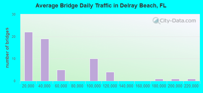
- 2,884,467Total average daily traffic
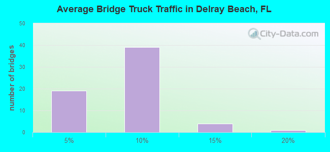
- 203,028Total average daily truck traffic
- National Bridge Inventory (NBI) Registered Bridges for Delray Beach
- No street view available for this location
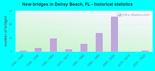
- New bridges - historical statistics
- 11940-1949
- 31950-1959
- 101960-1969
- 21970-1979
- 61980-1989
- 141990-1999
- 262000-2009
- 12020-2022
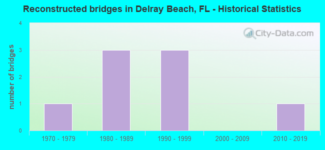
- Reconstructed bridges - Historical Statistics
- 11970-1979
- 31980-1989
- 31990-1999
- 02000-2009
- 12010-2019
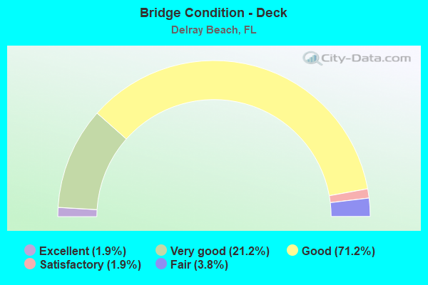
- Bridge Condition - Deck
- 1.9%Excellent
- 21.2%Very good
- 71.2%Good
- 1.9%Satisfactory
- 3.8%Fair
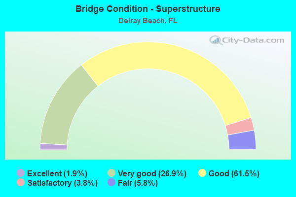
- Bridge Condition - Superstructure
- 1.9%Excellent
- 26.9%Very good
- 61.5%Good
- 3.8%Satisfactory
- 5.8%Fair
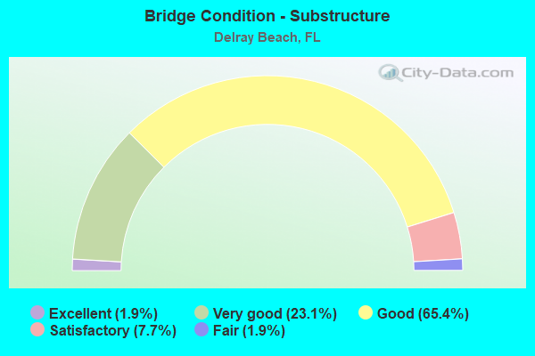
- Bridge Condition - Substructure
- 1.9%Excellent
- 23.1%Very good
- 65.4%Good
- 7.7%Satisfactory
- 1.9%Fair
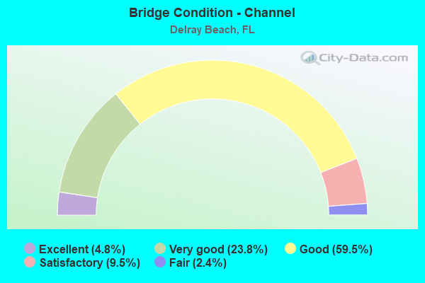
- Bridge Condition - Channel
- 4.8%Excellent
- 23.8%Very good
- 59.5%Good
- 9.5%Satisfactory
- 2.4%Fair
Find on map >> Show street view
Structure Number: 930026, Location: 0.3MI E OF US-1 (Lat: 26.474072, Lng: -80.062131), Route carried "on" structure: County highway , Year Built: 1949, Year Reconstructed: 2010, Status: Posted for load, Structure Length: 8.23m (27.00ft), Average Daily Traffic: 8,368 (year 2021), Truck Traffic: 4%, Average Future Daily Traffic: 10,042 (year 2042), Design Load: H 15, Features Intersected: Intracoastal Waterway, Facility Carried by Structure: G BUSH BLVD(NE8TH)
Minimum Vertical Clearance: 30+ m (98+ ft), Kilometerpoint: 0.554, Lanes on structure: 2, Owner: County Highway Agency, Approaching Roadway Width: 6.7m (22.0ft), Navigation Control: Yes ( Vertical Clearance: 1.8m (5.9ft), Horizontal Clearance: 28.0m (91.9ft)), Material/Design: Steel, Design/Construction: Movable - Bascule, Number Of Spans In Main Unit: 1, Number Of Approach Spans: 4, Length of Maximum Span: 37.6m (123.4ft), Curb or Sidewalk Widths: Left: 1.5m (4.9ft), Right: 1.5m (4.9ft), Curb-To-Curb Width: 6.7m (22.0ft), Out-to-Out Width: 10.7m (35.1ft)
Condition: Deck: Good, Superstructure: Satisfactory, Substructure: Good, Channel: Good, Operating Rating: 23.9 metric tons, Method Used To Determine Operating Rating: Load Factor (LF), Inventory Rating: 14.1 metric tons, Method Used To Determine Inventory Rating: Load Factor (LF), Structural Evaluation: High priority of corrective action, Deck Geometry: High priority of replacement, Waterway Adequacy: Better than present minimum criteria, Approach Roadway Alignment: Equal to present desirable criteria, Bridge Posting: Required (Relationship of Operating Rating to Maximum Legal Load: 10.0 - 19.9% below), Designated Inspection Frequency: Every 24 months, Critical Feature Inspection Frequency: Every 24 months, Underwater Inspection Frequency: Every 24 months, Other Special Inspection Frequency: Every 12 months, Inspection Date: May 2021, Critical Feature Inspection Date: May 2021, Underwater Inspection Date: May 2021, Other Special Inspection Date: May 2021, Deck Structure Type: Open Grating
Find on map >> Show street view
Structure Number: 930032, Location: 300' E of FL Turnpike (Lat: 26.453606, Lng: -80.171797), Route carried "on" structure: State highway 806, Year Built: 1965, Year Reconstructed: 2001, Status: Open, Structure Length: 1.86m (6.10ft), Average Daily Traffic: 36,500 (year 2021), Truck Traffic: 6%, Average Future Daily Traffic: 63,328 (year 2042), Design Load: HS 20+Mod, Features Intersected: E-2-E Canal
Minimum Vertical Clearance: 30+ m (98+ ft), Kilometerpoint: 3.269, Lanes on structure: 7, Base Highway Network: Yes, Owner: State Highway Agency, Approaching Roadway Width: 25.0m (82.0ft), Skew: 20 degrees, Material/Design: Concrete, Design/Construction: Slab, Number Of Spans In Main Unit: 3, Length of Maximum Span: 6.2m (20.3ft), Curb or Sidewalk Widths: Left: 1.8m (5.9ft), Right: 1.8m (5.9ft), Curb-To-Curb Width: 36.3m (119.1ft), Out-to-Out Width: 37.9m (124.3ft)
Condition: Deck: Very good, Superstructure: Very good, Substructure: Good, Channel: Satisfactory, Operating Rating: 40.2 metric tons, Method Used To Determine Operating Rating: Load and Resistance Factor (LRFR), Inventory Rating: 32.7 metric tons, Method Used To Determine Inventory Rating: Load and Resistance Factor (LRFR), Structural Evaluation: Better than present minimum criteria, Deck Geometry: Superior to present desirable criteria, Waterway Adequacy: Superior to present desirable criteria, Approach Roadway Alignment: Equal to present desirable criteria, Designated Inspection Frequency: Every 24 months, Underwater Inspection Frequency: Every 24 months, Inspection Date: July 2021, Underwater Inspection Date: July 2021, Deck Structure Type: Concrete Cast-file-Place
Find on map >> Show street view
Structure Number: 930064, Location: Between SR-A1A & SR-5 (Lat: 26.461614, Lng: -80.064242), Route carried "on" structure: State highway 806, Year Built: 1952, Status: Open, Structure Length: 7.17m (23.52ft), Average Daily Traffic: 12,300 (year 2021), Truck Traffic: 16%, Average Future Daily Traffic: 21,340 (year 2042), Design Load: H 15, Features Intersected: Intracoastal Waterway, Facility Carried by Structure: Atlantic Avenue
Minimum Vertical Clearance: 30+ m (98+ ft), Kilometerpoint: 14.186, Lanes on structure: 4, Owner: State Highway Agency, Approaching Roadway Width: 12.1m (39.7ft), Navigation Control: Yes ( Vertical Clearance: 2.4m (7.9ft), Horizontal Clearance: 27.4m (89.9ft)), Material/Design: Steel, Design/Construction: Movable - Bascule, Number Of Spans In Main Unit: 1, Number Of Approach Spans: 2, Length of Maximum Span: 31.4m (103.0ft), Curb or Sidewalk Widths: Left: 1.6m (5.2ft), Right: 1.6m (5.2ft), Curb-To-Curb Width: 12.1m (39.7ft), Out-to-Out Width: 16.3m (53.5ft)
Condition: Deck: Good, Superstructure: Good, Substructure: Good, Channel: Good, Operating Rating: 38.2 metric tons, Method Used To Determine Operating Rating: Load Testing, Inventory Rating: 22.9 metric tons, Method Used To Determine Inventory Rating: Load Testing, Structural Evaluation: Somewhat better than minimum adequacy, Deck Geometry: High priority of replacement, Waterway Adequacy: Superior to present desirable criteria, Approach Roadway Alignment: Better than present minimum criteria, Designated Inspection Frequency: Every 24 months, Critical Feature Inspection Frequency: Every 24 months, Underwater Inspection Frequency: Every 24 months, Other Special Inspection Frequency: Every 12 months, Inspection Date: July 2020, Critical Feature Inspection Date: July 2020, Underwater Inspection Date: July 2020, Other Special Inspection Date: July 2021, Deck Structure Type: Open Grating
Find on map >> Show street view
Structure Number: 930069, Location: Just W. of Congress Ave. (Lat: 26.459350, Lng: -80.096483), Route carried "on" structure: State highway 806, Year Built: 1966, Year Reconstructed: 1994, Status: Open, Structure Length: 3.89m (12.76ft), Average Daily Traffic: 37,500 (year 2021), Truck Traffic: 7%, Average Future Daily Traffic: 65,062 (year 2042), Design Load: HS 20+Mod, Features Intersected: El Rio Canal E-4
Minimum Vertical Clearance: 30+ m (98+ ft), Kilometerpoint: 10.868, Lanes on structure: 6, Owner: State Highway Agency, Approaching Roadway Width: 26.3m (86.3ft), Skew: 21 degrees, Material/Design: Prestressed concrete, Design/Construction: Stringer/Multi-beam, Number Of Spans In Main Unit: 3, Length of Maximum Span: 13.0m (42.7ft), Curb or Sidewalk Widths: Left: 1.8m (5.9ft), Right: 1.8m (5.9ft), Curb-To-Curb Width: 28.8m (94.5ft), Out-to-Out Width: 33.4m (109.6ft)
Condition: Deck: Good, Superstructure: Good, Substructure: Good, Channel: Good, Operating Rating: 61.6 metric tons, Method Used To Determine Operating Rating: Load Factor (LF), Inventory Rating: 36.9 metric tons, Method Used To Determine Inventory Rating: Load Factor (LF), Structural Evaluation: Better than present minimum criteria, Deck Geometry: Superior to present desirable criteria, Waterway Adequacy: Superior to present desirable criteria, Approach Roadway Alignment: Better than present minimum criteria, Designated Inspection Frequency: Every 24 months, Underwater Inspection Frequency: Every 24 months, Inspection Date: July 2021, Underwater Inspection Date: July 2021, Deck Structure Type: Concrete Cast-file-Place
Find on map >> Show street view
Structure Number: 930184, Location: 1 mile S of Linton Blvd (Lat: 26.424556, Lng: -80.090250), Route carried "on" structure: Interstate 95, Year Built: 1972, Year Reconstructed: 1993, Status: Open, Structure Length: 6.40m (21.00ft), Average Daily Traffic: 114,000 (year 2021), Truck Traffic: 8%, Average Future Daily Traffic: 197,790 (year 2042), Design Load: HS 20+Mod, Features Intersected: C-15 Canal
Minimum Vertical Clearance: 30+ m (98+ ft), Kilometerpoint: 11.824, Lanes on structure: 4, Base Highway Network: Yes, Owner: State Highway Agency, Approaching Roadway Width: 22.6m (74.1ft), Material/Design: Concrete continuous, Design/Construction: Slab, Number Of Spans In Main Unit: 9, Length of Maximum Span: 7.6m (24.9ft), Curb-To-Curb Width: 22.6m (74.1ft), Out-to-Out Width: 23.5m (77.1ft)
Condition: Deck: Good, Superstructure: Good, Substructure: Good, Channel: Very good, Operating Rating: 42.1 metric tons, Method Used To Determine Operating Rating: Load and Resistance Factor (LRFR), Inventory Rating: 32.7 metric tons, Method Used To Determine Inventory Rating: Load and Resistance Factor (LRFR), Structural Evaluation: Better than present minimum criteria, Deck Geometry: Superior to present desirable criteria, Waterway Adequacy: Superior to present desirable criteria, Approach Roadway Alignment: Equal to present desirable criteria, Designated Inspection Frequency: Every 24 months, Underwater Inspection Frequency: Every 24 months, Inspection Date: April 2021, Underwater Inspection Date: April 2021, Deck Structure Type: Concrete Cast-file-Place, Wearing Surface/Protective System: Wearing Surface: Bituminous
Find on map >> Show street view
Structure Number: 930215, Location: 2.0 MI SOUTH OF SR-806 (Lat: 26.423994, Lng: -80.171664), Route carried "on" structure: State highway 91, Year Built: 1956, Year Reconstructed: 2002, Status: Open, Structure Length: 2.50m (8.20ft), Average Daily Traffic: 90,100 (year 2021), Truck Traffic: 13%, Average Future Daily Traffic: 156,324 (year 2042), Design Load: HS 20+Mod, Features Intersected: LATERAL CANAL #38
Minimum Vertical Clearance: 30+ m (98+ ft), Kilometerpoint: 10.598, Lanes on structure: 6, Base Highway Network: Yes, Toll: On toll road, Owner: State Toll Authority, Approaching Roadway Width: 33.8m (110.9ft), Skew: 30 degrees, Material/Design: Concrete, Design/Construction: Tee Beam, Number Of Spans In Main Unit: 1, Number Of Approach Spans: 2, Length of Maximum Span: 14.6m (47.9ft), Curb-To-Curb Width: 33.8m (110.9ft), Out-to-Out Width: 35.4m (116.1ft)
Condition: Deck: Good, Superstructure: Good, Substructure: Good, Channel: Very good, Operating Rating: 26.7 metric tons, Method Used To Determine Operating Rating: Load and Resistance Factor (LRFR), Inventory Rating: 20.6 metric tons, Method Used To Determine Inventory Rating: Load and Resistance Factor (LRFR), Structural Evaluation: Somewhat better than minimum adequacy, Deck Geometry: Superior to present desirable criteria, Waterway Adequacy: Equal to present minimum criteria, Approach Roadway Alignment: Equal to present desirable criteria, Length Of Structure Improvement: 2.47m (8.10ft), Designated Inspection Frequency: Every 24 months, Inspection Date: October 2021, Bridge Improvement Cost: $180,000, Total Project Cost: $180,000, Deck Structure Type: Concrete Cast-file-Place, Wearing Surface/Protective System: Wearing Surface: Bituminous, Deck Protection: Other
Find on map >> Show street view
Structure Number: 93024, Location: 1/2 mile W of SR-809 (Lat: 26.457778, Lng: -80.130672), Route carried "on" structure: State highway 806, Year Built: 1966, Year Reconstructed: 1995, Status: Open, Structure Length: 1.60m (5.25ft), Average Daily Traffic: 40,500 (year 2020), Truck Traffic: 4%, Average Future Daily Traffic: 70,268 (year 2042), Design Load: HS 20+Mod, Features Intersected: E-3 Canal, Facility Carried by Structure: West Atlantic Ave.
Minimum Vertical Clearance: 30+ m (98+ ft), Kilometerpoint: 7.488, Lanes on structure: 7, Base Highway Network: Yes, Owner: State Highway Agency, Approaching Roadway Width: 30.0m (98.4ft), Skew: 20 degrees, Material/Design: Concrete, Design/Construction: Slab, Number Of Spans In Main Unit: 3, Length of Maximum Span: 6.1m (20.0ft), Curb or Sidewalk Widths: Left: 1.8m (5.9ft), Right: 1.8m (5.9ft), Curb-To-Curb Width: 30.0m (98.4ft), Out-to-Out Width: 34.6m (113.5ft)
Condition: Deck: Good, Superstructure: Good, Substructure: Good, Channel: Satisfactory, Operating Rating: 52.9 metric tons, Method Used To Determine Operating Rating: Load Factor (LF), Inventory Rating: 31.7 metric tons, Method Used To Determine Inventory Rating: Load Factor (LF), Structural Evaluation: Better than present minimum criteria, Deck Geometry: Equal to present minimum criteria, Waterway Adequacy: Superior to present desirable criteria, Approach Roadway Alignment: Equal to present desirable criteria, Designated Inspection Frequency: Every 24 months, Underwater Inspection Frequency: Every 24 months, Inspection Date: June 2020, Underwater Inspection Date: June 2020, Deck Structure Type: Concrete Cast-file-Place
Find on map >> Show street view
Structure Number: 930322, Location: 0.2MI EAST OF US-1 (SR-5) (Lat: 26.439769, Lng: -80.065208), Route carried "on" structure: County highway , Year Built: 1981, Status: Open, Structure Length: 42.39m (139.07ft), Average Daily Traffic: 20,500 (year 2021), Truck Traffic: 9%, Average Future Daily Traffic: 26,400 (year 2042), Design Load: HS 20, Features Intersected: INTRACOASTAL WATERWAY, Facility Carried by Structure: LINTON BLVD.
Minimum Vertical Clearance: 5.46m (17.91ft), Kilometerpoint: 2.512, Lanes on structure: 5, Owner: County Highway Agency, Approaching Roadway Width: 23.7m (77.8ft), Skew: 20 degrees, Navigation Control: Yes ( Vertical Clearance: 7.9m (25.9ft), Horizontal Clearance: 27.9m (91.5ft)), Material/Design: Steel, Design/Construction: Movable - Bascule, Number Of Spans In Main Unit: 1, Number Of Approach Spans: 19, Length of Maximum Span: 35.2m (115.5ft), Curb or Sidewalk Widths: Left: 1.6m (5.2ft), Right: 3.6m (11.8ft), Curb-To-Curb Width: 21.1m (69.2ft), Out-to-Out Width: 31.2m (102.4ft)
Condition: Deck: Satisfactory, Superstructure: Satisfactory, Substructure: Satisfactory, Channel: Good, Operating Rating: 41.0 metric tons, Method Used To Determine Operating Rating: Allowable Stress (AS), Inventory Rating: 29.4 metric tons, Method Used To Determine Inventory Rating: Allowable Stress (AS), Structural Evaluation: Equal to present minimum criteria, Deck Geometry: Somewhat better than minimum adequacy, Waterway Adequacy: Equal to present desirable criteria, Approach Roadway Alignment: Equal to present desirable criteria, Designated Inspection Frequency: Every 24 months, Critical Feature Inspection Frequency: Every 24 months, Underwater Inspection Frequency: Every 24 months, Other Special Inspection Frequency: Every 12 months, Inspection Date: July 2020, Critical Feature Inspection Date: July 2020, Underwater Inspection Date: July 2020, Other Special Inspection Date: July 2021, Deck Structure Type: Open Grating
Find on map >> Show street view
Structure Number: 930442, Location: 1.3mi. South of Linton (Lat: 26.420678, Lng: -80.090406), Route carried "on" structure: Ramp Interstate 95, Year Built: 1993, Status: Open, Structure Length: 9.13m (29.95ft), Average Daily Traffic: 24,000 (year 2021), Truck Traffic: 7%, Average Future Daily Traffic: 41,640 (year 2042), Design Load: HS 20+Mod, Features Intersected: I-95 (SR-9), Facility Carried by Structure: Peninsula Corp Dr
Minimum Vertical Clearance: 30+ m (98+ ft), Kilometerpoint: 0.259, Lanes on structure: 4, Lanes under structure: 8, Owner: State Highway Agency, Approaching Roadway Width: 23.5m (77.1ft), Skew: 20 degrees, Material/Design: Prestressed concrete, Design/Construction: Stringer/Multi-beam, Number Of Spans In Main Unit: 2, Length of Maximum Span: 40.3m (132.2ft), Curb-To-Curb Width: 22.9m (75.1ft), Out-to-Out Width: 23.8m (78.1ft)
Condition: Deck: Good, Superstructure: Very good, Substructure: Very good, Inventory Rating: 63.6 metric tons, Method Used To Determine Inventory Rating: Load Factor (LF), Structural Evaluation: Equal to present desirable criteria, Deck Geometry: Superior to present desirable criteria, Underclear: Meets minimum limits, Approach Roadway Alignment: Better than present minimum criteria, Designated Inspection Frequency: Every 24 months, Inspection Date: June 2021, Deck Structure Type: Concrete Cast-file-Place
Find on map >> Show street view
Structure Number: 930443, Location: 1.3 mile S of Linton Rd. (Lat: 26.420642, Lng: -80.090881), Route carried "on" structure: Ramp Interstate 95, Year Built: 1993, Status: Open, Structure Length: 3.51m (11.52ft), Average Daily Traffic: 24,000 (year 2021), Truck Traffic: 7%, Average Future Daily Traffic: 41,640 (year 2042), Design Load: HS 20+Mod, Features Intersected: CSX Railroad, Facility Carried by Structure: Peninsula Corp Dr
Minimum Vertical Clearance: 30+ m (98+ ft), Kilometerpoint: 0.211, Lanes on structure: 6, Owner: State Highway Agency, Approaching Roadway Width: 30.2m (99.1ft), Skew: 20 degrees, Material/Design: Prestressed concrete, Design/Construction: Stringer/Multi-beam, Number Of Spans In Main Unit: 1, Length of Maximum Span: 35.1m (115.2ft), Curb-To-Curb Width: 30.2m (99.1ft), Out-to-Out Width: 31.1m (102.0ft)
Condition: Deck: Good, Superstructure: Very good, Substructure: Good, Inventory Rating: 59.8 metric tons, Method Used To Determine Inventory Rating: Load Factor (LF), Structural Evaluation: Better than present minimum criteria, Deck Geometry: Superior to present desirable criteria, Underclear: Superior to present desirable criteria, Approach Roadway Alignment: Better than present minimum criteria, Designated Inspection Frequency: Every 24 months, Inspection Date: June 2021, Deck Structure Type: Concrete Cast-file-Place
Find on map >> Show street view
Structure Number: 930444, Location: 0.85 mile South of Linton (Lat: 26.424556, Lng: -80.090472), Route carried "on" structure: Ramp Interstate 95, Year Built: 1993, Status: Open, Structure Length: 6.63m (21.75ft), Average Daily Traffic: 7,700 (year 2021), Truck Traffic: 5%, Average Future Daily Traffic: 13,360 (year 2042), Design Load: HS 20+Mod, Features Intersected: C-15 Canal
Minimum Vertical Clearance: 30+ m (98+ ft), Kilometerpoint: 0.080, Lanes on structure: 2, Owner: State Highway Agency, Approaching Roadway Width: 12.2m (40.0ft), Material/Design: Concrete continuous, Design/Construction: Slab, Number Of Spans In Main Unit: 9, Length of Maximum Span: 7.6m (24.9ft), Curb-To-Curb Width: 12.2m (40.0ft), Out-to-Out Width: 13.1m (43.0ft)
Condition: Deck: Good, Superstructure: Good, Substructure: Good, Channel: Good, Operating Rating: 53.9 metric tons, Method Used To Determine Operating Rating: Load Factor (LF), Inventory Rating: 32.4 metric tons, Method Used To Determine Inventory Rating: Load Factor (LF), Structural Evaluation: Better than present minimum criteria, Deck Geometry: Superior to present desirable criteria, Waterway Adequacy: Superior to present desirable criteria, Approach Roadway Alignment: Equal to present desirable criteria, Designated Inspection Frequency: Every 24 months, Underwater Inspection Frequency: Every 24 months, Inspection Date: April 2021, Underwater Inspection Date: April 2021, Deck Structure Type: Concrete Cast-file-Place
Find on map >> Show street view
Structure Number: 930445, Location: 1 mile S of Linton Blvd (Lat: 26.424556, Lng: -80.089778), Route carried "on" structure: Interstate 95, Year Built: 1993, Status: Open, Structure Length: 6.40m (21.00ft), Average Daily Traffic: 114,000 (year 2021), Truck Traffic: 8%, Average Future Daily Traffic: 197,790 (year 2042), Design Load: HS 20+Mod, Features Intersected: C-15 Canal
Minimum Vertical Clearance: 30+ m (98+ ft), Kilometerpoint: 11.824, Lanes on structure: 5, Base Highway Network: Yes, Owner: State Highway Agency, Approaching Roadway Width: 22.6m (74.1ft), Material/Design: Concrete continuous, Design/Construction: Slab, Number Of Spans In Main Unit: 9, Length of Maximum Span: 7.6m (24.9ft), Curb-To-Curb Width: 33.6m (110.2ft), Out-to-Out Width: 34.1m (111.9ft)
Condition: Deck: Good, Superstructure: Good, Substructure: Good, Channel: Good, Operating Rating: 50.3 metric tons, Method Used To Determine Operating Rating: Load and Resistance Factor (LRFR), Inventory Rating: 38.8 metric tons, Method Used To Determine Inventory Rating: Load and Resistance Factor (LRFR), Structural Evaluation: Better than present minimum criteria, Deck Geometry: Superior to present desirable criteria, Waterway Adequacy: Superior to present desirable criteria, Approach Roadway Alignment: Equal to present desirable criteria, Designated Inspection Frequency: Every 24 months, Underwater Inspection Frequency: Every 24 months, Inspection Date: April 2021, Underwater Inspection Date: April 2021, Deck Structure Type: Concrete Cast-file-Place
Find on map >> Show street view
Structure Number: 930455, Location: 2 miles N of Atlantic Ave (Lat: 26.483611, Lng: -80.084639), Route carried "on" structure: Interstate 95, Year Built: 1998, Status: Open, Structure Length: 3.47m (11.38ft), Average Daily Traffic: 179,596 (year 2021), Truck Traffic: 8%, Average Future Daily Traffic: 311,599 (year 2042), Design Load: HS 20+Mod, Features Intersected: Lateral Canal 30
Minimum Vertical Clearance: 30+ m (98+ ft), Kilometerpoint: 18.451, Lanes on structure: 10, Base Highway Network: Yes, Owner: State Highway Agency, Approaching Roadway Width: 57.9m (190.0ft), Skew: 31 degrees, Material/Design: Prestressed concrete, Design/Construction: Slab, Number Of Spans In Main Unit: 3, Length of Maximum Span: 13.1m (43.0ft), Curb-To-Curb Width: 61.6m (202.1ft), Out-to-Out Width: 63.1m (207.0ft)
Condition: Deck: Good, Superstructure: Good, Substructure: Good, Channel: Very good, Operating Rating: 48.6 metric tons, Method Used To Determine Operating Rating: Load Factor (LF), Inventory Rating: 37.8 metric tons, Method Used To Determine Inventory Rating: Load Factor (LF), Structural Evaluation: Better than present minimum criteria, Deck Geometry: Superior to present desirable criteria, Waterway Adequacy: Superior to present desirable criteria, Approach Roadway Alignment: Equal to present desirable criteria, Designated Inspection Frequency: Every 24 months, Underwater Inspection Frequency: Every 24 months, Inspection Date: October 2021, Underwater Inspection Date: October 2021, Deck Structure Type: Concrete Precast Panels, Wearing Surface/Protective System: Wearing Surface: Bituminous
Find on map >> Show street view
Structure Number: 93049, Location: 2.7 miles N of SR 806 (Lat: 26.499694, Lng: -80.078792), Route carried "on" structure: Interstate 95, Year Built: 2002, Status: Open, Structure Length: 3.47m (11.38ft), Average Daily Traffic: 198,560 (year 2021), Truck Traffic: 6%, Average Future Daily Traffic: 344,502 (year 2042), Design Load: HS 20+Mod, Features Intersected: Lake Ida Canal E-4
Minimum Vertical Clearance: 30+ m (98+ ft), Kilometerpoint: 20.300, Lanes on structure: 10, Base Highway Network: Yes, Owner: State Highway Agency, Approaching Roadway Width: 53.7m (176.2ft), Skew: 13 degrees, Material/Design: Prestressed concrete, Design/Construction: Stringer/Multi-beam, Number Of Spans In Main Unit: 3, Length of Maximum Span: 11.6m (38.1ft), Curb-To-Curb Width: 53.7m (176.2ft), Out-to-Out Width: 55.3m (181.4ft)
Condition: Deck: Good, Superstructure: Very good, Substructure: Good, Channel: Good, Operating Rating: 77.4 metric tons, Method Used To Determine Operating Rating: Load Factor (LF), Inventory Rating: 46.4 metric tons, Method Used To Determine Inventory Rating: Load Factor (LF), Structural Evaluation: Better than present minimum criteria, Deck Geometry: Superior to present desirable criteria, Waterway Adequacy: Somewhat better than minimum adequacy, Approach Roadway Alignment: Equal to present desirable criteria, Designated Inspection Frequency: Every 24 months, Underwater Inspection Frequency: Every 24 months, Inspection Date: April 2021, Underwater Inspection Date: April 2021, Deck Structure Type: Concrete Cast-file-Place
Find on map >> Show street view
Structure Number: 930495, Location: E Congress Ave & N SR 806 (Lat: 26.471364, Lng: -80.088906), Route carried "on" structure: Interstate 95, Year Built: 2004, Status: Open, Structure Length: 3.85m (12.63ft), Average Daily Traffic: 89,798 (year 2020), Truck Traffic: 8%, Average Future Daily Traffic: 155,800 (year 2042), Design Load: HS 20+Mod, Features Intersected: Lake Ida Road
Minimum Vertical Clearance: 30+ m (98+ ft), Kilometerpoint: 17.059, Lanes on structure: 5, Lanes under structure: 5, Base Highway Network: Yes, Owner: State Highway Agency, Approaching Roadway Width: 25.6m (84.0ft), Skew: 1 degrees, Material/Design: Prestressed concrete, Design/Construction: Stringer/Multi-beam, Number Of Spans In Main Unit: 1, Length of Maximum Span: 38.5m (126.3ft), Curb-To-Curb Width: 26.7m (87.6ft), Out-to-Out Width: 27.6m (90.6ft)
Condition: Deck: Good, Superstructure: Good, Substructure: Good, Inventory Rating: 64.4 metric tons, Method Used To Determine Inventory Rating: Load Factor (LF), Structural Evaluation: Better than present minimum criteria, Deck Geometry: Superior to present desirable criteria, Underclear: Superior to present desirable criteria, Approach Roadway Alignment: Equal to present desirable criteria, Designated Inspection Frequency: Every 24 months, Inspection Date: July 2020, Deck Structure Type: Concrete Cast-file-Place
Find on map >> Show street view
Structure Number: 930496, Location: E Congress Ave & N SR 806 (Lat: 26.471472, Lng: -80.089167), Route carried "on" structure: Interstate 95, Year Built: 2004, Status: Open, Structure Length: 3.85m (12.63ft), Average Daily Traffic: 89,798 (year 2020), Truck Traffic: 8%, Average Future Daily Traffic: 155,800 (year 2042), Design Load: HS 20+Mod, Features Intersected: Lake Ida Road
Minimum Vertical Clearance: 30+ m (98+ ft), Kilometerpoint: 17.059, Lanes on structure: 6, Lanes under structure: 5, Base Highway Network: Yes, Owner: State Highway Agency, Approaching Roadway Width: 25.6m (84.0ft), Skew: 1 degrees, Material/Design: Prestressed concrete, Design/Construction: Stringer/Multi-beam, Number Of Spans In Main Unit: 1, Length of Maximum Span: 38.5m (126.3ft), Curb-To-Curb Width: 30.3m (99.4ft), Out-to-Out Width: 31.2m (102.4ft)
Condition: Deck: Very good, Superstructure: Good, Substructure: Good, Inventory Rating: 64.4 metric tons, Method Used To Determine Inventory Rating: Load Factor (LF), Structural Evaluation: Better than present minimum criteria, Deck Geometry: Superior to present desirable criteria, Underclear: Superior to present desirable criteria, Approach Roadway Alignment: Equal to present desirable criteria, Designated Inspection Frequency: Every 24 months, Inspection Date: July 2020, Deck Structure Type: Concrete Cast-file-Place
Find on map >> Show street view
Structure Number: 930497, Location: 0.5 mi N of Atlantic Ave (Lat: 26.469283, Lng: -80.089189), Route carried "on" structure: Interstate 95, Year Built: 2004, Status: Open, Structure Length: 6.83m (22.41ft), Average Daily Traffic: 89,798 (year 2020), Truck Traffic: 8%, Average Future Daily Traffic: 155,800 (year 2042), Design Load: HS 20+Mod, Features Intersected: Depot Ave & El Rio Canal
Minimum Vertical Clearance: 30+ m (98+ ft), Kilometerpoint: 16.805, Lanes on structure: 6, Lanes under structure: 2, Base Highway Network: Yes, Owner: State Highway Agency, Approaching Roadway Width: 30.1m (98.8ft), Skew: 1 degrees, Material/Design: Prestressed concrete, Design/Construction: Stringer/Multi-beam, Number Of Spans In Main Unit: 2, Length of Maximum Span: 41.2m (135.2ft), Curb-To-Curb Width: 30.1m (98.8ft), Out-to-Out Width: 31.1m (102.0ft)
Condition: Deck: Good, Superstructure: Very good, Substructure: Good, Channel: Very good, Operating Rating: 87.0 metric tons, Method Used To Determine Operating Rating: Load Factor (LF), Inventory Rating: 52.6 metric tons, Method Used To Determine Inventory Rating: Load Factor (LF), Structural Evaluation: Better than present minimum criteria, Deck Geometry: Superior to present desirable criteria, Underclear: Superior to present desirable criteria, Waterway Adequacy: Superior to present desirable criteria, Approach Roadway Alignment: Equal to present desirable criteria, Designated Inspection Frequency: Every 24 months, Inspection Date: September 2020, Deck Structure Type: Concrete Cast-file-Place
Find on map >> Show street view
Structure Number: 930498, Location: 0.5 mi N of Atlantic Ave (Lat: 26.469167, Lng: -80.089486), Route carried "on" structure: Interstate 95, Year Built: 2004, Status: Open, Structure Length: 6.83m (22.41ft), Average Daily Traffic: 89,798 (year 2020), Truck Traffic: 8%, Average Future Daily Traffic: 155,800 (year 2042), Design Load: HS 20+Mod, Features Intersected: Depot Ave & El Rio Canal
Minimum Vertical Clearance: 30+ m (98+ ft), Kilometerpoint: 16.805, Lanes on structure: 6, Lanes under structure: 2, Base Highway Network: Yes, Owner: State Highway Agency, Approaching Roadway Width: 30.1m (98.8ft), Skew: 1 degrees, Material/Design: Prestressed concrete, Design/Construction: Stringer/Multi-beam, Number Of Spans In Main Unit: 2, Length of Maximum Span: 41.2m (135.2ft), Curb-To-Curb Width: 30.1m (98.8ft), Out-to-Out Width: 31.1m (102.0ft)
Condition: Deck: Good, Superstructure: Good, Substructure: Good, Channel: Good, Operating Rating: 87.0 metric tons, Method Used To Determine Operating Rating: Load Factor (LF), Inventory Rating: 52.6 metric tons, Method Used To Determine Inventory Rating: Load Factor (LF), Structural Evaluation: Better than present minimum criteria, Deck Geometry: Superior to present desirable criteria, Underclear: Superior to present desirable criteria, Waterway Adequacy: Superior to present desirable criteria, Approach Roadway Alignment: Equal to present desirable criteria, Designated Inspection Frequency: Every 24 months, Inspection Date: September 2020, Deck Structure Type: Concrete Cast-file-Place
Find on map >> Show street view
Structure Number: 930499, Location: 1.5 miles South of SR 806 (Lat: 26.439514, Lng: -80.089192), Route carried "on" structure: Interstate 95, Year Built: 2004, Status: Open, Structure Length: 5.80m (19.03ft), Average Daily Traffic: 110,000 (year 2020), Truck Traffic: 9%, Average Future Daily Traffic: 190,850 (year 2042), Design Load: HS 20+Mod, Features Intersected: CR 782 Linton Blvd
Minimum Vertical Clearance: 30+ m (98+ ft), Kilometerpoint: 13.490, Lanes on structure: 5, Lanes under structure: 10, Base Highway Network: Yes, Owner: State Highway Agency, Approaching Roadway Width: 26.6m (87.3ft), Material/Design: Prestressed concrete, Design/Construction: Stringer/Multi-beam, Number Of Spans In Main Unit: 2, Length of Maximum Span: 29.0m (95.1ft), Curb-To-Curb Width: 26.7m (87.6ft), Out-to-Out Width: 27.6m (90.6ft)
Condition: Deck: Good, Superstructure: Very good, Substructure: Very good, Inventory Rating: 54.4 metric tons, Method Used To Determine Inventory Rating: Load Factor (LF), Structural Evaluation: Equal to present desirable criteria, Deck Geometry: Superior to present desirable criteria, Underclear: Better than present minimum criteria, Approach Roadway Alignment: Equal to present desirable criteria, Designated Inspection Frequency: Every 24 months, Inspection Date: October 2020, Deck Structure Type: Concrete Cast-file-Place
Find on map >> Show street view
Structure Number: 930501, Location: I 95 Over Lowson Blvd (Lat: 26.446894, Lng: -80.090139), Route carried "on" structure: Interstate 95, Year Built: 2004, Status: Open, Structure Length: 2.92m (9.58ft), Average Daily Traffic: 91,750 (year 2020), Truck Traffic: 7%, Average Future Daily Traffic: 159,186 (year 2042), Design Load: HS 20+Mod, Features Intersected: SW 10th St. Lowson Blvd
Minimum Vertical Clearance: 30+ m (98+ ft), Kilometerpoint: 14.326, Lanes on structure: 6, Lanes under structure: 4, Base Highway Network: Yes, Owner: State Highway Agency, Approaching Roadway Width: 26.7m (87.6ft), Material/Design: Prestressed concrete, Design/Construction: Stringer/Multi-beam, Number Of Spans In Main Unit: 1, Length of Maximum Span: 29.2m (95.8ft), Curb-To-Curb Width: 30.3m (99.4ft), Out-to-Out Width: 31.2m (102.4ft)
Condition: Deck: Good, Superstructure: Good, Substructure: Very good, Inventory Rating: 55.3 metric tons, Method Used To Determine Inventory Rating: Load Factor (LF), Structural Evaluation: Better than present minimum criteria, Deck Geometry: Superior to present desirable criteria, Underclear: Superior to present desirable criteria, Approach Roadway Alignment: Equal to present desirable criteria, Designated Inspection Frequency: Every 24 months, Inspection Date: October 2020, Deck Structure Type: Concrete Cast-file-Place
Find on map >> Show street view
Structure Number: 930502, Location: E Congress Ave & S SR 806 (Lat: 26.446875, Lng: -80.089811), Route carried "on" structure: Interstate 95, Year Built: 2004, Status: Open, Structure Length: 2.92m (9.58ft), Average Daily Traffic: 91,750 (year 2020), Truck Traffic: 7%, Average Future Daily Traffic: 159,186 (year 2042), Design Load: HS 20+Mod, Features Intersected: SW 10th St. Lowson Blvd
Minimum Vertical Clearance: 30+ m (98+ ft), Kilometerpoint: 14.326, Lanes on structure: 6, Lanes under structure: 4, Base Highway Network: Yes, Owner: State Highway Agency, Approaching Roadway Width: 26.7m (87.6ft), Material/Design: Prestressed concrete, Design/Construction: Stringer/Multi-beam, Number Of Spans In Main Unit: 1, Length of Maximum Span: 29.2m (95.8ft), Curb-To-Curb Width: 30.3m (99.4ft), Out-to-Out Width: 31.2m (102.4ft)
Condition: Deck: Good, Superstructure: Good, Substructure: Very good, Inventory Rating: 55.3 metric tons, Method Used To Determine Inventory Rating: Load Factor (LF), Structural Evaluation: Better than present minimum criteria, Deck Geometry: Superior to present desirable criteria, Underclear: Superior to present desirable criteria, Approach Roadway Alignment: Equal to present desirable criteria, Designated Inspection Frequency: Every 24 months, Inspection Date: October 2020, Deck Structure Type: Concrete Cast-file-Place
Find on map >> Show street view
Structure Number: 930503, Location: I-95 SR 806 interchange (Lat: 26.461667, Lng: -80.088681), Route carried "on" structure: Interstate 95, Year Built: 2004, Status: Open, Structure Length: 4.91m (16.11ft), Average Daily Traffic: 91,750 (year 2020), Truck Traffic: 7%, Average Future Daily Traffic: 159,186 (year 2042), Design Load: HS 20+Mod, Features Intersected: SR 806 W Atlantic Avenue
Minimum Vertical Clearance: 30+ m (98+ ft), Kilometerpoint: 15.978, Lanes on structure: 6, Lanes under structure: 9, Base Highway Network: Yes, Owner: State Highway Agency, Approaching Roadway Width: 26.7m (87.6ft), Material/Design: Prestressed concrete, Design/Construction: Stringer/Multi-beam, Number Of Spans In Main Unit: 2, Length of Maximum Span: 25.5m (83.7ft), Curb-To-Curb Width: 30.3m (99.4ft), Out-to-Out Width: 31.2m (102.4ft)
Condition: Deck: Very good, Superstructure: Good, Substructure: Very good, Operating Rating: 89.0 metric tons, Method Used To Determine Operating Rating: Load Factor (LF), Inventory Rating: 53.0 metric tons, Method Used To Determine Inventory Rating: Load Factor (LF), Structural Evaluation: Better than present minimum criteria, Deck Geometry: Superior to present desirable criteria, Underclear: Equal to present minimum criteria, Approach Roadway Alignment: Equal to present desirable criteria, Designated Inspection Frequency: Every 24 months, Inspection Date: May 2020, Deck Structure Type: Concrete Cast-file-Place
Find on map >> Show street view
Structure Number: 930504, Location: I-95/SR 806 interchange (Lat: 26.461389, Lng: -80.088333), Route carried "on" structure: Interstate 95, Year Built: 2004, Status: Open, Structure Length: 4.91m (16.11ft), Average Daily Traffic: 91,750 (year 2020), Truck Traffic: 7%, Average Future Daily Traffic: 159,186 (year 2042), Design Load: HS 20+Mod, Features Intersected: SR 806 (Atlantic Ave.)
Minimum Vertical Clearance: 30+ m (98+ ft), Kilometerpoint: 15.978, Lanes on structure: 5, Lanes under structure: 8, Base Highway Network: Yes, Owner: State Highway Agency, Approaching Roadway Width: 26.7m (87.6ft), Material/Design: Prestressed concrete, Design/Construction: Stringer/Multi-beam, Number Of Spans In Main Unit: 2, Length of Maximum Span: 25.5m (83.7ft), Curb-To-Curb Width: 26.7m (87.6ft), Out-to-Out Width: 27.6m (90.6ft)
Condition: Deck: Very good, Superstructure: Very good, Substructure: Very good, Operating Rating: 89.0 metric tons, Method Used To Determine Operating Rating: Load Factor (LF), Inventory Rating: 53.0 metric tons, Method Used To Determine Inventory Rating: Load Factor (LF), Structural Evaluation: Equal to present desirable criteria, Deck Geometry: Superior to present desirable criteria, Underclear: Equal to present minimum criteria, Approach Roadway Alignment: Equal to present desirable criteria, Designated Inspection Frequency: Every 24 months, Inspection Date: May 2020, Deck Structure Type: Concrete Cast-file-Place
Find on map >> Show street view
Structure Number: 931007, Location: 0.25 MI N OF ATLANTIC AVE (Lat: 26.457353, Lng: -80.176294), Route carried "on" structure: Ramp State highway 91, Year Built: 2006, Status: Open, Structure Length: 2.90m (9.51ft), Average Daily Traffic: 2,400 (year 2021), Truck Traffic: 13%, Average Future Daily Traffic: 4,164 (year 2042), Design Load: HL 93, Features Intersected: E-2W CANAL
Minimum Vertical Clearance: 30+ m (98+ ft), Kilometerpoint: 0.372, Lanes on structure: 1, Base Highway Network: Yes, Toll: On toll road, Owner: State Toll Authority, Approaching Roadway Width: 9.1m (29.9ft), Skew: 5 degrees, Material/Design: Prestressed concrete, Design/Construction: Stringer/Multi-beam, Number Of Spans In Main Unit: 1, Length of Maximum Span: 29.0m (95.1ft), Curb-To-Curb Width: 8.2m (26.9ft), Out-to-Out Width: 9.1m (29.9ft)
Condition: Deck: Very good, Superstructure: Very good, Substructure: Very good, Channel: Excellent, Operating Rating: 73.0 metric tons, Method Used To Determine Operating Rating: Load Factor (LF), Inventory Rating: 45.7 metric tons, Method Used To Determine Inventory Rating: Load Factor (LF), Structural Evaluation: Equal to present desirable criteria, Deck Geometry: Superior to present desirable criteria, Waterway Adequacy: Superior to present desirable criteria, Approach Roadway Alignment: Equal to present desirable criteria, Designated Inspection Frequency: Every 24 months, Inspection Date: September 2021, Deck Structure Type: Concrete Cast-file-Place
Find on map >> Show street view
Structure Number: 931008, Location: 0.25 MI N OF ATLANTIC AVE (Lat: 26.457153, Lng: -80.176106), Route carried "on" structure: Ramp State highway 91, Year Built: 2006, Status: Open, Structure Length: 2.41m (7.91ft), Average Daily Traffic: 7,050 (year 2021), Truck Traffic: 13%, Average Future Daily Traffic: 12,232 (year 2042), Design Load: HL 93, Features Intersected: E-2W CANAL
Minimum Vertical Clearance: 30+ m (98+ ft), Kilometerpoint: 0.344, Lanes on structure: 1, Base Highway Network: Yes, Toll: On toll road, Owner: State Toll Authority, Approaching Roadway Width: 10.7m (35.1ft), Material/Design: Prestressed concrete, Design/Construction: Stringer/Multi-beam, Number Of Spans In Main Unit: 1, Length of Maximum Span: 24.1m (79.1ft), Curb-To-Curb Width: 10.1m (33.1ft), Out-to-Out Width: 11.3m (37.1ft)
Condition: Deck: Very good, Superstructure: Very good, Substructure: Very good, Channel: Excellent, Operating Rating: 66.1 metric tons, Method Used To Determine Operating Rating: Load Factor (LF), Inventory Rating: 41.3 metric tons, Method Used To Determine Inventory Rating: Load Factor (LF), Structural Evaluation: Equal to present desirable criteria, Deck Geometry: Superior to present desirable criteria, Waterway Adequacy: Superior to present desirable criteria, Approach Roadway Alignment: Equal to present desirable criteria, Designated Inspection Frequency: Every 24 months, Inspection Date: September 2021, Deck Structure Type: Concrete Cast-file-Place
Find on map >> Show street view
Structure Number: 931009, Location: 2.12 MI NORTH OF SR-806 (Lat: 26.483708, Lng: -80.172569), Route carried "on" structure: State highway 91, Year Built: 2006, Status: Open, Structure Length: 2.65m (8.69ft), Average Daily Traffic: 83,000 (year 2021), Truck Traffic: 13%, Average Future Daily Traffic: 144,005 (year 2042), Design Load: HS 20+Mod, Features Intersected: LATERAL CANAL #30
Minimum Vertical Clearance: 30+ m (98+ ft), Kilometerpoint: 17.249, Lanes on structure: 6, Base Highway Network: Yes, Toll: On toll road, Owner: State Toll Authority, Approaching Roadway Width: 43.9m (144.0ft), Skew: 10 degrees, Material/Design: Prestressed concrete, Design/Construction: Stringer/Multi-beam, Number Of Spans In Main Unit: 1, Length of Maximum Span: 26.5m (86.9ft), Curb-To-Curb Width: 43.9m (144.0ft), Out-to-Out Width: 45.4m (149.0ft)
Condition: Deck: Very good, Superstructure: Very good, Substructure: Very good, Channel: Very good, Operating Rating: 80.1 metric tons, Method Used To Determine Operating Rating: Load Factor (LF), Inventory Rating: 50.0 metric tons, Method Used To Determine Inventory Rating: Load Factor (LF), Structural Evaluation: Equal to present desirable criteria, Deck Geometry: Superior to present desirable criteria, Waterway Adequacy: Equal to present minimum criteria, Approach Roadway Alignment: Equal to present desirable criteria, Designated Inspection Frequency: Every 24 months, Inspection Date: October 2021, Deck Structure Type: Concrete Cast-file-Place
Find on map >> Show street view
Structure Number: 934426, Location: 1.2 Mi N of Lake Ida Rd. (Lat: 26.483972, Lng: -80.138944), Route carried "on" structure: County highway , Year Built: 2020, Status: Open, Structure Length: 3.57m (11.71ft), Average Daily Traffic: 6,900 (year 2020), Truck Traffic: 2%, Average Future Daily Traffic: 11,971 (year 2042), Design Load: HL 93, Features Intersected: Canal L-30, Facility Carried by Structure: El Clair Ranch Rd.
Minimum Vertical Clearance: 30.45m (99.90ft), Kilometerpoint: 3.454, Lanes on structure: 2, Base Highway Network: Yes, Owner: County Highway Agency, Approaching Roadway Width: 10.4m (34.1ft), Material/Design: Prestressed concrete, Design/Construction: Slab, Number Of Spans In Main Unit: 3, Length of Maximum Span: 11.9m (39.0ft), Curb or Sidewalk Widths: Left: 1.8m (5.9ft), Right: 1.8m (5.9ft), Curb-To-Curb Width: 10.4m (34.1ft), Out-to-Out Width: 14.9m (48.9ft)
Condition: Deck: Excellent, Superstructure: Excellent, Substructure: Excellent, Channel: Very good, Operating Rating: 53.9 metric tons, Method Used To Determine Operating Rating: Load and Resistance Factor (LRFR), Inventory Rating: 41.5 metric tons, Method Used To Determine Inventory Rating: Load and Resistance Factor (LRFR), Structural Evaluation: Superior to present desirable criteria, Deck Geometry: Meets minimum limits, Waterway Adequacy: Equal to present desirable criteria, Approach Roadway Alignment: Equal to present desirable criteria, Designated Inspection Frequency: Every 24 months, Underwater Inspection Frequency: Every 24 months, Inspection Date: November 2020, Underwater Inspection Date: November 2020, Deck Structure Type: Concrete Precast Panels, Wearing Surface/Protective System: Wearing Surface: Integral Concrete
Find on map >> Show street view
Structure Number: 934427, Location: 0.5MI W OF MILITARY TRAIL (Lat: 26.475886, Lng: -80.130708), Route carried "on" structure: City street , Year Built: 1972, Status: Open, Structure Length: 1.84m (6.04ft), Average Daily Traffic: 2,500 (year 2020), Truck Traffic: 7%, Average Future Daily Traffic: 4,337 (year 2042), Design Load: HS 20, Features Intersected: LWDD E-3 CANAL, Facility Carried by Structure: VIA DELRAY BLVD
Minimum Vertical Clearance: 30+ m (98+ ft), Kilometerpoint: 0.819, Lanes on structure: 2, Owner: County Highway Agency, Approaching Roadway Width: 7.3m (24.0ft), Skew: 1 degrees, Material/Design: Prestressed concrete, Design/Construction: Slab, Number Of Spans In Main Unit: 3, Length of Maximum Span: 6.2m (20.3ft), Curb or Sidewalk Widths: Left: 1.2m (3.9ft), Right: 1.2m (3.9ft), Curb-To-Curb Width: 8.6m (28.2ft), Out-to-Out Width: 11.6m (38.1ft)
Condition: Deck: Good, Superstructure: Good, Substructure: Good, Channel: Good, Inventory Rating: 72.3 metric tons, Method Used To Determine Inventory Rating: Allowable Stress (AS), Structural Evaluation: Better than present minimum criteria, Deck Geometry: Meets minimum limits, Waterway Adequacy: Equal to present desirable criteria, Approach Roadway Alignment: Equal to present desirable criteria, Designated Inspection Frequency: Every 24 months, Underwater Inspection Frequency: Every 24 months, Inspection Date: March 2020, Underwater Inspection Date: March 2020, Deck Structure Type: Concrete Precast Panels, Wearing Surface/Protective System: Wearing Surface: Bituminous
Find on map >> Show street view
Structure Number: 934455, Location: 0.7MI N OF LAKE IDA ROAD (Lat: 26.483933, Lng: -80.114517), Route carried "on" structure: County highway , Year Built: 1964, Status: Open, Structure Length: 2.76m (9.06ft), Average Daily Traffic: 9,900 (year 2020), Truck Traffic: 3%, Average Future Daily Traffic: 17,176 (year 2042), Design Load: HS 20, Features Intersected: LWDD LAT 30 CANAL, Facility Carried by Structure: BARWICK RD
Minimum Vertical Clearance: 30+ m (98+ ft), Kilometerpoint: 2.902, Lanes on structure: 2, Owner: County Highway Agency, Approaching Roadway Width: 7.4m (24.3ft), Material/Design: Prestressed concrete, Design/Construction: Slab, Number Of Spans In Main Unit: 3, Length of Maximum Span: 9.2m (30.2ft), Curb or Sidewalk Widths: Left: 1.4m (4.6ft), Right: 1.4m (4.6ft), Curb-To-Curb Width: 8.6m (28.2ft), Out-to-Out Width: 12.5m (41.0ft)
Condition: Deck: Good, Superstructure: Good, Substructure: Good, Channel: Good, Inventory Rating: 57.5 metric tons, Method Used To Determine Inventory Rating: Allowable Stress (AS), Structural Evaluation: Better than present minimum criteria, Deck Geometry: High priority of replacement, Waterway Adequacy: Better than present minimum criteria, Approach Roadway Alignment: Equal to present desirable criteria, Designated Inspection Frequency: Every 24 months, Underwater Inspection Frequency: Every 24 months, Inspection Date: March 2020, Underwater Inspection Date: March 2020, Deck Structure Type: Concrete Precast Panels, Wearing Surface/Protective System: Wearing Surface: Bituminous
Find on map >> Show street view
Structure Number: 93447, Location: 0.4MI S OF LINTON BLVD (Lat: 26.424567, Lng: -80.092297), Route carried "on" structure: County highway 807, Year Built: 1969, Year Reconstructed: 1988, Status: Open, Structure Length: 5.79m (19.00ft), Average Daily Traffic: 25,000 (year 2020), Truck Traffic: 7%, Average Future Daily Traffic: 43,375 (year 2042), Design Load: HS 20, Features Intersected: C-15 CANAL, Facility Carried by Structure: CONGRESS AVE
Minimum Vertical Clearance: 30+ m (98+ ft), Kilometerpoint: 2.169, Lanes on structure: 7, Owner: County Highway Agency, Approaching Roadway Width: 25.3m (83.0ft), Skew: 20 degrees, Material/Design: Prestressed concrete, Design/Construction: Slab, Number Of Spans In Main Unit: 5, Length of Maximum Span: 11.6m (38.1ft), Curb or Sidewalk Widths: Left: 1.5m (4.9ft), Right: 2.4m (7.9ft), Curb-To-Curb Width: 28.5m (93.5ft), Out-to-Out Width: 35.5m (116.5ft)
Condition: Deck: Good, Superstructure: Good, Substructure: Good, Channel: Good, Operating Rating: 53.5 metric tons, Method Used To Determine Operating Rating: Load and Resistance Factor (LRFR), Inventory Rating: 41.5 metric tons, Method Used To Determine Inventory Rating: Load and Resistance Factor (LRFR), Structural Evaluation: Better than present minimum criteria, Deck Geometry: Somewhat better than minimum adequacy, Waterway Adequacy: Better than present minimum criteria, Approach Roadway Alignment: Better than present minimum criteria, Designated Inspection Frequency: Every 24 months, Underwater Inspection Frequency: Every 24 months, Inspection Date: April 2020, Underwater Inspection Date: April 2020, Deck Structure Type: Concrete Precast Panels, Wearing Surface/Protective System: Wearing Surface: Bituminous
Find on map >> Show street view
Structure Number: 934482, Location: 0.4 MI W OF CONGRESS AVE (Lat: 26.434153, Lng: -80.099231), Route carried "on" structure: City street , Year Built: 1988, Status: Open, Structure Length: 3.44m (11.29ft), Average Daily Traffic: 1,200 (year 2020), Truck Traffic: 1%, Average Future Daily Traffic: 2,082 (year 2042), Design Load: HS 20, Features Intersected: L.W.D.D. E-4 CANAL, Facility Carried by Structure: OLD GERMANTOWN RD
Minimum Vertical Clearance: 30+ m (98+ ft), Kilometerpoint: 1.595, Lanes on structure: 2, Owner: City or Municipal Highway Agency, Approaching Roadway Width: 7.1m (23.3ft), Material/Design: Prestressed concrete, Design/Construction: Slab, Number Of Spans In Main Unit: 5, Length of Maximum Span: 8.2m (26.9ft), Curb or Sidewalk Widths: Left: 1.7m (5.6ft), Right: 1.7m (5.6ft), Curb-To-Curb Width: 9.8m (32.2ft), Out-to-Out Width: 14.2m (46.6ft)
Condition: Deck: Fair, Superstructure: Fair, Substructure: Satisfactory, Channel: Good, Structural Evaluation: Somewhat better than minimum adequacy, Deck Geometry: Somewhat better than minimum adequacy, Waterway Adequacy: Better than present minimum criteria, Approach Roadway Alignment: Somewhat better than minimum adequacy, Designated Inspection Frequency: Every 24 months, Underwater Inspection Frequency: Every 24 months, Inspection Date: October 2020, Underwater Inspection Date: October 2020, Deck Structure Type: Concrete Precast Panels, Wearing Surface/Protective System: Wearing Surface: Bituminous
Find on map >> Show street view
Structure Number: 934483, Location: 0.8Mi W of JOG/CARTER RD. (Lat: 26.439236, Lng: -80.156836), Route carried "on" structure: County highway , Year Built: 1991, Status: Open, Structure Length: 1.53m (5.02ft), Average Daily Traffic: 2,000 (year 2020), Truck Traffic: 5%, Average Future Daily Traffic: 3,000 (year 2042), Design Load: HS 20, Features Intersected: DIRT FARM ROAD, Facility Carried by Structure: LINTON BLVD.
Minimum Vertical Clearance: 30+ m (98+ ft), Kilometerpoint: 0.000, Lanes on structure: 2, Owner: County Highway Agency, Approaching Roadway Width: 9.4m (30.8ft), Material/Design: Prestressed concrete, Design/Construction: Slab, Number Of Spans In Main Unit: 1, Length of Maximum Span: 15.3m (50.2ft), Curb or Sidewalk Widths: Left: 1.9m (6.2ft), Right: 0.0m, Curb-To-Curb Width: 13.2m (43.3ft), Out-to-Out Width: 16.0m (52.5ft)
Condition: Deck: Good, Superstructure: Good, Substructure: Good, Operating Rating: 43.5 metric tons, Method Used To Determine Operating Rating: Load Factor (LF), Inventory Rating: 26.3 metric tons, Method Used To Determine Inventory Rating: Load Factor (LF), Structural Evaluation: Equal to present minimum criteria, Deck Geometry: Better than present minimum criteria, Approach Roadway Alignment: Equal to present desirable criteria, Designated Inspection Frequency: Every 24 months, Inspection Date: June 2020, Deck Structure Type: Concrete Precast Panels, Wearing Surface/Protective System: Wearing Surface: Bituminous
Find on map >> Show street view
Structure Number: 934911, Location: 1.1MI S OF LINTON BLVD (Lat: 26.422633, Lng: -80.076356), Route carried "on" structure: County highway 811, Year Built: 1964, Status: Open, Structure Length: 5.49m (18.01ft), Average Daily Traffic: 8,900 (year 2020), Truck Traffic: 3%, Average Future Daily Traffic: 15,441 (year 2042), Design Load: HS 20, Features Intersected: C-15 CANAL, Facility Carried by Structure: OLD DIXIE HWY
Minimum Vertical Clearance: 30+ m (98+ ft), Kilometerpoint: 3.125, Lanes on structure: 2, Owner: County Highway Agency, Approaching Roadway Width: 7.3m (24.0ft), Material/Design: Prestressed concrete, Design/Construction: Stringer/Multi-beam, Number Of Spans In Main Unit: 3, Length of Maximum Span: 18.3m (60.0ft), Curb or Sidewalk Widths: Left: 1.0m (3.3ft), Right: 1.0m (3.3ft), Curb-To-Curb Width: 8.5m (27.9ft), Out-to-Out Width: 11.7m (38.4ft)
Condition: Deck: Good, Superstructure: Good, Substructure: Good, Channel: Good, Operating Rating: 75.3 metric tons, Method Used To Determine Operating Rating: Load Factor (LF), Inventory Rating: 45.4 metric tons, Method Used To Determine Inventory Rating: Load Factor (LF), Structural Evaluation: Better than present minimum criteria, Deck Geometry: High priority of replacement, Waterway Adequacy: Better than present minimum criteria, Approach Roadway Alignment: Equal to present desirable criteria, Designated Inspection Frequency: Every 24 months, Underwater Inspection Frequency: Every 24 months, Inspection Date: April 2020, Underwater Inspection Date: April 2020, Deck Structure Type: Concrete Cast-file-Place, Wearing Surface/Protective System: Wearing Surface: Bituminous
Find on map >> Show street view
Structure Number: 934918, Location: 1MI S. OF LINTON BLVD (Lat: 26.424183, Lng: -80.146592), Route carried "on" structure: County highway , Year Built: 1991, Status: Open, Structure Length: 2.74m (8.99ft), Average Daily Traffic: 33,000 (year 2020), Truck Traffic: 2%, Average Future Daily Traffic: 57,255 (year 2042), Design Load: HS 20, Features Intersected: L-38 CANAL, Facility Carried by Structure: JOG ROAD SB
Minimum Vertical Clearance: 30+ m (98+ ft), Kilometerpoint: 6.167, Lanes on structure: 3, Base Highway Network: Yes, Owner: County Highway Agency, Approaching Roadway Width: 11.9m (39.0ft), Material/Design: Prestressed concrete, Design/Construction: Stringer/Multi-beam, Number Of Spans In Main Unit: 1, Length of Maximum Span: 27.4m (89.9ft), Curb or Sidewalk Widths: Left: 2.4m (7.9ft), Right: 0.0m, Curb-To-Curb Width: 13.5m (44.3ft), Out-to-Out Width: 17.0m (55.8ft)
Condition: Deck: Good, Superstructure: Good, Substructure: Good, Channel: Good, Operating Rating: 48.1 metric tons, Method Used To Determine Operating Rating: Load Factor (LF), Inventory Rating: 41.7 metric tons, Method Used To Determine Inventory Rating: Load Factor (LF), Structural Evaluation: Better than present minimum criteria, Deck Geometry: Somewhat better than minimum adequacy, Waterway Adequacy: Equal to present desirable criteria, Approach Roadway Alignment: Equal to present desirable criteria, Designated Inspection Frequency: Every 24 months, Inspection Date: July 2020, Deck Structure Type: Concrete Cast-file-Place
Find on map >> Show street view
Structure Number: 93493, Location: 0.8 MI N OF LAKE IDA ROAD (Lat: 26.483797, Lng: -80.089769), Route carried "on" structure: County highway 807, Year Built: 1988, Status: Open, Structure Length: 3.66m (12.01ft), Average Daily Traffic: 25,170 (year 2020), Truck Traffic: 5%, Average Future Daily Traffic: 31,462 (year 2042), Design Load: HS 20, Features Intersected: LWDD LATERAL 30 CANAL, Facility Carried by Structure: CONGRESS AVE NB
Minimum Vertical Clearance: 30+ m (98+ ft), Kilometerpoint: 1.259, Lanes on structure: 3, Base Highway Network: Yes, Owner: County Highway Agency, Approaching Roadway Width: 11.7m (38.4ft), Material/Design: Prestressed concrete, Design/Construction: Slab, Number Of Spans In Main Unit: 3, Length of Maximum Span: 12.2m (40.0ft), Curb or Sidewalk Widths: Left: 0.0m, Right: 2.4m (7.9ft), Curb-To-Curb Width: 13.3m (43.6ft), Out-to-Out Width: 16.9m (55.4ft)
Condition: Deck: Good, Superstructure: Good, Substructure: Good, Channel: Good, Operating Rating: 40.8 metric tons, Method Used To Determine Operating Rating: Allowable Stress (AS), Inventory Rating: 24.5 metric tons, Method Used To Determine Inventory Rating: Allowable Stress (AS), Structural Evaluation: Equal to present minimum criteria, Deck Geometry: Somewhat better than minimum adequacy, Waterway Adequacy: Better than present minimum criteria, Approach Roadway Alignment: Equal to present desirable criteria, Designated Inspection Frequency: Every 24 months, Underwater Inspection Frequency: Every 24 months, Inspection Date: August 2020, Underwater Inspection Date: August 2020, Deck Structure Type: Concrete Precast Panels
Find on map >> Show street view
Structure Number: 934931, Location: 0.8 MI N OF LAKE IDA ROAD (Lat: 26.483803, Lng: -80.089964), Route carried "on" structure: County highway 807, Year Built: 1988, Status: Open, Structure Length: 3.65m (11.98ft), Average Daily Traffic: 29,000 (year 2020), Truck Traffic: 2%, Average Future Daily Traffic: 50,315 (year 2042), Design Load: HS 20, Features Intersected: LWDD LATERAL 30 CANAL, Facility Carried by Structure: CONGRESS AVE SB
Minimum Vertical Clearance: 30+ m (98+ ft), Kilometerpoint: 1.259, Lanes on structure: 3, Base Highway Network: Yes, Owner: County Highway Agency, Approaching Roadway Width: 12.0m (39.4ft), Material/Design: Prestressed concrete, Design/Construction: Slab, Number Of Spans In Main Unit: 3, Length of Maximum Span: 12.2m (40.0ft), Curb or Sidewalk Widths: Left: 1.6m (5.2ft), Right: 0.0m, Curb-To-Curb Width: 12.8m (42.0ft), Out-to-Out Width: 15.2m (49.9ft)
Condition: Deck: Good, Superstructure: Good, Substructure: Satisfactory, Channel: Good, Operating Rating: 41.7 metric tons, Method Used To Determine Operating Rating: Allowable Stress (AS), Inventory Rating: 25.4 metric tons, Method Used To Determine Inventory Rating: Allowable Stress (AS), Structural Evaluation: Equal to present minimum criteria, Deck Geometry: Meets minimum limits, Waterway Adequacy: Better than present minimum criteria, Approach Roadway Alignment: Equal to present desirable criteria, Designated Inspection Frequency: Every 24 months, Underwater Inspection Frequency: Every 24 months, Inspection Date: August 2020, Underwater Inspection Date: August 2020, Deck Structure Type: Concrete Precast Panels
Find on map >> Show street view
Structure Number: 934932, Location: 0.2MI S OF LAKE IDA ROAD (Lat: 26.469078, Lng: -80.093358), Route carried "on" structure: County highway 807, Year Built: 1988, Status: Open, Structure Length: 2.30m (7.55ft), Average Daily Traffic: 33,000 (year 2020), Truck Traffic: 2%, Average Future Daily Traffic: 57,255 (year 2042), Design Load: HS 20, Features Intersected: LWDD LATERAL 32 CANAL, Facility Carried by Structure: CONGRESS AVE SB
Minimum Vertical Clearance: 30+ m (98+ ft), Kilometerpoint: 3.298, Lanes on structure: 3, Base Highway Network: Yes, Owner: County Highway Agency, Approaching Roadway Width: 11.8m (38.7ft), Skew: 1 degrees, Material/Design: Prestressed concrete, Design/Construction: Slab, Number Of Spans In Main Unit: 3, Length of Maximum Span: 10.7m (35.1ft), Curb or Sidewalk Widths: Left: 1.5m (4.9ft), Right: 0.0m, Curb-To-Curb Width: 12.7m (41.7ft), Out-to-Out Width: 15.0m (49.2ft)
Condition: Deck: Good, Superstructure: Good, Substructure: Good, Channel: Good, Operating Rating: 42.6 metric tons, Method Used To Determine Operating Rating: Allowable Stress (AS), Inventory Rating: 32.7 metric tons, Method Used To Determine Inventory Rating: Allowable Stress (AS), Structural Evaluation: Better than present minimum criteria, Deck Geometry: Meets minimum limits, Waterway Adequacy: Better than present minimum criteria, Approach Roadway Alignment: Equal to present desirable criteria, Designated Inspection Frequency: Every 24 months, Underwater Inspection Frequency: Every 24 months, Inspection Date: August 2020, Underwater Inspection Date: August 2020, Deck Structure Type: Concrete Precast Panels, Wearing Surface/Protective System: Wearing Surface: Bituminous
Find on map >> Show street view
Structure Number: 934933, Location: 0.2 MI S OF LAKE IDA ROAD (Lat: 26.469067, Lng: -80.093169), Route carried "on" structure: County highway 807, Year Built: 1988, Status: Open, Structure Length: 2.29m (7.51ft), Average Daily Traffic: 33,000 (year 2020), Truck Traffic: 3%, Average Future Daily Traffic: 57,255 (year 2042), Design Load: HS 20, Features Intersected: LWDD LATERAL 32 CANAL, Facility Carried by Structure: CONGRESS AVE NB
Minimum Vertical Clearance: 30+ m (98+ ft), Kilometerpoint: 3.298, Lanes on structure: 3, Base Highway Network: Yes, Owner: County Highway Agency, Approaching Roadway Width: 11.7m (38.4ft), Skew: 1 degrees, Material/Design: Prestressed concrete, Design/Construction: Slab, Number Of Spans In Main Unit: 3, Length of Maximum Span: 10.7m (35.1ft), Curb or Sidewalk Widths: Left: 0.0m, Right: 2.4m (7.9ft), Curb-To-Curb Width: 13.4m (44.0ft), Out-to-Out Width: 17.0m (55.8ft)
Condition: Deck: Good, Superstructure: Good, Substructure: Good, Channel: Good, Operating Rating: 42.6 metric tons, Method Used To Determine Operating Rating: Allowable Stress (AS), Inventory Rating: 32.7 metric tons, Method Used To Determine Inventory Rating: Allowable Stress (AS), Structural Evaluation: Better than present minimum criteria, Deck Geometry: Somewhat better than minimum adequacy, Waterway Adequacy: Better than present minimum criteria, Approach Roadway Alignment: Equal to present desirable criteria, Designated Inspection Frequency: Every 24 months, Underwater Inspection Frequency: Every 24 months, Inspection Date: August 2020, Underwater Inspection Date: August 2020, Deck Structure Type: Concrete Precast Panels, Wearing Surface/Protective System: Wearing Surface: Bituminous
Find on map >> Show street view
Structure Number: 934936, Location: 0.9MI N OF LAKE IDA ROAD (Lat: 26.484014, Lng: -80.122692), Route carried "on" structure: County highway 809, Year Built: 1990, Status: Open, Structure Length: 3.38m (11.09ft), Average Daily Traffic: 33,000 (year 2020), Truck Traffic: 5%, Average Future Daily Traffic: 57,255 (year 2042), Design Load: HS 20, Features Intersected: L-30 CANAL, Facility Carried by Structure: MILITARY TRAIL SB
Minimum Vertical Clearance: 30+ m (98+ ft), Kilometerpoint: 17.590, Lanes on structure: 3, Base Highway Network: Yes, Owner: County Highway Agency, Approaching Roadway Width: 11.7m (38.4ft), Material/Design: Concrete, Design/Construction: Slab, Number Of Spans In Main Unit: 3, Length of Maximum Span: 13.1m (43.0ft), Curb or Sidewalk Widths: Left: 1.5m (4.9ft), Right: 0.0m, Curb-To-Curb Width: 13.4m (44.0ft), Out-to-Out Width: 15.6m (51.2ft)
Condition: Deck: Good, Superstructure: Good, Substructure: Good, Channel: Good, Operating Rating: 39.9 metric tons, Method Used To Determine Operating Rating: Allowable Stress (AS), Inventory Rating: 23.6 metric tons, Method Used To Determine Inventory Rating: Allowable Stress (AS), Structural Evaluation: Somewhat better than minimum adequacy, Deck Geometry: Somewhat better than minimum adequacy, Waterway Adequacy: Better than present minimum criteria, Approach Roadway Alignment: Equal to present desirable criteria, Designated Inspection Frequency: Every 24 months, Underwater Inspection Frequency: Every 24 months, Inspection Date: August 2020, Underwater Inspection Date: August 2020, Deck Structure Type: Concrete Cast-file-Place
Find on map >> Show street view
Structure Number: 934937, Location: 0.9 MI N OF LAKE IDA ROAD (Lat: 26.484011, Lng: -80.122503), Route carried "on" structure: County highway 809, Year Built: 1990, Status: Open, Structure Length: 3.38m (11.09ft), Average Daily Traffic: 33,000 (year 2020), Truck Traffic: 5%, Average Future Daily Traffic: 57,255 (year 2042), Design Load: HS 20, Features Intersected: L-30 CANAL, Facility Carried by Structure: MILITARY TRAIL NB
Minimum Vertical Clearance: 30+ m (98+ ft), Kilometerpoint: 17.590, Lanes on structure: 3, Base Highway Network: Yes, Owner: County Highway Agency, Approaching Roadway Width: 12.0m (39.4ft), Material/Design: Concrete, Design/Construction: Slab, Number Of Spans In Main Unit: 3, Length of Maximum Span: 13.1m (43.0ft), Curb or Sidewalk Widths: Left: 0.0m, Right: 2.4m (7.9ft), Curb-To-Curb Width: 13.5m (44.3ft), Out-to-Out Width: 17.0m (55.8ft)
Condition: Deck: Good, Superstructure: Good, Substructure: Good, Channel: Good, Operating Rating: 39.9 metric tons, Method Used To Determine Operating Rating: Allowable Stress (AS), Inventory Rating: 23.6 metric tons, Method Used To Determine Inventory Rating: Allowable Stress (AS), Structural Evaluation: Somewhat better than minimum adequacy, Deck Geometry: Somewhat better than minimum adequacy, Waterway Adequacy: Better than present minimum criteria, Approach Roadway Alignment: Equal to present desirable criteria, Designated Inspection Frequency: Every 24 months, Underwater Inspection Frequency: Every 24 months, Inspection Date: August 2020, Underwater Inspection Date: August 2020, Deck Structure Type: Concrete Cast-file-Place
Find on map >> Show street view
Structure Number: 934938, Location: 1.9Mi S of WOOLBRIGHT (Lat: 26.483925, Lng: -80.147258), Route carried "on" structure: County highway , Year Built: 1999, Status: Open, Structure Length: 2.74m (8.99ft), Average Daily Traffic: 24,000 (year 2020), Truck Traffic: 2%, Average Future Daily Traffic: 41,640 (year 2042), Design Load: HS 25 or greater, Features Intersected: LWDD L-30 CANAL, Facility Carried by Structure: JOG ROAD SB
Minimum Vertical Clearance: 30+ m (98+ ft), Kilometerpoint: 12.785, Lanes on structure: 3, Owner: County Highway Agency, Approaching Roadway Width: 12.2m (40.0ft), Material/Design: Prestressed concrete, Design/Construction: Stringer/Multi-beam, Number Of Spans In Main Unit: 1, Length of Maximum Span: 27.4m (89.9ft), Curb or Sidewalk Widths: Left: 2.0m (6.6ft), Right: 0.0m, Curb-To-Curb Width: 13.3m (43.6ft), Out-to-Out Width: 16.2m (53.1ft)
Condition: Deck: Very good, Superstructure: Very good, Substructure: Very good, Channel: Very good, Inventory Rating: 62.1 metric tons, Method Used To Determine Inventory Rating: Load Factor (LF), Structural Evaluation: Equal to present desirable criteria, Deck Geometry: Somewhat better than minimum adequacy, Waterway Adequacy: Equal to present desirable criteria, Approach Roadway Alignment: Equal to present desirable criteria, Designated Inspection Frequency: Every 24 months, Inspection Date: June 2020, Deck Structure Type: Concrete Cast-file-Place